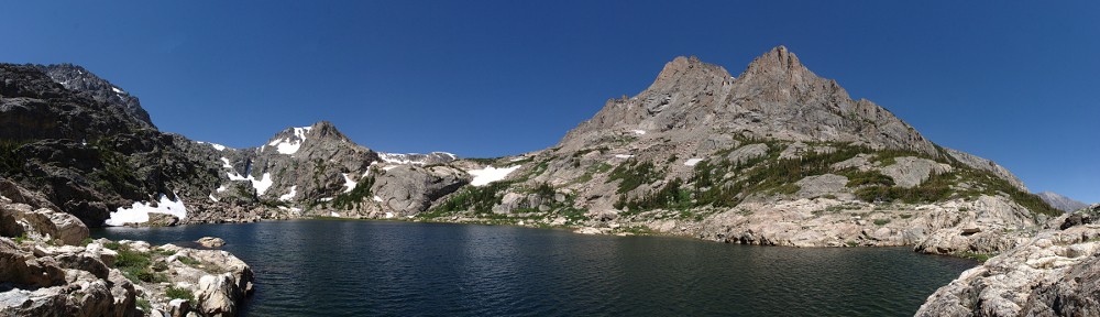
Arrowhead Lake

Sunday, September 8

Until now, whenever I fell short of a hiking goal the destination would get placed on next year’s list of hikes. After making a premature turn on my last hike I decided I didn’t really want to wait the better part of a year to make another stab at it. So off I headed to the south eastern corner of the Fall River Pass quadrangle, on the Mount Ida trail towards Gorge Lakes.

Again Trail Ridge Road was traffic-free and fun to drive. I stopped at Rock Cut for a quick look at my destination then headed to the trailhead. I’ve taken photos here several times and was never happy with the result. This time I got a fairly good shot, and include it here. The red line is more or less the route I took, visiting first ‘Amore Lake’, then Love Lake, and finally Arrowhead Lake.

My route, more or less

Poudre Lake was shrouded in mist and a small cadre of photographers was there snapping away. I put boots on the trail twenty minutes earlier than last time and before long passed the point of my errant turn. When the trail got near the edge overlooking what I’ll now refer to as ‘Misplaced Valley’, I wandered over for a closer look.

Not far from there I left the trail and cut across the next ridge to a point where I’d get my first real look on the gorge.

Seven lakes are visible in this photo

A more intrepid hiker than myself might descend here. I’m not a big fan of steep descents, so I continue along the ridge line. My next landmark is cleverly named Point 11819. That is, it’s an unnamed point at 11,819′ above sea level. From here, that’s about a 600′ descent. At this point I considered abandoning the ridgeline and descending straight to Love Lake. It’s not too steep for me, but I figured I didn’t want to miss visiting ‘Amore Lake’ so I continued with the original plan.

Before leaving my vantage point, however, I should have used the telephoto lens to scope out the terrain surrounding the lakes below. Perhaps I’d have seen something to aid in my progress later. I guess I was just too wowed by the scenery to do anything like planning ahead.

Continuing down the ridgeline, I came to a ramp that led to ‘Amore Lake’. This is a pretty little officially unnamed pond. I skirted around the west side of it and went up and over the slight ridge separating it from Love Lake. I quickly found myself in difficult terrain. Trees on a steep rocky slope. I made my way easily enough through these and right into a patch of willow. I started flashing back to my hike to Keplinger Lake. But no worries, I was soon through this patch and descending another ramp to Love Lake.

From here, it looks like Love Lake and Arrowhead Lake are only a few yards apart. It’s more like a couple tenths of a mile and a hundred and fifty feet or so of elevation. Here’s where a bit of forethought would have come in handy. I continued along the west side of the lake, then up and over the slight rise. In retrospect, I think it would have been better to go on the east side of the lake and descend through the trees there. Why? Because I found myself in another giant patch of willow.

Before long, I gave up. You might say I technically didn’t reach Arrowhead Lake because I didn’t get close enough to put my toes in it. I’m going to count it anyway. I perched myself on a rock with a nice view of the lake and the surrounding mountains, set up the camera, and enjoyed my lunch. While relaxing, I surveyed the area in search of a way out that didn’t take me through the willow again. I thought I spied a wildlife trail and when I packed up to go, I headed that way.

This route was an illusion. Short of heading straight up the ridge there was no easy way out. So I forged through this patch of willow without too many new scratches on my legs. A few minutes after muscling my way through I was back on the shores of Love Lake where I refilled my water bottle.

Here I heard voices. I hadn’t seen anybody since early morning when I passed a couple on their way up Mount Ida. I met them at about treeline, more than five hours earlier. Scanning the slope above the lake I saw the first hiker coming through the willow in about the same place I went. He was talking to a companion, suggesting a route. After several minutes I saw four hikers total. Only the fourth found the route I intended to take out, missing the willow entirely.

I chatted with these guys for a few minutes. It was about 1:30 now. They asked if I went along the ridge above us and when I confirmed, they mentioned they’d seen me. This must have been nearly two hours earlier, as I’d spent an hour at Arrowhead. They came via Forest Canyon Pass. If I ever return here, I’ll give that route a shot for reasons that will become clear soon enough. I asked if they were spending the night, but they said that wasn’t in their plans. I wonder how long it took them to return to their car.

Gathering Storm

As we separated, it began to rain. It didn’t look to last too long so I didn’t bother with the poncho yet. The next mile or so from here would be grueling, gaining about a thousand feet. I considered cutting across ‘Misplaced Valley’ and returning to the trail using the same route I explored three weeks ago. The idea was, I’d need to gain about 400′ less elevation. But when I saw where I was, I decided to stay on my route in. To cut across here, I’d have to go down a few hundred feet so there’d be no real savings.

Arrowhead Lake and Mount Julian

So I continued my climb. A few minutes later it started raining again. I had to often pause to take in the scenery. And to take in oxygen. I stopped and faced nearly due east. The wind was at my back, rain coming down at enough of an angle to keep my front dry. Judging by the clouds above me and the prevailing winds, I figured the rain would stop shortly. I continued my slog up the ridge.

Feathered friends

Subtly, the wind shifted. I was under the edge of the rain cloud, but it was now moving south to north. I’d be right under this edge for a while unless the wind shifted back. The rain turned to hail for a short while and I donned the poncho. Looking to the north, things were getting ugly. I saw lightning strike on the other side of Trail Ridge Road. In the grand scheme of things, this is not very far – three or four miles as the ptarmigan flies.

This was not a happy development. I reckoned I was still two and a half hours away from the trailhead, and nearly the entire way is above treeline. I intended to stay well below the top of the ridge in order to gain as little elevation as necessary. This now seemed like a doubly good idea considering the weather. I couldn’t really increase my pace as I was climbing steadily. And I had to cross the occasional pile of rocks, which were now slippery with rain.

I took fairly regular breathers. I’d pick a point ahead, tell myself not to pause again until I reached it, pause for a few seconds and repeat. During one of these many pauses, I heard elk bugling below me in ‘Misplaced Valley’. ‘Tis the season! I wasn’t seeing any lightning ahead of me, but my vision was somewhat limited by the hood of the poncho. Thunder did occasionally boom, reassuringly distant. During my pauses I’d scan the slopes north of TRR – that’s where all the excitement was.

On the way up the Mount Ida trail, both this time and three weeks ago, I was thinking I’d have preferred the trail to be closer to the top of the ridge. Now, though, I was somewhat chagrined that it wasn’t a bit lower. When I regained the trail, I still wasn’t seeing any lightning but the thunder was noticeably more numerous but thankfully still some distance away.

I now increased my pace. The rain was coming down fairly steadily, and my poncho had developed a tear. If I let go of it, the poncho would slip backwards and the tear would get bigger, so I had to keep a hand on it. The pleasant morning walk and the hour lazing in the sun at Arrowhead now seemed like distant memories. I was no longer having any fun.

By the time I reached treeline, the peals of thunder were almost continuous and the lightning strikes were around me in all directions. Thankfully, none appeared to be within a mile, but still too close for comfort. I was happy now to be in the trees. Again I heard the bugle of an elk, much closer now than when I was atop the ridge. Normally, elk are seen and not heard. Today it was the opposite.

When I finally reached the car, it was raining quite heavily. To add to the fun, I had just had the car detailed. It was as clean as it had ever been since I bought it. When getting off the trail, I’ve always been able to sit in the open car door and change from boots to driving shoes but not today – muddy boots in the nice clean car. Oh, well.

It rained nearly all the way to Lyons. Between the three hours or so of rain while hiking and another hour and a half on the drive it was a pretty good downpour. But that was only a hint of what was to come. As I write this, both Estes Park and Lyons are cut off from the world; roads covered by debris or washed away. Nearly a whole year’s rain has fallen in the last couple days. I’ve seen video of downtown Estes Park and the water is perhaps as high as it was when the Lawn Lake damn burst back in 1982.

Timetable

 UpDown
Trailhead (10,758′)07:40 AM04:50 PM
Milner Pass trail jct07:55 AM04:35 PM
Unknown trail jct08:25 AM04:10 PM
Overlook @ 12,440′10:25 AM 
Arrowhead Lake (11,120′)11:30 AM12:30 PM

Ouzel Lake

Mike and I talked about hiking to Pipit Lake. It hadn’t really occurred to me to hike there in winter; I guess I’m still stuck in the “hiking is for summer” mindset. But after trading a few emails on Tuesday, we decided to go the next day. It would be the best weather for at least the next week.

I picked Mike up at the park and ride and we headed to the park. His bus was a few minutes late, and we were in the teeth of rush hour traffic into Boulder so we didn’t exactly get an early start. The Wild Basin entrance station is closed for winter – that is, there is no ranger there. That’s pretty much standard year around, if you arrive early enough. Up the road we go, only to find the gate closed before the road crosses the river. This was new to me. I really had no idea when that gate was ever closed. I thought perhaps it got closed when snow piled up on the road.

We geared up and started up the road. The thermometer read 44 degrees when we left the car at 9:00. On the drive up, the sky was mostly cloudy, with some rather ominous looking dark clouds to the west. At the trailhead, though, it was clear blue skies above us and to the west, with fairly strong winds. It took us twenty minutes to reach the trailhead; we figured we’d hiked a mile already.

We made good time on the first part of the trail to the campsite shortcut. We’d passed a few trees that had fallen across the trail, something I’d not seen here before. Approaching Calypso Cascades, there was a spot where water flows over the trail. There are several logs serving as steps; water had filled the spaces between the logs and frozen making terraces of ice – miniature skating rinks.

From Calypso Cascades to a bit past Ouzel Falls the trail is on a north facing slope and is now covered with ice or packed snow. There’s not much snow on the ground, just on the trail. I don’t know how this season compares to normal, I suspect it might be drier than usual, but it’s still early.

We took a short break at Ouzel Falls. A great mass of ice has built up at the base and it looks like the ice at the left side forms each night and melts during the day. A large chunk fell off while we were sitting there.

Continuing, we paused for a minute or two at the next trail junction, where the Thunder Lake trail goes right and Ouzel/Bluebird goes left. We would soon be atop the ridge which had burned back in 1978 and I anticipated it would be quite windy. Time to put on a hat to keep the ears warm. Gaining the top of the ridge, the wind was breathtaking at times. The occasional gust stopped me in my tracks. There is no shelter on this section of trail, which is not so good when it’s windy or in the summer sun. But it’s always good for the open views of the surrounding mountains.

At the lake I set up the GoPro for a time lapse. I didn’t bother with the SLR as there were very few clouds, just a few small ones above the nearby peaks that dissipated before they moved too far. Also, I found that the original battery for the SLR had died after taking only a handful of shots during the hike to the lake.

We looked for a place out of the wind to have our picnic lunches and ended up at the campsite. No view, but mostly out of the wind. After a short while, I went back to the shore of the lake and retrieved the camera. I had placed it on a rock only an inch or so above the ice. It was the best I could do, but not good enough. The wind had blown it over. I managed to salvage the footage. I didn’t do any fancy cropping to simulate pans or zooms; all the camera motion is caused by the wind. The first segment is at half normal speed (two seconds per minute) while the second segment is normal (one second per minute).

On the way out, we opted to continue a short way up the Thunder Lake trail to the upper junction of the campsite shortcut. It’s always nice to see a little different terrain. I think the shortcut saves six or seven tenths of a mile when hiking to Thunder Lake, but we had to go four tenths to get to it. So the hike out was a few tenths shorter than the hike in. We were also on the sunny side of the valley so we took another short break there.

By now I was figuring we were the only visitors to Wild Basin. I was surprised when we encountered three groups of hikers heading toward Calypso Cascades (two couples and a solo hiker). In retrospect, we probably would have met somebody at Ouzel Falls. We were the first ones to the end of the road in the morning, but when we returned to the car there were about a dozen other cars there. Not alone in Wild Basin, but only meeting five other people on that lower section of main trail is about as much solitude as can be expected.

Timetable

Car 09:00 AM
Trailhead 09:20 AM
Campsite shortcut (bottom) 09:50 AM
Calypso Cascades 10:00 AM
Ouzel Falls 10:30 AM
Thunder/Ouzel jct 10:50 AM
Ouzel/Bluebird jct 11:35 AM
Arrive Ouzel Lake 11:50 AM
Depart Ouzel Lake 12:35 PM
Ouzel/Bluebird jct 12:50 PM
Thunder/Ouzel jct 01:25 PM
Campsite shortcut (top) 01:35 PM
Campsite shortcut (bottom) 02:10 PM
Trailhead 02:40 PM
Car 03:00 PM

Lake Helene

As I mentioned in an earlier post, I’ve been wanting to hike to Tourmaline Lake. It’s in a small canyon west of Odessa Lake, which can be reached from either the Fern Lake or Bear Lake trailhead. I was all set to go there via the Fern Lake route when the fire broke out and every trail north and west of Bear Lake was closed. The Fern Lake trailhead is still closed, but hikers are now allowed to get to Odessa Lake from the Bear Lake side.

Taken from Bear Lake road in Moraine Park.

Once snow is on the ground, I’m less inclined to take the longer hikes. From Bear Lake, Tourmaline Lake is about 4.5 miles. That’s about two-thirds of a mile less than from the Fern Lake trailhead but it’s probably not any easier – the highest point on the trail from Bear Lake is near Two Rivers Lake, which is higher than Tourmaline Lake. Then you descend about 600′ to Odessa before gaining those 600′ back. On the return, you get to do the up and down again.

I didn’t really know how much snow to expect. The updates for the fire said it snowed two inches one day. I figure that probably won’t obstruct the trail but there’s no trail from Odessa to Tourmaline. Also, it’s always pretty windy up there, so two inches of snow could get redistributed in drifts. And always wanting to travel light, I didn’t want to take snow shoes. So I set off toward Tourmaline Lake with the expectation that I might not actually make it there.

The day started off crisp and clear but a bit on the breezy side. I arrived at Bear Lake at about 8:30 and was thinking at first that I might not have dressed warmly enough. I was expecting a fairly warm day for this time of year and wore a couple of shirts and a windbreaker, along with gloves and a knit cap. But I figured it was still pretty early; it would probably get 20 degrees warmer by noon and the hike would get me warmed up. By 8:45 I had my boots on and was on the trail. As I said, I didn’t take snow shoes but I did put my micro spikes in the pack.

The path around Bear Lake was a sheet of ice. The first part of the trail is the same as that for Flattop Mtn. The trail goes up the side of a ridge, initially on the sunny south facing side, then crosses to the north face. Where the sun shines on it, it was covered with ice but once reaching the north face it is just packed snow. There isn’t a lot of snow on the ground yet and the trail is quite easy to follow.

Although I thought I was hiking slower than usual, I reached the Flattop/Odessa trail junction in my usual time. The trail is in forest and affords no views except for a couple of places where you can see Bierstadt Lake and points east. From here the trail bends more to the west along the foot of Flattop Mtn, climbing slowly but steadily. Two Rivers Lake and Lake Helene are off the trail to the left under the craggy north face of Flattop and the dramatic Notchtop.

After catching a glimpse of Two Rivers Lake through the trees, the trail starts to descend slightly. Here the snow was getting a bit deeper on the trail where the wind piled it up in small drifts. The trail makes a sharp turn to the north but all the footprints in the snow headed off the trail towards Lake Helene. I continued along the trail which gets a bit steeper now. Very quickly Odessa Lake came into view, partially frozen over. Also very quickly, the drifts on the trail got much deeper. I decided I can wait to reach Tourmaline Lake until next summer, but I still wanted to go a bit farther down the trail with the idea of getting a better view of the burn area. Alas, there was no end of the deep drifts in sight so I turned around and headed for Lake Helene.

I left the trail a bit before I came to everybody else’s footprints. There is a vague trail that leads to Helene’s outlet stream. Topping this small scramble of rocks I found myself at the northern end of the lake. Winter hiking is still new for me, and I’m still surprised how much lower the water level is compared to spring and summer. I could walk twenty feet or more from the grassy summer shore to the edge of the ice today. And it is solid ice, already supporting my weight.

I walked around the lake taking pictures and looking for a sunny spot on a rock, out of the wind. There aren’t any. I might have been disappointed, if it had been closer to lunch time, or if the sky wasn’t absolutely cloudless. After wandering around for about twenty minutes, I headed back toward Bear Lake.

I thought about stopping at Two Rivers Lake, but figured I’d also fail to find a sunny spot out of the wind and there was no prospect of clouds for an interesting time lapse. And I’d stopped there back in April so it’s not like I haven’t been there recently. I was a bit hungry, though, and didn’t want to wait to eat until I got back to Bear Lake. Before long I found a nice sunny becalmed rock and tucked in.

My sandwich was already a memory when the birds arrived, begging. Two little chickadees (I think; I don’t know birds) were interested in my lunch. I don’t feed the wildlife, at least not intentionally. One bird was quite brave, flitting from one spot to another, all within arm’s length. After a few minutes of this, he got even more brave and landed between my feet and found a crumb of bread I’d dropped.

On my way again, I shortly arrived at a place where the trail traverses a talus field and has a view of Joe Mills Mtn. By now some clouds were forming. I decided to set up the GoPro and grab a quick time lapse. I found myself in the shade with no place to sit down and relax so I wandered up and down the trail a bit to keep warm. There was one spot with a small break in the trees where I could see to the north – a slightly obstructed view of the fire area.

By now it was a very pleasant day; it had warmed up nicely and the winds had died down a bit. Because I was hoping for a longer hike, I was back to the car quite early. And because my little time lapse segment was quite short, I set the camera up with a view of the parking lot and let it run a few minutes.

Timetable

Out In
Trailhead 08:45 AM 01:10 PM
Flattop/Odessa jct 09:12 AM 12:44 PM
Lake Helene 10:35 AM 10:55 AM


Chickaree Lake

For the last week or so I’ve been looking forward to hiking to Tourmaline Lake. Unfortunately, a forest fire started near the Fern Lake trail head and there are a number of trail and road closings. Hopefully they’ll get the fire taken care of in short order but it’s hard to guess when I might be able to make that hike.

Wanting to take advantage of good weather, I scoured the maps and the Foster guide for a Plan B. I didn’t want to hike somewhere I’ve been before and I wasn’t feeling up to a very long hike. After quite a bit of deliberation I decided to hike to Chickaree Lake, an easy 2.6 miles and 480 vertical feet from the Onahu Creek trail head.

Because it was a short hike, I was able to sleep in a bit, even though the trail head is on the west side of the park. For these west side hikes, I generally take I-70 to US 40, over Berthoud Pass and through Winter Park, Fraser, and Tabernash to Granby, then east on US 34 and into the Park. On the way home it’s over Trail Ridge Road to Estes Park and US 36 through Lyons to Boulder and then home. All told, it’s probably five hours of driving depending on traffic on Trail Ridge Road. But it’s a nice loop and can be a fun drive if traffic isn’t too bad.

I hit the trail at 10am. It was not much above freezing, but calm with sunny blue skies and few clouds. The trail starts off more or less parallel to the highway for a short distance, then the highway bends west and the trail bends east. If you get an early start on these west side hikes, you often get to see moose, deer, and elk in the meadows. Today I saw none of these, but did hear a few elk bugling somewhere to the south of me.

The trail passes through lodgepole pine forest, undulating up and down a bit. The trail is often free of rocks and roots and when it gets wet it gets muddy. It was dry except for a few puddles and occasionally in the dried mud I could see the prints of elk who had used the trail. At one spot there was even a bear paw print in the dried mud. It looked like the bear was stalking the elk, but who can really tell? The prints may have been made hours apart.

Beetles have killed a large number of trees in this area. Maybe two-thirds or three-quarters of the trees are dead. In some places, the trees are quite mature, with trunks a foot or more in diameter and spaced twenty feet apart. In other places, the trunks are only four to six inches in diameter and the trees are four to six feet apart. Lodgepole pine are straight and tall with short branches, so even with closely spaced trees the forest is quite sunny.

When researching this hike, I read reports that there are (or used to be) ranger led hikes to this lake as often as twice a week. Even with small groups, if there’s that much traffic to the lake I was expecting to see traces of a trail. The Foster guide says to climb to a specific elevation then head northwest. This elevation would be before the trail crosses Onahu Creek but I didn’t see any sign of a trail to the lake.

Upon reaching the creek, I left the trail and headed northwest. I was making good time – I had expected to take about an hour to get here, but it had been only 35 minutes. According to both the map and the Foster guide, I could expect to cross a tributary of Onahu Creek before long. “Bushwhacking” is the term generally used, but because the forest is thinly vegetated it was a pretty straightforward walk. There is quite a bit of deadfall, but this section of the forest features the smaller trees so it was more stepping over than climbing over them.

After a while I was starting to doubt my pathfinding abilities. I saw no sign of a stream. Perhaps I had read the map wrong. When the trail reached that last stream, there was a sign identifying it as Onahu Creek. Maybe the sign or the map was wrong, and I had turned off too soon? I did seem to reach the creek pretty quickly. And in the forest there are no landmarks to assist in locating myself on the map. Just as I decided I’d turned off the trail too soon, I saw the lake through the trees. I had indeed walked straight to it.

Chickaree Lake lies in this thick forest on a bit of a bench. It has no inlet nor outlet stream and I was somewhat surprised at how big it is. It also has no interesting views. I went around the lake looking for a suitable place to set up the cameras and eat my lunch. I picked a spot and got the cameras up and running. As usual, I brought the GoPro for the time lapse and the SLR for everything else. I also wanted to shoot a time lapse with the SLR as I’ve been unhappy with the GoPro’s extremely wide angle and its lack of viewfinder.

After failing to get the SLR running properly for a time laps on the Sky Pond hike, I was a bit more prepared this time. I brought both batteries (fully charged) and had corrected my error with the intervalometer’s settings. Before long, I noticed that the battery indicator was reading low. A few minutes later it died completely. I swapped batteries and started it running again, keeping a closer eye on the battery indicator. The second battery also was discharging quicker than I expected. I got only 160 shots with the first battery. I didn’t want to run the second one all the way down, so I stopped it after 320.

Unfortunately, the skies weren’t cooperating with me. There was one saucer shaped cloud to the east and it never seemed to move. I made a video using both cameras as a sort of comparison, but the ripples on the lake are probably more interesting than the sky. Oh well.

After packing up my gear, I finished circumnavigating the lake. I figured I had no real chance of retracing my steps so I just headed in the correct general direction. Before long I found what looked like a trail, so I followed it. This didn’t last long – it petered out, but even if it hadn’t, I’d have left it as it was heading too much to the east and uphill. I finally did cross a trickle of water. If this was the tributary the map and guide indicate, I can only assume it’s more substantial earlier in the season.

I made it back to the trail in good order. I found the trail before I found the creek, although I could hear the creek clearly and knew I was quite close. So I returned to the trail about a tenth of a mile above where I left it. The hike back to the car was uneventful. I ran into three pairs of hikers on the way out, nobody on the way in.

For the drive home, I decided it was warm and pleasant and could do the drive topless, so off with the roof. I knew it would be cool and windy on Trail Ridge, but leave the windows up and keep the jacket handy and be ready to turn the heater on if necessary. Traffic was fairly light, being a weekday in October.

I didn’t see any smoke from the Fern Lake fire until I got to the Forest Canyon overlook. I pulled over there and hiked up the road a few hundred yards to try to get a better view.

I thought maybe a better view could be had at Many Parks curve, but the parking area there was cordoned off for use by the firefighters (although none were there at the time).

Here are a couple more views from above Upper Beaver Meadow.

Timetable

Out In
Trailhead 10:00 AM 01:10 PM
Onahu Creek 10:35 AM 12:30 PM
Chickaree Lake 10:55 AM 12:10 PM

Ptarmigan Lake

A quick glance at Google tells me there are two Ptarmigan Lakes in Colorado. This one, of course, is in RMNP. The Foster guide lists two ways to get there, one from the North Inlet trailhead and the other from Bear Lake. I hiked the North Inlet trail last September as far as Ptarmigan Creek, where I headed off-trail to Bench Lake. It was over seven miles to Bench Lake, and to proceed to Ptarmigan Lake would entail a couple more miles of bushwhacking. So I chose to start at Bear Lake, hike to the summit of Flattop Mtn, take the Tonohutu Creek trail northwest, then head off trail to the west and descend the better part of 900′ to the lake.

The trail up Fattop Mtn (12,324′) is busy and well maintained. It is the most popular route for hikers to reach the continental divide from the east side of the park. It’s about 4.4 miles from the parking lot to the sign at the trail junction at the “summit” (it’s flat on top, of course, so the generally accepted summit is the sign at a trail junction) and climbs 2,874′. Near the start of the trail, you get a nice view of Long’s Peak, then nothing but forest until reaching the Dream Lake overlook about a third of the way up. The next landmark is the Emerald Lake overlook about two-thirds of the way. From there, the trail takes you to the northern flank of Flattop, overlooking the Odessa Lake trail. It’s common to hear marmots barking their alarms as you work your way up the trail.

I’ve been on the top of Flattop several times. I’ve headed south to descend Andrew’s Glacier twice, summited Hallett once, and just sat above Tyndall Glacier for a picnic a few times. This was my first time taking the trail to the north. Not far along the trail you reach another trail junction, this one the North Inlet Trail. The Tonohutu Creek trail then proceeds along the eastern edge of the divide toward Ptarmigan Point, affording a nice view down the valley towards Odessa Lake: Ptarmigan Glacier, two unnamed pools, Lake Helene, Two Rivers Lake, and Odessa Lake are all visible below Notchtop Mountain.

The trail undulates a bit then turns almost due north near Ptarmigan Point. I headed off the trail, down the gently sloping tundra more or less in the direction of Snowdrift Peak in the distance. The mountain slopes gently at first but steadily becomes steeper and before long the lake comes into sight. I was expecting to descend a talus slope but it was almost entirely tundra. The descent is about 800 vertical feet from where I left the trail and it happens in a very short distance.

I set up the camera for the time lapse and ate my lunch. I wanted to stay for an hour, both to get a nice long video and to rest up for the steep climb back to the trail but I didn’t like the looks of the darkening clouds. After about 40 minutes I packed up, headed near the outlet for a quick panorama, then started the steep ascent.

About half way up I turned around to check out the view. I could now see Snowdrift lake to the west. I was about to take a picture, but the wind kicked up rather fiercely and nearly blew me over. It was so strong, in fact, that it made the steep climb much easier. I quit zig-zagging my way up the slope and headed in the same direction as the wind and was onto nearly level ground in no time.

Then the snow started coming down. “Coming down” isn’t exactly correct – it was coming sideways. In no time visibility to the north was very limited. Hallett Peak was just a silhouette and the peaks beyond it were totally obscured. Meanwhile, the Mummy range to the northeast was still bathed in bright sunshine. The blizzard continued for about a half hour, much to my chagrin. I was dressed in my usual hiking uniform of Hawaiian shirt and shorts (plus a windbreaker).

The weather finally broke when I started down the east side of Flattop. There I found a group of ptarmigans grazing in the tundra. (What’s the group name for ptarmigan? A pton?) They were conveniently working their way across the trail when I arrived and didn’t seem too bothered by me.

The remainder of the hike was under mostly clear, blue skies and the wind died down to a gentle breeze. Hard to believe I was experiencing such wintry conditions just a short while before.

Here’s the obligatory time lapse. It includes a short sequence filmed at Emerald Lake overlook on the way up and another from Dream Lake overlook on the way down. Yes, the weather varies that much in just a few hours on the continental divide!

Timetable

Out In
Trailhead 07:30 AM 03:20 PM
Odessa trail jct 07:55 AM 02:50 PM
Emerald Lake overlook 09:00 AM 01:30 PM
Flattop summit 10:00 AM 12:45 PM
Ptarmigan Lake 11:05 AM 11:45 AM