Return to Spruce Canyon

Back in August of 2019, I made an attempt to reach the four lakes at the head of Spruce Canyon: Hourglass Lake, Rainbow Lake, Lake Irene, and Sprague Tarn. I made it to only the first of those. It was a fairly miserable hike.

Last year, I visited Spruce Lake (which, curiously, is not in Spruce Canyon). The idea on that hike was to see more of the East Troublesome burn scar. Much of the trail passes through forest that was thoroughly burned. It seemed to me that a motivated hiker might be able to bushwhack up Spruce Canyon a lot easier now. I know the trees and deadfall don’t burn to ashes, but judging by much of what I saw, the underbrush should be pretty much gone, and with nothing but burned trunks standing, visibility for route-finding should be much improved.

So I decided to make a return trip.

Tuesday, August 22

Reckoning that it’s only a three-hour hike to the campsite at Spruce Lake, we decided on a relatively late start and lunch in Estes before setting out. We decided on Smokin’ Dave’s BBQ. There’s nothing like over-eating a bunch of barbecue before setting off on a hot day, carrying a 34 lb backpack. Probably not the best lunch choice.

It seems I’m always playing a mental game of “what did I forget” or “what will go wrong”. I don’t think I’m particularly pessimistic about things in general. I often forget things (in spite of constantly making checklists) and nothing ever goes perfectly. I always hope that if I forget something, it’ll be something that’s not mission-critical. And that if anything goes wrong, it’s something minor.

So let’s get this out of the way right off the bat. My checklists served their purpose and nothing was forgotten. But a couple of minor things did go wrong. When backpacking, I carry two water bottles and a Steri-Pen to purify more water. I only need two bottles in camp and on the hike in or out, only one of them is full. Getting out of Gordon’s truck, I managed to drop my full bottle, which pretty much shattered when it hit the ground. The second mishap is that the batteries in my Steri-Pen died after two uses. So, for pretty much the whole trip I was hounding Gordon to filter some more water for me.

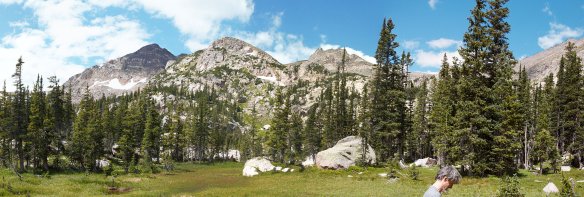
The hike to Spruce Lake was uneventful. It took us just a few minutes less than the three hours I anticipated. There are two campsites at Spruce Lake. Neither was occupied when we arrived, and we took the one closer to the lake (and further from the privy). I’ve always been under the impression that the backcountry campsites get sold out for the year in the first few days of March. I was a bit surprised, then, that nobody ever camped at the other site. On our previous trip a few weeks ago, the second campsite went empty one night. That’s a 37% vacancy rate. Do that many people make reservations but never show up?

When I picked up the permit last month, I was warned that there was a curious moose in the area. And when we entered the park, the ranger said to watch out for the large moose at Spruce Lake. I couldn’t help but wonder, then, if we were to be on the lookout for a large curious moose, or a large moose and a curious one.

After setting up camp, we sat on the shore of the lake to relax. We immediately spotted a bull moose on the far shore. We heard a loud splash a few minutes later and saw a cow moose wading or swimming out into the lake. My first thought was that it was swimming, but it could be that where she crossed it wasn’t all that deep. She was making good progress. Gordon wondered aloud if we should be concerned that she was heading straight for us.

She got out of the water 20 or 30 feet from us, then circled around us to get back into the water more toward the outlet. Meanwhile, the bull was working his way toward the outlet area as well. In 2019, we saw a cow here with a calf. This might be the same cow, and the bull might be the calf. On the other hand, these could be different moose entirely. He was a bit smaller than she. I’m not up on my moose behavior: they’re solitary beasts, and not territorial, but do they tolerate one another?

  • cow moose and bull moose
  • moonset over Gabletop Mountain
  • greenback cutthroat trout
  • Loomis Lake
  • Spruce Lake
  • doe deer

I went back to the camp to have dinner. Before long, the cow traipsed into camp. Not so much into camp as around it. She kept an eye on me as she made her orbit. Was she the curious moose we were warned about?

Wednesday, August 23

To get to the head of Spruce Canyon from Spruce Lake, the idea is to contour around Castle Rock, converging with Spruce Creek without losing any elevation. As I said earlier, I hoped the fire would allow for better route-finding and somewhat easier passage.

We were on the fringes of the burn scar, sometimes in badly burned areas, sometimes in a living forest. Visibility was somewhat better, but the bushwhacking was still grueling. Last time, we only managed half a mile an hour. I don’t think we were moving any faster today. We contoured around a fairly steep section. Where it was burned and steep, the footing was a bit treacherous. By the end of the morning, I’d fallen on my ass four times. Check that – it was three times on my ass, once on my face.

Each time I fell, I’d end up with my hands in the dirt. Each time, ash and soot and soil stuck to my sweating hands. The soil came off easily enough, but the soot and ash clung tenaciously to my fingernails.

Two hours into our expedition I could see ahead to where we were going and back to where we’d come from. I made the executive decision to abort the mission. I do these hikes to have fun. I was wrong that it would be easier this time. Soot stained my hands and pants and dealing with the deadfall was exhausting. I hauled out Plan B: hike to Loomis Lake after a lunch break back at Spruce Lake. Gordon didn’t seem too disappointed to turn around.

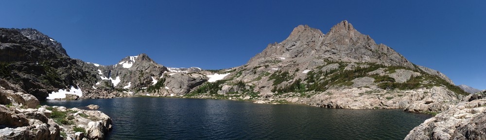
After lunch and a bit of moose-watching, we headed to Loomis Lake. I’ve been there twice before and I don’t recall it being particularly challenging. So I was surprised and disappointed that it was much more difficult than I recalled. As it turned out, on the way up to Loomis Lake, we lost the trail four times. starting right at Spruce Lake. Two other times we lost the trail going around deadfall that blocked the way. For a short while, I felt like I was back in Spruce Canyon.

About two-thirds of the way from Spruce Lake to Loomis Lake, you pass by a pond. There’s a big boulder that in the wettest time of the year is an island but is usually a peninsula. On that rock, clings a fairly good-sized tree. There is no soil, just a few cracks in the granite. That a tree of that size has managed to grow there for decades amazes me. The tenacity of life.

If you manage to follow the trail, it really isn’t a difficult hike. Unfortunately for me, every time I’ve been to Loomis, it’s been overcast. I still don’t have a decent picture of the place. It’s one of those “stark beauty” sorts of places, surrounded by imposing rock walls. The gray clouds and diffused light make it a bit gloomy. I’d like to see it in bright sunlight.

On the way down, we easily followed the trail. It started to sprinkle a bit, threatening rain. Usually, I have to put the raincoat on to make the rain stop; today all I had to do was tell Gordon I might need to stop to put on the coat. Once I said it, it pretty much stopped right away.

We were back to Spruce Lake and camp for dinner and more moose-watching. This evening, it was two bulls. They stayed on the opposite side of the lake, so I didn’t get a great look at them.

I climbed into the sack not long after dark. I’m generally up until well after 11, but I nodded off pretty quickly. At 9:30 it started raining. It really came down for a while, but moderated before long. I don’t know how long it lasted, but it was more than an hour. A good soaking. The tent’s rain cover did its job, keeping everything inside the tent and the little atrium dry.

Thursday, August 24

We awoke to mostly sunny skies – a pleasant morning.

The hike out was just under three hours. We came across a doe that insisted on grazing right next to the trail, not at all concerned about our presence.

My dad always used to say, “I was wrong once. I thought I made a mistake!”

That’s my story with Spruce Canyon. I thought I made a mistake saying I’d never make it to Rainbow Lake, Irene Lake, and Sprague Glacier, but I was wrong!

The other route to those destinations would be from Flattop. It’s not in my day-hike range from there, at well over 8 miles each way and a big climb. And I’ll not make the attempt via Spruce Canyon again, as I said after my first attempt.

So I’ve been twice unsuccessful in reaching three of the four points of interest in Spruce Canyon. I am not disappointed. Both times it was a bit miserable, but a miserable day in the forest is still a good day. I failed to reach my goal, but I’m okay with that. If you always reach your goals, you’re doing it wrong.

Spruce Lake

The East Troublesome fire was first reported on the afternoon of October 14, 2020, eighteen miles west of Rocky Mountain National Park. Nine days later, it jumped a mile and a half over the Continental Divide to Spruce Canyon. That same day, it jumped the mile-wide burn scar from the Fern Lake fire of 2012, ran past the Morraine Park campground and reached Beaver Brook.

The East Troublesom and Cameron Peak fires burned a bit less than ten percent. It’s more than ten if you add in the Fern Lake and Big Meadows fires, both in the last decade.

The thing to keep in mind is that wildfires are a natural part of the lifecycle of the forest. They provide for renewal and increase the diversity of plants and animals. However, we spent a century suppressing wildfires, and we’ve seen climate change contribute to beetle kill. There’s much more fuel in the forests now than is usual. And with increasing temperatures and drought conditions (climate change again), the fires we get burn much more intensely than ever before. Historically, fires were smaller and tended to burn in a haphazard pattern – a mosaic. Today’s fires tend to burn everything. They can create their own weather – when East Troublesome jumped highway 34, it had created winds of 150 miles per hour. The result: scorched earth.

Last week, the NPS posted on Instagram that they had just re-opened the Spruce Lake trail after some trail work. I don’t know how long the trail has been closed – it’s possible it’s been closed since the fire or was just closed for the duration of the work.

I’ve been to Spruce Lake four times, most recently in 2019 on a two-night stay with Gordon, in an attempt to visit the four lakes in upper Spruce Canyon. Although that wasn’t the most pleasant of hikes, I did enjoy the extended time I spent there. I watched a cow moose and her yearling calf for a good, long time.

I wanted to find out how badly burned the place is.

Friday, September 16

My timed-entry permit was for 6-8 am. I arrived at Fern Lake Road at about 7:15. The road was lined on both sides with parked cars. In the meadow right next to the road was a large herd of elk. A disproportionate number of people had serious glass on their cameras, lenses as long as my forearm. I’d guess those guys could count the hairs in the nose of the majestic bull facing them from about twenty yards away.

A few yards up the road, two bucks were grazing maybe six feet off the road. Nobody paid them any attention. I got a picture, though. I see does all the time, but not many bucks.

From the parking lot to a little bit past the Pool, I can’t say I noticed anything different from my last few hikes here. At the parking lot, I noticed that a couple of the tall aspen had been burned, but nothing else looked like it had burned since the Fern Lake fire.

After the Pool, though, it’s a different world.

It is now the end of the second growing season after the fire. When I hiked through the Big Meadows burn scar just weeks after the fire, pretty much everything was black. There wasn’t a blade of grass, not an insect, no birds. The tree trunks were black, the ground was black, many of the rocks on the trail were black.

Two seasons after East Troublesome is already quite different. The black is starting to fade. Plants are starting to cover the ground. Today I learned why fireweed, one of my favorite wildflowers, got its name. It’s mid-September, well past the prime time for wildflowers. But today I saw more flowers than on my last three or four hikes combined. Almost all of them were fireweed. In some places, fireweed must have made up 90% of the plants. It was everywhere.

The tree trunks, both those still standing, and new and old deadfall, are still black. I saw a number of tree trunks had been cut by trail crews in years past. Some of them were unburnt on the cut end. This showed me how deeply the tree trunks are burned. It’s not thick, and it’s starting to flake off many of the standing dead trunks.

Standing on the hillside, looking north to the Fern Lake fire scar, the difference is obvious. Those trees, burned ten years before, are brown. The fresh ones are all black. Eventually, they’ll all be gray and you’ll have to look at differences in live plants to tell which happened first. And it might not be obvious.

The trail zig-zags up a north-facing slope. This whole slope is burned, except along Fern Creek, where some forest survives. Away from the creek, total devastation. After the zig-zags, the trail straightens and heads southwest towards Fern Lake. The trail parallels Fern Creek, but not always closely. Where there was water on October 23, there is still life. I stopped at Fern Lake first, as it’s only about a hundred yards above the trail to Spruce.

The old cabin is gone, razed to the foundation, which is now covered in brown tarps. But most of the trees around and above the lake aren’t burned in the same way as those below. Those below are scorched trunks only. Above, the fire clearly wasn’t as hot. There are still some green, live trees mixed in. And the many of the dead ones still still have their brown needles.

The bridge across the outlet was undamaged, but the privy has been replaced with a brand new one. And I find it a bit amusing that the little restoration area between the trail and the lake survived. It’s not amusing that that bit survived: it’s right next to the water. It’s amusing that one of the few unburnt places is fenced off, with a sign saying to keep out.

The trail to Spruce Lake climbs over a ridge, gaining about two hundred feet on the Fern Creek side. This slope is all burned, but from the top of the ridge, or a bit past, to the wetlands adjacent to Spruce Lake, it alternates between burned and unburned. The recent trail work included rebuilding the bridge with a bogwalk across the outlet. There are a couple of other new bogwalks, too, but others survived (if a bit scorched).

Speaking of trail work, a substantial amount of work was done on the trail where it zig-zags up the slope. There are a couple of long sections where the trail is paved with rock. The width of the trail (about four feet) for lengths of sixty feet in one place and more than a hundred in another. Looks like it’ll last centuries.

Spruce Lake has less damage than Fern Lake. The campsites look undamaged. The privy survived, but just barely: a tree trunk two feet in front of the stool is scorched. The wetlands at the outlet didn’t seem to get burned at all. In fact, there’s an enormous amount of dead tree matter that’s been there for years – it’s all gray – that doesn’t have a black mark on it. I’m amazed it’s still there.

The forest above the lake, on the way to Loomis, looked undamaged except for a small area of “slightly” burned trees (still with needles) high on one slope. Seeing no fire damage on the way to Loomis and an intact forest to the north and west, I decided not to go any farther. More about this decision later.

I haven’t seen any big game since the buck by the side of the road. Before I set out this morning, I was concerned that there wouldn’t be any left in any of this area. I’d imagine any moose or other deer would survive if they could get to the lake. But if they did, is there enough left to keep them here? Although I didn’t lay eyes on any game, I was happy to spot fresh moose shit and deer shit.

After only a short break at Spruce, I headed back to Fern. The idea was to get a short time-lapse sequence there, then hike down to somewhere before Fern Falls to eat my lunch and get a longer sequence, prominently featuring the burnt tree trunks. But, as Helmuth von Moltke noted, “No battle plan survives contact with the enemy.”

The Fern Lake bit of the plan went off well. But the weather was turning. I packed up after only fifteen minutes, and a light rain started to fall a few minutes later. It didn’t take long before it was raining hard enough to convince me to don my waterproof shell. Naturally, as soon as I did, the rain stopped. But I wasn’t fooled and kept it on. The rain came and went until I reached Fern Falls.

I stopped there for a quick snack. The sun was shining again, and it was calm. I took the shell off but kept it handy. The skies looked pretty threatening – everything to the west was dark. I was lucky to have a few minutes of nice weather for my snack and didn’t expect that luck to continue. And, not long after leaving the falls, I had the jacket back on. I wanted to have my picnic, but not in the rain. I hoped I wouldn’t need to eat my picnic in the car.

By the time I was perhaps only a quarter of a mile from the car I decided to stop. The threatening clouds hadn’t moved down the canyon with me. The sun was shining. I found a nice place to sit next to the stream and had my lunch. It wasn’t until a family went by on the trail that I realized just how close to the car I was. They weren’t carrying their toddler, she was walking. Still, better a picnic here than in the car. In the car, I wouldn’t have drunk today’s beer (a returning favorite, Left Hand Brewing’s Wheels Gose ‘Round).

My picnic spot was a three-minute walk from the car.

Conclusions

When I got in the car, I figured I had a few options, depending on what I saw. I could just go to Spruce Lake. Or, if the fire above the lake was bad, I could go to Loomis to check on it. Or, if the fire was worse below the lake, I could contour around and take a look up Spruce Canyon. I took my squirrel-eaten poles with me, in case I went anywhere beyond Spruce Lake. Good plan!

But silly me didn’t bother to refresh his memory about the fire or to even look at the fire history on CalTopo. Had I done this, I would definitely have taken a peek up Spruce Canyon. Now I have an excuse to come back next July or so to put eyes on what I didn’t bother to look at this time.

You see, it occurs to me that, after the fire, another try on Rainbow Lake, Irene Lake, and Sprague Tarn might be considerably easier. Route finding would be much easier, and although the big deadfall will still be there, it should be substantially easier to navigate. I only managed half a mile an hour before, where I generally can manage twice that bushwhacking. It might be worth another shot.

It would mean another two-night stay at Spruce. There’s a privy there. We watched moose eating aquatic grasses. It’s not a long hike. Why not do it again? But only if I get a look at Spruce Canyon first.

Spruce Canyon

I started plotting this summer’s backpacking trips about a year ago. One thing I decided after the last couple trips is that, for where I want to go, spending one night in the backcountry isn’t sufficient. Another thing was that doing zone camping is less than ideal because you have to move your camp from night to night. So this year, my three trips are all two nighters in official camp sites. Hike in on the first day, go wherever I’m trying to get to on the second, and hike out the third.

The plan for this trip was to spend two nights at Spruce Lake and spend an entire day in Spruce Canyon, hoping to visit four lakes: Hourglass Lake, Rainbow Lake, Lake Irene, and Sprague Tarn. In preparation, I had searched for descriptions of the area with very little luck. I found the report of a guy who wanted to summit Stones Peak but changed his mind due to weather. He had a few pictures of the Canyon, but not much description..

So I spent a lot of time studying the map. I had a route planned: about three miles each way, through unknown terrain, and a sprinkling of relativly steep sections to deal with. I’ve done enough off-trail hiking to, I think, have an idea how long it might take to get from one place to another. In this case, I decided I’d be able to go about a mile an hour, and it looked from the map that I’d be able to skirt the steepest bits. I might get a bit out of my comfort zone, but as long as I had a hiking companion I figured this would be a challenging hike, but with a decent chance of reaching my goals.

Gordon agreed to go with me. I hiked with Gordon last year. He races bicycles with some degree of success and thus is in much better shape than I am.

After my last backpacking trip I decided that I needed to buy a backpack. First I used a borrowed one, than one that was given to me. I didn’t particularly like the first one, and the second was too small. So a couple weeks ago I went to REI and bought one.

August 29

Since we were only going to Spruce Lake, about 4.8 miles and a fifteen hundred foot climb, we didn’t need to get to the trailhead early. My only concern was getting a parking spot right at the trailhead. If we couldn’t get a spot there, we might have to park at the bus stop and walk an extra three quarters of a mile.

We left my house by ten, stopped for an early lunch at The Other Side, stopped at the back country office to pick up the permit for the next trip (in two weeks), and headed to the trail. My concern about getting a spot was in vain. Enough folks hike to the Pool or Fern Falls that there’s some turnover in the parking lot and there were a few empty spots. We put boots on the trail at 12:30.

The only delay we faced getting there was an accident on Pole Hill, just before the overlook. A mail truck went through the guardrail and was hanging precipitously off the edge. I’m sure that was a brown-pants moment for the driver.

I’ve described the hike to Spruce Lake before, so I won’t dwell on it here. In the past, I always enjoyed the last section of trail, from just below Fern Lake to Spruce Lake. It’s an unimproved trail with a fair amount of character. Carrying a 35lb backpack changes the character of it a bit. With the backpack I certainly prefer the nice, wide pack trails. With short breaks at Fern Falls and Fern Lake, we reached our campsite a few minutes before four.

To now, I never thought Spruce Lake is anything special. There are many lakes in the Park in spectacular settings. Spruce Lake is not one of them. But Spruce Lake is not without its charms. It is absolutely loaded with fish. Sitting on the shore you can see the greenback cutthroat trout swimming within arms reach. A bit before dusk they were rising, breaking the surface with a soft “plop”, the expanding ripples marking the spot. And at any moment there were maybe two hundred sets of these ripples. That’s a lot of fish!

The fish weren’t the only creatures in the lake. A mother moose and her yearling calf were there. She, wading belly deep where the tops of the long grasses floated, repeatedly submerging her head to pull the grass by the roots, then shaking the water off, sometimes winding the grass around her snout. Her calf was lounging on the shore, mostly hidden. About the time Gordon wanted to get closer for a better view, they decided they’d had enough and moving up the hill away from the lake.

August 30

I was expecting my alarm to go off at six, but I’d forgotten that I’d turned it off. But we weren’t in any particular hurry. Even leaving camp at eight, if we managed a mile an hour we’d have plenty of time to spend at the lakes. So, off we were at eight.

We climbed to about 9800′ and contoured around Castle Rock. Rather than descend to Spruce Creek, we continued along the slope working our way west. When encountering obstacles, we typically climbed above them rather then descending. Making any progress was very challenging. The forest is quite dense, with a lot of deadfall. We came across rock slabs that I was unwilling to cross. We crossed talus fields that sometimes bordered on scree.

At about 10,400′ we descended to the creek and crossed it. My original plan was to cross the outlet of Hourglass to work our way up a gentler slope. But the terrain in front of us was a sea of willow. Gordon suggested we stick to the forest and climb straight up. About four hundred feet up, we emerged onto a large meadow. Being the last week of August, it was mostly dry, but generally it is a boggy marsh. We walked on the firmer bits of earth, but these were still quite spongy, even if dry.

At about 10,900′.

The outlet of Hourglass falls into this meadow from the west. The stream is running at only a fraction of its full flow; the rocks in the stream bed discolored a rusty brown, but water running over half the width, or maybe a bit less. It was fairly easy climbing up alongside the stream, but I think it would be much more difficult when the stream is in full song. After a couple of false summits we found ourselves on the eastern shore of Hourglass Lake.

It was 12:26.

That’s nearly four and a half hours to travel about two and a quarter miles.

Standing at the outlet of Hourglass Lake

We took a short break and continued our climb, looking for Rainbow Lake next. We worked our way through a maze of krummholz until we found ourselves on an outcropping with a fabulous view down the canyon: the Fern Lake fire scar, Moraine Park, and Lake Estes in the distance.

There looked to be one more fairly steep climb to the next bench and Rainbow Lake. I made an executive decision. It was after one now, and I had no expectation that the return trip would be any easier or quicker than our journey here. I called it quits. Gordon said he wanted to check out that last climb and I told him to go for it. I’d meet him back at Hourglass.

Spruce Canyon

He’s so much faster than I am, he’d made it to Rainbow Lake and returned to Hourglass in the time it took me to get back to Hourglass. Granted, I made a bit of a wrong turn and ended up having to navigate some willow. And Gordon admitted to running part of the way. Gordon is somewhat more comfortable on steep terrain than I am and he said it was a challenge for him. Based on this, even if there was no time constraint, I would have had difficulty reaching Rainbow and the other lakes.

In any event, we headed down from Hourglass at about two. Gordon said something about retracing our route in; I said I didn’t expect we’d be able to, but that any reasonable route would work for me. We did cross Spruce Creek at the same spot, and once or twice Gordon thought we passed by this spot on the way up. I wasn’t convinced. For the most part, we followed an entirely different route. Afterwards, Gordon said he thought the return route was worse than the way in. I won’t argue.

We crossed large talus fields then found ourselves descending a couple hundred feet down a gully. Back in dense forest we came to a point were we could see the stream again. I figured we had another hour to go, so I went down and filled my water bottle (for the third time today). I intended to climb back to where Gordon was, but he followed me down to the water a few minutes later and we continued our trek from nearer the stream.

When we’d descended to below about 9800′, we left the stream and worked our way around Castle Rock toward Spruce Lake. In this area we found a few cairns, both in the morning and on our way back. They were scattered so far apart as to be of little or no help to us, and we found them only in the vicinity of Castle Rock.

It was in here somewhere that I got stung by a bee. I haven’t been stung by a bee since I was about four years old. This little fucker got me on my right wrist. It hurt like hell and swelled up a bit. And I don’t know what I did to deserve it.

We returned to our campsite at 6:15. I was spent. It took us more than ten hours to go about five miles. It was physically challenging for me, and due to our slow progress, mentally challenging as well. Had I been on my own, I’d have turned back well before reaching Hourglass Lake. I’m a bit disappointed that I didn’t reach the other lakes, especially given that we were so close.

Given the grueling nature of the hike, I’m not likely to make another attempt. Quite a number of times during the day I found myself asking “What am I doing here? I do this for fun, and very little of this is fun.”

Gordon packed in a six pack of beer. We’d had two of them last night and he put the other four in the lake to chill. He reported that our moose friends were back, browsing around the rock we’d sat on earlier. I went down to the water to watch them. The yearling nearly stepped on our bag of beers. They began working their way towards me. I didn’t really want to be closer to the calf than the mother, so I bushwhacked back to the camp site.

All the afternoon clouds disappeared and we enjoyed the starry night skies. After having two beers before sacking out, I was not surprised that I had to get up in the middle of the night. The Milky Way wasn’t visible when we retired, but it was out in full glory at 1:30.

See more pictures of Hourglass Lake.

August 31

We took our time breaking camp and were on the trail at 8:30. We made it back nearly to the Fern Lake trail junction when I realized I’d left my camera at camp. Gordon volunteered to “run back and get it”. I was selfish and let him. I figured it would take me forty five minutes without the backpack for the round trip. He was back in twenty six (“a nice warmup,” he says). We took short breaks at Fern Falls and the Pool and were back to the trailhead at 11:30.

It’s not a long hike down from Spruce Lake, and the day had not really started to heat up by the time we were done. But I was not exactly moving fast. The fatigue in my legs served as a constant reminder of yesterday’s struggles. My Fitbit tried to tell me I hiked more than twelve miles yesterday. It often overstates distances when I’m hiking. But it sure felt like I’d hiked much more than twelve miles the day before. I’m blaming my fatigue on all the talus we covered, particularly the sections where we were descending steeply. So I didn’t exactly set a blistering pace.

Many times this summer I’ve commented about the crowds in the Park. I think today was the extreme in my experience. The line of cars at the entrance station went all the way to Highway 66. I’d never seen it go past the Beaver Meadows Visitor Center before. And the entire way from Estes to Lyons the traffic heading to Estes was an unbroken line of cars. Assuming an average of 200′ between cars (but it was often much less), over 21 miles that would be 550 cars.

On Reflection

I’m pretty sore right now. I have a blister on my big toe and it hurts a little to go down the stairs in the house. I knew it would be a challenging hike before I started. I only made it to one of the four lakes, and the others were quite close. At times I wasn’t having very much fun. But I’m glad I did it.

I think the new backpack is an improvement over the others. My legs are sore but not my shoulders.

Maybe I should start a list of RMNP lakes that I’ll never visit.

Loomis Lake

Saturday June 16

Loomis Lake sits in a cirque at the top of the southernmost tributary of Spruce Creek. It is surrounded on three sides by the steep cliffs of Gabletop Mountain. The official trail ends at Spruce Lake. Although there is an unofficial trail from Spruce to Loomis, it can be challenging to find.

There’s a large storm system entering the state and so we expected cooler temperatures and a good chance of rain in the afternoon. When I hit the trail, the sky was mostly cloudy and there was very little wind. The main parking area at the Fern Lake trailhead was full, so I parked at the first overflow that’s just a few yards away. While I was putting on my boots, two cars pulled out, and by the time I got back to the car mid-afternoon there were plenty of empty spaces. I wonder if it ever really got full.

The first section of the trail parallels the Big Thompson River for 1.7 miles to the Pool. It’s easy hiking and I made great time. At the Pool there’s a trail junction that has given me a little trouble in the past. Somehow I once managed to misread the sign and ended up on the trail to Cub Lake and had to backtrack.

From the Pool to Fern Falls the trail climbs about four hundred feet. The Fern Lake fire didn’t do much damage to this area. The fire did cross the trail in a few spots but you can hardly tell any more. Occasionally the trail affords views of the opposite slope where the fire was intense erasing that part of the forest, north of the Big Thompson and south of Trail Ridge Road.

When I arrived at Fern Falls I was a bit surprised by the quantity of water in the stream. I’ve been here quite a few times but don’t recall seeing this much water before. I’m thinking this must be the earliest in the season that I’ve hiked here. If all my trips were in July, August, or September, that would account for the difference in the flow.

Although it’s another seven hundred feet or so climb from Fern Falls to Fern Lake, this part of the trail always seemed easier to me than the part between the falls and the Pool. There aren’t any views along this section of trail so it’s a bit pedestrian. Going to Spruce Lake we don’t actually make it to Fern Lake. It’s an easy side trip, though, being about a hundred yards after the trail junction.

To this point, I’d only encountered six or eight other hikers. But just before the Spruce Lake trail junction I got passed by some trail runners. A group of three came by, talking as they ran. If they could still hold a conversation, I figure they need to run faster! Then a couple more passed me. And then even more. It was a veritable marathon.

Turning up the Spruce Lake trail, I left the sudden crowd. I really like the trail from Fern Lake to Spruce Lake. It has character. For long stretches, it hardly qualifies as a trail as it crosses a number of rocky sections. It’s not so rocky that the trail needs to be marked by cairns, but there are a couple of prominent blazes posted on the trees. Spruce Lake is only about a hundred feet higher than Fern Lake. Even with the trail crossing a bit of a ridge between the two lakes there’s very little elevation gain.

Although the trail remains in forest, approaching Spruce Lake you get glimpses of Castle Rock and the Gables. The outlet end of Spruce Lake is fairly marshy and has been closed to hikers for a number of years. This area is the habitat of the boreal toad. I don’t think the toad is endangered, but it may be threatened. So the park service has posted maps here indicating what’s off limits. Anybody entering the area may be fined.

The trail officially ends here at the campsites. However, there are social trails that thread along the northwest shore. The lake is popular for fishing and these trails provide access at least as far as the inlet stream. To get to Loomis Lake, we need to stay on the west side of this stream, so I don’t know if these trails continue farther around the lake.

Here’s where the challenge starts. The trail is faint near Spruce Lake. We’ll be climbing about 400′ in an eighth of a mile, so it’s pretty steep here. I gained and lost the trail a couple of times before finding it for good. After this steep climb the terrain levels out on the approach to Primrose Pond. The first time I was here was in late August, and the water level was about two feet lower. Navigation was easy – I could walk along the dry edges of the pond.

Primrose Pond

In mid-June, though, the pond is at its fullest. And, of course, the trail pretty much peters out. I found a series of cairns that led me on the north side of the pond but before long it became obvious that this was not the best way to go. I backtracked and crossed the outlet and bushwhacked along the southern shores, recrossed the stream, and found the trail again.

The trail dumps you out onto large granite slabs that have no access to the shores of Lake Loomis. The first time I visited, I was content to sit here to watch the world go by while I had my picnic. This time I wanted to get down to the water’s edge, so I crossed the outlet steam and scrambled across a section of boulders spilling from Gabletop Mountain and forming the southern shore of the lake.

I relaxed here for about an hour. This was not only a break from walking, but a break from the constant attack of mosquitoes. I’m not generally bothered by the critters and so I don’t carry mosquito repellent. Sometimes I regret that habit for a few minutes when I pause for a sip of water in dense forest. Today was different. For most of the hike I was besieged by them. I swatted at them constantly. Generally I’d smack them before they had a chance to feed on me; even so, I still managed to have bloody spots all over my arms and hands.

Loomis Lake

Sitting on my rock by the lake I couldn’t help but notice the gathering clouds. That’s not exactly correct: the clouds were ever present. But now their nature appeared to be changing; getting darker, pregnant with rain. Clearly it was getting time to hit the trail for the hike out.

I’ve said before that I often hear voices when I’m alone at these lakes. I’ve decided that they’re generally delusions. Today, though, I didn’t hear voices but breaking branches. A few moments after crossing the outlet I caught a glimpse of other hikers. It was just a glimpse, though. They weren’t close to the trail and I never saw them again.

Nearing Spruce Lake on the way down I managed to lose the trail. Usually I can manage to follow these faint trails once I find them. Today I think I lost the trail on the return farther from Spruce Lake than when I managed to find it on the way up. This time I found myself atop rock outcroppings a couple of times and had to work my way more side to side than downhill to find an easy way.

Satre famously said, “Hell is other people.” When I got back to Spruce Lake I found it inhabited by about eight people. I could hear them well before I gained the lake. They were a noisy bunch, yelling and laughing, splashing in the water. One had even brought a small boombox which could be heard clearly from quite a distance. It’s easy for me to get spoiled on my hikes. Aside from the brief non-encounter with the hikers at Loomis, I had had about three and a half hours of solitude.

It started sprinkling about when I lost the trail above Spruce Lake. It never really rained. From Spruce Lake back to about Fern Falls it alternated between no rain, a light sprinkle, and a thin drizzle. It was never heavy enough for me to bother with my rain jacket.

There are a few lakes nearby that I haven’t visited yet. Hourglass Lake, Rainbow Lake, and Irene Lake all feed Spruce Creek. A fair amount of bushwhacking looks to be involved in reaching these three from Spruce Lake, but I think if I get an early enough start they may be reachable for me on a day hike. I won’t know until I try.

Timetable

There Back
Trailhead 07:40 AM 02:37 PM
The Pool 08:11 AM 02:00 PM
Fern Falls 08:35 AM 01:30 PM
Spruce Lake trail jct 09:07 AM 12:53 PM
Spruce Lake 09:35 AM 12:27 PM
Loomis Lake 10:34 AM 11:54 AM