Monday, October 29
Things are a bit on the slow side at work, and I have a few vacation days I haven’t used. So with the weather looking good for today, I took advantage of the opportunity and headed up to the Park for a short hike. I figured I’d try something similar to my last hike – that is, a short hike to a familiar destination but try to get a different perspective by gaining a little elevation. So I headed up to the Loch, with the intention of finding a nice rock outcropping with a view of the lake and the valley in which it sits.
I wanted to park at the Glacier Gorge parking lot, so I left a bit earlier than last time. This had the side-effect of missing the worst of rush-hour traffic going into Boulder. Between Boulder and Lyons I was treated to a beautiful sunrise, which is always a nice way to start the day.
There was relatively little traffic on US 36 and now that it’s off-season, I skipped my usual detour by the hospital and actually went through downtown Estes Park. Approaching the RMNP entrance station, I saw a few temporary signs indicating that there was a chance of fog or smoke. I thought it was odd, as the weather was fine and the skies were mostly clear. In Moraine Park their electronic sign told me that the Bear Lake parking lot was already full. I wondered how that could be, given that it was 8:30am on the last Monday of October. How can there possibly be that many people there already? If the Bear Lake lot is already full, there’s no way I’ll get a spot at Glacier Gorge.
When I arrived at Glacier Gorge parking lot there were about eight cars there. Clearly the sign in Moraine Park was in error. Two of the eight cars had just arrived moments before I did. Two guys got out of one of the cars, looked at each other, decided it was too windy and got back in their car. I told them it wouldn’t be windy on the trail, but they weren’t convinced. And, actually, I didn’t think it was very windy at all, compared to what I’ve found there in the past.

Andrews Glacier barely visible
Although I’m quite comfortable deciding what to wear and what to carry on my summer hikes, I’m not that experienced in autumn or winter. I think part of my problem is my lumbar pack. It’s sufficient for my summer day hikes but doesn’t allow me to carry what I might need on a colder weather hike. Today I wore my thermal (light or medium, I forget) underwear, hiking pants, Hawaiian shirt, hoodie, and windbreaker. I had a woolen hat and gloves, and I had my rain jacket as well. I brought my microspikes and gaiters, but ended up leaving the microspikes in the car. I figured I probably wouldn’t need them, but once I got off the trail there might be enough snow I’d want the gaiters. In the end, I didn’t use them.
The day was quite pleasant. On the trail, the wind was not an issue and I didn’t think about it until I got near my destination. There was very little snow on the ground for my entire hike, while the trail had icy stretches that became longer and more common as I gained elevation. The ice was only in the shady bits, starting about halfway up the fire trail. About half way between the Mills Lake trail junction and the Loch I encountered a hiker on his way out. He was trying for Sky Pond but turned around at Timberline Falls. All he had was microspikes and that wasn’t enough for him. He was the only person I met since the parking lot.
Shortly after arriving at the Loch I started looking for a place to start climbing. As it turns out, I started climbing too soon. But it didn’t take long to run into the talus field that’s on the south side of the lake. It runs at an angle. If I’d kept to the trail for a little longer I’d have come across it and had an easier way up.

Picnic view
In planning the hike, I had considered following this talus field all the way up to one of Ed’s glacial knobs. But I found a nice place with a view of the valley that was in the sun and out of the wind. I was perhaps two-thirds of the way up the talus. There was a bit of snow here, but I easily avoided it. I didn’t want to step on some snow only to find out that there’s nothing beneath it but a giant hole.

Interesting grain, a little burned around the edges
In the talus there’s a fair amount of dead wood. Not a lot: it’s a talus field so more or less by definition there aren’t any trees. But there are a few ribs of soil here and there and over the few hundred yards of talus I maneuvered I came across quite a few pieces of deadwood. Each one showed signs of being burned. Some were subtly discolored, just a touch of brown. Others were deeply charred. I assume all these were the result of the Bear Lake Fire of 1900. Burned bits of tree can be found throughout the area, but they’re move obvious here as no trees have grown here in the intervening century.
About two-thirds of the way to the top of the talus field I found a spot with a nice view. As a bonus, it had full sun and was not particularly windy. I fully expected that any place I found that was in the sun and wasn’t surrounded by trees obstructing the vista would be blustery, but my little spot was close to ideal. It may very well be that it wasn’t as windy as it normally is in the cooler months this close to the Divide. But it wasn’t exactly calm. The small clump of trees thirty or forty yards above me sang a bit when the heavier gusts blew by.

Interesting textures
While I let the camera run, and after my picnic, I explored the immediate neighborhood. This meant hopping from rock to rock through the talus. On my way to a spot where I could get a bit of a view of Andrews Glacier, I hopped on a rock that looked to be about three feet on a side. It was a “wobbler”. I’m often concerned that some of the smaller rocks I step on will move, but haven’t had that happen with a boulder this size. Frankly, it kind of spooked me. This one had to be three quarters of a ton or so. I had a quick mental image of it moving a large area of talus; not something I want to be in the middle of. From then on, until I got back to the trail, it seemed like every rock I stepped on moved a bit. I know it was my imagination, but it had me being very careful.
After about an hour of watching the world go by, I packed up and headed back down to the trail. Along the way I came across a large upended stump. Its color matched all the other dead wood nearby, except that it had no obvious signs of burn. What it did have was a rock that the roots had grown around. I took a few pictures of it from various angles; didn’t get one that shows it very well, but so it goes.

Rock encased in wood
Back on the trail I started encountering other hikers. One couple asked if they’d passed Sky Pond. I told them that they hadn’t, and that they weren’t likely to make it past Timberline Falls given that they lacked any kind of traction devices. The next couple I came across said they were properly equipped, and I wished them luck. They looked to be fit, but it seemed to me they wouldn’t be getting up there until fairly late in the day.

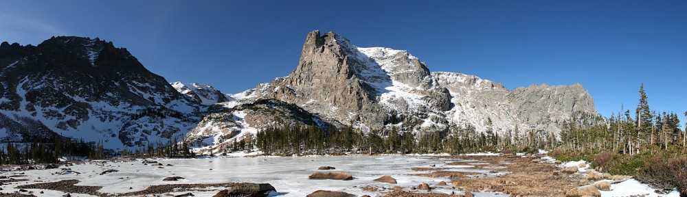
The Loch
I briefly considered taking the long way back to the car and spending a few minutes at Alberta Falls. Maybe I was feeling lazy, maybe I preferred the solitude of the fire trail, and in the end took the shortcut. As I hiked out, I shed my layers ending up in shirtsleeves. The forecast high for Denver was in the mid-70’s, while NOAA predicted a high in the mid-40’s for Loch Vale. No doubt, it was warmer than the mid-40’s where I had my picnic.
Leaving the park I saw why they had signs up warning of smoke or fog: they were doing a prescribed burn on the north side of the road, covering the whole distance between the entrance station and the Beaver Meadows visitor center. By now all the excitement seemed to be over: I saw a fair amount of smoke but no flames.

Prescribed burn
Timetable
| There | Back | |
| Trailhead | 08:55 AM | 01:22 PM |
| Mills/Loch Jct | 09:35 AM | 12:45 PM |
| The Loch | 10:05 AM | 12:24 PM |
| Picnic spot | 10:43 AM | 11:45 AM |