Sky Pond

Last month I picked up a couple of timed-entry passes for July for the Bear Lake corridor. There aren’t any named lakes in the area that I haven’t already visited, except Marigold Lake, a very minor body of water more or less midway between Odessa Lake and the summit of Joe Mills Mountain. Perhaps I’ll manage to collect that one this summer. But not this time.

Wednesday, July 6

I picked Sky Pond for this trip, as it has been quite a while since I was last there. I described the trail in my last report, so I won’t repeat myself.

The mountains along the divide were wreathed in clouds that looked to be starting to break up a bit. The forecast was for a nice, warm day, so I expected things would clear up a bit. Hopefully the clouds would make for an interesting sky.

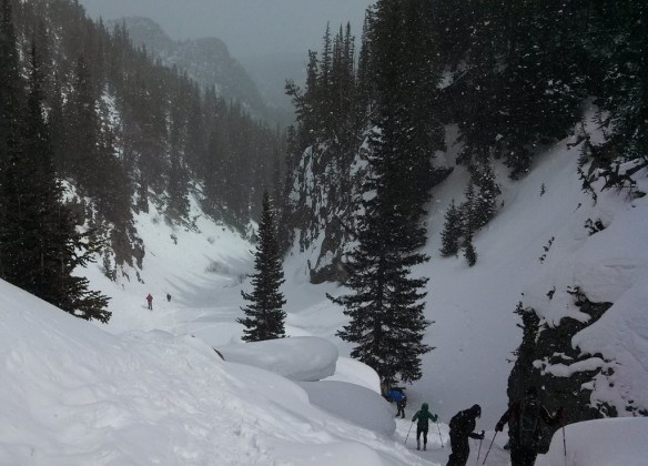
I managed to put boots on the trail a few minutes after 7 am and was at the base of Timberline Falls a bit before 9. There was a fair group at the falls, as this is the chokepoint for the hike. I don’t mind climbing up the section, but it always gives me a bit of heartburn on the way down. Especially “early” in the season, when the water flow is high and the spray gets all the rocks nice and wet.

Here I met volunteer Dan. We chatted for quite a while. I don’t recall his exact words, but he expressed some amazement that so many people manage to navigate up and down this steep bit without any “loss of blood”. He said the climb was much easier six weeks ago when it was all covered in snow. He was able to walk right up the slope.

Even with the pass system in place, these popular trails can get quite crowded. I admit that I’m pretty spoiled on this point, but by seeking out some of the more obscure places in the Park, I can find quiet solitude. Quiet and solitude are quite often not available at Sky Pond. As soon as I sat down on a rock to enjoy the view, I heard somebody fire up a drone. They flew their drone nearly the entire time I was at the lake. I wonder if the drone pilot knew drones are illegal in the Park and was just thumbing his nose at authority, or if he didn’t realize he could be fined $5,000 and spend six months in jail. Just after he retrieved his drone, he looked in my direction and noticed that I was pointing my telephoto lens his way. I was a bit far away to discern his expression. Was it embarrassment?

After listening to the drone for the better part of half an hour, I went down to Glass Lake for another extended break. This time I ran across a woman listening to music as she searched for a spot to watch the world go by. Rather than using headphones or earbuds, she was broadcasting her taste in music to the world, or at least those of us who were trying to enjoy nature.

At the trailhead (well, not exactly the trailhead, but close enough), they have a notice warning of a “habituated” mountain goat in the area. I don’t think I’ve ever seen a mountain goat in the Park. I’d forgotten about this warning until I spotted said mountain goat, who seemed to be following a couple of hikers who didn’t notice who was behind them.

I chatted briefly with one of these hikers, who claimed to have spotted a fox. “I don’t know if it was a fox or a marmot. I think it went under this rock!” I’ve never seen a fox in the Park. That doesn’t mean there aren’t any, but I’m pretty sure what he saw was a marmot.

Back at The Loch, I found that one of the rocky peninsulas on the east side of the lake was unoccupied. These peninsulas, I think, give the best views of Loch Vale. I made my way there for my final extended break of the day. It was noon, and time for lunch. Today’s beer was a Roadie Grapefruit Radler by Great Divide Brewing Company.

On the shuttle bus back to the park-and-ride, the driver pointed out a large bull elk by the side of the road. His antlers were still quite velvety. The driver mentioned this; he would soon rub the velvet off. She told us not to be deceived: the antlers are quite sharp. She said a bull got a bit angry with this particular bus and punched a hole in the side. Naturally, when I disembarked I managed to forget to look for the hole. So it goes.

Snowshoe to the Loch

Friday November 27

Today Ed led me on his off-trail route to the Loch. We met at the Bear Lake parking lot at eight and were on our way by a quarter after. I’ve been to the Loch many times, so I won’t waste a lot of words, but I will say that the weather was nearly perfect, with calm winds, a cloudless, brilliant blue sky, and a surprisingly balmy temperature near thirty. We were at the Loch by noon, and back to the car by two-thirty.

Ed digs a hole in the snow

A bit of explanation may be useful for this one. The snow here was about fifteen inches deep, near the base of a north-facing slope. It was about the average depth we encountered, being quite thin where the wind blew and piled up in other places. Ed is noting the bottom layer of the snow. That first snowfall got melted by the heat still in the earth, then re-frozen. Subsequent snow storms were obvious in the layers.

Critter tracks
A tree with a tree growing out of itself
The Loch
Part of the East Troublesome burn scar

I should have taken a picture of this in the morning, when it was more obvious that the hillside in the center of the photo had burned. I’m sure I’ll have many more opportunities for a better picture. I will note that there are signs forbidding people from walking in the moraine, but there are two people doing just that in the lower left of the photo.

Loch Vale

Monday, October 29

Things are a bit on the slow side at work, and I have a few vacation days I haven’t used. So with the weather looking good for today, I took advantage of the opportunity and headed up to the Park for a short hike. I figured I’d try something similar to my last hike – that is, a short hike to a familiar destination but try to get a different perspective by gaining a little elevation. So I headed up to the Loch, with the intention of finding a nice rock outcropping with a view of the lake and the valley in which it sits.

I wanted to park at the Glacier Gorge parking lot, so I left a bit earlier than last time. This had the side-effect of missing the worst of rush-hour traffic going into Boulder. Between Boulder and Lyons I was treated to a beautiful sunrise, which is always a nice way to start the day.

There was relatively little traffic on US 36 and now that it’s off-season, I skipped my usual detour by the hospital and actually went through downtown Estes Park. Approaching the RMNP entrance station, I saw a few temporary signs indicating that there was a chance of fog or smoke. I thought it was odd, as the weather was fine and the skies were mostly clear. In Moraine Park their electronic sign told me that the Bear Lake parking lot was already full. I wondered how that could be, given that it was 8:30am on the last Monday of October. How can there possibly be that many people there already? If the Bear Lake lot is already full, there’s no way I’ll get a spot at Glacier Gorge.

When I arrived at Glacier Gorge parking lot there were about eight cars there. Clearly the sign in Moraine Park was in error. Two of the eight cars had just arrived moments before I did. Two guys got out of one of the cars, looked at each other, decided it was too windy and got back in their car. I told them it wouldn’t be windy on the trail, but they weren’t convinced. And, actually, I didn’t think it was very windy at all, compared to what I’ve found there in the past.

Andrews Glacier barely visible

Although I’m quite comfortable deciding what to wear and what to carry on my summer hikes, I’m not that experienced in autumn or winter. I think part of my problem is my lumbar pack. It’s sufficient for my summer day hikes but doesn’t allow me to carry what I might need on a colder weather hike. Today I wore my thermal (light or medium, I forget) underwear, hiking pants, Hawaiian shirt, hoodie, and windbreaker. I had a woolen hat and gloves, and I had my rain jacket as well. I brought my microspikes and gaiters, but ended up leaving the microspikes in the car. I figured I probably wouldn’t need them, but once I got off the trail there might be enough snow I’d want the gaiters. In the end, I didn’t use them.

The day was quite pleasant. On the trail, the wind was not an issue and I didn’t think about it until I got near my destination. There was very little snow on the ground for my entire hike, while the trail had icy stretches that became longer and more common as I gained elevation. The ice was only in the shady bits, starting about halfway up the fire trail. About half way between the Mills Lake trail junction and the Loch I encountered a hiker on his way out. He was trying for Sky Pond but turned around at Timberline Falls. All he had was microspikes and that wasn’t enough for him. He was the only person I met since the parking lot.

Shortly after arriving at the Loch I started looking for a place to start climbing. As it turns out, I started climbing too soon. But it didn’t take long to run into the talus field that’s on the south side of the lake. It runs at an angle. If I’d kept to the trail for a little longer I’d have come across it and had an easier way up.

Picnic view

In planning the hike, I had considered following this talus field all the way up to one of Ed’s glacial knobs. But I found a nice place with a view of the valley that was in the sun and out of the wind. I was perhaps two-thirds of the way up the talus. There was a bit of snow here, but I easily avoided it. I didn’t want to step on some snow only to find out that there’s nothing beneath it but a giant hole.

Interesting grain, a little burned around the edges

In the talus there’s a fair amount of dead wood. Not a lot: it’s a talus field so more or less by definition there aren’t any trees. But there are a few ribs of soil here and there and over the few hundred yards of talus I maneuvered I came across quite a few pieces of deadwood. Each one showed signs of being burned. Some were subtly discolored, just a touch of brown. Others were deeply charred. I assume all these were the result of the Bear Lake Fire of 1900. Burned bits of tree can be found throughout the area, but they’re move obvious here as no trees have grown here in the intervening century.

About two-thirds of the way to the top of the talus field I found a spot with a nice view. As a bonus, it had full sun and was not particularly windy. I fully expected that any place I found that was in the sun and wasn’t surrounded by trees obstructing the vista would be blustery, but my little spot was close to ideal. It may very well be that it wasn’t as windy as it normally is in the cooler months this close to the Divide. But it wasn’t exactly calm. The small clump of trees thirty or forty yards above me sang a bit when the heavier gusts blew by.

Interesting textures

While I let the camera run, and after my picnic, I explored the immediate neighborhood. This meant hopping from rock to rock through the talus. On my way to a spot where I could get a bit of a view of Andrews Glacier, I hopped on a rock that looked to be about three feet on a side. It was a “wobbler”. I’m often concerned that some of the smaller rocks I step on will move, but haven’t had that happen with a boulder this size. Frankly, it kind of spooked me. This one had to be three quarters of a ton or so. I had a quick mental image of it moving a large area of talus; not something I want to be in the middle of. From then on, until I got back to the trail, it seemed like every rock I stepped on moved a bit. I know it was my imagination, but it had me being very careful.

After about an hour of watching the world go by, I packed up and headed back down to the trail. Along the way I came across a large upended stump. Its color matched all the other dead wood nearby, except that it had no obvious signs of burn. What it did have was a rock that the roots had grown around. I took a few pictures of it from various angles; didn’t get one that shows it very well, but so it goes.

Rock encased in wood

Back on the trail I started encountering other hikers. One couple asked if they’d passed Sky Pond. I told them that they hadn’t, and that they weren’t likely to make it past Timberline Falls given that they lacked any kind of traction devices. The next couple I came across said they were properly equipped, and I wished them luck. They looked to be fit, but it seemed to me they wouldn’t be getting up there until fairly late in the day.

The Loch

I briefly considered taking the long way back to the car and spending a few minutes at Alberta Falls. Maybe I was feeling lazy, maybe I preferred the solitude of the fire trail, and in the end took the shortcut. As I hiked out, I shed my layers ending up in shirtsleeves. The forecast high for Denver was in the mid-70’s, while NOAA predicted a high in the mid-40’s for Loch Vale. No doubt, it was warmer than the mid-40’s where I had my picnic.

Leaving the park I saw why they had signs up warning of smoke or fog: they were doing a prescribed burn on the north side of the road, covering the whole distance between the entrance station and the Beaver Meadows visitor center. By now all the excitement seemed to be over: I saw a fair amount of smoke but no flames.

Prescribed burn

Timetable

There Back
Trailhead 08:55 AM 01:22 PM
Mills/Loch Jct 09:35 AM 12:45 PM
The Loch 10:05 AM 12:24 PM
Picnic spot 10:43 AM 11:45 AM

The Loch

Jerry and I hiked to the Loch. It was a relatively calm day near the divide, for a change. It was fairly warm, but the sky was nearly solid overcast. Again, we got a late start that was made even later due to another closure of highway 36. We didn’t hit the trail until about 11. But it’s a short hike, so no harm, no foul.

We took the winter route up – the fire trail to the junction, then up Icy Brook to the Loch. The ice on the lake is starting to get fairly rotten – crystallized and porous. We skirted along the south shore until the ice ended on the dry lake bottom. About a quarter of the lake’s summer surface area is dry right now; the lake is much shallower than I expected.

We found a place to set up the camera with some trees nearby to keep us out of the wind, should it arise (and it did, eventually). I normally have the camera pointing to a patch of sky above whatever dramatic peaks I’m nearby, but in this case I figured my best shot at getting any sort of interesting cloud action was to face it east. I’d have set up the SLR as well, but it was malfunctioning. On the way up, I tried to take some photos but, although the batteries are fully charged it wouldn’t do anything. Eventually, I took both battery packs out and swapped their location and I was back in business.

On the hike out, we decided to take the route past Alberta Falls. That turned out not to be the best choice, but so it goes. There was very little traffic this way, so the “beaten path” wasn’t very beaten. We weren’t using snow shoes, so we wanted a fair amount of traffic on the trail before us. The original plan was to follow the stream down (from the bridge on the North Longs Peak trail) to the falls, then take the trail from there. But it was soon obvious doing this with just micro spikes wouldn’t be the best choice. So we followed the footsteps on the summer trail.

The thing about following somebody else’s footprints is you’re assuming they knew what they were doing. There were several times I had my doubts. But every now and then we’d see some evidence that we were on the trail. In between these times, it seemed like the trail blazer was maliciously taking us on an excursion. It was all good, though, as we arrived at the falls to find a bunch of people sitting there enjoying the view of … the frozen falls. Not really much to look at when it’s frozen solid and covered with snow drifts.

The Loch

Last month, Jerry and I failed to navigate to Lake Haiyaha to see the igloos at Stomp IX. That didn’t seem to dissuade Jerry from taking another short winter hike with me, so this time we went to The Loch. I’ve been there many times, but don’t generally make it the destination – it’s just somewhere on the way to somewhere else. It’s a short hike, and in summer it is typically quite crowded. But I find myself more willing to take the shorter hikes in winter.

We hit the trail at about 11. I’m usually on the trail quite a bit earlier than that, but this being such a short hike there was no need to hurry. The weather forecast for Denver was for a warm day, about 70, with a slight chance of rain. Which, of course, tells us nothing of what to expect near the Continental Divide. We dressed warmly; I wore a sweater and my new heavy coat, with a baseball cap to keep the sun out of my eyes, a knit cap for warmth, and my new gloves. I wore the micro-spikes. Jerry decided against snow shoes, which turned out okay. He slipped a bit here and there, but wasn’t the only one without traction aid on the trail.

We managed to find a parking space at the Glacier Gorge lot, which surprised me. With the weather being so nice I figured there’d be quite a few people out on the trails and expected that lot to fill up early. Once on the trail, it wasn’t long before we were thinking we’d dressed too warmly. Hats and gloves were off and jackets unzipped before we made it to the junction with the Fire trail.

TracksWe were expecting a bit more fresh snow than we saw, but I still have a hard time figuring out exactly how old the freshest snow is. We saw a lot of animal tracks and spent some time discussing what sort of animal made each track. We came across an area where there were lots of small tracks and I saw one I thought would make an interesting picture. Before I left the house, I searched for the SLR batteries. I charged one but couldn’t find the other. When I went to take a photo of the tracks, the camera died. So the SLR was not so much a camera as an anchor. I shot the tracks with the cell phone, but I’m sure I’d have had better results with the real camera. I like the way the light went through the snow, illuminating the tracks from underneath.

Taking the Fire trail really does cut down on the traffic. We saw only one other group of hikers before we got to the Mills/Loch/Haiyaha trail junction, but the trail was nicely packed and we had no trouble without snow shoes. We ran into more hikers at the junction. They were headed to the Loch as well. They followed the sign, which put them on the summer trail. We headed up the Mills Lake trail a few yards to the bridge, then up the drainage. This seems to be a navigation problem for lots of hikers. We caught another group who were on their way to Mills. The tracks split at the bridge – right to the Loch, left to Mills. These folks went right before realizing their error.

Snow Cave EntranceGoing up the drainage, the trail gets a bit steep in places. Jerry had a bit of difficulty on theses steeper spots without traction. He joked that going down might be From Insidemore fun – he’d probably have to do it on his backside rather than on his feet. Just before getting to the top of the climb, some hikers on their way down said it was quite windy at the lake. It’s almost always windy at these lakes in winter, so no surprise there.

Once we got to the top, we were delighted to find that somebody had made a snow cave. JerryHard to say how long it’s been there, but long enough for several people to carve their initials on the interior walls. Looks to me like it took quite a bit of effort. The floor of the cave is the grassy meadow. It’s not quite tall enough for me to stand up in, but there was plenty of room for Jerry and me.

On the lake proper, the wind was blowing quite nicely. Snow wasn’t falling from the sky, but quite a bit of it was blowing around along the ground. We found a spot in the trees, mostly out of the wind. I started the camera and we retreated to the trees for lunch. Soon, the clouds came down the valley and snow began to fall.

Here’s the time lapse:

On the way down from the lake, we caught up to a bigger group clearly enjoying their descent. A couple of the girls fell on their butts, accompanied by much laughing. My micro spikes were providing sufficient traction on the steep snow, but it was quicker and more fun to sit down at the top and slide down.The Descent

When possible, I like to take a different route out than we followed on the way in. Jerry hadn’t done any winter hiking in the area, so I suggested we go down past Alberta Falls. I had a bit of doubt when we left the main trail. It looked like nobody had gone this way since the last snowfall. I didn’t want to get into any snow that would be difficult without snow shoes, but it was easy enough to find a “beaten path”. Some footprints were there, just covered by more recent snow. We quickly found the bridge over the stream and re-entered the drainage there.

After a short while, we came across some folks coming up. They said they wanted to go to Mills Lake, but I was skeptical they’d make it. We met at a place where the there’s about an eight foot climb up either ice or rocks. Jerry and I slid down here and I was wondering how you’d climb back up, even if you had spikes. Those folks were wearing sneakers; clearly not prepared to deal with snow. They must have made it to the top of that little bit, as a few minutes later we heard the squeals of laughter as they slid back down.

We ran into a few other folks on their way to Mills. These were better prepared for winter hiking, but they’d not been here before. I did my best to tell them how to get there. They’d be able to follow our tracks except a stretch where we walked across barren rock.

Sky Pond

The trail to Sky Pond is fairly heavily traveled and I’ve been there at least three or four times over the years. Lately I’ve preferred to visit lakes I’ve never been to before, and I’ve come to enjoy the relative seclusion many of these hikes have provided. But I was looking at the map the other day and noticed Embryo Lake, just off the trail where Andrews Creek joins Icy Brook. So off to Sky Pond it was, thinking it may be late enough in the season to be less crowded than usual.

I had hoped to hit the trail by 8:30, but I got off to a bit of a late start. And when I arrived at the park entrance, the express pass lane was closed. It’s another free day in the park. The Bear Lake road is now paved almost all the way to Hallowell Park, but now they’ve removed the pavement from there to the park and ride.

From the Glacier Gorge trailhead, Sky Pond is 4.4 miles one way, with a 1,720 foot elevation gain. But because of my late start, and it being free day, but the time I got there Glacier Gorge parking lot was full and the Bear Lake parking lot was getting there. The trip from Bear Lake to Glacier Gorge Junction adds about a quarter mile to the trip, downhill in the morning but uphill after a long hike at the end.

To offset that, I now know where the ‘Fire trail’ is. I’ve seen it on the old maps but it’s not on the new ones, and I never looked that hard for it. Earlier this year I hiked to Frozen Lake with Ed and that’s how we returned. This cuts six tenths off the trip each way, so in the end I hiked more like 8.1 miles round trip.

The trail was quite busy today, except for the Fire trail, where I saw one other hiker in the morning and none in the afternoon. Other than that, I probably didn’t go more than three minutes without seeing or hearing another hiker.

The Fire trail is supposedly unimproved, but it’s about as unimproved as the back way down from Haiyaha – fairly well maintained. I’ve been on the main trail, to Alberta Falls then to the Mills/Loch junction, so many times it’s become a bit of a chore, a trail to push through quickly in the morning and to endure in the afternoons. So it’s a nice change to go another way, particularly as so few use it.

I made it to the Loch in less than an hour. Here is where you first get a nice view of the mountains – the higher elevations dusted with snow the last few nights. The trail winds around the Loch then goes back into the forest. Just after the turn for Andrews Glacier there is a meadow on the left affording a nice view of Powell Peak and Taylor Peak, with Timberline Falls below, glinting in the sun. It is here one makes a side trip to Embryo Lake, but I decide to save this side trip for the way back.

A few minutes further along and the trail starts to climb in earnest, leaving the forest below and the falls above. The trail is a staircase, long and winding up to the right side of Timberline Falls. At the falls you have to use your hands a bit; I caught up to a young couple here and she had some difficulty deciding how to go about it.

I really don’t like this part of the hike. I find it not so bad going up, but I don’t like the descent at all. This time of year, though, it is much less nerve wracking for me as there isn’t as much water flowing and splashing on the rocks. I didn’t have any trouble today.

Glass Lake lies just above the falls. I always used to see it called “Lake of Glass” but that usage seems to have gone away.

It is only another couple of tenths of a mile, another eighty vertical feet to Sky Pond. It has been windy every time I’ve been there, and usually there’s a rich insect life. Today it was windy but I enjoyed my lunch without interference by clouds of gnats. I sat there for half an hour without bothering to set up for a time lapse as there was not a cloud in the sky.

By the time I left, the lake was beginning to get crowded and I ran into another dozen or so hikers on the trail between Glass Lake and Sky Pond. As I said, I had no difficulty descending the falls and before long was back at the Andrews Glacier trail junction. Here, I set off to the south in search of Embryo Lake.

I quickly found a faint trail that led me to an easy crossing of Icy Brook. After skirting some deadfall and circling around a small mound I found a small meadow with a tiny pond. This must be Embryo Lake. I assume it is cleverly named – it is much too small to qualify as a lake in any regard. And based on the grass around it, I’m guessing it doesn’t get much bigger in the spring.

I was back to the Loch a few minutes after one. By now some clouds were popping up over the divide. I found a nice rock outcropping with a view and set up the cameras. As usual, I brought the GoPro. And this was my first time playing with the intervalometer for the SLR. Problem was, I hadn’t taken the time to figure out how to work it, so nothing came out. To top it off, the battery I popped in the SLR this morning indicated fully charged, but clearly it wasn’t as it died completely within minutes.

Here’s the short clip from the GoPro. Not very good – aimed too close to the sun.

Timetable

Out In
Trailhead 09:00 AM 02:35 AM
Mills/Loch jct 09:35 AM 02:00 AM
The Loch 09:55 AM 01:05 AM
Andrews jct 10:20 AM 12:30 PM
Glass Lake 10:55 AM 12:10 PM
Sky Pond 11:15 AM 11:45 AM

The side trip to Embryo Lake took only 15 minutes, and I spent a half hour shooting time lapse at the Loch on the return trip.