Dutch Town 2

Tuesday, August 30

I awoke a bit after sunrise after a somewhat chilly night to clear blue skies. It looked to be another marvelous day in the Park.

The first thing I noticed was that my trek poles, which I had leaned up against a long, downed tree, had been knocked over. Maybe the deer (or whatever) that passed through last night knocked them over. On closer inspection, though, the grips of both poles had been munched on and the straps had been eaten completely. Did that passing deer eat my poles?

A few minutes later, we were greeted by a Park Service trail crew. They were here to make a few improvements to the campsite. The ranger in charge asked to see our permit while the crew stowed their shovels and axes not far from where Gordon and I put our bear canisters overnight.

Having established our right to be here, I started asking the ranger questions. How did you get here so early? “We drove along the Ditch from Poudre cabin, so we had a short hike.” What creature did this skull belong to? “I don’t know. Not an ungulate.” What do you suppose ate my trek poles? “Probably a marmot. They want the salt from your sweat.” Did this campsite use to be over there beyond the preservation area sign? “Yes. It was threatened by dead trees so we moved it here.”

Last evening I spent a fair amount of time trying to figure out what percentage of trees in the area have succumbed to pine beetles. After much study, it became clear to me that all the dead trees were the largest trees. I’d guess nine out of ten of the largest quartile or quintile of trees were dead but very few of the medium and small trees were. I couldn’t help but wonder if all beetle-kill was this way and I just never noticed it before, or if things were different in this area. So I asked the ranger.

While I was correct that these trees had been killed by beetles, they were from the spruce beetle, which is a cousin of the pine beetle. Spruce beetles go after the big trees first, those with trunk diameters greater than ten inches. The victims in this area have been dead for a while – none are brown, they’re all gray.

Before they worked on our campsite, they headed up to Lake of the Clouds. They said it would take them about an hour to get there from here, which is only a bit less than I’d guessed it might take us. They left and we finished our breakfasts and got ready for our hike.

I grabbed my day pack, which is the top part of my backpack. It has a compartment you unzip to reveal the shoulder straps for the day pack. I’d stored this in the atrium of my tent (the space between the tent and the rain cover). It sat all night about six inches from my head, where the rustling noises were last night. It turns out my marmot friend didn’t just dine on my trek poles but worked my day pack over pretty well. Each shoulder strap was half eaten through and much of the fabric at the top was thoroughly chewed up. I wasn’t hearing the breeze rustle my tent, I was hearing a rodent wrecking my stuff. I hope that marmot got a really bad case of diarrhea.

Luckily, it was still intact enough to get me through the day. I hoped. As long as I didn’t put too much weight in the pack.

Anyhow, lunch and water and GoPro in the mangled pack, using my now strapless and heavily gnawed trek poles, we headed up the trail to Lake of the Clouds.

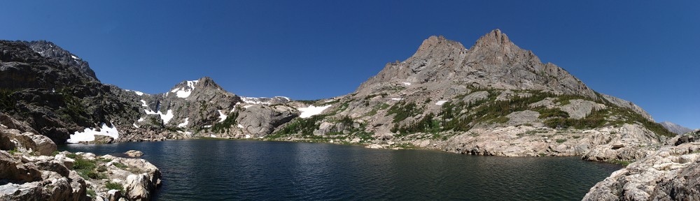
The trail ends well before the lake, where it exits the forest and dumps the hiker on the shore of a sea of talus. To the south, to the north, and to the west, nothing but talus. I vaguely recall writing on this blog some time ago about a large amount of talus. Wherever that was, there is more talus here. (It isn’t only here – our campsite has a view of the north slope of Howard Mountain. It’s all talus. Except for some that looks like scree.)

The first thing I did, once we had the route to the lake in view, was to search for the work party. I found them, but not where I expected them to be. When I was here on my failed day-hike, I thought that if I hadn’t made my 45-minute wrong turn I’d have made it to the lake. I’m pretty sure I wouldn’t have made it because I surely wouldn’t have gone the correct way.

We worked our way across the talus between the end of the trail and the base of the slope we’d have to climb. That slope is talus. We worked our way up between a couple of growths of willow and over to a grassy ramp. Once on the ramp, the route of cairns was pretty easy to follow. There may be cairns in the talus we had to cross, but finding a cairn in a talus field is like finding a pile of rocks in a bigger pile of rocks.

The ramp is broken in the middle by another section of talus. Imagine that. Back on the ramp, following the cairns, we crossed the lake’s outlet stream and arrived atop the bench that holds the lake. It took us an hour and twenty minutes to get here from camp.

The slopes of Howard Mountain and Mount Cirrus rise steeply 1400′ above the lake. You guessed it: talus everywhere. The rocks these mountains are made of aren’t the giant granite slabs you see above Black Lake, for example. The rocks on Howard and Cirrus are fractured and full of cracks running in all directions. The freeze-thaw cycle undoubtedly keeps a significant amount of rock falling, endlessly adding to the piles of talus.

As is my wont, I chatted a bit with the members of the work crew. They were celebrating the end of the season (even though they’ll be working another month). The ranger in charge told me she has been doing this for eighteen years. She’s been just about everywhere in the Park but doesn’t visit very many summits. One of the guys will turn 30 in a couple of weeks. He decided that he’d take a dip in 30 lakes by then. Today he got his 23rd and he’s confident that he’ll get the remaining seven without too much difficulty. One day last week, he got six in one day: The Loch, Mills, Jewel, Black, Blue, and Green.

Gordon set off to circumnavigate the lake while I surveyed my surroundings. Looking out over the valley below, my metaphor likening the talus to a sea couldn’t be more apt. This sea of rock is arranged in what looks like storm-tossed waves. The troughs of the waves are lighter in color than the tops due to weathering.

I was surprised the lake was so green. Fluorescent green, nearly.

We stayed at the lake for a bit more than two hours. On the way down, we lost our chain of cairns a couple of times, forcing us to backtrack. And when we went looking for the terminus of the trail, we found we’d gone much too far to the north. Rather than backtracking across the talus, we worked our way back to the forest and followed a game trail back to the main trail.

When we arrived at our campsite, the work crew had already left. They cut a long section out of the tree trunk I’d had my poles leaning on overnight. This expanded the area where one might want to pitch a tent. As I said earlier, I saw an axe and shovels. But they must have had a power saw and something to shred the tree trunk. To level the ground, they didn’t move any dirt around, they just spread a thick layer of shredded tree trunk. It looked like it might be comfy, but I wonder how well it’ll hold tent spikes and suspect it’ll retain a fair amount of water after a rain.

At ten minutes to four, I thought we were going to get a visitor. Pretty much wherever we sat at the campsite, we could see the main trail. I saw a lone hiker come up to the sign, look up at the campsite, then check his map. He had a full backpack – much more than he’d need for a day hike. My first thought was that maybe he had a permit for this site but showed up a day early. But after a short pause, he continued up the trail. If he was a day hiker, he was pretty late. As it takes more than an hour to reach the lake, he’d be looking at passing our site no sooner than 6 pm. We never did see him again, so my guess is he camped at Lake of the Clouds without a permit. I wonder how often that sort of thing happens.

When it came time to bed in for the night, I made sure to keep wearing my headlamp. If that pesky marmot made a return visit, I wanted to be able to scare him away without rummaging around for my light.

Sure enough, sometime around midnight, I heard a rustling noise. I turned the lamp on and found myself eyeball to beady little eyeball with… a squirrel! The little bastard was about four inches away from my face. The light didn’t scare him off – I had to hiss at him. We repeated this little ritual three or four more times before he finally gave up.

I take back all the bad things I was thinking about marmots.

Dutch Town 1

Foster tells us that Lake of the Clouds is the “most highly visited destination in the Never Summer Mountains”. I don’t doubt her, but if it’s true it tells me just how few people visit any destination in the Never Summer Mountains. (She certainly includes only the mountain destinations and not those in the valley, like Lulu City.)

I tried to reach Lake of the Clouds quite a while ago as a day hike. I wasted some time with a navigation error and made it only to where the trail ends on the map. Since then, I’ve suspected it was out of my day hike range, and decided to give it the two-night treatment: hike to the campsite on day one, hit the lake (or lakes) on day two, and hike out on day three.

The trail is accessed from the Colorado River trailhead. I’ve never seen that lot full, so we could pick our own departure time without worrying about getting a place to park.

Monday, August 29

We had a leisurely 7 am departure from my house, traffic wasn’t horrible, and we put boots on the trail at 9:20.

The first section of trail goes due north from the parking lot for half a mile to a trail junction. Many hikers won’t go any farther than here, or hereabouts. There’s a bridge over the Colorado river a few yards from the junction. Most of those who don’t stop here will continue on toward Lulu City. To reach Lake of the Clouds (or our campsite, Dutch Town), you make the left turn and take the route less traveled.

After crossing the valley, the trail turns south to climb the lower flank of Red Mountain. The trail traverses a fairly steep slope and by the time it has gained about four hundred feet, the hiker is presented with a view of the trailhead parking lot. It surprises me how often a trail gains four hundred feet from a valley floor up to a bench. That happens here, and although there are no lakes on this bench, there are some wetlands.

Having gone a very short distance south of our starting point, the trail turns around and heads generally north until it comes out on the service road for the Grand Ditch. The Grand Ditch is a water diversion project that is capable of taking all the water on the east side of the Never Summer Range and putting it into Long Draw Reservoir, which feeds the Cache la Poudre River.

The trail continues along the ditch for nearly two miles. I’d say that there’s more water flowing in it than in the Colorado River just below us. The ditch is flowing opposite to the river, but we’re at about the midpoint of the ditch, so it’s not a bad approximation that where we crossed the river, there should be more than twice as much water in it. It’s indicative of the abuse the Colorado River gets that, in its first 15 or 20 miles, more than half its water has been rerouted.

From the start of the hike to a fair piece northward along the Ditch, traffic noise from Trail Ridge Road has been a constant companion. As we approach the end of our flat and level stroll on the service road, we’re about a mile north of the highway and turning west. The road noise fades away. Now we can easily hear the jet airliners passing overhead. The westbound ones are a bit north of us, but the eastbound fly directly overhead.

At the Lake of the Clouds trail junction with the Grand Ditch, there’s a sign that indicates Dutch Town is 1.3 miles distant, and Hitchens Gulch is .8 miles. I never did see any sign for the Hitchens Gulch campsite, going or coming, so I suspect it’s no longer in use. I also suspect the miles are inflated a bit. I reckon it’s more like .7 to Dutch Town. It took us thirty minutes to get from the Ditch to the campsite. That’s a five-hundred-foot gain, so I think 1.4 miles per hour is much more reasonable than the 2.6 miles per hour required by the sign.

It took us three hours of hiking to make the trip. Add some time for our break at the base of the Lake of the Clouds trail. Since we crossed the Colorado River, we had encountered only three other people. They had camped at Valley View, very close to where the trail first reached the Ditch. There was nobody at our site, which surprised me. If I could have gotten a Sunday/Monday instead of our Monday/Tuesday, I would have. Either the previous occupants of Dutch Town made it to the trailhead before we left, or they hiked to another campsite. Or, possibly, they canceled. No matter.

Some previous occupant of the campsite left us a present: a somewhat chewed-up skull. I have no idea what sort of creature it belonged to. It’s just the skull; no mandible, and it’s not obvious where the mandible would attach. The brain would be a bit smaller than my fist.

I’ll admit that I’m a bit spoiled backpacking in the Park, given the generally outstanding trails and campsites. That said, I’ve only camped in about half a dozen established campsites in the Park. This one is a bit different than the others I’ve been to. First, it’s very close to the trail and my tent is clearly visible from the trail even before reaching the sign and spur trail. Second, it’s not ideal for water. Sitting at the campsite, the stream is audible. But what can be heard is water flowing under some talus. Just upstream, the stream is very wide, very shallow, and flows slowly. Here, the streambed is a soft mud that is easily disturbed. I use a SteriPen rather than a filter and it was impossible to get any water without a bit of sediment. It is necessary to go quite a way upstream to avoid the sediment.

A few yards from the level spots at the site, there’s a sign saying “Restoration Area: Stay Off”. I believe the site was located by this sign in years past. Here, tents wouldn’t be visible from the trail. The difference in location wouldn’t have made much difference as to water, though.

On my last backpacking trip, I brought the critter cam. The only critter it spotted was me. I probably should bring it every trip, but I figured I didn’t want to carry the extra weight. I should have brought it.

At about 10:30 I was awakened by something moving through the campsite. It sounded like a large quadruped. I’ve had moose go past my tent. It wasn’t exactly a quiet animal. This one was quiet, so I guessed it was either an elk or a deer. It didn’t linger and was quickly out of earshot.

Later, I heard my tent rustling. It sounded like the rain cover was being disturbed by a slight breeze. I didn’t give it much thought at the time. But things are not always what they seem.

Hike Segment Data

StartEndDistance (Miles)Slope (Ft/Mile)Elapsed TimeMiles per Hour
TrailheadRed Mtn trail jct0.512:122.5
Red Mtn trail jctGrand Ditch2.84251:331.8
Grand DitchLake of the Clouds trail jct1.9-8:402.9
Lake of the Clouds trail jctCampsite0.7714:301.4
TrailheadCampsite5.92862:552.0
Distance and Slope are approximate

Lake of the Clouds, Nearly

Sunday, July 20

I never paid much attention to how the continental divide meanders through Rocky Mountain National Park. I’ve always known that it runs generally north and south through the center of the park, from Ouzel Peak to Mt. Alice in Wild Basin, to Chief’s Head Peak and McHenry’s Peak (bypassing Long’s), along the dramatic ridges and peaks in the Bear Lake region, then north to Trail Ridge Road. Then it makes a loop, turns back to the south and makes the western boundary of the park along the ‘Cloud Mountains’ of the Never Summer range. Thus it is possible to be east of the divide and west of the Colorado River at the same time.

I discover this studying the map after my attempt to reach Lake of the Clouds. Attempt, because I didn’t study the map sufficiently prior to putting boots on the trail. I made a navigational error that cost me forty five minutes and left me just short of the lake by 12:30. I probably could have made the final few hundred yards, but I try not to dally above treeline after noon, particularly when clouds are gathering. So this goes in the books as another “failed” hike. I’m getting used to this, as I seem to have one or two each year. But I can live with such failures – it was another glorious day in the park and I very much enjoyed the hike.

Lake of the Clouds is situated in a cirque cradled in the arms of Mount Cirrus and Howard Mtn. Mount Cumulus, Mount Nimbus, and Mount Stratus are lined up to the south of Howard Mtn. Lake of the Clouds is drained by Big Dutch Creek, which drops four hundred vertical feet and disappears in a tumble of boulders on the valley wall. But I begin in the wrong place.

I arrived at the Colorado River trailhead at about 8:30 and was on the trail by 8:40. The trailhead is on the west side of the park, about a half mile south of the lowest hairpin on Trail Ridge Road. The forecast was for nice weather, with the usual chance of afternoon showers. The morning was calm and nearly cloudless, as usual. The trail starts to the north and we quickly arrive at the Red Mtn Trail junction where we turn to the west and cross the Colorado River. Here it is not very wide, nor flowing swiftly, and could be easily waded. Hard to believe this trickle of water carved the Grand Canyon.

After crossing the valley, the trail turns to the south and soon crosses Opposition Creek for the first time. Here the trail gets steep, quickly climbing six hundred feet through mixed forest interrupted by the occasional spill of rocks. These treeless intervals give nice views of Kawuneeche Valley. You also see Trail Ridge Road across the valley, as far up as Fairview Curve. This means you also hear the traffic – the rumble of motorcycles and the hum of knobby tires on lifted pickup trucks.

The more or less level stretch of trail was welcome after the first steep section but is quickly done. Turning north again, we are below the Grand Ditch for about a mile and a half, gaining three hundred more feet to meet it. Along the way, we’ve crossed Opposition Creek again, along with Mosquito Creek, its major tributary. The forest here is fairly pleasant, with sunlight shining brightly on the green ground cover. Part of the reason so much sun hits the ground is that a significant number of the trees have been killed by beetles. Some places very few trees are dead, but in others perhaps eighty percent have succumbed. Looking across the valley we see much the same situation.

Upon reaching the Grand Ditch, the savvy hiker will turn right and continue north. I chose to disengage the brain and make a left turn after stopping to eat some fruit and slather on the SPF. Water in the ditch flows to the north, so I went ever so slightly uphill. This is my third time to the ditch and the first it’s had water in it. My diversion lasted about forty five minutes, but I did see nice views of Red Mountain so I can’t say it was a total loss.

The Grand Ditch can be seen from Trail Ridge Road. Before I knew what it was, I often wondered what road it was. A dirt service road runs alongside the ditch where an excavator can often be seen clearing slides or doing other maintenance. It was built starting in 1890, using hand labor, burros, and wheelbarrows. By 1936 it ran fourteen miles, diverting the water from several creeks in the Never Summer Range across the continental divide at La Poudre pass and into Long Draw Reservoir for use by Fort Collins farmers.

A bit less than two miles north along the ditch we encounter Big Dutch Creek. There’s a bridge here that I was tempted to call “substantial”. It’s wide and not made of logs like most park bridges. But it’s in a state of decay. Crossing the bridge begins another climb. There are a couple of campsites along the creek, which is in earshot and drowns out the noise from Trail Ridge. Reaching spongy meadows the trail attenuates, sometimes nothing more than trampled grass. These meadows are rich with flowers this time of year – yellows and reds, blues and purples.

Although here we’re still well below treeline, we come to the end of the forest. The trail makes another steep climb and deposits the hiker at the base of a boulder field. A giant boulder field. To our right, about a mile away is Lead Mountain’s flank. From here to there, nothing but boulders. Hart Ridge is ahead, to the west about a mile and nothing but boulders. Mount Cirrus and Howard Mtn are to the left, somewhat less than a mile, boulders all the way, this time with a waterfall which disappears into the boulders.

I stopped here. Had I not made a wrong turn, I’d have been here before noon and about three miles fresher. I’m guessing a quarter mile short of the lake but still over four hundred feet below it. There’s no trail from here on out, just rock hopping. The route up to the lake is to the right of the falls. Even though it looks to be only a quarter mile, it might take me an hour. But there’s only one way to find out, so this one gets put on the to-do list for next year.

I had my picnic lunch – ham and turkey sandwich on a bagel – and drank in the view for forty minutes. On my way back to the trail I encountered another hiker. We discussed the likely best route to the lake, but he decided not to go any further. Together we found the trail and started our descent. He stopped for his lunch at the first campsite we got to; I didn’t stop until I got back to the ditch, where I refreshed my water supply from Big Dutch Creek. I took a final break and ate more fruit somewhere in Hells Hip Pocket. Two hikers on their way up passed me; the second said hello, which surprised the first who walked two feet from me but didn’t see me. Good thing I wasn’t a bear. He needs to work on his awareness.

In the first five hours of my hike I only saw six other hikers. I can’t count how many I met in the last two. These were walkers, not hikers. Few carried water, some asked me where the trail went. Near the trailhead I saw a ranger a few yards off the trail, taking pictures of flowers and making notes on a clipboard.

I returned home over Trail Ridge Road. I had the choice of Berthoud Pass and I-70 or TRR. I figured either would involve a traffic jam. In addition to the usual Sunday afternoon volume on I-70 there’s also the tunnel construction below Idaho Springs. I decided getting stuck on TRR is the way to go; at least the view is nice.

Timetable

Up Down
Trailhead 08:40 AM 04:20 PM
Red Mtn trail jct 08:50 AM 04:10 PM
Grand Ditch 10:15 AM 02:50 PM
Big Dutch Creek 11:35 AM 02:15 PM
Not quite there (10,950′) 12:35 PM 01:15 PM