Here it is the middle of September and I’ve only been to RMNP for two day trips and a backpacking trip. This is the least amount of time I’ve spent in the Park since we returned from our exile in Phoenix. I haven’t set foot in Wild Basin or even driven on CO 7 this year. It seems like a good time to hike to Lion Lakes.
There are four named lakes there, and a couple of falls. The hike affords nice views of the dramatic eastern face of Mount Alice. There are no campsites here, and stock is not allowed on the trail, and as it’s nearly seven miles to Lion Lake #1 it’s not crowded.
Thursday, September 12
I awoke before my alarm went off and I was out of the house and to the trailhead earlier than expected. There was plenty of parking and I backed into an end spot by the restrooms.
I’ve been to Lion Lakes a few times. I tend to get a little obsessive about going to a different place for every hike. I need to get over it. But the fact that I make repeat visits to a place says a lot about what I think of the place. I yearn to visit new places. When I don’t scratch that itch, I’m not going to go back to someplace that I think is unexceptional.
I didn’t really have a plan for the day, other than getting to Lion Lake #1. I had options. By the time I got to the lake, I had decided what to do. If you follow the unnamed outlet stream down from Lion Lake #1 you’ll come across Thunder Falls. Foster says the place is “no small task to reach”. The navigation sounds pretty simple, though, so I assume there must be obstacles.
I stopped for lunch at the lake. The million-dollar view is from the east bank. Today I went to the west bank. Much of the west bank is a grassy marsh, but by mid-September, it’s pretty dry. I picked one of the large, flat boulders in the pleasant sunshine and had my lunch: a PB&J sandwich, chips, and a beer.
I have a couple of go-to sandwiches for hikes. One is a turkey bacon avocado and pepper-jack cheese, where the bacon is jalapeno bacon. The other is ham, salami, and pepperoni with provolone cheese. I almost never take a peanut butter sandwich.
My favorite peanut butter delivery mechanism is toast. Put a stout slice of homemade bread in the toaster just until it starts to brown. I want warmth but not crispiness. Slather on a nice layer of creamy peanut butter and wait a minute. The peanut butter gets molten. You have to be sure to hold the toast level, or it drips into your hand. Not very portable, though.
When it comes to PB&J, I’ll say I haven’t had peanut butter and jelly since about the second grade. Jam or preserves beat jelly every time. Strawberry was my favorite in my misspent youth. It’s been red raspberry for ages now.
Today’s sandwich was on the store-bought sourdough rather than my low-budget home-baked bread. My bread is on the dense side. I wanted pockets. Sourdough has nice pockets. The slices are a bit small, so I made two sandwiches. They survived the morning’s hike unsmushed, which was nice. By the time I bit into one, the preserves had infused the bread and filled the pockets. Yum.
By now you might be wondering just what sort of beer pairs with a PB&J sandwich. To tell the truth, I didn’t put any thought into it at all. I got lucky. I brought New Belgium’s 1985 Mango IPA. The tart hoppiness of the IPA complemented the sourdough bread, while the sour mango played well with the raspberry.
Picnic over, I headed for Thunder Falls. Even though I wanted to be on the east side of the stream, I continued circumnavigating the lake. I ran the risk of not finding a convenient streamcrossing. The outlet of the lake is typically marshy. The stream meanders lazily and there are a few ponds. I found an easy crossing, then worked my way downstream.
Tanima Peak (l), Mount Alice (r)
Left to right: Copeland Mountain, Mahana Peak, Tanima Peak
Today’s beer
Chiefs Head Peak
Lion Lake #1 outlet
Cattywampus Texan
The bushwhacking wasn’t terribly difficult. The deadfall wasn’t too bad, and the ground descends very gradually at first. You can hear the falls long before you can see them. Obviously, the terrain next to the falls is as steep as the falls. I wanted to get to the bottom of the falls, but all the rocks below me were wet, so I didn’t want to go that way. I made a half-hearted search for another route before giving up. The falls aren’t very large, and there’s not much water in the stream. If I were to return in July, when the flow is much greater, I’d make more of an effort to see the falls from below.
I had nearly complete solitude much of the day. About half an hour away from the lake I ran into one hiker on his way down. He turned around before he got there. While having lunch, I saw two pairs of hikers, one going up and the other going down. I didn’t see anybody else until I back to the main trail, a bit over a mile from the parking lot.
When I got back to the car, my nice end spot wasn’t an end spot anymore. A Volvo with Texas plates was parked cattywampus in front of me, between the tree and the rock, on top of the slab of sidewalk. C’mon, man!
It was another enjoyable hike. The weather was ideal, the solitude was welcome, the exercise invigorating, the scenery fantastic, and the PB&J and beer were tasty.
I would say I woke up around 6:00 but that wouldn’t be exactly true. The reality is that I never really got back to sleep after my attempt at astrophotography. I did get some sleep, but for the most part, I just tossed and turned. So it goes.
After breakfast, Gordon and I hit the trail a few minutes before eight. The trail only goes as far as Bluebird Lake, where we arrived in less than half an hour. Yesterday, while sitting on the shore of Bluebird for hours, I pointed out to Gordon the route I used to reach Pipit Lake several years ago and made some suggestions as to how we should attack Isolation Lake.
First, we cross the outlet. Step over three or four rocks in the stream, then climb a crack in the rock on the other side. Even though I did this round-trip when I hiked solo to Pipit, I knew I’d have a little heartburn over the descent back down the crack on the return trip. I’ve done it before, I know I can do it again, so why do I let it bother me? If this is my biggest problem for the day, I’m okay with that.
On the north shore of Bluebird is a rather large talus field. We crossed this fairly high up the slope and continued to climb on the other side, staying to the north of where Pipit hikers would go. We were essentially aiming for a spot a couple of hundred yards north of Lark Pond (which we couldn’t yet see) while trying not to get into any of the patches of willow that are in our path. We had soon reached a flatish bench and past any terrain we could see yesterday from Bluebird.
We weren’t entirely able to avoid all the willow and had to power through a few yards of the nasty stuff before coming out on the next bench. Before long, we were at the foot of a rather steep climb across another talus field. Gordon and I took different routes. I think his involved quite a bit more talus than mine. I think the talus could be avoided by swinging farther to the south and that might be an easier route, if a bit longer.
Isolation Lake sits a few feet below 12,000′, about 300′ below the saddle between Isolation Peak and Mahana Peak. The lake is not very large, a bit less than two acres. We paused here for about fifteen minutes, which I spent mostly gazing at the slope we’d need to climb to continue on to Frigid Lake. We’d climb the three hundred feet to gain the saddle and any route would involve a slope angle exceeding 35 degrees. That might not sound too bad to many people, but it’s about as steep a slope as I want to climb. Not so much for the climbing bit as for the descending bit.
Greeting the hiker upon gaining the saddle is a very dramatic view of the mountains to the north. In the near distance is Tanima Peak, just over a mile away as the crow files. Tanima is dwarfed by the mountains to the north: from left to right (west to east) are Mount Alice and Pilot Mountain, Chiefs Head Peak, Longs Peak, and Mount Meeker.
The slope down the north side of the saddle is somewhat gentler than what we just climbed. It’s a nice stroll across tundra, until the next talus field. Descending across the talus, the slope continues to steepen slowly, revealing that we’d soon need to skirt around a snow field. Grassy bits become few and far between. The final descent to Frigid Lake is down from a small ridge that skirts the south side of the lake. It’s more talus.
It was now nearly noon. We’d been hiking for four hours, mostly off trail, all of it at high elevations, and the last few yards down to the lake are talus. I capitulated. I found a nice comfy spot to take a break and have a snack. Gordon continued down to the shore of the lake. Purists might suggest that because I didn’t dip my feet in the lake, I hadn’t really visited it. I say I was close enough, purists be damned.
I dug through my backpack to find that I somehow managed to leave the GoPro in the tent, so no timelapse video from either Frigid or Isolation. Oops.
After about half an hour, I whistled to Gordon that I was heading back. Gordon is a much faster hiker than I am. No matter how much of a head start I take, he always catches up to me in short order. This time, he caught me by the time I got to the little snow field.
In my planning, I couldn’t help but note that from the top of the saddle between Isolation Peak and Mahana Peak that the summit of Mahana is only three hundred feet higher and it can be reached by making a short detour without dealing with any steep slopes. I have no doubt Gordon could have done it quickly and easily, but it’s a bit too much for me to do both Frigid Lake and summit Mahana. I’m not particularly disappointed that I didn’t even think about summiting Mahana when I was so close.
Just before reaching Isolation Lake on our return trip, we spotted a trio of bighorn sheep ewes. This is only the second time I’ve seen bighorn sheep in the park. Previously it was a large herd of ewes and yearlings and they were a couple of hundred yards away. These three were much closer. We watched them for a few minutes. At first, two of them would keep an eye on us while the third grazed. In the end, they must have figured we weren’t a threat and paid no more attention to us.
Our second break at Isolation Lake was about an hour long. The weather didn’t look too threatening, which can be a risky line of thought here below the Divide. Even with the extended break, I was still feeling the effects of climbing up and down the mountain at more than two miles above sea level. I do fine at nine or ten thousand feet, but above tree line it’s a different story.
The trip back to Bluebird was fairly straightforward. We didn’t exactly follow our route up but managed to again avoid most of the willow. Couldn’t avoid the talus, though, which was really wearing out my legs.
After a short break at Bluebird, I headed down to our camp for nourishment. And a beer. (Today’s beer was a repeat: Left Hand Brewing’s Wheels Gose Round, a delicious sour gose made with raspberry and lemon.)
Bluebird Lake and Me (photo credit: Gordon)
Isolation Lake
Tundra fungus
Mount Alice, Chiefs Head Peak, Longs Peak, Mount Meeker
Frigid Lake
Frigid Lake
What Are Ewe Looking At?
On the Beach
Isolation Lake
Isolation Lake and Mahana Peak
Columbine and Mahana Peak
Back at camp meant back in mosquito central. In that regard, the evening was a repeat of yesterday. Gordon had a bit of fun with it, though. He noticed that the corpse of one of the mosquitoes he had killed had been carted off by an ant. He dispatched fifteen or eighteen more blood-suckers and piled their remains where the ant had found the first one. Had he done this closer to my tent I might have worried I’d have to deal with a line of ants.
Having missed the opportunity to record timelapse videos at the lakes, I ran the camera to see what sort of results I might get by shooting the rugged northern flank of Copeland Mountain. As we had last night and all afternoon, there were some clouds. But they pretty much cleared up right at sunset, so I set an alarm so I could have another try getting a Milky Way shot. Unfortunately, at 11:30 I woke up to high, thin clouds and got right back into the tent.
I’ve been planning this backpacking trip for several years now. The idea is to reach both Isolation Lake and Frigid Lake. It may be possible that I could reach Isolation Lake on a day hike, but after my visit to Eagle and Box Lakes (reached from Thunder Lake), I decided that Foster’s route to Frigid Lake would not work for me. The answer, I decided, was to camp at Upper Ouzel Creek and try to reach both lakes from there.
In fact, I made the attempt a few years ago. It was not well thought out. I somehow decided that a trip in the first week of July would work just fine. There was so much snow. I was able to pitch my tent on dry ground, but the campsite featured several snowdrifts. I didn’t even make it to Bluebird Lake that time, let alone another thousand feet of elevation to Isolation. Needless to say, I took a bit more care in choosing when to make another attempt.
I keep telling myself that, on one of these trips, I’ll try to get a photo of the night sky: the Milky Way. When selecting my dates, though, I don’t give any consideration to the lunar calendar. This time I got a bit lucky. The moon would be in the first quarter and would set not long after the sun. So for this trip, I’ll bring the tripod. It’s an extra four pounds. And, while I’m adding extra weight, why not bring the critter cam? What’s one more pound?
Wednesday, August 3
Gordon decided to join me on this trip and I managed to talk him into driving. I told him that our first day’s hike wasn’t long so we didn’t need to get an early start, but I was concerned about getting a parking spot at the trailhead. The timed-entry passes are in effect for Wild Basin, but only after 9 am. However, I’m sure the parking lot fills up well before then. So it was an early start nonetheless. We arrived a bit before 7:30 to find plenty of available parking.
I’ve described the route to Bluebird Lake in earlier posts, so I won’t repeat myself.
I think I first hiked this trail back in 2008 or so. That would have been thirty years after the Ouzel fire. There’s a section of trail that runs along the top of a ridge above Ouzel Falls to the junction with the spur trail to Ouzel Lake. This section of trail was a bit of a two-edged sword: with no trees, the open views of all the surrounding mountains are impressive, but with no shade, the hiker is subject to the merciless sun.
Today, though, I was struck by how much the trees have grown in the last few years. The once open view is getting closed in. The vast majority of young pine trees are more than six feet tall now. Our two-edged sword is no more: the trees block the views but don’t provide any shade. So it goes.
The Upper Ouzel Creek campsite, by my reckoning, is about a third of a mile below Bluebird Lake. The trail signs indicate it’s farther. It’s a steep third of a mile, though, gaining nearly four hundred feet. I think my favorite part of the trail to Bluebird is a steep section just above the campsite. Maps of the area don’t indicate any switchbacks, probably because they’re too close together to show. Those switchbacks carry the hiker up a slope carpeted with wildflowers. The whole rainbow is represented: yellow flowers make up the majority, but there are red, orange, blue, indigo, and violet flowers, too.
We arrived at our campsite just as the prior occupants were packing up. They were there to fish; they stayed two nights and dipped their lines in both Bluebird and Ouzel, but no luck at Bluebird.
Having arrived at our destination before noon, we had plenty of time to kill. We were done setting up camp and eating lunch by 1 pm and so headed up to Bluebird to sit and relax and watch the world go by.
I was a bit surprised to see several hikers reach the lake after we did. One group, a family of four, stayed at Bluebird until about 4 pm. I guess because I have an hour-and-a-half drive home after my hikes, I want to be back to the car no later than 5 or 5:30. Those folks, if they kept up a good hiking pace, wouldn’t be back to the trailhead until 8 pm.
We hung out at the lake for nearly four hours. The weather seemed to be threatening: the white, puffy clouds grew bigger and darker but we never got more than a few sprinkles. Down the valley, though, it looked at times to be raining heavily. Without wind, it would have been comfortable in shirtsleeves, but it was breezy enough to warrant putting on a jacket.
I’m generally at these alpine lakes for no more than an hour, generally around noon. Being there a bit later and for an extended time I enjoyed watching the shadows change on the surrounding mountains. I ran the GoPro from two different positions, watched a little pika navigate through and around the rocks trying to avoid us humans, and investigated the nearby flora.
Gordon found some remnants of the dam that used to be here. I told him that I’d read about the removal of concrete. I was thinking I’d heard that 1,100 tons of concrete had been removed but was unsure of the number. It’s actually five million pounds of concrete and rebar. That’s 2,500 tons. They airlifted it out in 1989 and 1990 (well before my first visit here). I can’t help but wonder how they got that much material up here. There’s nothing like a road, or the remains of a road, and the dams in the area were all built around the turn of the twentieth century. The material sure wasn’t airlifted in. More on this topic later in another post.
Wild Basin Squall
Pika
Mahana Peak and Bluebird Lake
Backcountry Charcuterie
Night Sky
Had I given it any thought, I might have taken my dinner with me to the lake. As no forethought was involved, we had to return to camp for dinner. The breeze we had at the lake was absent at camp. Normally, this is a good thing. But not tonight. We were besieged by mosquitoes.
I sprayed a liberal dose of repellent on all my exposed skin. This was only a partial solution. Before long, I applied a second coat and sprayed my clothes as well. These measures made it so the little buggers didn’t land on me, but it didn’t keep them away from me. From our arrival back at camp until dark, when I retreated to the tent, there were never less than a couple of dozen mosquitoes buzzing within twelve or fifteen inches of my head. While eating, I had to be careful not to ingest one accidentally. These mosquitoes were relentless.
Today’s beer was a Colorado Native Palisade Peach tart ale. Delicious.
Until dark, I kept a close monitor on the cloud situation. Several times it seemed like the clouds were finally breaking up, only to have another batch of them appear over the divide. By dark, I decided that the sky would soon enough be cloud-free, so I set an alarm for 11:30. I figured the quarter moon would be down by then, the skies would be clear, and I’d be able to try my hand at astrophotography.
I was in luck: the skies had cleared. At least, I think they did. There may have been some high, thin clouds in the east. I had a couple of suggestions for exposure settings. I tried them, and a few others. It took only a few minutes, and I was back in the sack before midnight.
But I never really got back to sleep.
Finally, here’s the first timelapse of the trip:
The Data
I’ve been recording how long it takes me to hike from point A to point B for quite a while. I share the timetables so somebody else might be able to get a clue how long it might take them. In the table below, for example, someone who has gone to Ouzel Falls but not to Ouzel Lake can compare how long it took them to reach the falls to my time. Whether they were faster or slower to the Falls, they can extrapolate a time for the hike to the lake. Also, next time I hike any of these sections of trail, I’ll have a good idea of how long it’ll take.
Location
Arrive
Depart
Trailhead
7:25 am
Campsite shortcut
8:00 am
Calypso Cascade
8:14 am
Ouzel Falls
8:45 am
9:09 am
Bluebird/Ouzel trail jct
9:21 am
Ouzel trail jct
10:12 am
Campsite
11:40 am
Arrival time and departure time are the same where no departure time is given
It didn’t really occur to me that I could use times from one hike and forecast how long it might take me to do another hike. Certainly, there are many factors. How steep is the trail? Am I carrying a backpack or a day pack? What’s the elevation? Am I on a trail or bushwhacking? How long was I hiking prior to a specific section – how fatigued am I?
Robert Browning once said, “Ah, but a man’s reach should exceed his grasp, or what’s a heaven for?” We should aim high: there is value in attempting that which, in the end, may be impossible.
Today, we have (yet another) case where my reach exceeded my grasp. I had every intention of hiking to the summit of Mount Orton, but I succeeded only in reaching Sandbeach Lake. In times past, I’d have titled this post “Mount Orton FAIL”. I’m beginning to concentrate more on what I do than on what I fail to do. I think it’s important to have goals, even if we sometimes fail to attain them.
The plan was to climb (walk up, really) Mount Orton from Sandbeach Lake. Depending on whose numbers you use, Sandbeach Lake is 4.2 or 4.5 miles from the trailhead with an elevation gain of about 1,950′. From the lake to the summit is an additional 1.5 miles and 1,450′, and that’s off-trail. From the lake to the summit, then, should be less strenuous than the Manitou Incline, if you ignore the fact that you don’t have to hike four and a half miles before you start the incline.
There’s road construction on highway 7 that affects traffic starting at 7 am. With that in mind, I planned to arrive at the trailhead by around 7, which should get me to the lake by 9:30 or so, allowing me to take two hours to reach the summit and not worry too much about afternoon thundershowers. I felt it was a good plan.
Digression #1: Trail History
Many of the trails in the Park have been entered into the National Register of Historic Places. From my reading, most of the trails on the west side of the Park were developed with recreation in mind, with the routes scouted by and initial construction done by operators of Grand Lake hotels. The Sandbeach Lake trail, however, was initially a purely commercial endeavor.
Many lakes in Wild Basin were enlarged by building earthen berms. The extra water capacity was intended for use by farmers and ranchers around Fort Collins, Loveland, and Longmont. Off the top of my head, I count Bluebird, Box and Eagle, Pear, and Sandbeach. Also on the list, but not in Wild Basin, is Lawn Lake.
In the early 1900s, “the Supply Reservoir Company filed upon Sandbeach Lake, intending to make the natural lake into a reservoir.” That language isn’t very clear to me, but we can see that an earthen dam was built at Sandbeach Lake. From what remains of the dam, it appears that it raised the water level by perhaps twenty feet.
Much of the current hiking trail to the lake was originally a road that was built for the construction and/or maintenance of the dam. The company built a road from the Peak to Peak highway near Meeker Park that headed west. The current trail starts near Copeland Lake. The first section, to the junction with the Meeker Park trail, was not part of the road.
The application for the National Register (which I will just call “the application”) says, “Contemporary maps indicate that the road deteriorated over time. By 1917, it was designated one of the ‘poor automobile roads.’ Meanwhile, hikers and horseback riders discovered the route, effectively turning the old road into a tourist trail. In 1915, Rocky Mountain National Park’s first superintendent listed the pathway among the new park’s trail assets.”
Hiking the trail today, it’s easy to imagine a team of horses (or mules or oxen?) pulling a wagon over several significant sections of trail. The trail crosses Campers Creek and Hunters Creek and both crossings are wide, shallow fords easily passable by a modern 2-wheel-drive SUV. On the other hand, there are long stretches where I can’t imagine even a primitive road ever existed.
The application makes no mention of the only other bit of Sandbeach Lake history that I knew: the visit by John Wesley Powell. On his expedition to the area in 1868, the party camped at Sandbeach. While they were there, one of the party, a chap named Keplinger, explored the terrain up Hunters Creek and found the route the group took on the first-ever recorded summiting of Longs Peak.
Digression #2: Pondering Dam Building
Seeing where the trail could easily have been a road and seeing where the existence of a road challenges the imagination, I couldn’t help but wonder what sort of traffic, and for how long, this road needed to support.
It seems to me that that’s all determined by the construction of the dam. The dam was an earthen berm perhaps twenty feet high. I didn’t closely inspect what’s left of it on this trip, but I imagine that without modern earth-moving equipment, it would have been a non-trivial amount of work. Presumably, there would have been some sort of flood gate or valve installed about where the natural outlet was, and a spillway would have been created. The berm is fairly wide and at least a couple of hundred feet long.
How big of a crew did the work, and what sorts of tools did they employ? All this had to navigate the road. Was it done by truck or by wagon? I would think that, for the duration of the construction, the road would have seen regular use and have been what I’d call fairly “well-engineered”. However, I see little sign of engineering. There are no retaining walls or the like. The Park’s application includes the statement “Log bogwalks support the tread through flat, swampy areas. Some bogwalks look old, decomposing into the ground that they retain.” This application was written in 2007, and today I don’t see any bogwalks at all. So it doesn’t take long for things to change.
So, by 1917, the road had fallen into disuse and been claimed by hikers.
Digression #3: The Fate of the Reservoir
Looking at Sandbeach Lake today, it’s fairly obvious how much higher the water level was when it was enlarged. The trees between the current water level and the old level look to be about as mature as the trees that have grown back where the Ouzel fire burned back in 1978.
So when was the reservoir removed? The answer lies in the Lawn Lake flood of 1982. After that flood, the park began the process to remove some of the dams built around the turn of the twentieth century. In 1988, they removed the rock and dirt dams at Sandbeach and Pear Lakes. The shorelines were regraded to the original slope and the shores have been allowed to restore naturally with a minimum of supplemental planting, although they did plant willows around the Sandbeach outlet to create spawning habitat for greenback cutthroat trout. (In 1989 and 1990, five million pounds of concrete and rebar were removed from the Bluebird Lake dam and flown out of the backcountry. It boggles my mind to think of how so much material was emplaced at Bluebird in the first place.)
Wednesday, June 29
I can’t help but note that there are signs at the Wild Bain entrance station stating that timed-entry passes are required for visits starting at 9 am. It also seems to me that they don’t have any rangers working at the entrance station. I’m guessing the passes aren’t enforced in Wild Basin. Not that it matters that much: if you don’t get there well before 9, you won’t find a place to park.
Just as soon as I got out of the car, I heard some crashing in the undergrowth nearby: a cow moose was making her way through the area. I find it amusing that I often see a moose within twenty yards of my car and I can hike for hours and not see one in the backcountry.
I was early enough that I didn’t encounter too many hikers on the trail. I ran across two guys hiking out. They weren’t walking together, but I assumed they were together. I chatted with the second one. I told him I intended to summit Orton and that got him talking. He asked if I’d ever been to Ellington Lake. I told him I’d day-hiked to every lake in Wild Basin except Isolation and Frigid but that I’d never heard of Ellington Lake. He told me I wouldn’t be able to get there, as I had insufficient gear with me. It wasn’t until a few moments after parting ways that I figured out what he was talking about: Keplinger. Three syllables, same second syllable, same vowel sound in the first syllable. And in June, the lake would still be well frozen over and much snow would have to be crossed to reach it.
By the time I reached the lake at 9:17, pretty much spot-on my schedule, it was growing clear to me that I wouldn’t get to where I wanted to go. I’ll admit that the weather-related aspect of my hike planning goes something like this: “Well, it’s going to be 95 degrees in Denver. Sounds like a good day to hit the high country!” This is generally not a bad plan. But today it didn’t work out for me.
I was dressed in shorts and an aloha shirt. The only extra layer I brought was a thin waterproof shell. Instead of bright sunshine and warm temperatures, there was a large darkish cloud hanging over the Divide: sunshine well to the west; thin, high clouds over the plains. And it was a bit breezy. It seemed to me that the clouds were dark enough that they might produce some rain. I would likely be miserable above treeline.
I made a half-hearted attempt to start bushwhacking my way up the slope but abandoned it pretty quickly. I had made little attempt to find anything like a trail that might lead up the mountain but after I turned around I stumbled on a trail that might do the trick. I may not be able to walk right up to that trail next time I want to do this, but knowing that it’s there is enough, and I’m sure I’ll find it when the time comes.
Trailhead Moose
View to the south
There’s a fungus among us
View to the north
Moose tracks on the beach
Trees at left were above reservoir level
Dendrochronology test
In the end, I stayed at the lake for nearly two hours. I’m surprised I lasted that long. I found a nice rock on the shore with a nice view of Mt. Meeker, Longs Peak, and Pagoda, but with the cloud cover and wind, I really didn’t want to sit there. I could almost get out of the wind by hanging out in the nearby trees, and I walked around a bit, up to the old reservoir shoreline to check out the wind-gnarled trees. I didn’t want to eat lunch yet, as it was still early. I ended up stopping at Hunters Creek for my lunch.
When I made the decision to stay at the lake, I was feeling a bit disappointed with myself. “Don’t be such a wimp! You can make it, don’t be so lazy!” By the time I ate lunch, my attitude had changed. I was cold at the lake, where I could find at least a little shelter from the breeze. Another 1500′ up, above treeline, I’m sure I’d have been miserable. I think I’d have made a more sincere effort to continue if I’d have found the trail, but I’m convinced I made a sound choice to stop. I didn’t see my shadow between about 8 am and when I got back to Lyons.
I’m not sure I’ll make another stab at Mt Orton as a day hike. I think it’s within my range, but I’ll admit to beginning to think that my range probably isn’t what it was a few years ago. In my wanderings around the east shore of the lake, I took a good look at the campsite there. It’s one of the nicer ones I’ve visited. The privy even has walls! This looks like a good place to spend a night and making an early assault on the summit.
I arrived at the Sandbeach Lake trailhead a few minutes after seven. The skies were without a cloud, and compared to the last several weeks, it looked like there wasn’t any smoke. Now that it’s mid-September, it’s starting to get a bit cool. It looked to be another glorious day in the Park.
I’ve decided that the timed entry passes aren’t being checked here in Wild Basin. As usual, there was nobody at the entrance station before eight. And when I returned from my hike at about 3:30, there was still nobody there. Perhaps the thinking is that there is fairly limited parking in this part of the Park and therefore it can’t get overcrowded.
Anyway, I put boots on the trail by a quarter after seven. My plan, I told myself, was to hike to Keplinger Lake. This is my third trip up Hunters Creek, first time falling short of Keplinger, second time succeeding. On my way down on my successful trip, I thought I had a pretty nice route. I figured it would be fairly trivial to retrace my steps and given my starting time I expected to arrive there by something like 11:30.
Keplinger is about seven miles from the trailhead. Half of that is on the trail to Sandbeach Lake. It alternates between fairly steep climbs (for a pack trail) and level stretches unencumbered by roots or rocks. I kept seeing small hoof prints. These were much smaller than those made by a horse, but looked almost the same: perfect horseshoe shapes, just a few inches across.
Tiny horseshoes?
I haven’t heard of anybody who likes my route. I just follow Hunters Creek, using a trail I believe to be frequented by people climbing Longs Peak from this side. The trail is not maintained but is quite easy to follow except for two places where some deadfall has blocked it. After about a mile and a quarter, a stream joins Hunters Creek from the north, while Hunters Creek turns to the west. I cross this unnamed tributary here and continue up Hunters Creek.
The forest isn’t very dense through here, allowing sunlight to dapple the ground. The trick is to cross Hunters Creek before it makes a turn to the north. If you continue following the creek, you’ll end up in the messy mass of willow that surrounds an unnamed pond at about 11,200′. There was the terminus of my first attempt to reach Keplinger.
Today, I crossed Hunters Creek fairly early. I figured it didn’t really make much difference. All I needed to do was work my way through some trees and I’d find a treeless gully I could follow up the slope to where the creek drains from another unnamed pond, this one at about 11,400′. From there, it’s maybe a third of a mile to the lake.
Getting to the top of the gully puts you back on the banks of the creek between the two ponds. I stopped here for a short break. At least, that was my plan. It was a very pleasant spot. Due north of me was Pagoda Mountain. An arm of the mountain reaches to the south, toward me. Just to the left of this arm, directly below the summit, lies Keplinger Lake. I could have made it there in twenty minutes or so. To the right of Pagoda are Longs and Meeker. From this angle, Meeker looks to be the highest and biggest, and Longs looks … unclimbable.
Pagoda Mountain, Longs Peak, and Mount Meeker
I decided I didn’t need to go any farther. It had been cool enough all morning that I never took off my hoodie. It wouldn’t be any warmer at Keplinger, a couple hundred feet higher. The view of Pagoda is much more dramatic there, but the other peaks are hidden. Keplinger is all rocks and water; vegetation is sparse. Here, there was almost no breeze. Directly above me, the sky was almost its usual brilliant blue but there was a noticeable smoky haze on the horizon.
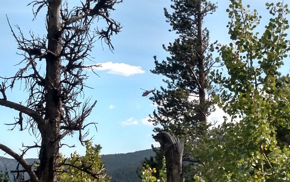
From the time I started hiking until I stopped here for lunch, I’d watched a number of helicopters fly overhead. At first, I thought there were two choppers sporting similar livery. The first two passes overhead were in the same direction: from roughly the direction of Allenspark and passing between Pagoda and Longs to go over Glacier Gorge. There may have been just the one helicopter and I missed its return trip. I didn’t know what they were up to. My first thought was that they were dealing with the Cameron Peak fire somehow, but they weren’t carrying a bucket or any other obvious cargo. They stopped flying over at about 11:00.
View to the east, roughly. A bit of smoke haze, but not bad.
I let the world go by for half an hour, ate my sandwich, drank my beer, and relaxed.
If I had brought a map with me, I probably would have tried an alternate route back. That would be everybody’s preferred route, which goes by Sandbeach Lake. Looking east, I’d stay out of the trees then head over the forested hump at the eastern end of Mount Orton, then descend to the lake. I’ll come back here again and give that route a shot.
I did stay out of the trees for a longer distance than on my way up. It was easy walking and I made good time. I kept thinking I should make my way to the creek but kept delaying it. I found a game and followed it. It snowed that fell last week, several inches of wet, heavy stuff. Sometimes it was hard to tell if it had been walked through or if it was just knocked down by the snow. I saw several places where it looked like elk had bedded down, but hadn’t seen any elk, deer, or moose all day. I finally did spot an elk for an instant: she heard me coming and ran away. I saw a flash of her backside as she fled through the trees.
Game trail through the grass
When I got to the end of this series of treeless gullies I found myself at the top of an outcropping I wasn’t willing to descend, so I had to backtrack a bit and find a route that didn’t bother me. I came across a talus field I spotted on the way up. It wasn’t the greatest route, but the rocks weren’t too big for me to make my way down.
Back in the woods I slowly worked my way to the creek. I came across a small pond I didn’t expect to find. It’s not on my map, but I did later find it on the satellite image. Back at the creek, I found an easy crossing and was back on ground I’d navigated before. I didn’t bother sticking too close to the creek. I can roam anywhere I want, as long as I head downhill. Eventually, I’ll run into the tributary I crossed when I left the climbers trail or I’d be back to Hunters Creek.
Staying away from the creek made for easier walking. The forest is sparse enough that there’s no deadfall to speak of and it’s late enough in the season that everything is dry. In July, I’d certainly be running into various trickles of water and marshy/grassy leas, and route finding would be more challenging. I shortly reached the tributary and crossed it to regain the climbers’ trail. I was only about fifty yards upstream of where I crossed on my way up.
I took a short break when I got back to the trail to Sandbeach Lake. I refilled my water bottle and ate the last of my fruit. I considered making the side trip to the lake, figuring it would take me an hour or a bit more. I was up for it physically, but I didn’t want to take more than an hour and figured it wasn’t worth making the trip if I couldn’t relax for a while at the lake. So I headed back to the car.
When I started hiking again, I heard another helicopter. I paid more attention to them now, noting the times they flew over and which direction they were going. They passed very close to the west side of Longs Peak. I’m sure anybody on the summit got a good look down on them.
The first flight of the afternoon was headed towards Glacier Gorge and it flew over me on its way back twenty minutes later. Twenty minutes after that, it was headed back to Glacier Gorge. This chopper made two round trips. Then a different one came from Glacier Gorge. It was a different model of aircraft, candy apple red instead of the orange and white of the earlier one. Instead of flying away, it descended into the valley below me. It took me a while to spot it through the trees. After a few minutes, it took off on its way back to Glacier Gorge. It made this trip twice.
The afternoon’s first helicopter
I made it back to the trailhead by 3:30. I was curious to know what the helicopters were up to. I’d have asked the ranger at the entrance station, had there been a ranger there. There was a group of motorcyclists there, taking a break and using the restrooms. So I asked the bikers if they knew anything. They hadn’t been there very long, and the red chopper never flew over here, stopping a bit west of Copeland Lake. They didn’t know anything about the choppers.
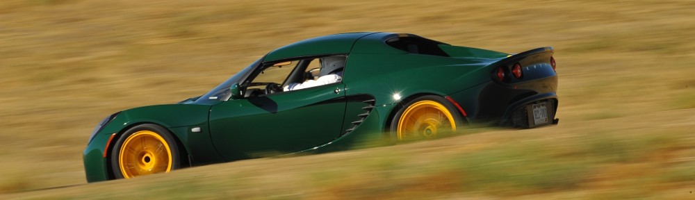
I was a bit surprised when one of them asked me what was on my hat. I’m always wearing my hat from Autobahn Country Club. The guy who asked was thinking my hat was from a track in New Jersey. I gave him points for knowing it was a track and told him it was Autobahn, in Illinois. He said he’d driven that track. I didn’t quiz him, but he did mention running laps at a few California tracks, so maybe he’s been to as many tracks as I have. I neglected to ask him whether he tracked a bike or a car.
He did ask me what I drove. He expressed surprise that I could fit in an Elise. And he was pretty well acquainted with Lotus. He asked if I’d “added any lightness” to it. “As a matter of fact, I have!” We chatted about track days for a bit.
It was another beautiful day in the neighborhood. I hiked about thirteen miles, climbing about 3100′. The weather was ideal. I saw only one person from 7:15 to 3:30 and didn’t see him until after 2:30. I’ve never had such solitude before. It doesn’t get much better than that.
Searching the news when I got home, I see that teams were out searching for a missing hiker. His car was found at the Glacier Gorge parking lot and he was assumed to be attempting the Glacier Gorge Traverse. That’s a “difficult 19 mile route” that crosses eleven summits. It seems they found his body today (Tuesday). The article I read says that they flew his body to a landing zone in Wild Basin. I can’t help but wonder if the article has the timing a bit wrong. Were they taking him out on the last helicopter I saw? How unfortunate. He was my son’s age.
Before I started this blog I had been posting trip reports to a forum for lovers of Rocky Mountain National Park. This is one of those reports, with only minor edits for clarity.
Hike date: 15 October 2011 — Originally posted: 16 October 2011 – 09:18 PM
My latest hike was to Castle Lake. I went Saturday (10/15) and the weather was fabulous. To get to Castle Lake, the Foster guide says to go to Lion Lake #1 and contour around a prominent bench. I was thinking it should be pretty easy to get to Castle Lake by striking northeast from the trail, rather than going all the way to Lion Lake #1. Without GPS it’s not that simple. Although the lake is only 500-600 feet from the trail, there’s just no way to know where to leave the trail unless you’ve been there before. This is another lake I could easily imagine hasn’t been visited before. No trail, no cairns.
Castle Lake has no inlet streams and no outlet stream. At this time of year, the water level is quite low. It has also begun to ice over, even though it hasn’t been particularly cold yet. There is some snow on the ground – I first came across it on the trail at perhaps 10,000 feet. Seldom more than a few inches deep it didn’t cause any navigational issues. At the lake, I found a few “drifts” that were perhaps a foot deep. I didn’t see any large wildlife, but I did follow some deer tracks through the snow on my way back to the trail.
This time I carried a small GoPro HD video camera with me. Turns out it’s not a particularly good tool for landscape photography, as it has a very wide angle lens. The only useable footage was when I played with the time lapse feature while I was eating my lunch. Here’s 22 minutes compressed to 22 seconds:
This was only my second time up the Lion Lake trail. I really like this trail, at least the part from the Thunder Lake trail to Lion Lake. The forest isn’t dense, so you sometimes get glimpses of the surrounding mountains. Very pretty.
Leading up to this hike, I was telling myself that I only need to visit two more lakes in Wild Basin and I’ll have been to them all. I was thinking I only needed to go to Junco Lake and Isolation Lake and I’d “have the set.” I was a bit off. In addition to those two, I also have yet to hike to Frigid Lake and Indigo Pond. In any event, my goal for this next hike was to get to Junco Lake.
Originally, Chad was going to go with me but his plans changed. We were going to meet Bob at the trailhead. Bob wouldn’t go with us, but would accompany us the first few miles. But I didn’t properly communicate where Bob was to us me and we didn’t connect. I waited a few minutes past our appointed rendezvous for him then hit the trail. I discovered later that he was there, just at the wrong trailhead. Entirely my fault.
Anyway, to get to Junco Lake we will essentially start with Bluebird Lake. The hike to Bluebird Lake has a lot to offer. It has three notable water features: Copeland Falls, Calypso Cascades, and Ouzel Falls. Then there are the open views where the trail goes along the top of a ridge that was burned by the Ouzel fire back in ’78. And the last three times I’ve hiked to Bluebird, other hikers have said they’ve spotted moose. I never can find them, but that’s just my luck.
Just above Ouzel Lake the trail passes through some talus and with no trees there, it’s an ideal place for raspberries. There are a number of stretches where raspberries grow in abundance. I couldn’t resist tasting a few. The berries may have been small, but they were delicious. The leaves were starting to turn dark, and there were no immature berries. The plants are much smaller than the ones in my back yard. But the weight of fruit as a percentage of the total weight of the plant is much higher. These little plants were densely covered with the sweet little tasty morsels.
A little farther up the trail I came across a couple who had passed me on the trail a bit earlier. Looked like they were picking berries, but there were no raspberries here. “We found huckleberries!” I’m sure I’ve had a slice of huckleberry pie, but I could certainly never identify them in the wild. These were growing on very small plants, close to the ground. Most of the berries were red, about as red as a not-quite-ripe raspberry. “You want the purple ones.” They were quite tiny, not much bigger than a BB but quite tasty.
The steepest part of the trail below Bluebird Lake is also quite lovely. The hillside is covered with an avalanche of wildflowers. I was thinking it might be a bit late in the season, but here the flowers were still quite vibrant.
I was pleased with my progress thus far, reaching Bluebird in a few minutes over three hours. It’s less than a mile from Bluebird to Junco, but there’s no trail and about a 750′ climb.
The Foster guide says to go around the base of the ridge and follow the stream. The last few times I went to Bluebird I spent some time studying the terrain and was never happy that that was the way to go. So I asked around. Kristin sent me a couple of pictures with two suggested routes. Each looked to be better than Foster’s suggestion.
So, without taking a break here, I headed up the ridge to Junco. It was easy enough to start, there are all sorts of grassy ramps and shallow gullies. But before long I managed to get to a spot that I didn’t like and backtracked a little. Then I ran into the couple I shared huckleberries with. I followed them for a bit, until they went down a section that made me uncomfortable. I let them go their way; I headed to the top of the ridge. Kristin told me it would be easier up top and I think she was correct.
I made it to Junco pretty much at the same time as the Huckleberries. I made my way to a comfy spot near the outlet and tucked in to my picnic. The wasn’t a cloud in the sky, but there was a faint haze from wildfires half a continent away. I brought the GoPro with me but didn’t bother setting it up as, without clouds, there’s no point in trying to do a time lapse video. Meanwhile, the Huckleberries had changed into their swim suits. She did a bit of sunbathing but he took a dip in the lake. I put my soda can in the water for a few minutes so I’d have a cold drink.
Ouzel Peak and Junco Lake
I headed back down after a half hour break. Having told myself that I’d be better off staying on the top of the ridge, I found myself heading down one of the many grassy ramps. It started off well enough but soon had me in a spot I didn’t like at all. I backtracked and chose another ramp. Again, no joy. As I was backtracking the second time, I ran into the Huckleberries again. I followed them for a good while, but they were moving faster than me and soon were out of sight. But by then I was pretty sure we were retracing the route we used on the way up.
Mahana Peak, Bluebird Lake. Longs and Meeker in background.
I took another break at Bluebird – snacked on my peach and slathered on another coat of SPF. At the Upper Ouzel campsite the trail crosses the outlet from Bluebird. I refilled my water here. By the time I was back to the car, I’d used up all the water. That’s the flip side of the open views in the burn area – there’s no shade and I feel a little broiled in the afternoon sun. I drank as much water in the last five and a half miles as I did in the first nine.
It was a full day, and by the time I made it back to the car I was exhausted. The Foster guide tells me it’s 7.2 miles from the trailhead to Junco Lake, with a 3,210′ net elevation gain. I’m guessing that with my backtracking I didn’t add much distance but did add a non-trivial amount of elevation. The hike was not only physically challenging, but I’ll admit to more than the usual difficulty route finding.
Denver’s forecast for Sunday was mid-80’s and clear. It sounded like ideal weather for one last hike above treeline. The goal this time was Isolation Lake. I’d been leaving my options open; there are two lakes above Bluebird Lake that I’ve never been to. Junco Lake is about a mile, across terrain I’ve not gotten a good look at. Isolation Lake is at 12,000′, accessed via a bit over a mile of open tundra. I was undecided which I’d visit until I got to the Park.
I wanted to be on the trail about 7:30. I wasn’t sure how long it would take me to get to Bluebird. It’s 6.3 miles, with the last mile fairly steep. I figured the stretch between Bluebird and Isolation would take an hour, so I wanted to be to Bluebird by eleven. I was between Boulder and Lyons for sunrise. Not a cloud in the sky. The drive all the way to the Park was pleasant – there was almost no traffic.
At the trailhead I snagged an end spot. The lot was perhaps a third full. Somehow I got the idea that the bridge had been repaired at Ouzel Falls, but they had signs up saying it was still out. I could try that way on the hike out, as it would only cost me a mile or so if I had to turn around.
Above Copeland Falls they’re nearly done with significant repairs to the trail, damaged two years ago. With the bridge out, I had to take the campsite route to the Thunder Lake trail. I’d been calling it an unimproved trail, but the bridge out sign called it “primitive”. It’s your basic forest trail that gains about seven hundred feet of elevation.
The trail to Ouzel Lake follows the spine of a ridge that was burned in the Ouzel fire in 1978. It’s like a big eraser went through there, removing a strip mature forest a half mile wide and several miles long. This time of year you get a better sense of how much of this strip has been filled in by aspen, the only aspen visible south of the St. Vrain. This section of trail is exposed to the wind and sun. The sun was shining brightly in a clear, deep blue sky. On a July or August afternoon this would be a fierce sun but this morning was quite pleasant. It wasn’t calm, just a light breeze.
Before exiting the burn scar and returning to the forest we pass just above Chickadee Pond and Ouzel Lake to the south. The trail makes climbs a quick four hundred feet, flattens out to cross a talus field, then climbs another four hundred. In this second climb I chatted with a hiker on his way down. “Did you spend the night up here?” “No, thank God. The wind is bad, maybe sixty miles an hour.”
That was a bit discouraging. From Bluebird to Isolation is open tundra, so I’d be hiking into the teeth of the wind. I can assume I might find a big rock to use as a wind break when I got to Isolation, but don’t really know. While it is probably quite pleasant to sit at 12,000′ in bright sunshine and calm, with any sort of wind it will be cold.
When I got to Bluebird I didn’t even take a picture. The wind was fierce. Maybe not sixty but easily forty miles an hour. I took one look in the general direction of my goal and turned around. Although the hike to Junco is more sheltered, the wind wouldn’t be any better. So Plan B is picnic at Ouzel.
Rather than go back to the trail junction, I bushwhacked the hundred yards or so from the Bluebird Lake trail, going between Chickadee Pond and Ouzel Lake. It’s a forest lake, without an abundance of rocks. I tried to find a spot on a rock, in the sun, out of the wind, close to the water. Today, no such place existed. I did find a spot in the shade, slightly protected from the wind. I didn’t set up for a time lapse as there still wasn’t a cloud in the sky.
Below Ouzel Lake I ran into a guy coming up. “Boy, am I glad to see you and this trail!” He didn’t see the bridge out sign at the trailhead and made his way to Ouzel Falls. He went upstream on game trails until he found a spot to cross, but went a long way before regaining the trail. There was no point in heading to Ouzel Falls now that the missing bridge was confirmed. Ouzel Falls is only a nice spot for a break if you’re on the other side of the river.
I took another break on a rock outcropping on the campsite cutoff. Even so, with the shortened hike and abbreviated picnic, I was back to the car by 2:30. Traffic was not nearly as bad as I expected. I assumed lots of people would be driving around viewing the aspen. There was some of that; lots of convertibles and even a couple of early sixties British sports cars. But not heavy traffic, and everybody managed to go as fast as the speed limit for the most part. That is, until reaching Boulder where a biker raced to get to the front of the line then proceeded to putt along at twenty under the limit.
The hike itself was quite pleasant. Once away from the lake, even on the exposed ridge, there was no wind to speak of. And I didn’t see a cloud in the sky the entire day. I didn’t bag a new lake today, but that’s okay. I can pencil another attempt at Isolation on the calendar for next August.
Cony Lake sits lies at the upper end of the Cony Creek drainage, south of Mount Copeland at the southern edge of the Park. Starting at the Finch Lake trailhead, it’s a 9.2 mile hike climbing over 3,000 feet. If you start at the Allenspark trailhead instead, you save a mile each way and five hundred feet of elevation.
Two years ago I made it as far as Pear Lake. I took a break there to eat some fruit. After the break I hiked up the bench to the south where I came across a pond. Here I realized I’d abandoned the camera at Pear Lake, so I had to turn around. It was just as well – clouds rolled in from the east, just feet above the lake. Last year I got as far as Upper Hutcheson Lake. I struggled through a mass of willow only to see snow covered slopes on the other side of the lake. Between my lack of spikes in mid-July and losing time in the willow, it was an easy decision to stop there.
Third time’s a charm, right? Saving eleven percent of the distance and fifteen percent of the climb will make it easier. I’m going nearly a month later in the season this time, and I have a better idea of the lay of the land. I felt good about my prospects.
We’ve been having hot, clear weather lately but Saturday’s weather forecast degraded every day all week. It would be cool with a good chance for rain. I hit the road at 5:30, planning to be on the trail by 7:00. Low clouds obscured all the peaks. Meeker, Longs, and Pagoda were mostly clear, but everything to the south was in a layer of clouds with a ceiling not far above treeline. Above that, blue skies to the west and a layer of high clouds to the east.
This was my first visit to the Allenspark trailhead. I couldn’t see the parking lot on the satellite images, so I wasn’t sure if I’d be able to park. It’s a bit over a mile up a dirt road and if I couldn’t park there I’d have to use the Finch Lake trailhead. There’s room for a dozen cars in the trees, but the entrance has a giant rut. I pondered for a second and gave it a try. It was sketchy, but I made it in without scraping bottom.
I was on schedule: on the trail promptly at seven. Another solo hiker arrived in the parking lot after me; he passed me on the trail before I’d done a mile. I asked him where he was headed. He said “Pear for sure, maybe a bit farther.” I told him I was headed to Cony. He said perhaps we’d see each other again, but he was moving at a much quicker pace than I was managing.
From the trailhead to the Finch Lake trail junction just below the Ouzel burn scar is 1.8 miles. It’s been nearly forty years since the fire. It’s no longer an area of dead sentinels and wildflowers. The new trees are getting bigger, but it’s not forest yet so the spectacular view is relatively unobscured.
There were very few other hikers. In the six miles to Pear Lake, I ran into eight or ten folks hiking out and a few more who were still at the Pear Creek campsite. I did catch up to the other hiker, Jason, between Finch and Pear. He put the afterburners on after his break and he was quickly out of sight.
A cacophony of wildflowers
Foster says, at Pear Lake “follow the unimproved but recognizable trail”. The first time I tried Cony, I went on the other side of the lake. The second, I followed the trail along the shore until it faded out, then headed up. I was thinking this was the unimproved but recognizable trail. I found out on the way back that I wasn’t even close. Anyway, I’d been here before so it was no trouble to find Lower Hutcheson Lake.
According to Foster’s map, the route is to cross Cony Creek just above the lower lake, then recross at the outlet of the middle lake. The crossing at the lower lake was easy – the stream has split into two narrower channels. Up slope a ways I found myself blocked by krummholz and willow. After squeezing through one gap I noticed my water bottle was missing. It must have fallen out right here.
But no. A thorough search yielded nothing. Clearly, I lost it earlier. I made my way back down, not exactly sure how I’d come up. I think I was backtracking correctly, but did I go on this side of this clump of bushes, or that side? Shortly before I was back to where I crossed the second portion of the creek I saw Jason on the opposite hillside. I hollered at him to hold up.
I made my way over to him, told him I’d lost my water. I’d have to turn back with no water. He kindly gave me a liter of water. He was going to keep going for a while so I got out my map for us to consult. I have it marked with Foster’s route. I told him I’d look for my water bottle a little while longer before giving up. I found it almost immediately, sitting on the bank of the creek.
Following Foster’s route we found ourselves back where was when I realized I’d lost my water. It didn’t take long for us to decide to switch back to the north side of the creek. A couple minutes after crossing we found a nice trail. This dumped us on to a series of rock slabs. We were able to follow a few cairns, but that was it. From here, it’s a good idea to climb upslope a bit to avoid the krummholz and willow. Above the middle lake, Jason called it quits. He’d told his wive he’d be back at a specific time, and this was all the farther he could go.
I had no fun in the willow along the north shore of Upper Hutcheson last year, so I decided I’d stay higher up on the slope and avoid it. Foster’s route was on the south shore, but her route below was wrong and I no longer trusted it. So off I went, climbing slowly but steadily up the slope of Mount Copeland as I worked my way west. It didn’t take long to realize I still had quite a way to climb to avoid the krummholz. I paused to assessed the situation.
The north shore is a longer route than the south shore, as I’d need to go south to get to Cony. There was much less willow on the south; it looked like I could go right along the water and avoid it. If I went straight downslope where I was, it was a pretty easy route. The willow weren’t too thick there.
On the south shore, at this time of year with the water low, it looked like I could hop across the rocks right at the waters edge and avoid the bushes. It almost worked – I made it quite a distance but right at the end the rocks were too far apart, and the water had gone from a few inches deep to well over boot height. So, another short backtrack.
I finally find myself at the south western end of Upper Hutcheson Lake, just a few tenths of a mile away, at the top of a four hundred feet climb. I find myself at the base of a vast sea of willow. I either have to backtrack to go over the outcropping on my left or wade through the willow. It’s 11:30. I clearly won’t make Cony by noon. The sky is blue to the west, but some of the clouds to the east might drop some rain. I decide to abort the assault on Cony Lake and have my picnic here.
I haven’t replaced the tripod yet, but I did remember to bring the shutter timer this time. I found a nice rock to use as a base and set the camera. I faced a bit of a dilemma. To the west, small clouds were coming over the divide then boiling away but the foreground not interesting. To the east the clouds were higher and slower moving and the lake is in the foreground, Too bad I only had the one camera.
It was cool and windy. I was in sunlight for the most part but had little shelter from the wind. I sat in the lee of a small boulder and ate while the camera clicked away. After a short while I realized I didn’t hear the camera shutter. Was I too far, was the wind blowing the sound away from me? No, the camera had stopped with “Err 99”. I’ve had this happen occasionally. Just turn it off and back on and it’s cleared. It ran only for a few more minutes before getting the error again.
After restarting it the second time, I started to have second thoughts as to what I should be shooting. I let it run a while longer before switching it to the west. Then, of course, those clouds seemed to be going away. Have I made a mistake? Ah, well. You never know what you’re going to get.
Taking an hour break gives you a lot of time to take in the surroundings. It was windy and the nearby willows not so much rustled as hissed, at times almost loud enough to drown out the sound of falling water. I wasn’t hearing the inlet in the willows but a waterfall on the canyon wall two hundred feet up. There was quite a bit of water coming down but the talus twenty feet below the bottom of the falls was dry. From the looks of it, it’s always dry, even in max flow.
The windbreaker was beginning to feel inadequate after an hour of lounging. It was time to pack up and get moving again. My next navigational problem was getting back to the other side of the creek. I wanted to avoid the willow as much as possible. Perhaps Foster’s route here on the south side was correct after all. Being above the landscape gives a much different perspective on things than being in the landscape, looking up.
There’s a small pond below the upper lake. With water levels so low, it’s easy to skirt the southern shore to a nice crossing to a grassy slope on the other side. Easy, peasy.
It was here that I started to reflect on the day so far. I lost my water bottle and had to backtrack to retrieve it. I made a few navigational errors and I didn’t achieve my objective. Instead, I sat at the edge of a beautiful alpine lake for an hour and watched the world go by. Okay, the camera futzed out a couple of times. But all in all, there’s nothing to complain about. It’s just another beautiful day in the neighborhood.
Above Pear Lake I managed to stumble upon the trail Foster mentions. It’s quite well defined here and going is easy. I soon see Pear Lake below me – I’m well above the shore. And yet the trail refuses to descend. How can this trail not go down to the lake? I cut cross-country. About halfway from the trail to the shore I come across a nice outcropping of rocks with a view and decide it’s time to take a break.
It’s peach season. Lots of people think of Georgia when they think of peaches, but I think the best peaches are grown on the western slope of Colorado. I have one of these Palisades peaches with me. This particular example is top rate: perfectly ripe and perfectly juicy; sweet and full of flavor. I always say food tastes better at alpine lakes, but this peach would be one of the finest peaches ever, even in my kitchen.
So I’m luxuriating in this wonderful peach, enjoying the now clear and brilliant blue skies above. What could be better than this? As I’m eating the peach, I spot an eagle soaring over the lake, fishing. She circled a few times then dove. The water erupted in a big splash and momentarily she arose, the silver of a fish clearly evident in her claws. Then she made a couple of wide circles above the lake, as if to show off her kill, before heading to the trees on the other side.
Bear left for Hutcheson
Break over, I got back on the move. There’s a hitching post where the trail arrives at the lake. It’s here that you get the trail to Hutcheson Lakes. This is the trail I was just on. I walked right by it at least twice without figuring it out.
My next stop was the stream crossing at the Pear Creek campsite. I needed to replenish the water supply. Not ten steps on the other side of the creek I stumbled over a rock on the trail. I do this countless times each hike; it’s never a big deal, I never lose my balance. This time I “went over the handlebars” as Michael might say. My left foot slipped, I went down on my left knee and put my hands out to stop my fall. My left hand slipped as well and I ended up on my elbow. This resulted in an ugly abrasion on my left forearm.
It stung, and it was bloody. At least the stream was right there. I had it washed off in no time and used one of my paper towels to stanch the flow. I basically lost the skin along the bony part of the forearm – five or six inches long and a quarter inch wide. I took a couple of ibuprofen and was back under locomotion ten minutes later.
Most of the day I’d been shrugging off all the minor mishaps – I was having a great time in spite of losing my water bottle, the camera acting flaky, minor navigational issues. I’m in a beautiful place and it’s hard not to enjoy it. But the gods wanted to test my limits and had that rock grab my toe.
Chief’s Head and Pagoda. From left to right, see the chief’s forehead, nose, and chin. Pagoda would be his pointy bra.
I was back to the car by 5:20. Turns out there are two entrances to the parking lot; the southern one lacks obstacles and I was out without any additional drama. Even though it was nice and sunny, it wasn’t hot so I headed down the road topless. Traffic wasn’t bad and it was a pleasant drive home.
A couple weeks ago I met Gale on the trail to Lawn Lake and we exchanged emails. This week, she asked if she could tag along, if I was planning on a hike on Sunday. Well, I had no plans when she asked but that was easy to remedy.
A couple years ago I followed Foster’s directions in an attempt to find Twin Lakes in Wild Basin. She says “finding these lakes is a bit of an orienteering challenge”. I fell short of that challenge and figured it was about time I made a second attempt. I studied the map for a while, finally suggesting that Gale accompany me on my second assault. Over three or four days, my plan evolved a few times with my final idea being after we visit Twin Lakes, we cross the ridge, bushwhack up to Sandbeach Lake and hike out on that trail.
We met at the Sandbeach Lake trailhead shortly after eight. I left my car there and she drove us to the Thunder Lake trailhead. We put boots on the trail before eight thirty. It was sunny and mostly clear; the only clouds were hanging over the Divide. It was also windy. I think I used the phrase “a bit breezy.” What I really meant was more like “it was savagely windy.” But the hike would be through forest the whole way; the only time I expected to deal with the wind was when we were hanging out at the lakes.
Rather than follow Foster’s directions this time, my plan was to hike up the Thunder Lake trail until we reached about 9800′ elevation, then contour east along the slope to the lakes. I’m generally low tech when I’m hiking. I don’t carry a GPS unit with me. I do carry a smart phone, though. I use a speedometer app when I’m in the car because the car can’t be trusted to tell me how fast I’m going. This app also shows the elevation, which can be handy in cases like this.
Shortly after regaining the main trail after the campground shortcut, we arrived at a couple of switchbacks. The eastern end of one of these was conveniently close to our target elevation so we headed off trail there. As is usual when off trail, we couldn’t go in a straight line. I kept thinking we were going downhill, but every time I checked our elevation we were still on target. It was in here I saw the only wildlife on the hike: I spooked a very large rabbit who made very good speed in spite of his girth.
We weren’t making great time, what with finding the best route past rock outcrops or through dense pockets of trees. But it didn’t take too long to arrive at the larger of the Twin Lakes. This is the westernmost, larger one. These lakes are snow fed, neither has an inlet or outlet stream. They’re pretty shallow and, again, I’ve been to larger unnamed ponds in the park. But the view to the west from this lake was very nice. As expected, the wind was quite strong here. At times the wind gusts were so strong they kicked spray up ten or fifteen feet above the water.
We found a place more or less out of the wind and I set up the SLR to do the time lapse. We sat and ate part of our lunches and watched the world go by for about a half hour. Upon retrieving the camera I saw that I neglected to use my usual settings. There are a number of things I have to change from my usual shooting – turn off auto-focus, turn off stability, set it on full manual and set the proper exposure, configure the timer. And change it from storing raw images with large, fine JPG to a smaller image. This is the first time I’ve managed to forget this part. So I filled the memory card pretty quickly. Oops. I’ve been meaning to buy a bigger card; perhaps this error will be the impetus for me to get it done.
After getting our gear together, we headed the short distance to the other Twin Lake. It’s just a few yards away, and up a few feet of elevation. We passed through a little aspen grove. This one turned out to be perhaps the most interesting aspen grove I’ve walked through. Some beaver had been busy here, gnawing through dozens of trees. Some had been downed, chewed through completely. Others were still works in progress. The wood chips looked fairly fresh; I doubt this work was abandoned, but what do I know?
I didn’t see anything like a beaver lodge in either lake, and there are no streams here. The beaver must be in one of the lakes, though. These were pretty big trees; there was no other possible body of water this lumber could be taken to, unless that beaver has access to a helicopter or something. Which probably means I wouldn’t recognize a beaver lodge if I was standing on it.
There is almost no view at the smaller of the two lakes, so we didn’t dally there long. From here, we headed almost straight up slope. We only needed to gain about two hundred feet to top the ridge. We passed a couple of cairns and came across what I think is a wildlife trail. After topping the ridge, a small unnamed pond was next, just below us. The pond sits, as is common, surrounded by marshy grass. Being nearly November, it was mostly dried out.
Sandbeach Creek feeds this pond. The map also shows a gully a bit to the west of the creek. We found ourselves ascending this gully rather than the creek. The gully is clearly a flowing stream during spring and summer; now it’s dry but verdant, filled with moss covered rocks, darkly green in the shade of the forest. In places, it looks like there is dried mud covering some of the rocks. It’s not mud, but a dried fibrous sheet a couple millimeters thick.
The gully opened into a clearing where we hopped up a pile of rocks about thirty feet high before returning to another mossy section. Here I decided we needed to head a bit more towards the east. “Just over this next rise we’ll find the lake.” It wasn’t the first time I said it, but I was finally correct. We emerged on the shore of Sandbeach Lake just a few yards to the west of the outlet stream.
It was calm here on the lee shore. It was also mostly devoid of an interesting view, so we circled counter clockwise toward the trail. The wind was quite intense on the east side of the lake. And because this used to be a reservoir like Lawn Lake, there aren’t any trees along the shore to provide shelter. We retreated into the forest, found a nice rock to sit on, and ate more of our lunches. I decided not to set up either camera as I figured neither would be able to sit still in this wind. So it goes. It’s unlikely I have enough footage to bother with a video this time.
There were a few other hikers there. We talked to two guys who spent the night there. They had heard there was an alternate route back to the trailhead. I got my map out and showed them a route I considered for this hike. And, as we no longer needed it, I gave them the map.
The hike out was uneventful. The wind seemed to be dying down a bit, and the skies remained clear overhead. Crossing Hunters Creek, I wondered if there was a bridge there that was washed away last September. There are just sawn logs there now. Perhaps I’m just misremembering. We arrived at my car a few minutes before three, still feeling fresh and in agreement that it was a fun hike. The off trail excursion was pleasant and the beaver activity at the lakes was unusual and quite interesting.
On a final note… I regularly wonder how often my car shows up on Instagram or Facebook. People are always taking pictures when I’m at stop lights or in parking lots. This evening, my son found my car on Facebook. It’s a picture taken today, at the trailhead. Too funny.