Robert Browning once said, “Ah, but a man’s reach should exceed his grasp, or what’s a heaven for?” We should aim high: there is value in attempting that which, in the end, may be impossible.
Today, we have (yet another) case where my reach exceeded my grasp. I had every intention of hiking to the summit of Mount Orton, but I succeeded only in reaching Sandbeach Lake. In times past, I’d have titled this post “Mount Orton FAIL”. I’m beginning to concentrate more on what I do than on what I fail to do. I think it’s important to have goals, even if we sometimes fail to attain them.
The plan was to climb (walk up, really) Mount Orton from Sandbeach Lake. Depending on whose numbers you use, Sandbeach Lake is 4.2 or 4.5 miles from the trailhead with an elevation gain of about 1,950′. From the lake to the summit is an additional 1.5 miles and 1,450′, and that’s off-trail. From the lake to the summit, then, should be less strenuous than the Manitou Incline, if you ignore the fact that you don’t have to hike four and a half miles before you start the incline.
There’s road construction on highway 7 that affects traffic starting at 7 am. With that in mind, I planned to arrive at the trailhead by around 7, which should get me to the lake by 9:30 or so, allowing me to take two hours to reach the summit and not worry too much about afternoon thundershowers. I felt it was a good plan.
Digression #1: Trail History
Many of the trails in the Park have been entered into the National Register of Historic Places. From my reading, most of the trails on the west side of the Park were developed with recreation in mind, with the routes scouted by and initial construction done by operators of Grand Lake hotels. The Sandbeach Lake trail, however, was initially a purely commercial endeavor.
Many lakes in Wild Basin were enlarged by building earthen berms. The extra water capacity was intended for use by farmers and ranchers around Fort Collins, Loveland, and Longmont. Off the top of my head, I count Bluebird, Box and Eagle, Pear, and Sandbeach. Also on the list, but not in Wild Basin, is Lawn Lake.
In the early 1900s, “the Supply Reservoir Company filed upon Sandbeach Lake, intending to make the natural lake into a reservoir.” That language isn’t very clear to me, but we can see that an earthen dam was built at Sandbeach Lake. From what remains of the dam, it appears that it raised the water level by perhaps twenty feet.
Much of the current hiking trail to the lake was originally a road that was built for the construction and/or maintenance of the dam. The company built a road from the Peak to Peak highway near Meeker Park that headed west. The current trail starts near Copeland Lake. The first section, to the junction with the Meeker Park trail, was not part of the road.
The application for the National Register (which I will just call “the application”) says, “Contemporary maps indicate that the road deteriorated over time. By 1917, it was designated one of the ‘poor automobile roads.’ Meanwhile, hikers and horseback riders discovered the route, effectively turning the old road into a tourist trail. In 1915, Rocky Mountain National Park’s first superintendent listed the pathway among the new park’s trail assets.”
Hiking the trail today, it’s easy to imagine a team of horses (or mules or oxen?) pulling a wagon over several significant sections of trail. The trail crosses Campers Creek and Hunters Creek and both crossings are wide, shallow fords easily passable by a modern 2-wheel-drive SUV. On the other hand, there are long stretches where I can’t imagine even a primitive road ever existed.
The application makes no mention of the only other bit of Sandbeach Lake history that I knew: the visit by John Wesley Powell. On his expedition to the area in 1868, the party camped at Sandbeach. While they were there, one of the party, a chap named Keplinger, explored the terrain up Hunters Creek and found the route the group took on the first-ever recorded summiting of Longs Peak.
Digression #2: Pondering Dam Building
Seeing where the trail could easily have been a road and seeing where the existence of a road challenges the imagination, I couldn’t help but wonder what sort of traffic, and for how long, this road needed to support.
It seems to me that that’s all determined by the construction of the dam. The dam was an earthen berm perhaps twenty feet high. I didn’t closely inspect what’s left of it on this trip, but I imagine that without modern earth-moving equipment, it would have been a non-trivial amount of work. Presumably, there would have been some sort of flood gate or valve installed about where the natural outlet was, and a spillway would have been created. The berm is fairly wide and at least a couple of hundred feet long.
How big of a crew did the work, and what sorts of tools did they employ? All this had to navigate the road. Was it done by truck or by wagon? I would think that, for the duration of the construction, the road would have seen regular use and have been what I’d call fairly “well-engineered”. However, I see little sign of engineering. There are no retaining walls or the like. The Park’s application includes the statement “Log bogwalks support the tread through flat, swampy areas. Some bogwalks look old, decomposing into the ground that they retain.” This application was written in 2007, and today I don’t see any bogwalks at all. So it doesn’t take long for things to change.
So, by 1917, the road had fallen into disuse and been claimed by hikers.
Digression #3: The Fate of the Reservoir
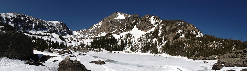
Looking at Sandbeach Lake today, it’s fairly obvious how much higher the water level was when it was enlarged. The trees between the current water level and the old level look to be about as mature as the trees that have grown back where the Ouzel fire burned back in 1978.
So when was the reservoir removed? The answer lies in the Lawn Lake flood of 1982. After that flood, the park began the process to remove some of the dams built around the turn of the twentieth century. In 1988, they removed the rock and dirt dams at Sandbeach and Pear Lakes. The shorelines were regraded to the original slope and the shores have been allowed to restore naturally with a minimum of supplemental planting, although they did plant willows around the Sandbeach outlet to create spawning habitat for greenback cutthroat trout. (In 1989 and 1990, five million pounds of concrete and rebar were removed from the Bluebird Lake dam and flown out of the backcountry. It boggles my mind to think of how so much material was emplaced at Bluebird in the first place.)
Wednesday, June 29
I can’t help but note that there are signs at the Wild Bain entrance station stating that timed-entry passes are required for visits starting at 9 am. It also seems to me that they don’t have any rangers working at the entrance station. I’m guessing the passes aren’t enforced in Wild Basin. Not that it matters that much: if you don’t get there well before 9, you won’t find a place to park.
Just as soon as I got out of the car, I heard some crashing in the undergrowth nearby: a cow moose was making her way through the area. I find it amusing that I often see a moose within twenty yards of my car and I can hike for hours and not see one in the backcountry.
I was early enough that I didn’t encounter too many hikers on the trail. I ran across two guys hiking out. They weren’t walking together, but I assumed they were together. I chatted with the second one. I told him I intended to summit Orton and that got him talking. He asked if I’d ever been to Ellington Lake. I told him I’d day-hiked to every lake in Wild Basin except Isolation and Frigid but that I’d never heard of Ellington Lake. He told me I wouldn’t be able to get there, as I had insufficient gear with me. It wasn’t until a few moments after parting ways that I figured out what he was talking about: Keplinger. Three syllables, same second syllable, same vowel sound in the first syllable. And in June, the lake would still be well frozen over and much snow would have to be crossed to reach it.
By the time I reached the lake at 9:17, pretty much spot-on my schedule, it was growing clear to me that I wouldn’t get to where I wanted to go. I’ll admit that the weather-related aspect of my hike planning goes something like this: “Well, it’s going to be 95 degrees in Denver. Sounds like a good day to hit the high country!” This is generally not a bad plan. But today it didn’t work out for me.
I was dressed in shorts and an aloha shirt. The only extra layer I brought was a thin waterproof shell. Instead of bright sunshine and warm temperatures, there was a large darkish cloud hanging over the Divide: sunshine well to the west; thin, high clouds over the plains. And it was a bit breezy. It seemed to me that the clouds were dark enough that they might produce some rain. I would likely be miserable above treeline.
I made a half-hearted attempt to start bushwhacking my way up the slope but abandoned it pretty quickly. I had made little attempt to find anything like a trail that might lead up the mountain but after I turned around I stumbled on a trail that might do the trick. I may not be able to walk right up to that trail next time I want to do this, but knowing that it’s there is enough, and I’m sure I’ll find it when the time comes.


In the end, I stayed at the lake for nearly two hours. I’m surprised I lasted that long. I found a nice rock on the shore with a nice view of Mt. Meeker, Longs Peak, and Pagoda, but with the cloud cover and wind, I really didn’t want to sit there. I could almost get out of the wind by hanging out in the nearby trees, and I walked around a bit, up to the old reservoir shoreline to check out the wind-gnarled trees. I didn’t want to eat lunch yet, as it was still early. I ended up stopping at Hunters Creek for my lunch.
When I made the decision to stay at the lake, I was feeling a bit disappointed with myself. “Don’t be such a wimp! You can make it, don’t be so lazy!” By the time I ate lunch, my attitude had changed. I was cold at the lake, where I could find at least a little shelter from the breeze. Another 1500′ up, above treeline, I’m sure I’d have been miserable. I think I’d have made a more sincere effort to continue if I’d have found the trail, but I’m convinced I made a sound choice to stop. I didn’t see my shadow between about 8 am and when I got back to Lyons.
I’m not sure I’ll make another stab at Mt Orton as a day hike. I think it’s within my range, but I’ll admit to beginning to think that my range probably isn’t what it was a few years ago. In my wanderings around the east shore of the lake, I took a good look at the campsite there. It’s one of the nicer ones I’ve visited. The privy even has walls! This looks like a good place to spend a night and making an early assault on the summit.
Thank you for sharing the history of this lake. I’ve hiked to it and vaguely knew it used to be a reservoir. I enjoyed learning all the rest!