Sunday, October 26
A couple weeks ago I met Gale on the trail to Lawn Lake and we exchanged emails. This week, she asked if she could tag along, if I was planning on a hike on Sunday. Well, I had no plans when she asked but that was easy to remedy.
A couple years ago I followed Foster’s directions in an attempt to find Twin Lakes in Wild Basin. She says “finding these lakes is a bit of an orienteering challenge”. I fell short of that challenge and figured it was about time I made a second attempt. I studied the map for a while, finally suggesting that Gale accompany me on my second assault. Over three or four days, my plan evolved a few times with my final idea being after we visit Twin Lakes, we cross the ridge, bushwhack up to Sandbeach Lake and hike out on that trail.
We met at the Sandbeach Lake trailhead shortly after eight. I left my car there and she drove us to the Thunder Lake trailhead. We put boots on the trail before eight thirty. It was sunny and mostly clear; the only clouds were hanging over the Divide. It was also windy. I think I used the phrase “a bit breezy.” What I really meant was more like “it was savagely windy.” But the hike would be through forest the whole way; the only time I expected to deal with the wind was when we were hanging out at the lakes.
Rather than follow Foster’s directions this time, my plan was to hike up the Thunder Lake trail until we reached about 9800′ elevation, then contour east along the slope to the lakes. I’m generally low tech when I’m hiking. I don’t carry a GPS unit with me. I do carry a smart phone, though. I use a speedometer app when I’m in the car because the car can’t be trusted to tell me how fast I’m going. This app also shows the elevation, which can be handy in cases like this.
Shortly after regaining the main trail after the campground shortcut, we arrived at a couple of switchbacks. The eastern end of one of these was conveniently close to our target elevation so we headed off trail there. As is usual when off trail, we couldn’t go in a straight line. I kept thinking we were going downhill, but every time I checked our elevation we were still on target. It was in here I saw the only wildlife on the hike: I spooked a very large rabbit who made very good speed in spite of his girth.
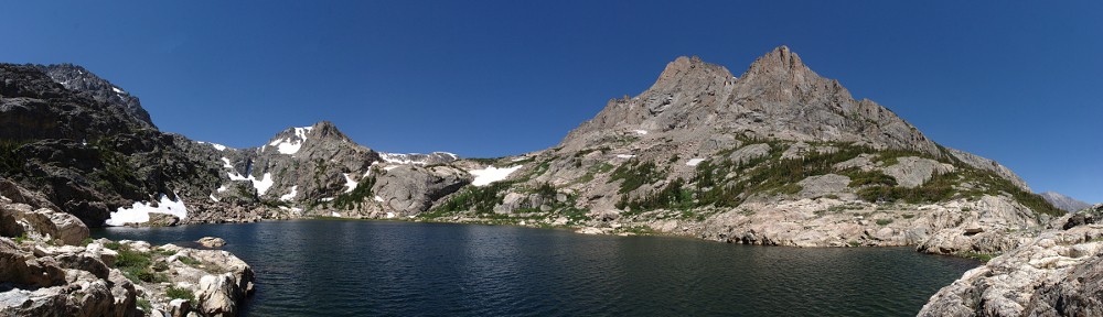
We weren’t making great time, what with finding the best route past rock outcrops or through dense pockets of trees. But it didn’t take too long to arrive at the larger of the Twin Lakes. This is the westernmost, larger one. These lakes are snow fed, neither has an inlet or outlet stream. They’re pretty shallow and, again, I’ve been to larger unnamed ponds in the park. But the view to the west from this lake was very nice. As expected, the wind was quite strong here. At times the wind gusts were so strong they kicked spray up ten or fifteen feet above the water.
 We found a place more or less out of the wind and I set up the SLR to do the time lapse. We sat and ate part of our lunches and watched the world go by for about a half hour. Upon retrieving the camera I saw that I neglected to use my usual settings. There are a number of things I have to change from my usual shooting – turn off auto-focus, turn off stability, set it on full manual and set the proper exposure, configure the timer. And change it from storing raw images with large, fine JPG to a smaller image. This is the first time I’ve managed to forget this part. So I filled the memory card pretty quickly. Oops. I’ve been meaning to buy a bigger card; perhaps this error will be the impetus for me to get it done.
 After getting our gear together, we headed the short distance to the other Twin Lake. It’s just a few yards away, and up a few feet of elevation. We passed through a little aspen grove. This one turned out to be perhaps the most interesting aspen grove I’ve walked through. Some beaver had been busy here, gnawing through dozens of trees. Some had been downed, chewed through completely. Others were still works in progress. The wood chips looked fairly fresh; I doubt this work was abandoned, but what do I know?
I didn’t see anything like a beaver lodge in either lake, and there are no streams here. The beaver must be in one of the lakes, though. These were pretty big trees; there was no other possible body of water this lumber could be taken to, unless that beaver has access to a helicopter or something. Which probably means I wouldn’t recognize a beaver lodge if I was standing on it.
 There is almost no view at the smaller of the two lakes, so we didn’t dally there long. From here, we headed almost straight up slope. We only needed to gain about two hundred feet to top the ridge. We passed a couple of cairns and came across what I think is a wildlife trail. After topping the ridge, a small unnamed pond was next, just below us. The pond sits, as is common, surrounded by marshy grass. Being nearly November, it was mostly dried out.
Sandbeach Creek feeds this pond. The map also shows a gully a bit to the west of the creek. We found ourselves ascending this gully rather than the creek. The gully is clearly a flowing stream during spring and summer; now it’s dry but verdant, filled with moss covered rocks, darkly green in the shade of the forest. In places, it looks like there is dried mud covering some of the rocks. It’s not mud, but a dried fibrous sheet a couple millimeters thick.
The gully opened into a clearing where we hopped up a pile of rocks about thirty feet high before returning to another mossy section. Here I decided we needed to head a bit more towards the east. “Just over this next rise we’ll find the lake.” It wasn’t the first time I said it, but I was finally correct. We emerged on the shore of Sandbeach Lake just a few yards to the west of the outlet stream.
It was calm here on the lee shore. It was also mostly devoid of an interesting view, so we circled counter clockwise toward the trail. The wind was quite intense on the east side of the lake. And because this used to be a reservoir like Lawn Lake, there aren’t any trees along the shore to provide shelter. We retreated into the forest, found a nice rock to sit on, and ate more of our lunches. I decided not to set up either camera as I figured neither would be able to sit still in this wind. So it goes. It’s unlikely I have enough footage to bother with a video this time.
There were a few other hikers there. We talked to two guys who spent the night there. They had heard there was an alternate route back to the trailhead. I got my map out and showed them a route I considered for this hike. And, as we no longer needed it, I gave them the map.
The hike out was uneventful. The wind seemed to be dying down a bit, and the skies remained clear overhead. Crossing Hunters Creek, I wondered if there was a bridge there that was washed away last September. There are just sawn logs there now. Perhaps I’m just misremembering. We arrived at my car a few minutes before three, still feeling fresh and in agreement that it was a fun hike. The off trail excursion was pleasant and the beaver activity at the lakes was unusual and quite interesting.
On a final note… I regularly wonder how often my car shows up on Instagram or Facebook. People are always taking pictures when I’m at stop lights or in parking lots. This evening, my son found my car on Facebook. It’s a picture taken today, at the trailhead. Too funny.