Sunday, September 20
Denver’s forecast for Sunday was mid-80’s and clear. It sounded like ideal weather for one last hike above treeline. The goal this time was Isolation Lake. I’d been leaving my options open; there are two lakes above Bluebird Lake that I’ve never been to. Junco Lake is about a mile, across terrain I’ve not gotten a good look at. Isolation Lake is at 12,000′, accessed via a bit over a mile of open tundra. I was undecided which I’d visit until I got to the Park.
I wanted to be on the trail about 7:30. I wasn’t sure how long it would take me to get to Bluebird. It’s 6.3 miles, with the last mile fairly steep. I figured the stretch between Bluebird and Isolation would take an hour, so I wanted to be to Bluebird by eleven. I was between Boulder and Lyons for sunrise. Not a cloud in the sky. The drive all the way to the Park was pleasant – there was almost no traffic.
At the trailhead I snagged an end spot. The lot was perhaps a third full. Somehow I got the idea that the bridge had been repaired at Ouzel Falls, but they had signs up saying it was still out. I could try that way on the hike out, as it would only cost me a mile or so if I had to turn around.
Above Copeland Falls they’re nearly done with significant repairs to the trail, damaged two years ago. With the bridge out, I had to take the campsite route to the Thunder Lake trail. I’d been calling it an unimproved trail, but the bridge out sign called it “primitive”. It’s your basic forest trail that gains about seven hundred feet of elevation.
The trail to Ouzel Lake follows the spine of a ridge that was burned in the Ouzel fire in 1978. It’s like a big eraser went through there, removing a strip mature forest a half mile wide and several miles long. This time of year you get a better sense of how much of this strip has been filled in by aspen, the only aspen visible south of the St. Vrain. This section of trail is exposed to the wind and sun. The sun was shining brightly in a clear, deep blue sky. On a July or August afternoon this would be a fierce sun but this morning was quite pleasant. It wasn’t calm, just a light breeze.
Before exiting the burn scar and returning to the forest we pass just above Chickadee Pond and Ouzel Lake to the south. The trail makes climbs a quick four hundred feet, flattens out to cross a talus field, then climbs another four hundred. In this second climb I chatted with a hiker on his way down. “Did you spend the night up here?” “No, thank God. The wind is bad, maybe sixty miles an hour.”
That was a bit discouraging. From Bluebird to Isolation is open tundra, so I’d be hiking into the teeth of the wind. I can assume I might find a big rock to use as a wind break when I got to Isolation, but don’t really know. While it is probably quite pleasant to sit at 12,000′ in bright sunshine and calm, with any sort of wind it will be cold.
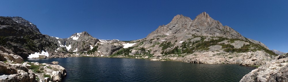
When I got to Bluebird I didn’t even take a picture. The wind was fierce. Maybe not sixty but easily forty miles an hour. I took one look in the general direction of my goal and turned around. Although the hike to Junco is more sheltered, the wind wouldn’t be any better. So Plan B is picnic at Ouzel.
 Rather than go back to the trail junction, I bushwhacked the hundred yards or so from the Bluebird Lake trail, going between Chickadee Pond and Ouzel Lake. It’s a forest lake, without an abundance of rocks. I tried to find a spot on a rock, in the sun, out of the wind, close to the water. Today, no such place existed. I did find a spot in the shade, slightly protected from the wind. I didn’t set up for a time lapse as there still wasn’t a cloud in the sky.
 Below Ouzel Lake I ran into a guy coming up. “Boy, am I glad to see you and this trail!” He didn’t see the bridge out sign at the trailhead and made his way to Ouzel Falls. He went upstream on game trails until he found a spot to cross, but went a long way before regaining the trail. There was no point in heading to Ouzel Falls now that the missing bridge was confirmed. Ouzel Falls is only a nice spot for a break if you’re on the other side of the river.
I took another break on a rock outcropping on the campsite cutoff. Even so, with the shortened hike and abbreviated picnic, I was back to the car by 2:30. Traffic was not nearly as bad as I expected. I assumed lots of people would be driving around viewing the aspen. There was some of that; lots of convertibles and even a couple of early sixties British sports cars. But not heavy traffic, and everybody managed to go as fast as the speed limit for the most part. That is, until reaching Boulder where a biker raced to get to the front of the line then proceeded to putt along at twenty under the limit.
The hike itself was quite pleasant. Once away from the lake, even on the exposed ridge, there was no wind to speak of. And I didn’t see a cloud in the sky the entire day. I didn’t bag a new lake today, but that’s okay. I can pencil another attempt at Isolation on the calendar for next August.

