Mike and I talked about hiking to Pipit Lake. It hadn’t really occurred to me to hike there in winter; I guess I’m still stuck in the “hiking is for summer” mindset. But after trading a few emails on Tuesday, we decided to go the next day. It would be the best weather for at least the next week.
I picked Mike up at the park and ride and we headed to the park. His bus was a few minutes late, and we were in the teeth of rush hour traffic into Boulder so we didn’t exactly get an early start. The Wild Basin entrance station is closed for winter – that is, there is no ranger there. That’s pretty much standard year around, if you arrive early enough. Up the road we go, only to find the gate closed before the road crosses the river. This was new to me. I really had no idea when that gate was ever closed. I thought perhaps it got closed when snow piled up on the road.
We geared up and started up the road. The thermometer read 44 degrees when we left the car at 9:00. On the drive up, the sky was mostly cloudy, with some rather ominous looking dark clouds to the west. At the trailhead, though, it was clear blue skies above us and to the west, with fairly strong winds. It took us twenty minutes to reach the trailhead; we figured we’d hiked a mile already.
We made good time on the first part of the trail to the campsite shortcut. We’d passed a few trees that had fallen across the trail, something I’d not seen here before. Approaching Calypso Cascades, there was a spot where water flows over the trail. There are several logs serving as steps; water had filled the spaces between the logs and frozen making terraces of ice – miniature skating rinks.
From Calypso Cascades to a bit past Ouzel Falls the trail is on a north facing slope and is now covered with ice or packed snow. There’s not much snow on the ground, just on the trail. I don’t know how this season compares to normal, I suspect it might be drier than usual, but it’s still early.
 We took a short break at Ouzel Falls. A great mass of ice has built up at the base and it looks like the ice at the left side forms each night and melts during the day. A large chunk fell off while we were sitting there.
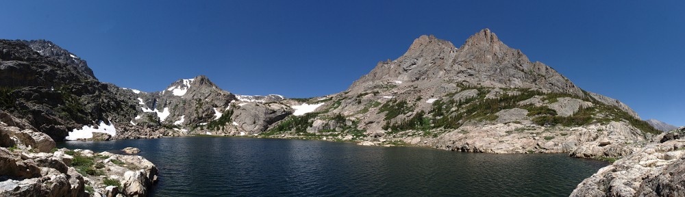
Continuing, we paused for a minute or two at the next trail junction, where the Thunder Lake trail goes right and Ouzel/Bluebird goes left. We would soon be atop the ridge which had burned back in 1978 and I anticipated it would be quite windy. Time to put on a hat to keep the ears warm. Gaining the top of the ridge, the wind was breathtaking at times. The occasional gust stopped me in my tracks. There is no shelter on this section of trail, which is not so good when it’s windy or in the summer sun. But it’s always good for the open views of the surrounding mountains.

At the lake I set up the GoPro for a time lapse. I didn’t bother with the SLR as there were very few clouds, just a few small ones above the nearby peaks that dissipated before they moved too far. Also, I found that the original battery for the SLR had died after taking only a handful of shots during the hike to the lake.
We looked for a place out of the wind to have our picnic lunches and ended up at the campsite. No view, but mostly out of the wind. After a short while, I went back to the shore of the lake and retrieved the camera. I had placed it on a rock only an inch or so above the ice. It was the best I could do, but not good enough. The wind had blown it over. I managed to salvage the footage. I didn’t do any fancy cropping to simulate pans or zooms; all the camera motion is caused by the wind. The first segment is at half normal speed (two seconds per minute) while the second segment is normal (one second per minute).
On the way out, we opted to continue a short way up the Thunder Lake trail to the upper junction of the campsite shortcut. It’s always nice to see a little different terrain. I think the shortcut saves six or seven tenths of a mile when hiking to Thunder Lake, but we had to go four tenths to get to it. So the hike out was a few tenths shorter than the hike in. We were also on the sunny side of the valley so we took another short break there.
By now I was figuring we were the only visitors to Wild Basin. I was surprised when we encountered three groups of hikers heading toward Calypso Cascades (two couples and a solo hiker). In retrospect, we probably would have met somebody at Ouzel Falls. We were the first ones to the end of the road in the morning, but when we returned to the car there were about a dozen other cars there. Not alone in Wild Basin, but only meeting five other people on that lower section of main trail is about as much solitude as can be expected.
Timetable
| Car | 09:00 AM |
| Trailhead | 09:20 AM |
| Campsite shortcut (bottom) | 09:50 AM |
| Calypso Cascades | 10:00 AM |
| Ouzel Falls | 10:30 AM |
| Thunder/Ouzel jct | 10:50 AM |
| Ouzel/Bluebird jct | 11:35 AM |
| Arrive Ouzel Lake | 11:50 AM |
| Depart Ouzel Lake | 12:35 PM |
| Ouzel/Bluebird jct | 12:50 PM |
| Thunder/Ouzel jct | 01:25 PM |
| Campsite shortcut (top) | 01:35 PM |
| Campsite shortcut (bottom) | 02:10 PM |
| Trailhead | 02:40 PM |
| Car | 03:00 PM |