Monday, September 14
I arrived at the Sandbeach Lake trailhead a few minutes after seven. The skies were without a cloud, and compared to the last several weeks, it looked like there wasn’t any smoke. Now that it’s mid-September, it’s starting to get a bit cool. It looked to be another glorious day in the Park.
I’ve decided that the timed entry passes aren’t being checked here in Wild Basin. As usual, there was nobody at the entrance station before eight. And when I returned from my hike at about 3:30, there was still nobody there. Perhaps the thinking is that there is fairly limited parking in this part of the Park and therefore it can’t get overcrowded.
Anyway, I put boots on the trail by a quarter after seven. My plan, I told myself, was to hike to Keplinger Lake. This is my third trip up Hunters Creek, first time falling short of Keplinger, second time succeeding. On my way down on my successful trip, I thought I had a pretty nice route. I figured it would be fairly trivial to retrace my steps and given my starting time I expected to arrive there by something like 11:30.
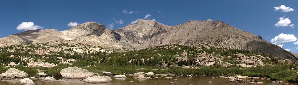
Keplinger is about seven miles from the trailhead. Half of that is on the trail to Sandbeach Lake. It alternates between fairly steep climbs (for a pack trail) and level stretches unencumbered by roots or rocks. I kept seeing small hoof prints. These were much smaller than those made by a horse, but looked almost the same: perfect horseshoe shapes, just a few inches across.

I haven’t heard of anybody who likes my route. I just follow Hunters Creek, using a trail I believe to be frequented by people climbing Longs Peak from this side. The trail is not maintained but is quite easy to follow except for two places where some deadfall has blocked it. After about a mile and a quarter, a stream joins Hunters Creek from the north, while Hunters Creek turns to the west. I cross this unnamed tributary here and continue up Hunters Creek.
The forest isn’t very dense through here, allowing sunlight to dapple the ground. The trick is to cross Hunters Creek before it makes a turn to the north. If you continue following the creek, you’ll end up in the messy mass of willow that surrounds an unnamed pond at about 11,200′. There was the terminus of my first attempt to reach Keplinger.
Today, I crossed Hunters Creek fairly early. I figured it didn’t really make much difference. All I needed to do was work my way through some trees and I’d find a treeless gully I could follow up the slope to where the creek drains from another unnamed pond, this one at about 11,400′. From there, it’s maybe a third of a mile to the lake.
Getting to the top of the gully puts you back on the banks of the creek between the two ponds. I stopped here for a short break. At least, that was my plan. It was a very pleasant spot. Due north of me was Pagoda Mountain. An arm of the mountain reaches to the south, toward me. Just to the left of this arm, directly below the summit, lies Keplinger Lake. I could have made it there in twenty minutes or so. To the right of Pagoda are Longs and Meeker. From this angle, Meeker looks to be the highest and biggest, and Longs looks … unclimbable.

I decided I didn’t need to go any farther. It had been cool enough all morning that I never took off my hoodie. It wouldn’t be any warmer at Keplinger, a couple hundred feet higher. The view of Pagoda is much more dramatic there, but the other peaks are hidden. Keplinger is all rocks and water; vegetation is sparse. Here, there was almost no breeze. Directly above me, the sky was almost its usual brilliant blue but there was a noticeable smoky haze on the horizon.
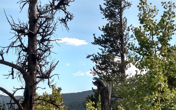
From the time I started hiking until I stopped here for lunch, I’d watched a number of helicopters fly overhead. At first, I thought there were two choppers sporting similar livery. The first two passes overhead were in the same direction: from roughly the direction of Allenspark and passing between Pagoda and Longs to go over Glacier Gorge. There may have been just the one helicopter and I missed its return trip. I didn’t know what they were up to. My first thought was that they were dealing with the Cameron Peak fire somehow, but they weren’t carrying a bucket or any other obvious cargo. They stopped flying over at about 11:00.

I let the world go by for half an hour, ate my sandwich, drank my beer, and relaxed.
If I had brought a map with me, I probably would have tried an alternate route back. That would be everybody’s preferred route, which goes by Sandbeach Lake. Looking east, I’d stay out of the trees then head over the forested hump at the eastern end of Mount Orton, then descend to the lake. I’ll come back here again and give that route a shot.
I did stay out of the trees for a longer distance than on my way up. It was easy walking and I made good time. I kept thinking I should make my way to the creek but kept delaying it. I found a game and followed it. It snowed that fell last week, several inches of wet, heavy stuff. Sometimes it was hard to tell if it had been walked through or if it was just knocked down by the snow. I saw several places where it looked like elk had bedded down, but hadn’t seen any elk, deer, or moose all day. I finally did spot an elk for an instant: she heard me coming and ran away. I saw a flash of her backside as she fled through the trees.

When I got to the end of this series of treeless gullies I found myself at the top of an outcropping I wasn’t willing to descend, so I had to backtrack a bit and find a route that didn’t bother me. I came across a talus field I spotted on the way up. It wasn’t the greatest route, but the rocks weren’t too big for me to make my way down.
Back in the woods I slowly worked my way to the creek. I came across a small pond I didn’t expect to find. It’s not on my map, but I did later find it on the satellite image. Back at the creek, I found an easy crossing and was back on ground I’d navigated before. I didn’t bother sticking too close to the creek. I can roam anywhere I want, as long as I head downhill. Eventually, I’ll run into the tributary I crossed when I left the climbers trail or I’d be back to Hunters Creek.
Staying away from the creek made for easier walking. The forest is sparse enough that there’s no deadfall to speak of and it’s late enough in the season that everything is dry. In July, I’d certainly be running into various trickles of water and marshy/grassy leas, and route finding would be more challenging. I shortly reached the tributary and crossed it to regain the climbers’ trail. I was only about fifty yards upstream of where I crossed on my way up.
I took a short break when I got back to the trail to Sandbeach Lake. I refilled my water bottle and ate the last of my fruit. I considered making the side trip to the lake, figuring it would take me an hour or a bit more. I was up for it physically, but I didn’t want to take more than an hour and figured it wasn’t worth making the trip if I couldn’t relax for a while at the lake. So I headed back to the car.
When I started hiking again, I heard another helicopter. I paid more attention to them now, noting the times they flew over and which direction they were going. They passed very close to the west side of Longs Peak. I’m sure anybody on the summit got a good look down on them.
The first flight of the afternoon was headed towards Glacier Gorge and it flew over me on its way back twenty minutes later. Twenty minutes after that, it was headed back to Glacier Gorge. This chopper made two round trips. Then a different one came from Glacier Gorge. It was a different model of aircraft, candy apple red instead of the orange and white of the earlier one. Instead of flying away, it descended into the valley below me. It took me a while to spot it through the trees. After a few minutes, it took off on its way back to Glacier Gorge. It made this trip twice.
I made it back to the trailhead by 3:30. I was curious to know what the helicopters were up to. I’d have asked the ranger at the entrance station, had there been a ranger there. There was a group of motorcyclists there, taking a break and using the restrooms. So I asked the bikers if they knew anything. They hadn’t been there very long, and the red chopper never flew over here, stopping a bit west of Copeland Lake. They didn’t know anything about the choppers.
I was a bit surprised when one of them asked me what was on my hat. I’m always wearing my hat from Autobahn Country Club. The guy who asked was thinking my hat was from a track in New Jersey. I gave him points for knowing it was a track and told him it was Autobahn, in Illinois. He said he’d driven that track. I didn’t quiz him, but he did mention running laps at a few California tracks, so maybe he’s been to as many tracks as I have. I neglected to ask him whether he tracked a bike or a car.
He did ask me what I drove. He expressed surprise that I could fit in an Elise. And he was pretty well acquainted with Lotus. He asked if I’d “added any lightness” to it. “As a matter of fact, I have!” We chatted about track days for a bit.
It was another beautiful day in the neighborhood. I hiked about thirteen miles, climbing about 3100′. The weather was ideal. I saw only one person from 7:15 to 3:30 and didn’t see him until after 2:30. I’ve never had such solitude before. It doesn’t get much better than that.
Searching the news when I got home, I see that teams were out searching for a missing hiker. His car was found at the Glacier Gorge parking lot and he was assumed to be attempting the Glacier Gorge Traverse. That’s a “difficult 19 mile route” that crosses eleven summits. It seems they found his body today (Tuesday). The article I read says that they flew his body to a landing zone in Wild Basin. I can’t help but wonder if the article has the timing a bit wrong. Were they taking him out on the last helicopter I saw? How unfortunate. He was my son’s age.
Sounds like another wonder day!