
Saturday I hiked to Box Lake and Eagle Lake.
I was hoping to hit the trail by 7:30, but I got out of the house a few minutes late and had to stop for gas in Lyons. I was late enough I had to show my pass at the entrance and the rangers were directing traffic in the parking lot. Again I was parked in a small end spot right next to the trash cans and bathrooms.
“You were here last week, weren’t you?” No, it was three weeks ago. “Yeah, you were parked at the Finch Lake trailhead.” Turns out he used to own an Elise. A red one – he said everybody asked if it was a Ferrari.
He asked where I was headed and told me the bridge at Ouzel Falls is out. It didn’t matter to me; I take the campground shortcut anyway. He then told me a sow with two cubs has been hanging around Thunder Lake.
I wasn’t much behind schedule; hit the trail at 7:45. To get to Box Lake you must first get to Thunder Lake. The distance is 6.2 miles with a climb of only a tad over two thousand feet. The first stretch of trail follows the North St. Vrain. This part is heavily traveled in the afternoon with folks out to see Calypso Cascades. You arrive at the campground shortcut just before the trail crosses the river. The shortcut meets the Thunder Lake trail above the second river crossing and eliminates Calypso Cascades, Ouzel Falls, and six tenths of a mile.
With the exception of the campground shortcut, the trail is generally wide, seldom steep, and often free of rocks and roots, allowing for a faster pace. The next milestone is the junction with the Lion Lake trail. This is about halfway from the shortcut to Thunder Lake. Next are a couple of stream crossings and finally a short descent to the lake. Rather than the usual hitch rack there’s a corral.
Once at Thunder Lake, the idea is to cross the outlet, contour around the eastern buttress of Tanima Peak and ascend a gully to Box Lake. Foster warns “be careful not to get too high on the steep, cliff-ridden slopes.” From Box Lake, climb to the top of the next bench to reach Eagle Lake.
The streams are running quite high for mid-August, and Thunder Lake was spilling into the meadow on its eastern shore in several places. The water flows through the grass in a great swath. It’s possible to cross without going more than ankle deep, but only just.
Once across the outlet, there’s a faint trail. I didn’t spot it at first so I headed around the slope. I quickly found the trail. Long stretches of it aren’t so faint, but it does fade in and out in the grassier parts. I think that without a trail, I doubt I’d have gotten there. For the most part, the trail took the obvious route. But there were times when I’d have gone a different way if there was no trail.
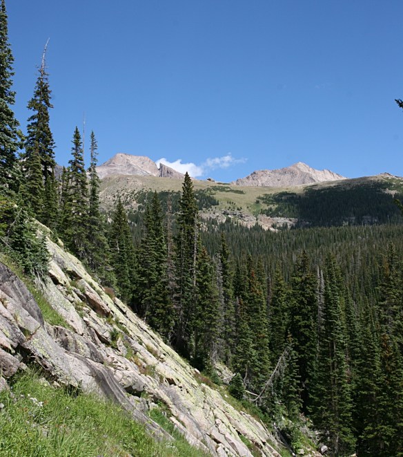
The route alternates between forest and meadow. The meadows are vibrantly carpeted with blue, yellow, red, and white wildflowers. It was quite breezy at Thunder Lake, but here in the lee of Tanima Peak it is calm. The sun is shining brightly in a brilliant blue sky punctuated with the small, fast moving clouds so common here along the divide.
The trail dips a bit before reaching the gully. Here we climb through meadows bordered by granite. Water burbles down the slope, feeding the prolific flowers. There is a rich insect life here, as well. The mosquitoes were out in force. Every time I stopped I was swarmed by them.

Box Lake sits just over the top of the gulley. While it’s in a nice setting, the surrounding views are not dramatic. Eagle Lake is the true destination on this hike, and it’s just another quarter mile away. Climb another gully to the top of the next bench. Foster warns about “nasty krummholz” but the path I took it wasn’t a problem. There’s an unnamed pond here, bigger than I was expecting. It has a nice view of the valleys to the east. Continuing on over mostly bare rock, it was a simple matter of following cairns in a straight line to my destination.

Eagle Lake is fairly large. I sat on a rock above the lake with views of the Continental Divide over the lake to the west and Mt. Meeker and a sliver of Longs to the South. I set up the cameras then broke out my picnic lunch. It never ceases to amaze me how much better food tastes when I’m sitting by an alpine lake.

As is usual in these places, it was a bit breezy. I was looking forward to a breeze thinking it would minimize the mosquito situation. Unfortunately, the damn things managed to buzz around my head the whole time I was there. I don’t think I got bitten, but they sure were annoying.
After about forty minutes I started packing up. The weather was still quite nice. With all the moisture we’ve been having lately I was concerned a thunder shower would brew up, but there was never a threatening cloud.
There wasn’t much traffic on the trail in the morning. Near the trailhead I passed a group of six or eight guys loaded down with gear. Three runners passed me about a half hour apart and I chatted with a solo hiker on the shortcut section. On the way down I ran into people as soon as I returned to Thunder Lake.
Just after I passed the spur to the campsite, I encountered another group of heavily laden hikers. They were going to do Mt. Alice tomorrow, via Lake of Many Winds and Boulder-Grand Pass. It wasn’t until a few after we chatted that I realized this was the same group I passed first thing in the morning. Made me feel sort of good. I made it to Thunder Lake in two and a half hours and it took these guys half my age six. Of course, they had heavy packs, were only going as fast as their slowest guy, and for all I know they took a side trip to Lion Lake.

Shortly after talking to them I met another solo hiker refilling his water from a stream. He had hit the trail at five and spent most of the day above treeline. From Lion Lake he summited Mt Alice, Pilot Mtn, and Tanima Peak. Quite an ambitious hike. He probably beat me back to the parking lot by a half hour.
Timetable
| There | Back | |
| Trailhead | 07:45 AM | 04:25 PM |
| Shortcut (bottom) | 08:10 AM | 03:50 PM |
| Shortcut (top) | 08:50 AM | 03:05 PM |
| Lion Lake trail jct | 09:20 AM | 02:30 PM |
| Thunder Lake | 10:15 AM | 01:25 PM |
| Box Lake | 11:15 PM | 12:30 PM |
| Eagle Lake | 11:35 PM | 12:20 PM |


