Cony Lake sits on a bench 11,512′ above sea level, surrounded by Mount Copeland, Ogalalla Peak, and Elk Tooth. It also sits on the southern boundary of RMNP. To get there, you must first get to Pear Lake, which is six or seven miles from the trailhead (depending on where you start). At Pear Lake, follow the trail by the hitchrack. This trail passes a small pond where it crosses the park boundary.
Lower and Middle Hutcheson Lakes are in Roosevelt National Forest. The faint trail leads to the lower lake before heading uphill on the northern bank of Cony Creek. The trail gets fainter and eventually disappears. Route finding from here to Upper Hutcheson can be difficult over terrain of rock benches, grassy ramps, and bands of dense willow and krummholz.
This is the fourth year in a row I’ve set off for Cony Lake. It doesn’t bother me to fall short when hiking in the Park. I’ve almost never had a bad day hiking. Each of the other times I tried Cony were memorable. The first time I had to stop at Pear Lake but got to watch clouds roll in just feet off the surface of the water. The second time I saw a bear sitting on the trail in front of me. Last year I watched an eagle catch a fish.
I started from the Allenspark trailhead rather than the Finch Lake trailhead. It saves a little distance and elevation. I wanted to drive the Chrysler because the parking lot is not Lotus friendly but it was in the shop. It was drive the Lotus or stay home, and I wasn’t about to stay home. There are two entrances to the parking lot at the trailhead. The first one features several large craters but the second is not so bad. I was able to get in and out without scraping.
The weather was ideal. Clear, cloudless sky, a brilliant blue all morning and only a slight breeze, even above treeline.
Over the last few days I’ve spent some time visualizing the hike, mainly the approach to Upper Hutcheson. I saw myself working my way uphill without getting into the willows. I could see the ramp you descend to cross the creek right below the lake. Last year I made it as far as the inlet to Upper Hutcheson and was stymied there. I had stayed along the shore and intended to ascend alongside the creek. It’s not a good route. This time I’d start climbing almost as soon as I got on the other side of the lake, traverse the slope to above the obstructions.
Just as I saw it in my mind, I made my way up without getting stuck in the willows. I crossed the stream right at the outlet of Upper Hutcheson. This is easy to do this time of year when the water level is down somewhat. It’s probably not a good route in July. There’s a nice grassy ramp right down to the water, a few stepping stones and you’re across. I made it the rest of the way without hitting any willow. Instead, it was a lot of rock hopping. Perhaps an excessive amount of rock hopping; I was certainly tired of it by the time I was done with it.
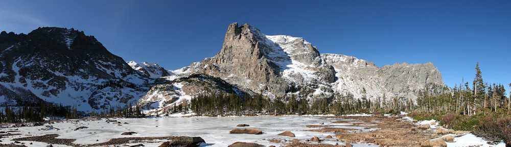
My approximate route (drawn on a 2015 photo)
I spent an hour at the lake. I was happy with my pace all the way up. I put boots on the trail at 7:30 and dropped my pack on a rock at the lake at 12:15. It took me fifteen minutes longer going back down, but that includes a stop to refill the water bottle. I didn’t get back to the car until after six, the latest finish I can recall.
The lake is bigger than I was expecting. I sat on a giant rectangular boulder the size of a bedroom, got the GoPro running and tucked into my lunch. There were no squirrels in this boulder field, and there were no birds. A few mosquitoes buzzed me and a few flies were somehow attracted to the camera. It was quite calm, which is unusual along the divide. Some clouds were attempting to cross but were never more than incipient. They got more energetic shortly after I left Cony, some white puffs drifted over Elk Tooth, diffusing the shadows and taking the edge of the bright sunshine.
Coming down from below Upper Hutcheson I ended up in a maze of krummholz and willow. I found myself in a few of the same spots I was in last year, or the year before. I went one way, back tracked, tried another. And another, and another. Eventually I dove through a particularly nasty clump of krummholz and from then on was in the clear, but I’m disappointed I wasn’t able to retrace my steps.
I’m wearing my hiking shoes, not the boots. On the way up I hit my right ankle on a rock, tore a flap of skin. This was situated right above the shoe and when I little toe was uphill of my big toe, that flap rubbed on the shoe. About half my steps when rock hopping had my foot situated that way. By the time I was back on the trail my ankle had gone from irritating to annoyingly painful.
I was surprised at how few people I encountered. On the way up, I exchanged hellos with a group of three and a group of five. I had a brief chat with a fellow from Luxembourg. He hiked Mt. Idea a couple weeks ago, then camped in the Grand Tetons. Then it was the Badlands and a stop in Nebraska before returning to RMNP. His plan today was to lunch in Estes, then drive to the Great Sand Dunes. A pretty cool trip. I met him just below Pear a few minutes before ten.
I didn’t see another person until I was nearly back to Finch, almost six and a half hours later. I’m usually the one asking people where they’re headed, or where they’ve been. Today, though, I was the one being surveyed. After passing Finch Lake, I saw only six people. One young guy coming the other way asked “Finch or Pear?” I told him “Cony.” He hadn’t even slowed down to ask the question, but my answer stopped him in his tracks. “Way to go, buddy!” It was deja vu just after the big trail junction. A guy passing me asked “Finch or Pear?” “Cony.” “Wow”.
It’s been my habit to say something along the lines of “I felt great when I got back to the car.” That would be a fib today. I was pretty fatigued and the ankle didn’t help. It’s not the longest hike I’ve done, or the biggest climb. But I’d say it’s one of the most difficult. It’s a long hike to Pear, then miles of no trail and challenging route finding.
Cony Lake sits lies at the upper end of the Cony Creek drainage, south of Mount Copeland at the southern edge of the Park. Starting at the Finch Lake trailhead, it’s a 9.2 mile hike climbing over 3,000 feet. If you start at the Allenspark trailhead instead, you save a mile each way and five hundred feet of elevation.
Two years ago I made it as far as Pear Lake. I took a break there to eat some fruit. After the break I hiked up the bench to the south where I came across a pond. Here I realized I’d abandoned the camera at Pear Lake, so I had to turn around. It was just as well – clouds rolled in from the east, just feet above the lake. Last year I got as far as Upper Hutcheson Lake. I struggled through a mass of willow only to see snow covered slopes on the other side of the lake. Between my lack of spikes in mid-July and losing time in the willow, it was an easy decision to stop there.
Third time’s a charm, right? Saving eleven percent of the distance and fifteen percent of the climb will make it easier. I’m going nearly a month later in the season this time, and I have a better idea of the lay of the land. I felt good about my prospects.
We’ve been having hot, clear weather lately but Saturday’s weather forecast degraded every day all week. It would be cool with a good chance for rain. I hit the road at 5:30, planning to be on the trail by 7:00. Low clouds obscured all the peaks. Meeker, Longs, and Pagoda were mostly clear, but everything to the south was in a layer of clouds with a ceiling not far above treeline. Above that, blue skies to the west and a layer of high clouds to the east.
This was my first visit to the Allenspark trailhead. I couldn’t see the parking lot on the satellite images, so I wasn’t sure if I’d be able to park. It’s a bit over a mile up a dirt road and if I couldn’t park there I’d have to use the Finch Lake trailhead. There’s room for a dozen cars in the trees, but the entrance has a giant rut. I pondered for a second and gave it a try. It was sketchy, but I made it in without scraping bottom.
I was on schedule: on the trail promptly at seven. Another solo hiker arrived in the parking lot after me; he passed me on the trail before I’d done a mile. I asked him where he was headed. He said “Pear for sure, maybe a bit farther.” I told him I was headed to Cony. He said perhaps we’d see each other again, but he was moving at a much quicker pace than I was managing.
From the trailhead to the Finch Lake trail junction just below the Ouzel burn scar is 1.8 miles. It’s been nearly forty years since the fire. It’s no longer an area of dead sentinels and wildflowers. The new trees are getting bigger, but it’s not forest yet so the spectacular view is relatively unobscured.
There were very few other hikers. In the six miles to Pear Lake, I ran into eight or ten folks hiking out and a few more who were still at the Pear Creek campsite. I did catch up to the other hiker, Jason, between Finch and Pear. He put the afterburners on after his break and he was quickly out of sight.
A cacophony of wildflowers
Foster says, at Pear Lake “follow the unimproved but recognizable trail”. The first time I tried Cony, I went on the other side of the lake. The second, I followed the trail along the shore until it faded out, then headed up. I was thinking this was the unimproved but recognizable trail. I found out on the way back that I wasn’t even close. Anyway, I’d been here before so it was no trouble to find Lower Hutcheson Lake.
According to Foster’s map, the route is to cross Cony Creek just above the lower lake, then recross at the outlet of the middle lake. The crossing at the lower lake was easy – the stream has split into two narrower channels. Up slope a ways I found myself blocked by krummholz and willow. After squeezing through one gap I noticed my water bottle was missing. It must have fallen out right here.
But no. A thorough search yielded nothing. Clearly, I lost it earlier. I made my way back down, not exactly sure how I’d come up. I think I was backtracking correctly, but did I go on this side of this clump of bushes, or that side? Shortly before I was back to where I crossed the second portion of the creek I saw Jason on the opposite hillside. I hollered at him to hold up.
I made my way over to him, told him I’d lost my water. I’d have to turn back with no water. He kindly gave me a liter of water. He was going to keep going for a while so I got out my map for us to consult. I have it marked with Foster’s route. I told him I’d look for my water bottle a little while longer before giving up. I found it almost immediately, sitting on the bank of the creek.
Following Foster’s route we found ourselves back where was when I realized I’d lost my water. It didn’t take long for us to decide to switch back to the north side of the creek. A couple minutes after crossing we found a nice trail. This dumped us on to a series of rock slabs. We were able to follow a few cairns, but that was it. From here, it’s a good idea to climb upslope a bit to avoid the krummholz and willow. Above the middle lake, Jason called it quits. He’d told his wive he’d be back at a specific time, and this was all the farther he could go.
I had no fun in the willow along the north shore of Upper Hutcheson last year, so I decided I’d stay higher up on the slope and avoid it. Foster’s route was on the south shore, but her route below was wrong and I no longer trusted it. So off I went, climbing slowly but steadily up the slope of Mount Copeland as I worked my way west. It didn’t take long to realize I still had quite a way to climb to avoid the krummholz. I paused to assessed the situation.
The north shore is a longer route than the south shore, as I’d need to go south to get to Cony. There was much less willow on the south; it looked like I could go right along the water and avoid it. If I went straight downslope where I was, it was a pretty easy route. The willow weren’t too thick there.
On the south shore, at this time of year with the water low, it looked like I could hop across the rocks right at the waters edge and avoid the bushes. It almost worked – I made it quite a distance but right at the end the rocks were too far apart, and the water had gone from a few inches deep to well over boot height. So, another short backtrack.
I finally find myself at the south western end of Upper Hutcheson Lake, just a few tenths of a mile away, at the top of a four hundred feet climb. I find myself at the base of a vast sea of willow. I either have to backtrack to go over the outcropping on my left or wade through the willow. It’s 11:30. I clearly won’t make Cony by noon. The sky is blue to the west, but some of the clouds to the east might drop some rain. I decide to abort the assault on Cony Lake and have my picnic here.
I haven’t replaced the tripod yet, but I did remember to bring the shutter timer this time. I found a nice rock to use as a base and set the camera. I faced a bit of a dilemma. To the west, small clouds were coming over the divide then boiling away but the foreground not interesting. To the east the clouds were higher and slower moving and the lake is in the foreground, Too bad I only had the one camera.
It was cool and windy. I was in sunlight for the most part but had little shelter from the wind. I sat in the lee of a small boulder and ate while the camera clicked away. After a short while I realized I didn’t hear the camera shutter. Was I too far, was the wind blowing the sound away from me? No, the camera had stopped with “Err 99”. I’ve had this happen occasionally. Just turn it off and back on and it’s cleared. It ran only for a few more minutes before getting the error again.
After restarting it the second time, I started to have second thoughts as to what I should be shooting. I let it run a while longer before switching it to the west. Then, of course, those clouds seemed to be going away. Have I made a mistake? Ah, well. You never know what you’re going to get.
Taking an hour break gives you a lot of time to take in the surroundings. It was windy and the nearby willows not so much rustled as hissed, at times almost loud enough to drown out the sound of falling water. I wasn’t hearing the inlet in the willows but a waterfall on the canyon wall two hundred feet up. There was quite a bit of water coming down but the talus twenty feet below the bottom of the falls was dry. From the looks of it, it’s always dry, even in max flow.
The windbreaker was beginning to feel inadequate after an hour of lounging. It was time to pack up and get moving again. My next navigational problem was getting back to the other side of the creek. I wanted to avoid the willow as much as possible. Perhaps Foster’s route here on the south side was correct after all. Being above the landscape gives a much different perspective on things than being in the landscape, looking up.
There’s a small pond below the upper lake. With water levels so low, it’s easy to skirt the southern shore to a nice crossing to a grassy slope on the other side. Easy, peasy.
It was here that I started to reflect on the day so far. I lost my water bottle and had to backtrack to retrieve it. I made a few navigational errors and I didn’t achieve my objective. Instead, I sat at the edge of a beautiful alpine lake for an hour and watched the world go by. Okay, the camera futzed out a couple of times. But all in all, there’s nothing to complain about. It’s just another beautiful day in the neighborhood.
Above Pear Lake I managed to stumble upon the trail Foster mentions. It’s quite well defined here and going is easy. I soon see Pear Lake below me – I’m well above the shore. And yet the trail refuses to descend. How can this trail not go down to the lake? I cut cross-country. About halfway from the trail to the shore I come across a nice outcropping of rocks with a view and decide it’s time to take a break.
It’s peach season. Lots of people think of Georgia when they think of peaches, but I think the best peaches are grown on the western slope of Colorado. I have one of these Palisades peaches with me. This particular example is top rate: perfectly ripe and perfectly juicy; sweet and full of flavor. I always say food tastes better at alpine lakes, but this peach would be one of the finest peaches ever, even in my kitchen.
So I’m luxuriating in this wonderful peach, enjoying the now clear and brilliant blue skies above. What could be better than this? As I’m eating the peach, I spot an eagle soaring over the lake, fishing. She circled a few times then dove. The water erupted in a big splash and momentarily she arose, the silver of a fish clearly evident in her claws. Then she made a couple of wide circles above the lake, as if to show off her kill, before heading to the trees on the other side.
Bear left for Hutcheson
Break over, I got back on the move. There’s a hitching post where the trail arrives at the lake. It’s here that you get the trail to Hutcheson Lakes. This is the trail I was just on. I walked right by it at least twice without figuring it out.
My next stop was the stream crossing at the Pear Creek campsite. I needed to replenish the water supply. Not ten steps on the other side of the creek I stumbled over a rock on the trail. I do this countless times each hike; it’s never a big deal, I never lose my balance. This time I “went over the handlebars” as Michael might say. My left foot slipped, I went down on my left knee and put my hands out to stop my fall. My left hand slipped as well and I ended up on my elbow. This resulted in an ugly abrasion on my left forearm.
It stung, and it was bloody. At least the stream was right there. I had it washed off in no time and used one of my paper towels to stanch the flow. I basically lost the skin along the bony part of the forearm – five or six inches long and a quarter inch wide. I took a couple of ibuprofen and was back under locomotion ten minutes later.
Most of the day I’d been shrugging off all the minor mishaps – I was having a great time in spite of losing my water bottle, the camera acting flaky, minor navigational issues. I’m in a beautiful place and it’s hard not to enjoy it. But the gods wanted to test my limits and had that rock grab my toe.
Chief’s Head and Pagoda. From left to right, see the chief’s forehead, nose, and chin. Pagoda would be his pointy bra.
I was back to the car by 5:20. Turns out there are two entrances to the parking lot; the southern one lacks obstacles and I was out without any additional drama. Even though it was nice and sunny, it wasn’t hot so I headed down the road topless. Traffic wasn’t bad and it was a pleasant drive home.
About a week ago I decided it was time to hike to Cony Lake. Last time I tried to hike to Cony I took a break at Pear Lake where I managed to leave my the SLR and tripod. Although the mission was aborted, I enjoyed a long lunch at Pear.
It’s 9.2 miles to Cony. I’d forgotten how long it was until I checked the Foster guide for a refresher. I wasn’t sure I was ready for an eighteen and a half mile hike. I spent a couple days telling myself I could do it. By Friday morning, there was no wavering. All systems go for a 6am departure, boots on the trail by 7:30. Last year it took me three hours to get to Pear. It’s 2.2 miles from Pear to Cony, so that shouldn’t be more than an hour and a half. Two hours tops. Lunch at Cony by 12:30, half hour lunch, back to the car by 6pm.
Saturday dawned cool and cloudless but a bit hazy – smoke from the fires in Washington and Oregon? I hit the road a few minutes behind schedule but traffic was light and I put boots on the trail promptly at 7:30. I brought micro spikes with me, but at the last moment decided not to carry them.
The trail climbs steeply from the parking lot to the top of the first ridge, about six hundred feet in a bit over a half mile. The climb ends with a hairpin; turning west the trail borders a meadow then enters an aspen grove. At the junction with Allenspark trail, another long climb begins – six hundred more feet in a half mile. Shortly after the junction we enter the eastern end of the burn area from 1978. Nice views of Meeker, Longs, Pagoda, and Chiefs Head can still be had, but the trees are getting big enough the view will not be do open for long. From this vantage point, it’s clear how Chiefs Head got its name.
From here the trail flattens out again before a short descent to Finch Lake. We are five miles and 1400 vertical feet from the car in a shade under two hours. Finch Lake isn’t much to my taste – what it lacks in a nice view it makes up for with an abundance of mosquitoes. To now I’d only encountered a few hikers. Here I met a large family. They spent the night here and asked me about the trail to Pear.
From Finch to Pear is two miles and seven hundred vertical feet. Two short steep parts with an interlude in between. The east buttress of Mt. Copeland rises from the forest on the right as we pass a small pond on the left.
Pear Lake was a reservoir for most of the 20th century. There’s still a visible bathtub ring, but the vegetation is slowly overcoming that. Even another thirty years won’t erase all evidence; a large boulder on the northwest shore will be two toned for some time to come. I made it in three hours almost on the dot.
Last year I went around Pear lake to the right. I followed Foster’s route and took the vague trail on the left side. This petered out pretty quickly and by the time I started climbing I was on my own. A short distance away were some folks getting situated on a large rock overlooking Pear Lake. By now I’d seen only about a dozen people.
A small stream feeds Pear here, not a large amount of water, but in several small courses braided up the hillside. I went up the east side, far enough away to avoid the marshy spots. There are a couple of unnamed ponds showing on the map here, and perhaps a couple more that aren’t on the map. After passing one of these I came to the top of the ridge and saw Middle Hutcheson Lake below me.
I headed down the hill a bit to Cony Creek. According to the map in Foster’s guide, I should cross to the south side of the creek about here. It runs in two or three major channels and I could cross it fairly easily. But after having a good look around I decide to stay on the north side. After climbing a hundred feet or so, I saw another hiker on an outcropping below me, on the south side. I don’t know that he saw me; it didn’t look like he was climbing any further.
I didn’t want to deal with the krummholz and willow, so I tended to be higher on the slope. Just below Upper Hutcheson Lake I saw an older couple headed the other way. The were a bit upslope of me and said that was the better route. A few minutes later I arrived at the ponds immediately below Upper Hutcheson and saw another couple. They had been to Cony before and thought it was too early in the season to continue to Cony. There was too much snow. I followed them through a couple patches of willow and to the shore of the lake.
It was 12:15. From here, I’d have to cross the talus slopes above Upper Hutcheson to the inlet, then up two hundred feet to the ledge that hold Cony. I quickly decided to stop here and put Cony on the to-do list for some August or September. Even had I brought the spikes, I was still at least a half hour from Cony. Next time I try this, I think I can save at least fifteen minutes between Pear and Upper Hutcheson having now scouted the route.
I set up the cameras and ate my lunch. The clouds building over the divide were darkening and at 12:40 it started to sprinkle. I packed up and started down. The couple were fishing and decided to wait out the squall. It took me an hour and a half to hike up from Pear but only an hour down. I considered stopping here for a fruit break. The few sprinkles had stopped pretty quickly, but now it was starting up again with bigger raindrops.
By the Pear Creek campsite the sun was shinning again. Here I met a back country ranger. We chatted for five or ten minutes. I learned that much of the park is designated wilderness. I thought it was just a park, but everything a mile from any trail is wilderness. I refilled the water bottle from the creek and headed to Finch. To my chagrin, my knees started getting a bit sore on the steeper downhill sections.
I polished off half my remaining fruit but didn’t dally long. The mosquitoes made a snack of me. I carry some mosquito repellant wipes in the pack, but the seal had broken and they were dried out. Oh well.
On the uphill section immediately after Finch Lake, I came across a couple who had spent the night at Pear Creek. As it was mid afternoon by now, I asked what they did all morning. They had hiked to Cony Lake. Somehow I didn’t see them, but they must have passed me while I was eating lunch. They described their route and said it wasn’t difficult even with the snow.
After this point, my progress slowed considerably. Every downhill stretch gave me a fair amount of pain in the knees. This sometimes happens, but not often. In my ignorance, I will blame it on taking such a long hike without getting in proper hiking shape. I don’t normally tackle the longer hikes until I’ve done a few intermediate length ones first.
By the last mile, fatigue had set in as well. Too tired to properly pick my feet up, I was now stumbling over roots and rocks. This added to the discomfort. The first couple times I rested, my knees felt better for a while, but for the last couple of miles rest did not aid. I made it to the car promptly at six; were it not for the pain I would have finished 30 or 45 minutes earlier. So it goes.

 Coming down from below Upper Hutcheson I ended up in a maze of krummholz and willow. I found myself in a few of the same spots I was in last year, or the year before. I went one way, back tracked, tried another. And another, and another. Eventually I dove through a particularly nasty clump of krummholz and from then on was in the clear, but I’m disappointed I wasn’t able to retrace my steps.


