Crystal Lake Redux

Last year, Gordon and I spent two nights camping at Lost Lake with the intention of hiking up to Rowe Glacier. I stopped at Scotch Lake but Gordon continued. For a short while, he thought he’d made it to the glacier but finally decided that he, too, had fallen short. When I opened discussion of our next backpacking trip he casually said that he was thinking of visiting Rowe Glacier as a day hike.

I have little doubt that he is capable of doing in one day what I failed to do in three, but I wasn’t sure he was serious. I told him there’s a shorter route, one that would get him to the summit of Hagues Peak as well. I told him, “I happen to have a timed entry pass for 9/5. We could hike together to Lawn Lake, then you could blaze ahead while I hang around at Crystal or Lawn. I could theoretically do the saddle instead of Crystal, but I wouldn’t want to slow you down.”

And, so, we more or less had a plan.

Saturday, September 5

On my trip to Crystal Lake back in July, I arrived at the trailhead a few minutes before seven. That was a weekday and the lot was nearly full. Assuming that on a weekend there might be more people on the trail, we agreed we’d need to start at about the same time. So Gordon arrived at my place to pick me up a few minutes before five-thirty. He brought Eric, one of his co-workers, to join us.

Both Eric and Gordon are fitter than I am, but for the hike to Lawn Lake, they let me set the pace. In July, it took me 2:45 to get from the trailhead to Lawn Lake. Today, I was just a slight bit faster: 2:39. I’ll admit that that made me a bit proud. It’s not exactly a metronomic pace, but it is nice and consistent.

I didn’t stop, or even pause, really, until a bit past Lawn Lake. I wanted to use my first break to apply some SPF and I figured a nice place to do that was sitting on a rock with a view of Lawn Lake below me. I did pause, very briefly, a few minutes earlier to try to get a picture of a bull moose that was a few yards off the trail. He was shy. I got a picture of his backside, but he kept foliage between his head and me. Perhaps he was thinking I couldn’t see him if he couldn’t see me. A further few yards up the trail, we came across a group of deer: a doe and three spotted yearlings.

My break finished, I insisted both Gordon and Eric go ahead of me. It’s steeper here, and where I stopped was about 11,200′ in elevation. The air is getting noticeably thin. There’s no way I can keep up my earlier pace, and I don’t even try.

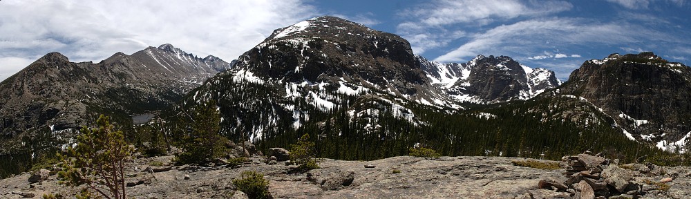
This is my third time up here, and the first two times I always followed the spur trail to Crystal Lake. This time I continued up toward The Saddle. Not long after this junction, the trail crosses a stream. This is not the outlet from Crystal Lake. Although there’s almost no snow left in the area, the stream still has a significant flow. I couldn’t help but wonder where all the water was coming from. It’s just an indication of how much water the grassy/marshy landscape holds.

Eric was well ahead of Gordon, and Gordon was just thirty or forty yards ahead of me. He pointed out a herd of sheep browsing along the stream. We weren’t very close, and the only camera I had was the cell phone. And the phone isn’t particularly good for telephoto shots. But at least the subjects didn’t go to great pains to hide their heads from me. I wasn’t entirely sure, but I figured they were bighorn sheep, even though I didn’t see any rams with horns that curved all the way around. I’m now thinking they were some combination of ewes and yearlings. I’m pretty sure this is the first time in my adult life that I’ve spotted bighorn sheep in the Park.

Bighorn sheep

Several minutes later, I caught up with Eric. He had tweaked his knee last Sunday hiking Mt. Evans. He was feeling pretty good when we started, but by now he figured if he kept going he might be in a bit more pain than he was willing to put up with. So he decided not to go any further. We weren’t that far from The Saddle. I was hoping to make it that far, just to look over the other side, but I decided it wasn’t that important. I told him there’s a nice spot a bit below us where we could sit on a rock and look down on Crystal Lake. It seemed like an ideal place for a picnic.

Eric takes in the view: Lawn Lake, Little Crystal Lake, Crystal Lake, and Fairchild Mountain

I didn’t pay particular attention to how long we sat on that rock. It was at least half an hour. We had a good view of the lakes below and the spur trail, but I didn’t see anybody down there. On my first visit to Crystal Lake, many years ago, I was the only one there. But two months ago the place was crowded, and that was a weekday. So I was a bit surprised nobody was there today.

Eric started back to the car. He wanted to take his time and didn’t want to slow us down. After a few minutes I decided to make a quick visit to Crystal Lake. It looked to me like it should be easy to cross the little isthmus between the two lakes to find a spot on the north shore of the lake to get a slightly different view.

I didn’t go all the way back to the trail junction, but struck off cross-country, saving me maybe three-tenths of a mile. It all looked so simple from above, but on the ground it was a bit more complicated. Then again, I didn’t spend a lot of time looking for a route. I was guessing Gordon was making quick time of things, and I didn’t want him to pass me on the way out. So my exploration was cursory, and I’ll save a more thorough attempt for my next visit.

I was getting low on water but didn’t replenish my supply at Lawn Lake. I was thinking that I’d have a chance to refill at one of the switchbacks, where I’d be close to Roaring River. This was poor thinking. The river isn’t convenient to the trail until a few yards above the junction to Ypsilon Lake. I made it that far (now not much more than thirty minutes from the trailhead) and stopped. I rummaged through my pack but couldn’t find my Steri-Pen. I would have sworn I had it. I just replaced the batteries in it. But perhaps I neglected to return it to the pack.

A bit below the Ypsilon turnoff, I ran into a couple headed up. They asked if I’d made it to any of the lakes. We chatted a bit. It was nearly four now. I told them it took me nearly three hours to get to Lawn Lake, that Ypsilon was a bit closer, but perhaps a bit steeper. While we were chatting, a group of four hikers passed us in great haste, heading down.

“See that cloud? It’s not a cloud. There’s a fire just over the ridge!” That wasn’t a very good description. I asked them where they were hiking from. They said they’d been to Ypsilon. In any event, I wasn’t certain what I was seeing was smoke instead of clouds, and what did they mean by “just over the ridge”? They didn’t stick around to provide any more details.

Continuing our discussion, I suggested to the couple that they go as far as the river crossing on the Ypsilon trail. They were unlikely to make any lake and get back out before dark. Then they asked for suggestions for tomorrow. Hopefully, they’ll be happy with my guidance.

I made it back to the trailhead at 4:18. I asked Eric how long he’d been waiting; he said he wasn’t waiting long and that he’d gotten a nice little nap. During our chat, I related the tale of my missing Steri-Pen, which I now easily found in the pack. How could I have missed it?

Gordon arrived about an hour later. By now, there was no doubt that what was above us was smoke and not cloud.

When I was applying my sunscreen above Lawn Lake, we all noted how clear the skies were. There wasn’t a cloud in the sky, and the smoke we’d been seeing (and smelling) for much of the last month was gone. While waiting for Gordon, Eric and I talked about how folks in the backcountry would never know about a new fire: they’d only know what they saw. We wondered what Gordon may have seen.

He showed us a couple of pictures he took from the summit of Hagues Peak. From his description of the direction and distance, I guessed that this was the Cameron Peak fire, which I haven’t heard about in several days.

Well, it’s in the news again. The smoke plume over our heads was, indeed, from the Cameron Peak fire. This plume went up 36,000′ and as I write this the fire has expanded to more than 34,000 acres (an increase of 10,000 acres Saturday alone) and is dumping ash on Greeley. It has now crossed into the Park and several trails and roads have been closed.

Smoke from the Cameron Peak fire

Every hike I take, I have some goal in mind. Today, it was to reach The Saddle and look over the other side. I didn’t make it. Falling short of my hiking goals just serves as an excuse for another attempt at a later date. Still on the table here are The Saddle and a bit of exploration of the isthmus between Little Crystal Lake and Crystal Lake. And, just a mile up the Black Canyon trail is a body of water called Potts Puddle. So there are still a few new sights for me in this area.

Crystal Lake

Up to now, I’ve been buying my timed entry passes well in advance. They released the vast majority of passes back in June for June and July. They also release a tranche of passes two days in advance. That is if you didn’t buy a pass in advance for, say, July 1, and you decide you want to go, they make an additional number available on 6/29 at 8 am MT. If you look at a date that has sold out, it’ll show how many they’ll release 2 days in advance. For the 6-8 am slot, it looks like 65 passes each day.

Wanting to hike on Wednesday, I signed on Monday morning to get a pass. I refreshed my page promptly at 8 and made my purchase. By the time I selected the date, time, and type of pass, it said only 40 of the 65 were still available. After completing the process, I went back to see how many were left. At 8:03, it was down to 7.

Clearly, the best way to get a pass is to buy one when the bulk of them are released. And, as it turns out, passes for August become available on July 1. Of course, I’ll be on the trail when August passes become available but I’m thinking that they won’t get snapped up much faster than they were in June. When I made my first reservations, there were hundreds available for each day/time I wanted.

Having obtained my pass, the next issue was where to hike. I’ve done a pretty thorough job of visiting lakes that are readily accessible. What’s left will either require camping or are at elevations or in locations where there’s likely still too much snow on the ground. And I’d like to avoid the crowded trails in the Bear Lake area. With this in mind, I decided on Crystal Lake, which I last visited back in 2011. It’s high enough that snow might be a problem, but the higher sections of trail are on south facing slopes.

Wednesday, July 1

I was thinking I wanted to be on the trail at about 7:30. I thought the lake is seven and a half miles up the trail, but I see that the Foster guide says it’s 7.9, with 2,960′ of elevation gain. I figured I could maintain a two mile per hour pace up to Lawn Lake, then somewhat slower for the bit above eleven thousand feet.

I left the house at 5:30 and, encountering little traffic, I was at the trailhead a few minutes before seven. There were plenty of empty parking spaces, and a couple of hikers started on their way while I was getting ready. I hit the trail spot on 7:00. Before leaving the car, I sprayed on some mosquito repellent. I don’t normally carry it with me for a day hike and hoped that a single application would do the trick.

The first section of trail gets your heart going right away, climbing about 700′ in a little over a mile. That’s about double the average rate of climb for the entire hike. The trail to Lawn Lake is a pack trail, so it’s mostly free of roots and rocks and never gets too steep.

The first navigation point is the junction with the Ypsilon Lake trail. I didn’t catch up to the hikers who left the parking lot before me, but I did encounter a group of four hiking back to the trailhead. If they were camping, they left their campsite quite early, and I can’t imagine how any day trippers were already on their way out.

The next section of trail, a bit over four miles, more or less follows Roaring River. When the river is in view, it’s quite dramatic. The Lawn Lake dam failed back in 1982, releasing something like 30 million cubic feet of water at a peak rate of 18,000 cubic feet per second. The effects are almost as visible today as they were nearly 40 years ago. The careful observer will note places where the trail was washed away. That really doesn’t explain it properly: it wasn’t so much that the trail was washed away, but that the hillside the trail passed over was washed away.

There are places where a hundred feet of hillside looks to have been scoured away. Trees on the edge of these cliffs are dead but still standing, half their roots supported only by air. Continuing erosion is obvious. Not just earth being washed away from above by rain and snow, but the stream still undercutting the banks. In wider spots, the deluge deposited large piles of tree trunks. In narrower places, everything was washed away, leaving bare bedrock. In some places, the flood scar is visible from miles away. The pace of life is slower at altitude; even in forty years, new trees and shrubs have barely started growing back.

Mummy Mountain and flood-scarred Roaring River

For the most part, this section of trail is easy walking. Fairly long stretches of nearly level trail are broken by short, steeper climbs that feature a few switchbacks. As the trail more or less follows the stream, it’s at the bottom of the forest valley, so there are no views to speak of. I also will note that my mosquito preparation was (today, anyway) unnecessary: I neither heard nor saw a single mosquito.

Not long before reaching Lawn Lake, there’s a junction with the Black Canyon Trail. You could theoretically get to the Cow Creek trailhead or Gem Lake or Twin Owls from here, but I’m not sure why anybody would want to. I haven’t hiked it, but I imagine it’s mile after mile of vista-free walking. But it exists, and appears to be both well-maintained and well-traveled. So somebody must find it useful.

Lawn Lake is the end of the pack trail. There are two hitching posts here, one for llamas, one for horses. From here to Crystal Lake, the trail is narrower and steeper. At times it goes right through small patches of willow where it resembles a game trail and will get you a wet boot if you’re not watching your step.

Just above Lawn Lake the trail rises above treeline and leaves the forest behind. I stopped here with the idea that I’d slather on some SPF. But the sun’s warmth was a bit feeble and the breeze was definitely not feeble so instead of sunscreen, I put on my jacket. Much of my hike so far had been in shade. It was well after nine before a single ray of sunlight hit my body. I was expecting things to warm up as the day progressed, but clearly that wasn’t in the cards this morning. I did put sunscreen on my face and hands, though, as the sun above 11,000′, while pleasant, is harsh.

To this point, I hadn’t seen any hikers (other than the group of four right at the start). There was a guy fishing at Lawn Lake and a hiker there sitting on a rock. While I was getting my jacket on, she passed me on her way to Crystal Lake.

Lawn Lake, with Longs Peak in the distance

There really wasn’t much snow along the way. In some shady spots around Lawn Lake there were a few drifts not much bigger than a few paces across. A bit more than half way up the slope there’s another trail junction, with a spur trail that takes you to The Saddle. I considered heading up this way, not to the top of the saddle, but far enough up to get a view of Crystal Lake from above. It was still fairly early, so I had plenty of time, but my pace had slowed considerably and the cool, stiff breeze was a deterrent. I continued to the lake.

Mummy Mountain towers over Lawn Lake

Not far after the junction I came to the only stretch of snow worth mentioning. Standing on the eastern edge and looking west, I couldn’t see the trail. Lucky for me, the gal who passed me had already crossed the snow and was working her way along the far edge. Scanning the terrain above her, I finally spotted the trail and so I made a direct line for it. I didn’t quite catch up to her, but I essentially wiped out the lead she had on me.

There are two lakes here, nearly side-by-side and differing by only three feet of elevation. The first one is Little Crystal Lake. It’s very scenic. Almost exactly as scenic, in fact, as its larger neighbor. But it is very much the “red-headed stepchild”; nobody seems to stop here to take in the view.

Little Crystal Lake and Fairchild Mountain

I caught up to the other hiker as we climbed onto the boulders that make up the shore of the lake. There we found a guy who was making an attempt at fishing. We sat on a rock about ten feet apart and chatted while we ate our lunches.

When I was last here, I had the place to myself. Today, at first it was three of us. I stayed about an hour and a half. While there, a group of four hikers arrived, then a solo hiker, then two more. On my way past Little Crystal Lake, another solo hiker arrived. Clearly, this place is more popular than I thought. Usually, if I’m going to a lake more than seven miles away there aren’t many (or any) other visitors.

Crystal Lake

Ironically, on the way up, from the Ypsilon trail junction to Lawn Lake I didn’t see anyone on the trails. And, likewise, on the way out it was the same thing. Usually, at any lake I visit where there are a dozen or so people, I’ll meet people on the trail who are headed to the same place, or have been there and are on their way back.

I didn’t see any big game, but the marmot population at Lawn Lake, Crystal Lake, and in between was impressive. They weren’t too shy, either. One perched himself on a pedestal-like rock and looked at me as if to say, “I’m ready for my portrait now!” Another made it’s home in a hole right next to the trail, only backing down out of sight when I got within a few feet.

Timetable

UpDown
Trailhead7:00 am4:08 pm
Ypsilon jct7:35 am3:33 pm
Black Canyon jct9:27 am1:50 pm
Lawn Lake9:45 am1:35 pm
Crystal Lake11:00 am12:30 pm