Up to now, I’ve been buying my timed entry passes well in advance. They released the vast majority of passes back in June for June and July. They also release a tranche of passes two days in advance. That is if you didn’t buy a pass in advance for, say, July 1, and you decide you want to go, they make an additional number available on 6/29 at 8 am MT. If you look at a date that has sold out, it’ll show how many they’ll release 2 days in advance. For the 6-8 am slot, it looks like 65 passes each day.
Wanting to hike on Wednesday, I signed on Monday morning to get a pass. I refreshed my page promptly at 8 and made my purchase. By the time I selected the date, time, and type of pass, it said only 40 of the 65 were still available. After completing the process, I went back to see how many were left. At 8:03, it was down to 7.
Clearly, the best way to get a pass is to buy one when the bulk of them are released. And, as it turns out, passes for August become available on July 1. Of course, I’ll be on the trail when August passes become available but I’m thinking that they won’t get snapped up much faster than they were in June. When I made my first reservations, there were hundreds available for each day/time I wanted.
Having obtained my pass, the next issue was where to hike. I’ve done a pretty thorough job of visiting lakes that are readily accessible. What’s left will either require camping or are at elevations or in locations where there’s likely still too much snow on the ground. And I’d like to avoid the crowded trails in the Bear Lake area. With this in mind, I decided on Crystal Lake, which I last visited back in 2011. It’s high enough that snow might be a problem, but the higher sections of trail are on south facing slopes.
Wednesday, July 1
I was thinking I wanted to be on the trail at about 7:30. I thought the lake is seven and a half miles up the trail, but I see that the Foster guide says it’s 7.9, with 2,960′ of elevation gain. I figured I could maintain a two mile per hour pace up to Lawn Lake, then somewhat slower for the bit above eleven thousand feet.
I left the house at 5:30 and, encountering little traffic, I was at the trailhead a few minutes before seven. There were plenty of empty parking spaces, and a couple of hikers started on their way while I was getting ready. I hit the trail spot on 7:00. Before leaving the car, I sprayed on some mosquito repellent. I don’t normally carry it with me for a day hike and hoped that a single application would do the trick.
The first section of trail gets your heart going right away, climbing about 700′ in a little over a mile. That’s about double the average rate of climb for the entire hike. The trail to Lawn Lake is a pack trail, so it’s mostly free of roots and rocks and never gets too steep.
The first navigation point is the junction with the Ypsilon Lake trail. I didn’t catch up to the hikers who left the parking lot before me, but I did encounter a group of four hiking back to the trailhead. If they were camping, they left their campsite quite early, and I can’t imagine how any day trippers were already on their way out.
The next section of trail, a bit over four miles, more or less follows Roaring River. When the river is in view, it’s quite dramatic. The Lawn Lake dam failed back in 1982, releasing something like 30 million cubic feet of water at a peak rate of 18,000 cubic feet per second. The effects are almost as visible today as they were nearly 40 years ago. The careful observer will note places where the trail was washed away. That really doesn’t explain it properly: it wasn’t so much that the trail was washed away, but that the hillside the trail passed over was washed away.
There are places where a hundred feet of hillside looks to have been scoured away. Trees on the edge of these cliffs are dead but still standing, half their roots supported only by air. Continuing erosion is obvious. Not just earth being washed away from above by rain and snow, but the stream still undercutting the banks. In wider spots, the deluge deposited large piles of tree trunks. In narrower places, everything was washed away, leaving bare bedrock. In some places, the flood scar is visible from miles away. The pace of life is slower at altitude; even in forty years, new trees and shrubs have barely started growing back.

For the most part, this section of trail is easy walking. Fairly long stretches of nearly level trail are broken by short, steeper climbs that feature a few switchbacks. As the trail more or less follows the stream, it’s at the bottom of the forest valley, so there are no views to speak of. I also will note that my mosquito preparation was (today, anyway) unnecessary: I neither heard nor saw a single mosquito.
Not long before reaching Lawn Lake, there’s a junction with the Black Canyon Trail. You could theoretically get to the Cow Creek trailhead or Gem Lake or Twin Owls from here, but I’m not sure why anybody would want to. I haven’t hiked it, but I imagine it’s mile after mile of vista-free walking. But it exists, and appears to be both well-maintained and well-traveled. So somebody must find it useful.
Lawn Lake is the end of the pack trail. There are two hitching posts here, one for llamas, one for horses. From here to Crystal Lake, the trail is narrower and steeper. At times it goes right through small patches of willow where it resembles a game trail and will get you a wet boot if you’re not watching your step.
Just above Lawn Lake the trail rises above treeline and leaves the forest behind. I stopped here with the idea that I’d slather on some SPF. But the sun’s warmth was a bit feeble and the breeze was definitely not feeble so instead of sunscreen, I put on my jacket. Much of my hike so far had been in shade. It was well after nine before a single ray of sunlight hit my body. I was expecting things to warm up as the day progressed, but clearly that wasn’t in the cards this morning. I did put sunscreen on my face and hands, though, as the sun above 11,000′, while pleasant, is harsh.
To this point, I hadn’t seen any hikers (other than the group of four right at the start). There was a guy fishing at Lawn Lake and a hiker there sitting on a rock. While I was getting my jacket on, she passed me on her way to Crystal Lake.

There really wasn’t much snow along the way. In some shady spots around Lawn Lake there were a few drifts not much bigger than a few paces across. A bit more than half way up the slope there’s another trail junction, with a spur trail that takes you to The Saddle. I considered heading up this way, not to the top of the saddle, but far enough up to get a view of Crystal Lake from above. It was still fairly early, so I had plenty of time, but my pace had slowed considerably and the cool, stiff breeze was a deterrent. I continued to the lake.

Not far after the junction I came to the only stretch of snow worth mentioning. Standing on the eastern edge and looking west, I couldn’t see the trail. Lucky for me, the gal who passed me had already crossed the snow and was working her way along the far edge. Scanning the terrain above her, I finally spotted the trail and so I made a direct line for it. I didn’t quite catch up to her, but I essentially wiped out the lead she had on me.
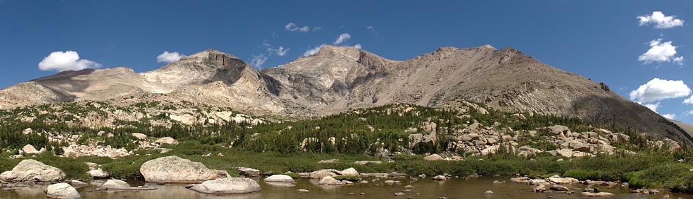
There are two lakes here, nearly side-by-side and differing by only three feet of elevation. The first one is Little Crystal Lake. It’s very scenic. Almost exactly as scenic, in fact, as its larger neighbor. But it is very much the “red-headed stepchild”; nobody seems to stop here to take in the view.

I caught up to the other hiker as we climbed onto the boulders that make up the shore of the lake. There we found a guy who was making an attempt at fishing. We sat on a rock about ten feet apart and chatted while we ate our lunches.
When I was last here, I had the place to myself. Today, at first it was three of us. I stayed about an hour and a half. While there, a group of four hikers arrived, then a solo hiker, then two more. On my way past Little Crystal Lake, another solo hiker arrived. Clearly, this place is more popular than I thought. Usually, if I’m going to a lake more than seven miles away there aren’t many (or any) other visitors.

Ironically, on the way up, from the Ypsilon trail junction to Lawn Lake I didn’t see anyone on the trails. And, likewise, on the way out it was the same thing. Usually, at any lake I visit where there are a dozen or so people, I’ll meet people on the trail who are headed to the same place, or have been there and are on their way back.

I didn’t see any big game, but the marmot population at Lawn Lake, Crystal Lake, and in between was impressive. They weren’t too shy, either. One perched himself on a pedestal-like rock and looked at me as if to say, “I’m ready for my portrait now!” Another made it’s home in a hole right next to the trail, only backing down out of sight when I got within a few feet.
Timetable
| Up | Down | |
| Trailhead | 7:00 am | 4:08 pm |
| Ypsilon jct | 7:35 am | 3:33 pm |
| Black Canyon jct | 9:27 am | 1:50 pm |
| Lawn Lake | 9:45 am | 1:35 pm |
| Crystal Lake | 11:00 am | 12:30 pm |