Sunday, September 8
Until now, whenever I fell short of a hiking goal the destination would get placed on next year’s list of hikes. After making a premature turn on my last hike I decided I didn’t really want to wait the better part of a year to make another stab at it. So off I headed to the south eastern corner of the Fall River Pass quadrangle, on the Mount Ida trail towards Gorge Lakes.
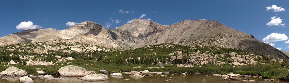
Again Trail Ridge Road was traffic-free and fun to drive. I stopped at Rock Cut for a quick look at my destination then headed to the trailhead. I’ve taken photos here several times and was never happy with the result. This time I got a fairly good shot, and include it here. The red line is more or less the route I took, visiting first ‘Amore Lake’, then Love Lake, and finally Arrowhead Lake.

Poudre Lake was shrouded in mist and a small cadre of photographers was there snapping away. I put boots on the trail twenty minutes earlier than last time and before long passed the point of my errant turn. When the trail got near the edge overlooking what I’ll now refer to as ‘Misplaced Valley’, I wandered over for a closer look.
Not far from there I left the trail and cut across the next ridge to a point where I’d get my first real look on the gorge.

A more intrepid hiker than myself might descend here. I’m not a big fan of steep descents, so I continue along the ridge line. My next landmark is cleverly named Point 11819. That is, it’s an unnamed point at 11,819′ above sea level. From here, that’s about a 600′ descent. At this point I considered abandoning the ridgeline and descending straight to Love Lake. It’s not too steep for me, but I figured I didn’t want to miss visiting ‘Amore Lake’ so I continued with the original plan.
Before leaving my vantage point, however, I should have used the telephoto lens to scope out the terrain surrounding the lakes below. Perhaps I’d have seen something to aid in my progress later. I guess I was just too wowed by the scenery to do anything like planning ahead.
Continuing down the ridgeline, I came to a ramp that led to ‘Amore Lake’. This is a pretty little officially unnamed pond. I skirted around the west side of it and went up and over the slight ridge separating it from Love Lake. I quickly found myself in difficult terrain. Trees on a steep rocky slope. I made my way easily enough through these and right into a patch of willow. I started flashing back to my hike to Keplinger Lake. But no worries, I was soon through this patch and descending another ramp to Love Lake.

From here, it looks like Love Lake and Arrowhead Lake are only a few yards apart. It’s more like a couple tenths of a mile and a hundred and fifty feet or so of elevation. Here’s where a bit of forethought would have come in handy. I continued along the west side of the lake, then up and over the slight rise. In retrospect, I think it would have been better to go on the east side of the lake and descend through the trees there. Why? Because I found myself in another giant patch of willow.
Before long, I gave up. You might say I technically didn’t reach Arrowhead Lake because I didn’t get close enough to put my toes in it. I’m going to count it anyway. I perched myself on a rock with a nice view of the lake and the surrounding mountains, set up the camera, and enjoyed my lunch. While relaxing, I surveyed the area in search of a way out that didn’t take me through the willow again. I thought I spied a wildlife trail and when I packed up to go, I headed that way.
This route was an illusion. Short of heading straight up the ridge there was no easy way out. So I forged through this patch of willow without too many new scratches on my legs. A few minutes after muscling my way through I was back on the shores of Love Lake where I refilled my water bottle.
Here I heard voices. I hadn’t seen anybody since early morning when I passed a couple on their way up Mount Ida. I met them at about treeline, more than five hours earlier. Scanning the slope above the lake I saw the first hiker coming through the willow in about the same place I went. He was talking to a companion, suggesting a route. After several minutes I saw four hikers total. Only the fourth found the route I intended to take out, missing the willow entirely.
I chatted with these guys for a few minutes. It was about 1:30 now. They asked if I went along the ridge above us and when I confirmed, they mentioned they’d seen me. This must have been nearly two hours earlier, as I’d spent an hour at Arrowhead. They came via Forest Canyon Pass. If I ever return here, I’ll give that route a shot for reasons that will become clear soon enough. I asked if they were spending the night, but they said that wasn’t in their plans. I wonder how long it took them to return to their car.

As we separated, it began to rain. It didn’t look to last too long so I didn’t bother with the poncho yet. The next mile or so from here would be grueling, gaining about a thousand feet. I considered cutting across ‘Misplaced Valley’ and returning to the trail using the same route I explored three weeks ago. The idea was, I’d need to gain about 400′ less elevation. But when I saw where I was, I decided to stay on my route in. To cut across here, I’d have to go down a few hundred feet so there’d be no real savings.

So I continued my climb. A few minutes later it started raining again. I had to often pause to take in the scenery. And to take in oxygen. I stopped and faced nearly due east. The wind was at my back, rain coming down at enough of an angle to keep my front dry. Judging by the clouds above me and the prevailing winds, I figured the rain would stop shortly. I continued my slog up the ridge.

Subtly, the wind shifted. I was under the edge of the rain cloud, but it was now moving south to north. I’d be right under this edge for a while unless the wind shifted back. The rain turned to hail for a short while and I donned the poncho. Looking to the north, things were getting ugly. I saw lightning strike on the other side of Trail Ridge Road. In the grand scheme of things, this is not very far – three or four miles as the ptarmigan flies.
This was not a happy development. I reckoned I was still two and a half hours away from the trailhead, and nearly the entire way is above treeline. I intended to stay well below the top of the ridge in order to gain as little elevation as necessary. This now seemed like a doubly good idea considering the weather. I couldn’t really increase my pace as I was climbing steadily. And I had to cross the occasional pile of rocks, which were now slippery with rain.
I took fairly regular breathers. I’d pick a point ahead, tell myself not to pause again until I reached it, pause for a few seconds and repeat. During one of these many pauses, I heard elk bugling below me in ‘Misplaced Valley’. ‘Tis the season! I wasn’t seeing any lightning ahead of me, but my vision was somewhat limited by the hood of the poncho. Thunder did occasionally boom, reassuringly distant. During my pauses I’d scan the slopes north of TRR – that’s where all the excitement was.
On the way up the Mount Ida trail, both this time and three weeks ago, I was thinking I’d have preferred the trail to be closer to the top of the ridge. Now, though, I was somewhat chagrined that it wasn’t a bit lower. When I regained the trail, I still wasn’t seeing any lightning but the thunder was noticeably more numerous but thankfully still some distance away.
I now increased my pace. The rain was coming down fairly steadily, and my poncho had developed a tear. If I let go of it, the poncho would slip backwards and the tear would get bigger, so I had to keep a hand on it. The pleasant morning walk and the hour lazing in the sun at Arrowhead now seemed like distant memories. I was no longer having any fun.
By the time I reached treeline, the peals of thunder were almost continuous and the lightning strikes were around me in all directions. Thankfully, none appeared to be within a mile, but still too close for comfort. I was happy now to be in the trees. Again I heard the bugle of an elk, much closer now than when I was atop the ridge. Normally, elk are seen and not heard. Today it was the opposite.
When I finally reached the car, it was raining quite heavily. To add to the fun, I had just had the car detailed. It was as clean as it had ever been since I bought it. When getting off the trail, I’ve always been able to sit in the open car door and change from boots to driving shoes but not today – muddy boots in the nice clean car. Oh, well.
It rained nearly all the way to Lyons. Between the three hours or so of rain while hiking and another hour and a half on the drive it was a pretty good downpour. But that was only a hint of what was to come. As I write this, both Estes Park and Lyons are cut off from the world; roads covered by debris or washed away. Nearly a whole year’s rain has fallen in the last couple days. I’ve seen video of downtown Estes Park and the water is perhaps as high as it was when the Lawn Lake damn burst back in 1982.
Timetable
| Up | Down | |
| Trailhead (10,758′) | 07:40 AM | 04:50 PM |
| Milner Pass trail jct | 07:55 AM | 04:35 PM |
| Unknown trail jct | 08:25 AM | 04:10 PM |
| Overlook @ 12,440′ | 10:25 AM | |
| Arrowhead Lake (11,120′) | 11:30 AM | 12:30 PM |