Gorge Lakes – Day 3

Sunday, August 5

Rain started again at about a quarter to six. We had breakfast in the rain, taking shelter under the trees. The sky was a uniform gray, giving no indication that the rain would break any time soon. We had a short discussion as to how long we were willing to wait before packing up in the rain. We came to no conclusion but fortunately before long the rain stopped and the sun poked through the clouds. We were packed up by shortly after eight.

The route back to the trailhead was up the high ridge. We’d turn north at Love Lake, climb up to the unnamed lake above it (‘Lake Amore’ in the Foster guide) and refill our water. From there, circle to the west then south to head up the ridge. Somewhere between 12,400’ and 12,600’ we’d gain the Mt. Ida trail and be home free.

When we got to where I said we should find Lake Amore we instead found just a puddle of water. The guys were confident that their filtration systems would handle this, so we filled up as this would be our last opportunity. I still had nearly a liter of good lake water but filled my other bottle anyway. In the end this was unnecessary and proved to be dead weight as I drank none of it. But better to carry water you don’t need than need water you didn’t carry.

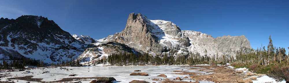
Love Lake (near) and Arrowhead Lake

I suspect we were on a rise slightly above and south of Lake Amore as my phone told me we were about forty feet higher than the map indicated for the lake. But I didn’t waste the steps to verify my suspicion. Once we filled up, Brad asked me if there was any reason we couldn’t just climb straight up the steep slope above us to gain the top of the ridge. It looked to be about two hundred fifty feet and quite steep. I’d have rather gone my route: longer but not so steep. I was outvoted, so up we went.

Yours truly, atop the ridge

We took our time working up the ridge and back to the trail. At altitude none of us was moving very swiftly and we took a number of short breaks. The wind was blowing fairly stiffly and the clouds to the west were building up threateningly. At one of our pauses, James asked “Did you hear that?” I didn’t hear anything until there was a break in the wind. It wasn’t the bugling of elk, but the yipping of coyotes. Not the howl I used to hear regularly during the night when I lived in Estes, but a definite yipping. I don’t think I’ve ever heard coyotes except at night.

View to the northwest. We crossed this valley (toward the right of the picture) Friday.

When we got to the trail we could see a rain squall to the south. Tim said he thought we’d miss it. We may have missed that one, but almost immediately after his remark we found ourselves getting rained on again. Back on the trail, and heading mostly downhill, our progress was a bit faster. Which was good, because we soon saw the flash of lightning. We had about three miles to cover before we gained treeline. For a short while, we got hailed on. The wind was stiff and blew the hail nearly horizontally.

The rain ended before we got back to treeline and we made it back to the car by 1:00pm without getting hit by lightning. On the drive back over Trail Ridge Road we stopped at the Rock Cut to review our trip. The general consensus (joking, I think) was that it was good we couldn’t see anything on Friday morning: “We’re going where?”

In the picture below, taken from Trail Ridge Road a bit west of the Rock Cut, we could see most of the terrain we crossed. The Mount Ida trail is on the other side of the ridge that climbs from right to left ending in about the center of the shot. We went off trail starting to the right of the snow field moving east (right to left) a bit below treeline. Gorge Lakes lie in the left third of the shot, under the pointy peak (Mount Julian).

View from Trail Ridge Road.

Conclusion

From the maps, it looked to me like I could reach all those lakes given enough time. I could have started my assault on the lakes an hour or more earlier than I did. And the weather worked against me. But it’s the terrain that stopped me, not bad weather or a lack of time. I just don’t have the skills or temperament to reach all these lakes. I certainly can’t get them on a day hike, and there are enough other remote places in the park that I’d like to visit that I’m unlikely to do another backpacking trip here.

I was quite happy with the borrowed backpack. It is borrowed no more: Paul has kindly given it to me. Thanks, Paul.

On the clothing front, I’ll have to look at getting some rain pants. I’m pretty sure my boots would have kept my feet dry had I not had water running down my legs. For around camp, I had my sweat pants and hoodie. I was comfortable with these, and used the hoodie as a pillow, but they’re on the bulky side and space in the pack is at a premium. So I’ll start investigating on that front. And I learned that I need to have enough socks.

I was pretty happy with my food selection, with the exception of the jerky bars. They left an odd aftertaste and the texture wasn’t at all like jerky. They were not what I was expecting. Next time I’ll go with your basic jerky.

All in all I enjoyed the trip. I won’t lie: I am disappointed that I only managed to get to one of the four lakes I was after, and that one only marginally. And the weather was, shall we say, less than ideal. I was tempted several times to say that I was cold, wet, and miserable. But I don’t think I’ve ever spent time in the park that I felt truly miserable. It’s an incredible place, and I’m happy to be there to experience it in all its variety.

Gorge Lakes – Day 2

Saturday, August 4

We broke camp by 8:15 and headed east around the buttress of the ridge in search of our next campsite. We needed to be a mile away from last night’s location, and I wanted to be as close as possible to where we’d be spending most of the day. We also needed to be in reasonable proximity to a water source.

When I got up this morning, I had the choice of wearing yesterday’s wet socks or the one pair of dry socks I carried. As my boots were still thoroughly wet, I went with the wet socks. I figured if I used the dry ones, they’d be wet pretty quickly and then all my socks would be wet. I wanted to keep a pair dry for the night. It made for cold feet for the start of the day but once we got going it wasn’t so bad.

In our passage through the forest we came upon the occasional bone. Yesterday I found a scapula, deer or elk I’m not sure which. Today we saw two more. I’m not sure why I see so many scapulae. I see more of them than anything else, with vertebrae next most common. I rarely see skulls. But we found an elk skull today.

Elk skull.

We bushwhacked more or less due east and came upon a small unnamed lake that lies at 11,000’. We needed to go a bit farther. The map shows a sort of plateau between 11,000’ and 11,200’ about two tenths of a mile ENE of Love Lake. I’m not sure that this area is within our zone, but I figured it was close, and it met all the other requirements of a legal campsite. We dropped our packs here and Brad and I went off in search of Love Lake.

Our navigation was spot-on and we arrived there after about fifteen minutes hiking. It sure was easier without our packs, but we should have at least carried a filter and a couple of empty bottles. So, other than the simple fact that we verified where we were, it was a wasted trip.

We headed back to our packs and selected our campsite on this plateau. I think it was a better spot than last night. The vegetation wasn’t as thick and we had some nice rocks to sit on. A couple of the rocks were in sunshine and would be handy for putting our wet items on in an attempt to dry them.

Once we set up camp, we decided on our day’s action plan. The guys all wanted to fish. The park’s website said there were fish in Rock Lake and the outlet from Arrowhead. I wanted to bag the four lakes I missed last time. So we went as a group up to Love Lake and from there down to the outlet of Arrowhead. I left them there and headed across the large rock outcroppings along the eastern side of Arrowhead toward Doughnut Lake.

Tim takes in the view

From the map, it looked like I could go from Doughnut up a gully to the southwest, over a ridge and then descend to Inkwell. From there, I should be able to follow the inlet stream up to Azure Lake. If things were still going well and I had enough time, I could follow that inlet stream to Highest Lake. From the slope above the northern end of Arrowhead, very little of this was visible. The terrain looked rugged, but passable.

So off I went to Doughnut. The ridge I traversed had a couple of large gullies leading up to saddles and so had three distinct summits. I made it to the first saddle easily enough. And from there to the second. The saddle between the second and third summits is shown on the map with two contour lines, or on the order of sixty to eighty feet. What I was faced with was a thirty foot cliff. I worked around the east side, but it’s quite steep here, too, essentially a fifty or sixty foot cliff. I was stymied.

I took a few pictures but never made it to the shore of the lake. I’m going to add it to my list, though. I’m saying I made it there, or close enough. I went west through the saddle looking for a way to get to the top of the next little summit, but no dice. So I found a place to sit down, eat my lunch, and run the GoPro for a while for a time lapse video.

Doughnut Lake

When we were up at Love Lake, we heard voices but didn’t see anybody. Now, down below me at the far southern end of Arrowhead I saw the other hikers. At first I only saw two, but there were four. They made their way to the base of a nice waterfall – the stream that flowed from Inkwell. It looked like they had found quite a nice place and they were there the whole time I was sitting there. They were a noisy bunch. They were about three hundred yards away and a hundred fifty feet below me. Once I thought perhaps they had spotted me and were yelling at me. I waved my arms but couldn’t see them responding.

I ran the camera for about thirty five minutes and watched the clouds roll by. I had a nice view of Trail Ridge in the distance. Had it been calm, I probably would have been able to hear the louder motorcycles and trucks. But it was quite windy. I tried to keep an eye out for incoming weather, but the high ridge to my west obscured my view. Before long, dark threatening clouds came over the gorge. I packed up the camera and started heading back to camp.

When I got to the top of the gully I took to get to the first saddle it started to rain. I popped into a small grove of trees just as it began to hail. I pondered how long I was willing to wait there. This squall could be over in a few minutes, or it could rain for hours. When the hail stopped the rain increased. Visibility across the lake was noticeably reduced. I waited a bit longer and the hail returned. After hail abated the second time, I set out again.

Arrowhead Lake panorama, above the eastern shore

Much of the way back to Love Lake was across open rock. The rock has quite a bit of lichen on it, and when that stuff is wet it can be quite slippery. I more or less was able to retrace my steps but did end up going through a nasty bit of krummholz that I didn’t encounter on the way up. Going through that, I got my pants soaked, which led to my damp socks getting pretty wet again.

Forest Canyon rain squall. Rock Lake visible 700′ below.

I made it back to the outlet of Arrowhead, crossed the stream without incident, and climbed the talus slope up to Love Lake. I went pretty slow, taking great care on the slippery rocks. Up on the shore of Love Lake I let my guard down and nearly slipped on rocks there.

On our way out for the day, we refilled water bottles at Love Lake. Everybody took what water they needed for the afternoon and we left some full bottles and our filter gear there. When I got there, everything was gone, so the guys had already returned to camp. If they quit fishing when the rain started, they had about an hours head start on me.

By the time I returned to camp, the rain had stopped and shortly thereafter the sun was shining brightly. I took the opportunity to take off my boots and socks and lay them out on a rock. Sadly, the sunshine didn’t last long and nothing quite got dry.

The guys told me they didn’t venture far from Arrowhead’s outlet. The park’s website said fish could be caught there, and down below in Rock Lake. The terrain is pretty rugged at there the outlet, and Rock Lake is something like 700’ below. They didn’t catch anything, but all had hits on their lines.

The evening was uneventful. The rain didn’t return before we turned in. Even so, it was an early night with everybody retiring before dark. I slept about as well as the night before; one excursion before midnight and otherwise sleeping in fits and spurts. It rained for about an hour starting at three. No dreams tonight, at least that I recall.

Arrowhead Lake

Sunday, September 8

Until now, whenever I fell short of a hiking goal the destination would get placed on next year’s list of hikes. After making a premature turn on my last hike I decided I didn’t really want to wait the better part of a year to make another stab at it. So off I headed to the south eastern corner of the Fall River Pass quadrangle, on the Mount Ida trail towards Gorge Lakes.

Again Trail Ridge Road was traffic-free and fun to drive. I stopped at Rock Cut for a quick look at my destination then headed to the trailhead. I’ve taken photos here several times and was never happy with the result. This time I got a fairly good shot, and include it here. The red line is more or less the route I took, visiting first ‘Amore Lake’, then Love Lake, and finally Arrowhead Lake.

My route, more or less

Poudre Lake was shrouded in mist and a small cadre of photographers was there snapping away. I put boots on the trail twenty minutes earlier than last time and before long passed the point of my errant turn. When the trail got near the edge overlooking what I’ll now refer to as ‘Misplaced Valley’, I wandered over for a closer look.

Not far from there I left the trail and cut across the next ridge to a point where I’d get my first real look on the gorge.

Seven lakes are visible in this photo

A more intrepid hiker than myself might descend here. I’m not a big fan of steep descents, so I continue along the ridge line. My next landmark is cleverly named Point 11819. That is, it’s an unnamed point at 11,819′ above sea level. From here, that’s about a 600′ descent. At this point I considered abandoning the ridgeline and descending straight to Love Lake. It’s not too steep for me, but I figured I didn’t want to miss visiting ‘Amore Lake’ so I continued with the original plan.

Before leaving my vantage point, however, I should have used the telephoto lens to scope out the terrain surrounding the lakes below. Perhaps I’d have seen something to aid in my progress later. I guess I was just too wowed by the scenery to do anything like planning ahead.

Continuing down the ridgeline, I came to a ramp that led to ‘Amore Lake’. This is a pretty little officially unnamed pond. I skirted around the west side of it and went up and over the slight ridge separating it from Love Lake. I quickly found myself in difficult terrain. Trees on a steep rocky slope. I made my way easily enough through these and right into a patch of willow. I started flashing back to my hike to Keplinger Lake. But no worries, I was soon through this patch and descending another ramp to Love Lake.

From here, it looks like Love Lake and Arrowhead Lake are only a few yards apart. It’s more like a couple tenths of a mile and a hundred and fifty feet or so of elevation. Here’s where a bit of forethought would have come in handy. I continued along the west side of the lake, then up and over the slight rise. In retrospect, I think it would have been better to go on the east side of the lake and descend through the trees there. Why? Because I found myself in another giant patch of willow.

Before long, I gave up. You might say I technically didn’t reach Arrowhead Lake because I didn’t get close enough to put my toes in it. I’m going to count it anyway. I perched myself on a rock with a nice view of the lake and the surrounding mountains, set up the camera, and enjoyed my lunch. While relaxing, I surveyed the area in search of a way out that didn’t take me through the willow again. I thought I spied a wildlife trail and when I packed up to go, I headed that way.

This route was an illusion. Short of heading straight up the ridge there was no easy way out. So I forged through this patch of willow without too many new scratches on my legs. A few minutes after muscling my way through I was back on the shores of Love Lake where I refilled my water bottle.

Here I heard voices. I hadn’t seen anybody since early morning when I passed a couple on their way up Mount Ida. I met them at about treeline, more than five hours earlier. Scanning the slope above the lake I saw the first hiker coming through the willow in about the same place I went. He was talking to a companion, suggesting a route. After several minutes I saw four hikers total. Only the fourth found the route I intended to take out, missing the willow entirely.

I chatted with these guys for a few minutes. It was about 1:30 now. They asked if I went along the ridge above us and when I confirmed, they mentioned they’d seen me. This must have been nearly two hours earlier, as I’d spent an hour at Arrowhead. They came via Forest Canyon Pass. If I ever return here, I’ll give that route a shot for reasons that will become clear soon enough. I asked if they were spending the night, but they said that wasn’t in their plans. I wonder how long it took them to return to their car.

Gathering Storm

As we separated, it began to rain. It didn’t look to last too long so I didn’t bother with the poncho yet. The next mile or so from here would be grueling, gaining about a thousand feet. I considered cutting across ‘Misplaced Valley’ and returning to the trail using the same route I explored three weeks ago. The idea was, I’d need to gain about 400′ less elevation. But when I saw where I was, I decided to stay on my route in. To cut across here, I’d have to go down a few hundred feet so there’d be no real savings.

Arrowhead Lake and Mount Julian

So I continued my climb. A few minutes later it started raining again. I had to often pause to take in the scenery. And to take in oxygen. I stopped and faced nearly due east. The wind was at my back, rain coming down at enough of an angle to keep my front dry. Judging by the clouds above me and the prevailing winds, I figured the rain would stop shortly. I continued my slog up the ridge.

Feathered friends

Subtly, the wind shifted. I was under the edge of the rain cloud, but it was now moving south to north. I’d be right under this edge for a while unless the wind shifted back. The rain turned to hail for a short while and I donned the poncho. Looking to the north, things were getting ugly. I saw lightning strike on the other side of Trail Ridge Road. In the grand scheme of things, this is not very far – three or four miles as the ptarmigan flies.

This was not a happy development. I reckoned I was still two and a half hours away from the trailhead, and nearly the entire way is above treeline. I intended to stay well below the top of the ridge in order to gain as little elevation as necessary. This now seemed like a doubly good idea considering the weather. I couldn’t really increase my pace as I was climbing steadily. And I had to cross the occasional pile of rocks, which were now slippery with rain.

I took fairly regular breathers. I’d pick a point ahead, tell myself not to pause again until I reached it, pause for a few seconds and repeat. During one of these many pauses, I heard elk bugling below me in ‘Misplaced Valley’. ‘Tis the season! I wasn’t seeing any lightning ahead of me, but my vision was somewhat limited by the hood of the poncho. Thunder did occasionally boom, reassuringly distant. During my pauses I’d scan the slopes north of TRR – that’s where all the excitement was.

On the way up the Mount Ida trail, both this time and three weeks ago, I was thinking I’d have preferred the trail to be closer to the top of the ridge. Now, though, I was somewhat chagrined that it wasn’t a bit lower. When I regained the trail, I still wasn’t seeing any lightning but the thunder was noticeably more numerous but thankfully still some distance away.

I now increased my pace. The rain was coming down fairly steadily, and my poncho had developed a tear. If I let go of it, the poncho would slip backwards and the tear would get bigger, so I had to keep a hand on it. The pleasant morning walk and the hour lazing in the sun at Arrowhead now seemed like distant memories. I was no longer having any fun.

By the time I reached treeline, the peals of thunder were almost continuous and the lightning strikes were around me in all directions. Thankfully, none appeared to be within a mile, but still too close for comfort. I was happy now to be in the trees. Again I heard the bugle of an elk, much closer now than when I was atop the ridge. Normally, elk are seen and not heard. Today it was the opposite.

When I finally reached the car, it was raining quite heavily. To add to the fun, I had just had the car detailed. It was as clean as it had ever been since I bought it. When getting off the trail, I’ve always been able to sit in the open car door and change from boots to driving shoes but not today – muddy boots in the nice clean car. Oh, well.

It rained nearly all the way to Lyons. Between the three hours or so of rain while hiking and another hour and a half on the drive it was a pretty good downpour. But that was only a hint of what was to come. As I write this, both Estes Park and Lyons are cut off from the world; roads covered by debris or washed away. Nearly a whole year’s rain has fallen in the last couple days. I’ve seen video of downtown Estes Park and the water is perhaps as high as it was when the Lawn Lake damn burst back in 1982.

Timetable

 UpDown
Trailhead (10,758′)07:40 AM04:50 PM
Milner Pass trail jct07:55 AM04:35 PM
Unknown trail jct08:25 AM04:10 PM
Overlook @ 12,440′10:25 AM 
Arrowhead Lake (11,120′)11:30 AM12:30 PM