Saturday, August 4
We broke camp by 8:15 and headed east around the buttress of the ridge in search of our next campsite. We needed to be a mile away from last night’s location, and I wanted to be as close as possible to where we’d be spending most of the day. We also needed to be in reasonable proximity to a water source.
When I got up this morning, I had the choice of wearing yesterday’s wet socks or the one pair of dry socks I carried. As my boots were still thoroughly wet, I went with the wet socks. I figured if I used the dry ones, they’d be wet pretty quickly and then all my socks would be wet. I wanted to keep a pair dry for the night. It made for cold feet for the start of the day but once we got going it wasn’t so bad.
In our passage through the forest we came upon the occasional bone. Yesterday I found a scapula, deer or elk I’m not sure which. Today we saw two more. I’m not sure why I see so many scapulae. I see more of them than anything else, with vertebrae next most common. I rarely see skulls. But we found an elk skull today.

Elk skull.
We bushwhacked more or less due east and came upon a small unnamed lake that lies at 11,000’. We needed to go a bit farther. The map shows a sort of plateau between 11,000’ and 11,200’ about two tenths of a mile ENE of Love Lake. I’m not sure that this area is within our zone, but I figured it was close, and it met all the other requirements of a legal campsite. We dropped our packs here and Brad and I went off in search of Love Lake.
Our navigation was spot-on and we arrived there after about fifteen minutes hiking. It sure was easier without our packs, but we should have at least carried a filter and a couple of empty bottles. So, other than the simple fact that we verified where we were, it was a wasted trip.
We headed back to our packs and selected our campsite on this plateau. I think it was a better spot than last night. The vegetation wasn’t as thick and we had some nice rocks to sit on. A couple of the rocks were in sunshine and would be handy for putting our wet items on in an attempt to dry them.
Once we set up camp, we decided on our day’s action plan. The guys all wanted to fish. The park’s website said there were fish in Rock Lake and the outlet from Arrowhead. I wanted to bag the four lakes I missed last time. So we went as a group up to Love Lake and from there down to the outlet of Arrowhead. I left them there and headed across the large rock outcroppings along the eastern side of Arrowhead toward Doughnut Lake.

Tim takes in the view
From the map, it looked like I could go from Doughnut up a gully to the southwest, over a ridge and then descend to Inkwell. From there, I should be able to follow the inlet stream up to Azure Lake. If things were still going well and I had enough time, I could follow that inlet stream to Highest Lake. From the slope above the northern end of Arrowhead, very little of this was visible. The terrain looked rugged, but passable.
So off I went to Doughnut. The ridge I traversed had a couple of large gullies leading up to saddles and so had three distinct summits. I made it to the first saddle easily enough. And from there to the second. The saddle between the second and third summits is shown on the map with two contour lines, or on the order of sixty to eighty feet. What I was faced with was a thirty foot cliff. I worked around the east side, but it’s quite steep here, too, essentially a fifty or sixty foot cliff. I was stymied.
I took a few pictures but never made it to the shore of the lake. I’m going to add it to my list, though. I’m saying I made it there, or close enough. I went west through the saddle looking for a way to get to the top of the next little summit, but no dice. So I found a place to sit down, eat my lunch, and run the GoPro for a while for a time lapse video.

Doughnut Lake
When we were up at Love Lake, we heard voices but didn’t see anybody. Now, down below me at the far southern end of Arrowhead I saw the other hikers. At first I only saw two, but there were four. They made their way to the base of a nice waterfall – the stream that flowed from Inkwell. It looked like they had found quite a nice place and they were there the whole time I was sitting there. They were a noisy bunch. They were about three hundred yards away and a hundred fifty feet below me. Once I thought perhaps they had spotted me and were yelling at me. I waved my arms but couldn’t see them responding.
I ran the camera for about thirty five minutes and watched the clouds roll by. I had a nice view of Trail Ridge in the distance. Had it been calm, I probably would have been able to hear the louder motorcycles and trucks. But it was quite windy. I tried to keep an eye out for incoming weather, but the high ridge to my west obscured my view. Before long, dark threatening clouds came over the gorge. I packed up the camera and started heading back to camp.
When I got to the top of the gully I took to get to the first saddle it started to rain. I popped into a small grove of trees just as it began to hail. I pondered how long I was willing to wait there. This squall could be over in a few minutes, or it could rain for hours. When the hail stopped the rain increased. Visibility across the lake was noticeably reduced. I waited a bit longer and the hail returned. After hail abated the second time, I set out again.

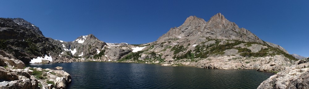
Arrowhead Lake panorama, above the eastern shore
Much of the way back to Love Lake was across open rock. The rock has quite a bit of lichen on it, and when that stuff is wet it can be quite slippery. I more or less was able to retrace my steps but did end up going through a nasty bit of krummholz that I didn’t encounter on the way up. Going through that, I got my pants soaked, which led to my damp socks getting pretty wet again.

Forest Canyon rain squall. Rock Lake visible 700′ below.
I made it back to the outlet of Arrowhead, crossed the stream without incident, and climbed the talus slope up to Love Lake. I went pretty slow, taking great care on the slippery rocks. Up on the shore of Love Lake I let my guard down and nearly slipped on rocks there.
On our way out for the day, we refilled water bottles at Love Lake. Everybody took what water they needed for the afternoon and we left some full bottles and our filter gear there. When I got there, everything was gone, so the guys had already returned to camp. If they quit fishing when the rain started, they had about an hours head start on me.
By the time I returned to camp, the rain had stopped and shortly thereafter the sun was shining brightly. I took the opportunity to take off my boots and socks and lay them out on a rock. Sadly, the sunshine didn’t last long and nothing quite got dry.
The guys told me they didn’t venture far from Arrowhead’s outlet. The park’s website said fish could be caught there, and down below in Rock Lake. The terrain is pretty rugged at there the outlet, and Rock Lake is something like 700’ below. They didn’t catch anything, but all had hits on their lines.
The evening was uneventful. The rain didn’t return before we turned in. Even so, it was an early night with everybody retiring before dark. I slept about as well as the night before; one excursion before midnight and otherwise sleeping in fits and spurts. It rained for about an hour starting at three. No dreams tonight, at least that I recall.