I would say I woke up around 6:00 but that wouldn’t be exactly true. The reality is that I never really got back to sleep after my attempt at astrophotography. I did get some sleep, but for the most part, I just tossed and turned. So it goes.
After breakfast, Gordon and I hit the trail a few minutes before eight. The trail only goes as far as Bluebird Lake, where we arrived in less than half an hour. Yesterday, while sitting on the shore of Bluebird for hours, I pointed out to Gordon the route I used to reach Pipit Lake several years ago and made some suggestions as to how we should attack Isolation Lake.
First, we cross the outlet. Step over three or four rocks in the stream, then climb a crack in the rock on the other side. Even though I did this round-trip when I hiked solo to Pipit, I knew I’d have a little heartburn over the descent back down the crack on the return trip. I’ve done it before, I know I can do it again, so why do I let it bother me? If this is my biggest problem for the day, I’m okay with that.
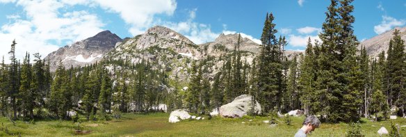
On the north shore of Bluebird is a rather large talus field. We crossed this fairly high up the slope and continued to climb on the other side, staying to the north of where Pipit hikers would go. We were essentially aiming for a spot a couple of hundred yards north of Lark Pond (which we couldn’t yet see) while trying not to get into any of the patches of willow that are in our path. We had soon reached a flatish bench and past any terrain we could see yesterday from Bluebird.
We weren’t entirely able to avoid all the willow and had to power through a few yards of the nasty stuff before coming out on the next bench. Before long, we were at the foot of a rather steep climb across another talus field. Gordon and I took different routes. I think his involved quite a bit more talus than mine. I think the talus could be avoided by swinging farther to the south and that might be an easier route, if a bit longer.
Isolation Lake sits a few feet below 12,000′, about 300′ below the saddle between Isolation Peak and Mahana Peak. The lake is not very large, a bit less than two acres. We paused here for about fifteen minutes, which I spent mostly gazing at the slope we’d need to climb to continue on to Frigid Lake. We’d climb the three hundred feet to gain the saddle and any route would involve a slope angle exceeding 35 degrees. That might not sound too bad to many people, but it’s about as steep a slope as I want to climb. Not so much for the climbing bit as for the descending bit.
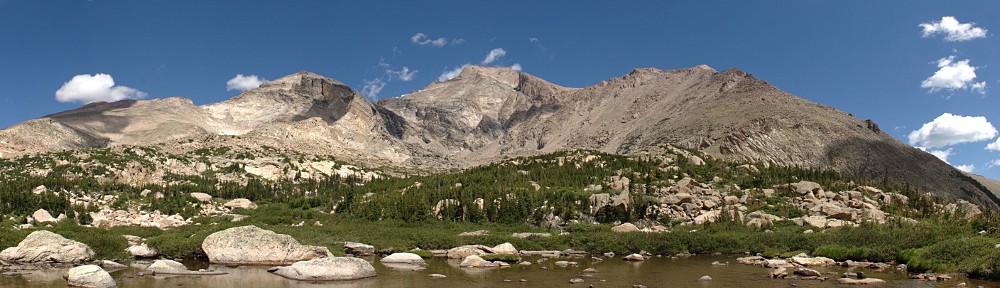
Greeting the hiker upon gaining the saddle is a very dramatic view of the mountains to the north. In the near distance is Tanima Peak, just over a mile away as the crow files. Tanima is dwarfed by the mountains to the north: from left to right (west to east) are Mount Alice and Pilot Mountain, Chiefs Head Peak, Longs Peak, and Mount Meeker.
The slope down the north side of the saddle is somewhat gentler than what we just climbed. It’s a nice stroll across tundra, until the next talus field. Descending across the talus, the slope continues to steepen slowly, revealing that we’d soon need to skirt around a snow field. Grassy bits become few and far between. The final descent to Frigid Lake is down from a small ridge that skirts the south side of the lake. It’s more talus.
It was now nearly noon. We’d been hiking for four hours, mostly off trail, all of it at high elevations, and the last few yards down to the lake are talus. I capitulated. I found a nice comfy spot to take a break and have a snack. Gordon continued down to the shore of the lake. Purists might suggest that because I didn’t dip my feet in the lake, I hadn’t really visited it. I say I was close enough, purists be damned.
I dug through my backpack to find that I somehow managed to leave the GoPro in the tent, so no timelapse video from either Frigid or Isolation. Oops.
After about half an hour, I whistled to Gordon that I was heading back. Gordon is a much faster hiker than I am. No matter how much of a head start I take, he always catches up to me in short order. This time, he caught me by the time I got to the little snow field.
In my planning, I couldn’t help but note that from the top of the saddle between Isolation Peak and Mahana Peak that the summit of Mahana is only three hundred feet higher and it can be reached by making a short detour without dealing with any steep slopes. I have no doubt Gordon could have done it quickly and easily, but it’s a bit too much for me to do both Frigid Lake and summit Mahana. I’m not particularly disappointed that I didn’t even think about summiting Mahana when I was so close.
Just before reaching Isolation Lake on our return trip, we spotted a trio of bighorn sheep ewes. This is only the second time I’ve seen bighorn sheep in the park. Previously it was a large herd of ewes and yearlings and they were a couple of hundred yards away. These three were much closer. We watched them for a few minutes. At first, two of them would keep an eye on us while the third grazed. In the end, they must have figured we weren’t a threat and paid no more attention to us.
Our second break at Isolation Lake was about an hour long. The weather didn’t look too threatening, which can be a risky line of thought here below the Divide. Even with the extended break, I was still feeling the effects of climbing up and down the mountain at more than two miles above sea level. I do fine at nine or ten thousand feet, but above tree line it’s a different story.
The trip back to Bluebird was fairly straightforward. We didn’t exactly follow our route up but managed to again avoid most of the willow. Couldn’t avoid the talus, though, which was really wearing out my legs.
After a short break at Bluebird, I headed down to our camp for nourishment. And a beer. (Today’s beer was a repeat: Left Hand Brewing’s Wheels Gose Round, a delicious sour gose made with raspberry and lemon.)
Bluebird Lake and Me (photo credit: Gordon)
Isolation Lake
Tundra fungus
Mount Alice, Chiefs Head Peak, Longs Peak, Mount Meeker
Frigid Lake
Frigid Lake
What Are Ewe Looking At?
On the Beach
Isolation Lake
Isolation Lake and Mahana Peak
Columbine and Mahana Peak
Back at camp meant back in mosquito central. In that regard, the evening was a repeat of yesterday. Gordon had a bit of fun with it, though. He noticed that the corpse of one of the mosquitoes he had killed had been carted off by an ant. He dispatched fifteen or eighteen more blood-suckers and piled their remains where the ant had found the first one. Had he done this closer to my tent I might have worried I’d have to deal with a line of ants.
Having missed the opportunity to record timelapse videos at the lakes, I ran the camera to see what sort of results I might get by shooting the rugged northern flank of Copeland Mountain. As we had last night and all afternoon, there were some clouds. But they pretty much cleared up right at sunset, so I set an alarm so I could have another try getting a Milky Way shot. Unfortunately, at 11:30 I woke up to high, thin clouds and got right back into the tent.
I’ve been planning this backpacking trip for several years now. The idea is to reach both Isolation Lake and Frigid Lake. It may be possible that I could reach Isolation Lake on a day hike, but after my visit to Eagle and Box Lakes (reached from Thunder Lake), I decided that Foster’s route to Frigid Lake would not work for me. The answer, I decided, was to camp at Upper Ouzel Creek and try to reach both lakes from there.
In fact, I made the attempt a few years ago. It was not well thought out. I somehow decided that a trip in the first week of July would work just fine. There was so much snow. I was able to pitch my tent on dry ground, but the campsite featured several snowdrifts. I didn’t even make it to Bluebird Lake that time, let alone another thousand feet of elevation to Isolation. Needless to say, I took a bit more care in choosing when to make another attempt.
I keep telling myself that, on one of these trips, I’ll try to get a photo of the night sky: the Milky Way. When selecting my dates, though, I don’t give any consideration to the lunar calendar. This time I got a bit lucky. The moon would be in the first quarter and would set not long after the sun. So for this trip, I’ll bring the tripod. It’s an extra four pounds. And, while I’m adding extra weight, why not bring the critter cam? What’s one more pound?
Wednesday, August 3
Gordon decided to join me on this trip and I managed to talk him into driving. I told him that our first day’s hike wasn’t long so we didn’t need to get an early start, but I was concerned about getting a parking spot at the trailhead. The timed-entry passes are in effect for Wild Basin, but only after 9 am. However, I’m sure the parking lot fills up well before then. So it was an early start nonetheless. We arrived a bit before 7:30 to find plenty of available parking.
I’ve described the route to Bluebird Lake in earlier posts, so I won’t repeat myself.
I think I first hiked this trail back in 2008 or so. That would have been thirty years after the Ouzel fire. There’s a section of trail that runs along the top of a ridge above Ouzel Falls to the junction with the spur trail to Ouzel Lake. This section of trail was a bit of a two-edged sword: with no trees, the open views of all the surrounding mountains are impressive, but with no shade, the hiker is subject to the merciless sun.
Today, though, I was struck by how much the trees have grown in the last few years. The once open view is getting closed in. The vast majority of young pine trees are more than six feet tall now. Our two-edged sword is no more: the trees block the views but don’t provide any shade. So it goes.
The Upper Ouzel Creek campsite, by my reckoning, is about a third of a mile below Bluebird Lake. The trail signs indicate it’s farther. It’s a steep third of a mile, though, gaining nearly four hundred feet. I think my favorite part of the trail to Bluebird is a steep section just above the campsite. Maps of the area don’t indicate any switchbacks, probably because they’re too close together to show. Those switchbacks carry the hiker up a slope carpeted with wildflowers. The whole rainbow is represented: yellow flowers make up the majority, but there are red, orange, blue, indigo, and violet flowers, too.
We arrived at our campsite just as the prior occupants were packing up. They were there to fish; they stayed two nights and dipped their lines in both Bluebird and Ouzel, but no luck at Bluebird.
Having arrived at our destination before noon, we had plenty of time to kill. We were done setting up camp and eating lunch by 1 pm and so headed up to Bluebird to sit and relax and watch the world go by.
I was a bit surprised to see several hikers reach the lake after we did. One group, a family of four, stayed at Bluebird until about 4 pm. I guess because I have an hour-and-a-half drive home after my hikes, I want to be back to the car no later than 5 or 5:30. Those folks, if they kept up a good hiking pace, wouldn’t be back to the trailhead until 8 pm.
We hung out at the lake for nearly four hours. The weather seemed to be threatening: the white, puffy clouds grew bigger and darker but we never got more than a few sprinkles. Down the valley, though, it looked at times to be raining heavily. Without wind, it would have been comfortable in shirtsleeves, but it was breezy enough to warrant putting on a jacket.
I’m generally at these alpine lakes for no more than an hour, generally around noon. Being there a bit later and for an extended time I enjoyed watching the shadows change on the surrounding mountains. I ran the GoPro from two different positions, watched a little pika navigate through and around the rocks trying to avoid us humans, and investigated the nearby flora.
Gordon found some remnants of the dam that used to be here. I told him that I’d read about the removal of concrete. I was thinking I’d heard that 1,100 tons of concrete had been removed but was unsure of the number. It’s actually five million pounds of concrete and rebar. That’s 2,500 tons. They airlifted it out in 1989 and 1990 (well before my first visit here). I can’t help but wonder how they got that much material up here. There’s nothing like a road, or the remains of a road, and the dams in the area were all built around the turn of the twentieth century. The material sure wasn’t airlifted in. More on this topic later in another post.
Wild Basin Squall
Pika
Mahana Peak and Bluebird Lake
Backcountry Charcuterie
Night Sky
Had I given it any thought, I might have taken my dinner with me to the lake. As no forethought was involved, we had to return to camp for dinner. The breeze we had at the lake was absent at camp. Normally, this is a good thing. But not tonight. We were besieged by mosquitoes.
I sprayed a liberal dose of repellent on all my exposed skin. This was only a partial solution. Before long, I applied a second coat and sprayed my clothes as well. These measures made it so the little buggers didn’t land on me, but it didn’t keep them away from me. From our arrival back at camp until dark, when I retreated to the tent, there were never less than a couple of dozen mosquitoes buzzing within twelve or fifteen inches of my head. While eating, I had to be careful not to ingest one accidentally. These mosquitoes were relentless.
Today’s beer was a Colorado Native Palisade Peach tart ale. Delicious.
Until dark, I kept a close monitor on the cloud situation. Several times it seemed like the clouds were finally breaking up, only to have another batch of them appear over the divide. By dark, I decided that the sky would soon enough be cloud-free, so I set an alarm for 11:30. I figured the quarter moon would be down by then, the skies would be clear, and I’d be able to try my hand at astrophotography.
I was in luck: the skies had cleared. At least, I think they did. There may have been some high, thin clouds in the east. I had a couple of suggestions for exposure settings. I tried them, and a few others. It took only a few minutes, and I was back in the sack before midnight.
But I never really got back to sleep.
Finally, here’s the first timelapse of the trip:
The Data
I’ve been recording how long it takes me to hike from point A to point B for quite a while. I share the timetables so somebody else might be able to get a clue how long it might take them. In the table below, for example, someone who has gone to Ouzel Falls but not to Ouzel Lake can compare how long it took them to reach the falls to my time. Whether they were faster or slower to the Falls, they can extrapolate a time for the hike to the lake. Also, next time I hike any of these sections of trail, I’ll have a good idea of how long it’ll take.
Location
Arrive
Depart
Trailhead
7:25 am
Campsite shortcut
8:00 am
Calypso Cascade
8:14 am
Ouzel Falls
8:45 am
9:09 am
Bluebird/Ouzel trail jct
9:21 am
Ouzel trail jct
10:12 am
Campsite
11:40 am
Arrival time and departure time are the same where no departure time is given
It didn’t really occur to me that I could use times from one hike and forecast how long it might take me to do another hike. Certainly, there are many factors. How steep is the trail? Am I carrying a backpack or a day pack? What’s the elevation? Am I on a trail or bushwhacking? How long was I hiking prior to a specific section – how fatigued am I?
We awoke to another beautiful day in the neighborhood. That is, I should say “I awoke” because Gordon had a sleepless night.
Last night when I hit the sack, I plugged my phone into my battery. For some reason, the phone insists on being powered on when it’s charging. It read 46%. A few minutes later, it read 47%. Good, it’s charging. When I woke up, the phone was at 0%. The cable had come undone and the phone just ran down.
This is a bit of a problem. The phone is my only camera. The SLR, which failed on the Renegade trip, was still not back from Canon. I plugged the phone back into the battery and set it on a stable base. It got up to 38% by the time we hit the trail a bit before nine.
This might be the time for peak aspen in the Park, I don’t know. There aren’t many aspens in the valley. It’s all pine, so you might not expect much color. You’d be wrong. In this pine forest, the autumn colors are on the ground. The leaves go from green to green and yellow to yellow to gold then a bright red and finally to a dull brown. Sometimes large areas are all one color, sometimes all the colors show up within a few feet.
In a pine forest, autumn colors are on the ground, not in the trees
I’d said that we’d be to Nokoni in an hour (which is what it took yesterday) and to Nanita an hour after that. As expected, it did take an hour to reach Nokoni, but we made it from Nokoni to Nanita in forty minutes. None of that territory was new to me. I had also said it would take another hour to get to Catherine. That turned out to be quite optimistic.
We made our way across Nanita’s outlet and quickly found a game trail. I thought of yesterday’s ranger calling them “moose trails”. I’m not sure why I found it amusing, but I did. You know you’re on a good game trail when you keep finding poo. Elk pellets and moose patties.
It didn’t take us too long to get out in the open. There are three great cirques between Ptarmigan Mountain and Andrews Peak. To our right we had a nice view of the one closest to Andrews. The ramp we were climbing got pretty steep. I took my time, often checking out the view behind me.
Lake Nanita and Ptarmigan Mountain
The top of the saddle is 600′ above Nanita. Catherine is 800′ below us, but out of sight around the corner. Directly in front of us, about a mile away, is a pass, another saddle. There’s a small pond there, a couple of hundred feet below the top. A century ago, there were plans to make a trail connecting Spirit Lake and ‘Lake Catherine’. Presumably, that is where the trail would have gone.
There at the top Gordon and I parted ways. He wanted to take a more direct, slightly steeper route to Catherine. I opted for the longer, shallower arc, out of the trees. It was nice, easy walking for the most part, generally following game trails. Only as I approached the lake did I need to get back to the edge of the trees to avoid giant boulders.
‘Lake Catherine’ from the southwest
I got to Catherine at 12:30, so three and three-quarters hours. I found Gordon, who said he hadn’t been waiting long. But he is a patient man, so he may have been enjoying the wait. We scouted the northwestern shore for a place to snack and relax in the sun but out of the wind.
We spotted a promising place nearly opposite us, but on closer inspection, the trees there were swaying pretty good in the wind. We continued along the shore. The spot we eventually picked was pleasant enough, a few chill gusts excepted.
‘Lake Catherine’ as seen from the outlet
Gordon couldn’t resist pointing out that he put all this effort into getting to one of the least visited lakes in the Park, only to find me there, too.
After our relaxing picnic, we started our bushwhack. I have a good idea that Foster would call it an “arduous bushwhack”.
One of the great things about hiking at this time of year, other than the fantastic colors on the ground, is that everything is much dryer. All the streams are running quite low and are much easier to cross. The grassy marshes are more grass than marsh now. This would be much more difficult earlier in the season when it’s all wet.
According to the map, it didn’t matter which side of the outlet we descended until we came to a pond two hundred feet below the lake. At this pond, we’d need to go down the right side to avoid some steep terrain. We had good game trails and there wasn’t too much deadfall.
Unnamed pond below ‘Lake Catherine’, looking back the way we came
Below this pond, things got interesting. It was easy going when we had game trails to follow, but we started coming across denser deadfall. We didn’t worry too much about staying close to the stream, all we had to do was go downhill. Maybe half an hour after leaving the pond we came across a stream. I thought, “Ah, a tributary!” But checking the map, we’d arrived at the North Inlet. Although the stream we’d been following from Catherine carries about the same volume of water as the stream that flows from Lake Powell, it’s farther to Lake Powell, so that stream is the North Inlet while the one we’d been paralleling has no name.
We didn’t need to cross the North Inlet so we didn’t. Yet. We followed it for just a few yards before returning to our unnamed stream. This we crossed. After a while, we decided that the “grass was greener” on the other side of the North Inlet, so we crossed it. This we did a few times before we were done.
Once, on the north side of the stream, our game trail petered out in a mass of deadfall. We were working our way slowly through here when we heard an elk bugle. I asked Gordon how far away he thought that was. A few minutes later through the trees he spotted a bull and some cows about a hundred yards ahead of us, crossing our path, headed uphill. The bull stopped and bugled. Given how far the sound travels, I expected it to be much louder. Another bull some ways behind us bugled a response. How close was he?
We worked our way through the deadfall and had easy going for only a short distance. We entered another pile of deadfall. This one, though, was different. Instead of the trees lying in random directions, here they were all facing one way. And the dead trunks weren’t still connected to their roots. The roots were still in the ground, with stumps two or three or four feet tall, splintered. This is an avalanche debris field.
Crossing the North Inlet for the last time, we began searching for Lake Solitude (not to be confused with Solitude Lake, in Glacier Gorge). This is a small forest lake with no inlet or outlet. In the proximity of Solitude, the stream meanders through a large open meadow. We wandered around a bit, backtracked a little, made at least a token search for it, but didn’t stumble upon it.
The rest of the way back to camp, there weren’t any serious obstacles. There weren’t that many game trails, either, but so it goes. Before we knew it, we spotted Gordon’s hammock. Home again, home again, jiggety-jig!
We left Catherine a few minutes after one and arrived in camp at 4:30, so we managed about a mile an hour. I’ve done worse. My trip to Julian Lake a couple of months ago had some brutal stretches. And up Spruce Canyon with Gordon last year we could only manage half a mile an hour.
To celebrate the completion of our little odyssey we drank the rest of the beer Gordon carted up and had dinner. The skies weren’t quite clear, just some thin, high clouds; a lacy veil that slightly diffused the light of the gibbous moon.
Before dusk, another helicopter flew over. It followed the trail up the mountain towards the Divide. A few minutes later we heard another chopper, but couldn’t spot it. Maybe it was the same one, on its return trip. This was not the cargo helicopter, I think it was the same kind as the one I saw on my Hunters Creek hike – a rescue chopper.
Not long after, Gordon spotted a blinking light on the mountainside across from us. It was random, intermittent. It didn’t take us long to see that it was not one but several lights. We discussed it: we agreed it probably wasn’t aliens, and elk don’t generally carry lights. It had to be people, right? What were they doing up there, wandering around like that? Was it a search party?
Well, I didn’t print a map of that part of the trail. We weren’t going that way, and I didn’t pay particular attention to the layout of the trail. I knew there were a couple of large switchback sections, but thought they were farther up the valley, out of our sight. I was wrong. The first switchbacks, climbing six hundred feet, were directly in front of us. We’d been watching a group of six or eight hikers work their way down the mountain on the trail.
Tonight, Gordon gave up before I did. I wasn’t as cold as I was last night, so wasn’t in as big of a hurry to climb into the warm sleeping bag.
We didn’t see another person all day.
Saturday, September 26
I took my obligatory excursion at one. The thin veil of clouds was gone, the air was calm.
We were packed up and on the trail a bit before nine. It took us four hours to hike in, we should be able to beat that by a bit on the way out. On most backpacking trips, the pack weighs heavily on my back on the hike out, but today I felt pretty good.
We ran into another ranger. This one was hiking in. When we came upon him, he was talking to a woman backpacker on her way out. We chatted a bit. I asked if there was some search operation last night. There wasn’t, so we were seeing hikers. The woman somehow knew that a group had gotten a late start. They didn’t make it to camp (or out? I’m not sure) until 11:00 pm.
We told him we’d been to Catherine. He said, “People used to walk all through these forests twelve or fifteen years ago. Not as much now; there’s too much deadfall from the pine beetle.” He told us he was working “pre-rescue”. He was on the lookout for people “wearing flip-flops and not carrying any water.”
As we got closer to the trailhead, we encountered more and more hikers. At first, I was counting them. Once they started coming in groups of four or six or more, I switched to counting dozens. In the end, I figured it was 8 or 9 dozen. I couldn’t help but wonder where they all parked. I don’t think there’s room for much more than a dozen cars in the lot. (Most of them were parked on the paved road a quarter-mile below the trailhead.)
I did get a bit of a kick from some of the questions people asked me. “Did you make it all the way? All the way to the falls?” The falls are the first point of interest on the trail. Yes, I made it “all the way”. Another one saw my big backpack and asked, “Are you backpacking?”
Back at the trailhead, I was happy to be done.
But, boy, what a satisfying trip! The weather was great, the scenery awesome. I felt great the whole time. We saw an elk bugle, marveled at mysterious lights, and went to one of the least visited lakes in the Park.
My third and final backcountry permit is for the 24th and 25th at Pine Marten, the campsite at the base of the spur trail to Lake Nokoni and Lake Nanita. I’ve been to both of them on day trips. Once to Nanita and once failing to reach Pettingell Lake. This time, the idea is to get to ‘Lake Catherine’, the officially unnamed lake highest in the valley between Andrews Peak and Mount Alice.
The Foster Guide says it’s 12.8 miles from the trailhead with an elevation gain of 1,800′. This is not a fair description. Her route is from Lake Nanita, which has the hiker crossing a ridge at just over 11,000′ and another that reaches nearly 11,400′ to get to a lake at only 10,600′. There is another way to get there without gaining and losing so much elevation: follow the stream.
The Pine Marten campsite is at something like 7.8 miles in, and sits at 9,500′. The route via Nanita, then, is five miles and climbs a total of 2100 feet. The bushwhack is maybe 3.5 miles and gains about 1000 feet. The Nanita route is quite scenic and navigation is trivial. The bushwhack route is through dense forest with few views and constantly challenging route-finding.
After pondering for some time, I decided a loop might be the best way: take the Nanita route to get there and bushwhack on the return trip. As a bonus, it should be easy to pick up Lake Solitude.
Thursday, September 24
Gordon drove; we had our choice of spaces in the small parking lot at the trailhead and were hiking before nine. It was a beautiful morning, with some high, thin, wispy clouds. There was a fair amount of haze when you faced the sun, but a nice, deep blue with the sun to your back. No breeze to speak of.
Just a few minutes after passing the cabin at the Park boundary we heard our first elk bugle.
Not long after that a helicopter flew over. It was a cargo chopper, with counter-rotating blades. It wasn’t carrying anything. A few minutes later, it came back down the valley. This was the first of what ultimately was five round trips. After the empty run, it had what looked like a telephone pole dangling vertically; something as big as the telephone pole, but carried horizontally; a pallet stacked with large crates; and finally two nets full of smaller items.
This last drop we had a sort of front-row seat. Just before reaching the stringer bridge that crosses the North Inlet, we were stopped by a ranger wearing a fluorescent vest: “You have to wait here a minute.” They’re staging the materials to rebuild the bridge. The work won’t get started until next summer, but they said they were lucky to get helicopter time, given the demands of the Cameron Peak fire.
We chatted with them a bit. One gal had worked on the crew doing the big boardwalk project on the Onahu Creek trail. She said they still had three weeks to go. Another ranger said he’d been to Catherine. I asked if he went from Nanita or up the creek. “Up the creek. Not much deadfall.” Gordon heard “Lots of deadfall.” In any event, it confirmed the “Nanita there, bushwhack back” loop was doable.
Cargo drop
We learned that the first, empty, trip of the helicopter was to hit the landing zone with its prop wash, knock anything loose out of the trees. The landing zone wasn’t a natural occurrence: it looks like they cut down a number of trees.
The bridge is looking pretty sad. There are a couple of patches on it, but it looks like a careless horse could break a leg. The materials they dropped looked to be an upgrade from the existing structure. I believe the current bridge is the second one, built in the 1970s.
Our campsite was just a few more yards up the trail. There are two sites here, we took Pine Marten #2, the higher of the two. Google maps has the location of the campsite wrong. I like the actual location over Google’s misinformation. It’s right on the North Inlet. Very easy access to water, and I find the sound of the rushing water quite pleasant.
We made excellent time, averaging a bit less than two miles per hour. It is a fairly mellow trail; when I day hiked it, I managed two and a half miles an hour. This is the longest stretch of trail in the Park that I can maintain that pace. Having arrived so early, we headed up to Nokoni. Then, depending on how I felt, we could possibly visit Pettingell.
They need to send a crew up this trail with a saw and clear the deadfall that blocks the trail in several places. The first, and biggest, was just below the campsite – we had to navigate that with the big packs.
It took us an hour to get to Nokoni. I decided I’d rather lounge about the lake than hike another two hours and climb a steep 500′ slope. Gordon thought the extra hiking was just the thing and headed off up the slope. I found a spot on the opposite shore and followed his progress. He made much better time than I could. Before he left, he told me he’d signal me from the top to tell me whether he’d continue on down to the lake or abandon the quest. I watched him climb most of the way but lost him just before he got to the top, so I don’t know what he signaled.
Lake Nokoni
Ultimately, he was gone for an hour and a half. He put eyes on the lake but didn’t quite get there. I think I made a sound choice. It would have been more like two hours for me. I might think differently had Gordon made it, but I was comfortable with the day’s effort.
On the way back to camp we ran into a solo hiker. He was wondering if he could make it to Nanita. He was staying well below us, back by Ptarmigan Creek, at either Ptarmigan or Porcupine. Given how far he had to go back, I suggested that going to Nanita might put him in the dark before he got back to his camp. He told us he’d bought a permit for Lost Lake, but due to the Cameron Peak fire, they moved him to Porcupine.
Back to camp at 5:15, we chowed down and chatted and had a beer. It had been a nice, warm day all day, calm, very pleasant. The wispy clouds were gone by mid-afternoon. When the sun went down, it started to cool down fast. Before long, I was wearing nearly everything I brought: long underwear, t-shirt, sweats, hoodie, and the rain jacket on top of all that. A few minutes after eight, I called it quits and climbed into the tent and sleeping bag. It took me a while to get warm.
By the time of my inevitable nocturnal excursion, the quarter moon had set and the stars were shining brightly. I didn’t see the Milky Way but I could see the light pollution from Denver.
Imagine a verdant shelf set high on a stately mountainside above an unspoiled, heavenly creek valley. Add a series of lovely lakes to ornament the shelf and place it in a location so remote that few humans would ever have the ambition to go there. Put it all together and you’ve got Ten Lake Park.
— Lisa Foster
I studied the map of the terrain between Lake Verna and Ten Lake Park for quite some time. The first thing I noticed is that there aren’t ten lakes in Ten Lake Park. My map shows only five. And three of those look more like puddles than lakes. Regardless, it looked to me that I might be able to reach the place. I know that a forty-foot contour interval on a map can hide a multitude of terrain that might give me difficulties. But half or a bit less of the way was in forest so route finding should be simple for much of the way.
Tuesday, August 18
We had another leisurely morning. I slept until nearly 7 and we took our time with breakfast. We started off at about 9:30. The smoke cleared considerably overnight.
The obvious route from Lake Verna to Ten Lake Park is to follow an unnamed creek up the eastern flank of Mount Craig. Once out of the trees, look for the pass between the two prominent points east of Mount Craig. Cross the pass and descend into Ten Lake Park.
Rather than backtrack the quarter-mile to the creek, we crossed East Inlet west of the creek and went up the slope toward the creek at an angle. It was fairly steep for my taste, but there wasn’t much deadfall. Still, it was slow going. We came to a bit of a cliff that we bypassed by crossing the creek. After crossing the stream again, there was a big section of slick rock we had to cross that bothered me. I knew I’d be able to go down it but I also knew it would have my heart rate up.
We often looked back at where we’d just been, making sure we got a good look at the route from this vantage. Ed stacked up some cairns as bread crumbs. He used a couple chunks of wood as a marker where no stones were available.
Mount Craig on the right, our route to the left
As we climbed, the forest thinned and receded from the creek, which ran through a grassy meadow filled with wildflowers. Most were still blooming nicely, but the Elephant Heads were past their prime.
We saw only a few small lingering drifts of snow. Earlier in summer, these grassy areas are filled with water; big spongy masses. But now that the snow has melted and we’ve had about half the normal precipitation this year, things are dry. Judging by the watermarked rocks, the creek was running at a small fraction of its spring flow.
Not long after coming out into the open, we came to a gully on our left that climbed quite a way. I suggested that what we saw was the pass we were looking for. This proved to be a … well, not a false summit but a false pass. We weren’t so much looking for a gully as a grassy ramp. When we got to the top of our false pass we spotted the real thing.
Or, more accurately, a choice of passes. We could continue up and left, climbing a wide grassy area or a slightly steeper, narrower, rockier one a bit to the right. It looked like the one to the right was a bit lower and would be a few steps shorter, so that’s where we headed. It didn’t take us long to reach the top and take in the view of the other side.
Ten Lake Park
I knew going into this that there aren’t actually ten lakes in Ten Lake Park. And I know that these sorts of places can look considerably different in, say, June than in mid-August in an abnormally dry year. A little trickle of water emerged from a nearby spring, making a narrow band of green across an increasingly brown expanse. Below us, we could see a couple of small lakes and ponds, along with two dry lake beds.
In an ideal world, we’d have taken some time to enjoy the place, but it was approaching 1:30 pm, and assuming it would take about as long to return as it did to get here, we’d be back in camp well after 5. So, after a quick reconnaissance of the upper reaches of the park we turned around and climbed back to the pass.
Our view of Mount Craig as we descend
The descent down the slopes and gullies was fairly quick and painless and once back into the upper reaches of the forested slope below us, we came upon the first of the cairns we’d set up earlier. We successfully found our route in, and Ed knocked down the cairn as we passed it.
Approaching the top of the slick rock we crossed on the way up, we made a change to our route. On the way up we saw a game trail at the top of this rock. Deer and elk won’t often cross rock like this and we figured it was worth a shot at following the game trail. As often happens with these things, it looked good for a while before petering out. But we continued to go down the steepening slope, climbing over the occasional dead tree trunk, regaining and re-losing game trails on the way.
It sometimes seemed these game trails haven’t seen much use lately, but there is game in the vicinity. We came across some deer in the upper meadows and here in the forest we came across a cow elk with two or three calves still in spots. We didn’t spy any moose, but there was ample evidence of their passage, and I don’t mean footprints.
Ed is a big fan of glacial knobs. At one point in our descent we had a very nice view of the opposite slope, which is the southern exposure of Andrews Peak. To Ed it must have looked like glacial knob heaven.
As on our way up, we crossed to the west side of the stream on the way down. This time we didn’t recross it and stayed to the west. The slope was not quite as steep here, and we had a relatively easy time of it. Before long, we saw the East Inlet just below us. The stream is wide and shallow here and Ed just headed straight across. I’d have followed, but I don’t hike with poles and without poles I’d have undoubtedly slipped so I went upstream to find a crossing more to my liking.
Our return trip was quite a bit faster, taking only two and a half hours. In retrospect, we could have spent a bit longer at Ten Lake Park. But the future is hard to predict, and we did start getting rained on a bit on the lower portion of our descent. I’m not at all unhappy with our little hike.
I found the upper area of this unnamed valley beneath the eastern flank of Mount Craig quite beautiful. Add a small lake here and it might even be ideal, but I’m a big fan of alpine lakes so I admit my bias.
It should come as no surprise that we encountered no other people on our little trek. In fact, we saw no sign that people had ever walked here before us. At some of my more remote destinations, I wonder how many other hikers make the trip in a year. I often see cairns or bootprints and surmise dozens or maybe a hundred. Here, perhaps only a handful of people come through here each year.
Because we were back in camp a little earlier than planned, we had a bit of an extended evening. Although the smoke from the wildfires was quite mild in the morning, it had steadily increased throughout the day. Now it was quite thick. I couldn’t taste it yet, but the odor was very noticeable.
The late afternoon saw a succession of rain storms. That overstates it a bit: we got sprinkled on several times. The smoke made it nearly impossible to tell if clouds were overhead, but we were still seeing our shadows, so we kept telling ourselves that the rain wouldn’t last. It never did, and the little rain had no effect on the smoke.
In fact, it might have been tempting to think that our sprinkles of rain had somehow turned to a light sprinkling of snow. But it wasn’t snow, it was ash. Each little particle of ash was rectangular, rather than the hexagonal shape of an individual snowflake. Like snow, sometimes the individual rectangular ashes clung together making larger bits of ash.
The big fires that I was blaming for the smoky air are well to the west of us. The nearer fires are north and south. And so I was quite surprised to note that the ash was falling on us from the east. I’m guessing that this was ash from the Cameron Peak fire, which is the nearest one, and so the complex winds along the Continental Divide carried this payload east, then south, then west.
The ash fell all evening, but the smoke thankfully never got much worse.
We nearly went the entire day without seeing or hearing another person. Sitting in camp chatting, we heard nearby voices. I climbed to the top of a rock where I could see the trail along the shore of Lake Verna and spotted one hiker. Unless she was talking to herself, there was at least one more hiker. Nonetheless, I can’t think of a day in the Park when I saw so few other people.
As the sky darkened and the stars started to appear, we could tell that all the clouds were gone now, we would get no more sprinkles, and if ash was still falling we could at least no longer see it.
Wednesday, August 19
We awoke to another beautiful RMNP morning. Like yesterday, the smoke was much reduced. And no more ash was falling.
We were packed up and on the trail not long after eight. We made somewhat better time on the way out and were back to the trailhead at about 2:30. In all my years of hiking the Park, I can probably count on one hand the number of times I’ve seen horses on the trail. I see lots of road apples, but not many horses. In addition to the two horses we met while on our break on Devil’s Ladder on Monday, today we were passed by two park rangers on horseback, leading two pack horses. And closer to the trailhead another pair of riders. I think Ed was trying to work out how big of a bribe it would take to ride out rather than to walk.
At the trailhead, there was a ranger picking up litter. It’s sad that this is a part of anybody’s job. Why do people go looking for wilderness and then promptly pollute it?
Another ranger was at the trailhead checking timed entry passes. This trailhead isn’t outside the Park, but you don’t have to go through an entrance station to get here. When we arrived on Monday there was nobody performing this check.
Ed stopped in Grand Lake for some ice cream before we re-entered the Park for the drive over Trail Ridge. Approaching the entrance station, Ed’s ice cream cone suffered containment failure and he nearly wore the last few bites.
To the north were the smoke plumes from the Cameron Peak fire. The smoke blew to the east, and when we descended down the east side of the Divide we drove down into quite a thick soup. Some rain clouds made it look even darker but a look over our shoulders when we passed Deer Mountain showed us that the smoke here was much, much worse than we dealt with on our hike.
Final Thoughts
I’ve hiked the East Inlet Trail three times now, once as a day hike, once with a one-night stay, and now with a two-night stay. I’ve visited all the places along this trail that interest me with the exception of Adams Falls, which is the easiest feature to visit on this trail.
In general, the valley of the East Inlet is a beautiful place to visit and worth the effort of climbing all those stairs. And Devil’s Ladder is a dramatic piece of trail offering an expansive view of the Grand Lake area.
More specifically, our visit to Ten Lake Park was a bit of a challenge but, I think, well worth the calories burned.
My second backpacking trip of the year is a two-night stay at the Lake Verna campsite. This is very similar to my trip two years ago when Gordon and I stayed one night at the Upper East Inlet campsite with the goal of bagging Fifth Lake. That was the trip where I learned I need to spend two nights in camp instead of one. One day to hike in, a day to visit whatever the real goal of the trip is, and a day to hike out.
In that earlier trip report I went on a bit about the condition of the trail. Specifically, that there are an almost uncountable number of stair steps to negotiate and there are quite a few impressive retaining walls and bridge abutments. It’s what I would call a “highly engineered trail”. Rather than repeat that, I’ll go into some of the trail’s history. Much of this info comes from an application the Park made to get the trail into the National Register of Historic Places.
Unlike the North Inlet and Tonahutu Creek, the East Inlet doesn’t offer any sort of easy route from Grand Lake over the Continental Divide. Which is to say that before about a century ago there were no existing trails through the valley. According to Charles Edwin Hewes, a local who wrote about his tramp through the valley, no feasible trail existed there in 1913. That summer, the Estes Park Trail (before it was the Estes Park Trail Gazette, I guess) said that “a new trail was made from Grand Lake to a chain of lakes six miles east of Grand Lake.” It would seem that this could only be describing the East Inlet.
The Trail does not name a trail builder, but in those days trails were often made by lodge keepers, guides, or other locals. Just because Hewes didn’t find a trail doesn’t mean one didn’t exist. It could mean that the trail was a more casual, less permanent style of trail that Hewes and his hiking group could have missed. Lodge keepers weren’t professional trail builders and didn’t have the resources for developing sustainable trails.
In 1919, Roger Toll, who would later become a superintendent of RMNP, recommended that mountaineers who wanted to get up the valley should just follow the waterway rather than to find a trail. In 1922, when he was superintendent, Toll reported that the trail was blocked by a rockslide near Lone Pine Lake. One would think that he wouldn’t report a trail closure unless there was a trail there. Park records don’t mention any trail construction there between 1919 and 1922.
By 1923, the East Inlet Trail had gained some popularity with the tourists. It also gained a bit of a reputation for being dangerous among local guides. The section called “Devil’s Ladder” was notoriously tricky for horses. Fred McLaren, in his first year as ranger, watched his horse slide over Devil’s Ladder and down the hill. I’m guessing it wasn’t one of the steeper bits, as the horse was just a little spooked. McLaren went to the superintendent (Toll, I believe) and suggested that if the Park supplied the food, locals would volunteer to do the work. In 1924 and 1925 such a crew built a new trail through the Devil’s Ladder area and made a handrail out of pipe. That handrail is long gone but the careful observer will note a couple remnants of it today.
In spite of McLaren’s efforts to build a sturdy, sustainable trail all the way to Lake Verna, in 1931 the entire trail was considered “poor”. In 1931 and 1934, trail workers redeveloped the section between Lone Pine Lake and Lake Verna. I don’t know how much of the work was done in 1931 as opposed to 1934, but I suspect the bulk of the work was done in 1934. This section is remarkable today for it’s extensive dry-rock walls and intricate bridge abutments. In the summer of 1934, Roosevelt’s Public Works Administration funded two shifts a day to make these improvements.
In 1935, there was some interest in connecting the East Inlet Trail to the North Inlet Trail. This would have been accomplished by a route over the saddle between Mt. Alice and Andrews Peak. A survey was completed, but given the great distance from both trailheads, it’s not surprising that this was never done as it would get very little traffic.
Another big improvement project was completed in 1940 when the Civilian Conservation Corps worked on the section between Adams Falls and the Devil’s Ladder. Then in 1970, another $70,000 project was implemented. This was mainly for improved sustainability rather than any realignment of the trail. Many older rock walls still remain, although the pipe handrail at Devil’s Ladder was removed at this time.
The official Park trail ends at Lake Verna, but an unimproved and unmaintained “fisherman’s” trail continues on to Spirit Lake, Fourth Lake, and Fifth Lake.
Which brings us to…
Monday, August 17
I reached out to Ed a couple of weeks in advance. I talked him into meeting at his place and having him drive to the trailhead. I said that because we had all day we didn’t need to get too early of a start. So I told him I’d be there at 8 am. He said that would be okay, but pointed out we’d be hiking in the heat of the day.
The other concern had to do with smoke. Specifically, from either the Cameron Peak fire, burning just north of the Park, or the Williams Fork fire, which is a bit farther from the Park and to the southwest. The prevailing winds blow from west to east, so I didn’t expect smoke from those fires, but I did expect smoke from the larger, more distant fires at Grizzly Creek and Pine Gulch. I may have been a bit cavalier about the smoke: I suggested that if it was too bad, we’d just cut our trip short.
We were on the trail just a few minutes after 10 am. The weather was sunny and warm, with isolated clouds. The smoke wasn’t too bad. It was much worse in Denver on Friday, where visibility was quite limited and I could taste the smoke when I was in my back yard. Today I couldn’t smell it, let alone taste it. But it certainly didn’t look good.
Having all day, we made a leisurely time of it. We stopped for a lunch break halfway up Devil’s Ladder. We were in a relatively wide spot. Most of that section is quite narrow, particularly in these days of COVID. But we found a spot with a view that was wide enough to not cause a problem. And we put that to the test when two horses came up the trail. They were able to pass us with no difficulty. We took another break at Lone Pine Lake and even spent a few minutes admiring the stonework on the walls and bridges above Lone Pine Lake.
Climbing Devil’s Ladder
It was about 6 pm when we arrived at Lake Verna. There, we met two young men lounging by the water. They asked if we were staying the night and volunteered that they were camping at the Lake Verna campsite. “That’s our camp,” I told them. Ed and I went up to the campsite where we found their hammocks and gear all set up. There is only one campsite here, and it’s ours. When they came up from the lake I asked them if I could see their permit.They were supposed to be at Upper East Inlet.
We chatted a bit while they packed up. I felt a bit bad, but not that bad. It only took them a few minutes to get their stuff together. While they were packing they told us they’d just graduated from college and were making their way across the West. After RMNP they’d visit Flaming Gorge and Yellowstone. They had no reservations, but would take whatever was available when they arrived. That’s how they got Upper East Inlet. I’m a bit surprised it was available. I’m pretty sure it wasn’t available when I made the Lake Verna reservations back on March 2nd. Somebody probably cancelled due to COVID and these gents benefited.
Calm and somewhat smokey Lake Verna
In spite of our relaxed pace on the hike in, we were both pretty tuckered out. I managed to remain conscious quite some time after sunset. There’s not much sunset to see from here, being obscured by mountains and trees, but through some of the trees we could see the decidedly orange tint of the sunset. Until the stars began to shine, I wasn’t sure whether we had “clear” skies or clouds. Once the stars started coming out, we could tell there were no clouds. The stars directly above us twinkled normally, but those just above the nearby mountains were tinted orange from the smoke.
I was awakened at about five by the patter of rain falling on my tent. It stopped after twenty minutes or so but returned for shorter showers at six and six-thirty. The rain was light enough that by seven, nothing was wet except my tent’s rain cover, not the rocks, not the stumps, not the logs.
The plan for the day was to first visit Murphy Lake. After that, we figured we could head north across the tundra to get a look at Spruce Canyon from above, to see Rainbow Lake and Irene Lake, which I failed to reach last year. Finally, given enough time, we could perhaps even summit Sprague Mountain and take a gander at Lonesome Lake. It’s good to have goals, even if sometimes one’s reach exceeds one’s grasp.
We had a short (very short) discussion as to whether the best way to Murphy Lake was to bushwhack along a straight line down one side of the valley and up the other or to take the trail to a point a bit above treeline and contour around to it. In my map study, I never considered the first option; Gordon brought it up. It’s good to have options. But in this case, I felt it would be much simpler (and perhaps easier) to go with Plan A.
So we left camp at eight, putting Plan A into motion. The Tonahutu Creek trail here is surprisingly busy. It’s not the sandals and no-water people and it’s not day-trippers: everybody we saw on the trail was backpacking. And I’m pretty sure the smallest group we met was four people. We didn’t meet all the people we saw on the trail; we spotted quite a few hikers when we were a fair distance off-trail.
We followed the trail until we were at about 11,600′ elevation then headed more or less southwest. The map shows a couple of streams we’d need to cross, which is never a problem here above the trees. We would also pass by two unnamed ponds. Looking at the map, it seemed the best way to go would be to cross this second stream below the lower pond and follow the contour.
Somewhere in here, I lost Gordon. One minute he was right behind me, the next he was gone. I made a brief search before continuing on my own. He has a map and he knows where we’re going, so I didn’t worry about him.
The upper unnamed pond
I reached one of the ponds and decided that I was exactly where I wanted to be. Then, a few minutes later, I saw that I had crossed the outlet stream of the upper pond rather than the lower one, so I was forty feet higher than I planned. I adjusted my route a bit, then found myself at the top of a large talus field. “Talus” probably isn’t the right word. The rocks at the top of the field, beneath a rock outcropping, were giant boulders and thus much more difficult to navigate.
The lower unnamed pond
That’s when Gordon reappeared. He suggested we work down some more and pass below the boulders. He found an easy route, and we were back in business. We crossed a series of alternating fields of talus and grass. The grassy bits were probably flowing with water a week ago. Now they were mostly dry. The grassy bits aren’t like your lawn. The grass grows in tiny hillocks; tufts of grass standing eight to twelve inches proud of the ground, almost like grassy toadstools. When wet, there’d be flowing water between them. Best to step on them rather than between them.
From the map, I was expecting the whole route to be above the trees. This was not the case. There were trees, but not many of them. They stood in small groups that were widely separated. They served as navigation aids and allowed us to more easily judge distances. There was no krummholz, and what little willow we encountered wasn’t more than a foot tall and had many passages. The whole way, the only difficult bit was the short section of boulders we had to go around.
First glimpse of Murphy Lake
We arrived at Murphy Lake at 10:30. It is nestled beneath the five hundred foot tall cliffs of the northern arm of Snowdrift Peak and a permanent snowfield. Just as we arrived, we heard the crashing of rockfall – rumble, crash, rumble. It took a few seconds to stop. We’d have had to be looking in exactly the right spot to see it, and localizing a noise in this echoey place is very difficult.
Murphy Lake
We only relaxed here for half an hour, as the next leg of our tour would be above treeline. And it’s generally a good idea to get back into the trees early in case the weather gods decide to throw a thunderstorm in honor of your presence.
Wanting to avoid the one difficult spot we passed through on our way here, we took a slightly different route. We found a nice grassy ramp down with a grassy looking gully up the other side. I’m not generally a big fan of giving up elevation only to regain it, but it looked like a pretty good route. It turned out to be the outlet of the lower pond, so we were now on the route I was hoping to take on our way in.
We refilled our water bottles from one of the many rivulets, about the purest snowmelt water one will ever find, just meters below the source. From here we spotted a bull moose in a grassy/marshy area below us. Could this be the same bull I spotted when getting water last night? I wonder just how big the moose population is around here, and how far each moose might range.
We could also see hikers on the trail in the distance. With his binoculars, Gordon counted nine people in the group. We weren’t so much interested in locating the trail as crossing it, and our only real concern there was picking the easiest way to the saddle that overlooks Rainbow Lake. We identified this fairly easily and set off.
The walking wasn’t difficult. Route finding is fairly trivial here at the top of the world; there are no hidden terrain features. But we were somewhere near 11,600′ above sea level, and headed to a point 700′ higher. I’m not a swift hiker in this environment. One might be tempted to make a joke about the air being thin enough to provide less wind resistance. That joke won’t fly, particularly today, when the wind is blowing steadily at thirty or forty miles per hour.
Rather than reaching a spot with a view of Rainbow Lake, we climbed only about another hundred feet to hit the somewhat lower saddle to the right of it. This gives a view of Spruce Canyon. I wasn’t thinking clearly at the time. The four lakes we hoped to get last year in Spruce Canyon aren’t actually in Spruce Canyon; they’re on shelves to the north. From our current vantage point, no lakes were visible. I was mistakenly thinking we’d see Loomis. We didn’t take in the view for very long, as the wind was so fierce that neither of us wanted to stand too close to the edge. Our hats were nearly blown off our heads; we carried them almost back to the trail.
Random trailside flora
At this point, I’d had enough. To get a view of Rainbow and Irene, we’d have had to climb another five hundred feet into the teeth of this gale. The white puffy clouds we watched at Murphy were growing more threatening, growing dense and dark to the west. It was time to put an end to our exploring.
The Gathering Storm
I really would have liked to have seen if any of these lakes are within my grasp from here. The descent from the divide down to Rainbow Lake (and Sprague Tarn and Irene Lake) is a class 3 according to Foster’s guide, so most likely beyond me. But, having not laid eyes on it, I’m still under the impression that I might be capable of climbing down to Lonesome Lake. It is more difficult than reaching Murphy Lake. It’s about the same distance from our camp but requires an additional 1,400′ of elevation gain. Until now, I had considered Lonesome Lake as one I’d never be able to reach. I’d sure have liked to put eyes on the route, but if I think if wanted to do another two-night stay at Renegade I could give it a shot.
We regained the trail and headed back towards camp. Back on the trail we encountered hikers going in both directions. Someone in every group we met asked us where we were staying. This almost never happens to me: usually I’m the one asking people where they’ve been and where they’re headed. But this whole trip I don’t think I got the question out first.
Of course, the audience matters. We were on a section of trail seven or eight miles from any trailhead, so these are other backcountry campers or long-distance hikers. I generally only quiz people when they are few and far between.
It was too early for me to eat lunch when we were on the shores of Murphy Lake. And there was no suitable spot on our trek to the overlook, unless you’re a fan of having a picnic in a wind tunnel. So we kept an eye out for a place out of the wind, in the sun, and with a view. We were nearly back to the Timberline camp before we found one.
Picnic vista
We parked our carcasses on some rocks and tucked in. We were soon joined by a curious pika. She didn’t come right up to us, but was inquisitive enough to approach within a few feet. She’d pop up on a rock, sit there for a few seconds, then retreat, all to repeat a few minutes later. There were the usual ground squirrels, too. None was bold enough to sniff my pack, but I kept an eye peeled for a four-legged food thief.
Obligatory Columbine picture
Most of the weather looked to be sliding slightly to the north. I didn’t see any lightning, but we did hear the distant rumbling of thunder a few times. When we passed the Timberline camp, I took the opportunity to use the privy. Much better to use it now than to need it in the middle of the night, particularly given my headlamp situation.
It started raining lightly just as we returned to our camp. Just like this morning’s squalls, this one was short-lived. Being back in camp at the early hour of 3:30 meant we’d have a rather long stretch of down time. Gordon would be subjected to more of my stories, likely to hear some of them for the second (or third?) time.
For most of the first day of the trip, I hadn’t seen any marmots. I’d heard them barking at us near Haynach Lakes, but hadn’t spotted one. As it turns out, we found one rummaging around the edges of our camp, too shy to approach but proud enough to stand in profile, as if posing for a picture. We were also briefly visited by a pair of deer, who bounded quickly up the hillside just a few yards from camp.
I made another early evening of it, retiring again at nine. I was not overcome by biological imperative until 3 am this time. Again, the sky was cloudless and filled with stars.
Tuesday, July 14
We were packed up and on the trail by a few minutes after eight. The hike in took us a bit over four hours. I’m not generally much faster going downhill than I am going up, at least in “day tripper” mode. But what took four hours two days ago was done three quarters of an hour quicker today.
On the hike in, passing through the burned areas, I was wondering how long these dead tree trunks stand. The obvious answer is that some fall down sooner than others. Presumably, it wouldn’t take much more than a stiff breeze to knock some over. And, of course, a stiff breeze is not an unusual event in these parts. So I wasn’t terribly surprised to see that a tree had, in fact, fallen down since we passed this way two days ago. It was hard to miss, as it fell over the trail. I certainly wouldn’t have noticed it otherwise.
I’m often amused by questions posed by people. Sometimes I’ll be on a trail that reaches a series of lakes. I’m typically going to the highest, farthest one. That’s not the most common destination, though. I’ll be asked, “How much farther to the lake?” and know they’re asking about the first one and not the last one. Once or twice today people asked us if they were “nearly there,” presumably meaning Granite Falls.
Today’s amusing question was, “How far to the end?” This was on the first section of trail, from the Green Mountain trailhead to the junction with the Tonahutu Creek Trail. I suppose, technically, that’s “the end”, but to me it’s just a navigation point, not a destination. So I asked him, “What’s the end?” To which he replied, “Exactly! Am I right?” A deeply philosophical person, I presume.
I won’t say that last 1.8 miles was agony. I was tired and my feet were a bit sore, but mostly I was just ready to be done.
Overall, I count this as a very satisfying trip. My primary goal was to visit Murphy Lake. Unlike many of my recent hikes, I managed to attain my goal. I’d like to have been able to scout routes to the handful of lakes lying just below Sprague Mountain, all out of my reach using other routes. But I’m not disappointed that I fell short. The scenery was top-notch. The weather wasn’t perfect, but close enough. The company was enjoyable (although Gordon might disagree, having had to listen to me for three days).
The only bad news from the trip: When I got home, the first thing I did was charge the camera battery. It very quickly reached a full charge, so it clearly wasn’t dead. I reinserted it and turned the camera on, but no joy. So it looks like the camera is going to have to go in for repair.
Historical Addendum
Sitting in camp for a fairly extended time, it’s only natural (for me, anyway) to wonder about the history of the place. When was the campsite was created? Who made the trail, and when? I don’t have any answers regarding the campsite, but I did manage to unearth some fascinating history of the Tonahutu Creek Trail.
Back in 1914, during efforts to create the Park, very few places had names, and an effort was made to “fill out the map”, so to speak. So Miss Harriett W. Vaille, chairwoman of the Nomenclature Committee of the Colorado Mountain Club, arranged an expedition to escort two old-timer Native Americans through the area and have them supply the old names. Expedition leader Oliver W. Toll wrote a thin (46 page) book about the trip: Arapaho names & trails: A report of a 1914 pack trip. The two Natives, Gun Griswold and Sherman Sage, said that the Arapaho name for the grassy area we call Big Meadows was “tonalhuta”. If you guessed that “tonalhuta” translates to “big meadow” you hit the nail on the head.
The trail may have been in use as long as 9,000 years ago. Euroamericans used the route in the nineteenth and early twentieth century, but there’s no record of trail construction until 1924 when a crew under the supervision of Ranger Fred McLaren made significant improvements. I had guessed that perhaps the Civilian Conservation Corps worked on the trail, and there is a 1939 schematic plan for the CCC to reconstruct the first three miles of the trail, but it’s not clear that they actually performed any work.
Roger Toll (superintendent of RMNP for much of the 1920s, and not to be confused with Oliver Toll who went on to become a lawyer and who prosecuted von Ribbentrop during the Nuremberg war-crime trials) asserted that up until about 1900, the Tonahutu Creek Trail was the shortest route between Estes Park and Grand Lake and the most often used. That’s no longer true, as the North Inlet Trail now claims those feats.
McLaren employed a foreman named Parton and a crew of about ten men to construct the trail. When it was completed and opened in 1924, Superintendent Toll said, “Although several miles longer than the North Inlet Trail, [the Tonahutu Creek Trail] is the easier and more interesting trail. It is particularly well adapted to winter use.”
Oh, and about the derelict buildings. They are the remains of a cabin and barn built by Sam Stone. I’ve been unable to find any additional information.
My first backpacking trip of the year is a two-night stay at the Renegade campsite, high up on the Tonahutu Creek Trail. It’s not the highest campsite on the trail; the group site Timberline is about a quarter-mile farther. I hiked most of the way there back in 2013 when I visited Haynach Lakes. The plan this time is to bag Murphy Lake.
My only concern from the start was that there’d be too much snow. Last year, about a week earlier in the season, snow at 11,000′ stopped me short. Murphy is at 11,200′ and we’d need to cross some north-facing slopes.
Sunday, July 12
Gordon agreed to drive. I arrived at his place at about 6:30 and we were on the road in good time. I was shooting for boots on trail by 9:00. Traffic was light, there was no line at the entrance station, and we were parked at the Green Mountain Trailhead by 8:30. The sky was clear; it was cool but not cold.
Renegade is about seven miles from the trailhead, but a fairly gentle slope, climbing only about 1,700′. The first section of trail connects the trailhead to the Tonahutu Creek Trail. In a bit less than two miles it ascends seven hundred feet, passing three or four small meadows.
Make a left turn onto the Tonahutu Creek Trail. The trail skirts alongside the northern half of Big Meadows. You come across two ruined log structures almost immediately, then come to the junction with the Onahu Creek Trail. Continue to skirt the meadow on the Tonahutu trail.
Not long after leaving the meadow the hiker reaches the Big Meadows burn scar, from the 2013 fire. When I hiked it then, immediately after the fire, these burned areas had no life at all, not an insect nor a blade of grass. Seven years later, the ground is covered with grasses and flowers and the occasional pine tree all of eighteen inches tall. Most of the dead tree trunks are still standing. I wonder how often one of them falls down?
Many of the hikers on this part of the trail are headed to Granite Falls. It’s a nice falls, but seems like a long way to go (5.1 miles). I wanted to take a break there, but didn’t quite make it. We stopped about a half hour short of it and I ate some fruit and trail mix. We took another brief break at the falls.
After Granite Falls there’s another large burn scar. At the eastern end of this burned area looks to be an avalanche debris field. The trees aren’t burned, and I’m pretty sure they weren’t there last time I hiked here. Quite a bit of work was invested in cutting trees to clear the trail.
About a quarter of a mile after the junction with the spur trail to Haynach Lakes you arrive at the Renegade campsite. It’s fairly close to the trail. Renegade doesn’t have a privy, but Timberline does, and it’s only another quarter of a mile up the trail. Water is easily accessible. Renegade has a remarkable number of downed trees around it. We decided that they’d cut down all the beetle-killed trees that might fall onto the campsite.
I was moving slower and slower and I told Gordon that he could go ahead of me. I told him we were at Renegade, and that it was the second left turn. When I arrived, he was nowhere to be seen. I started to set up my tent. Then a hiker came up to the campsite and asked if I was hiking with another fellow. “He’s up at Timberline. You might want to go get him. It’s only a quarter-mile up the trail.” I headed up that way and met Gordon, who was on his way down, having realized he wasn’t in the right place. I gave him a little grief, pointing out that the sign might be tricky to spot, being that it’s pretty much at eye level.
Renegade campsite
After setting up camp and a short break, we headed up to Haynach Lakes. Unfortunately, you give up 150′ of elevation going back to the Haynach Lake trail, where you are faced with a brisk 400′ climb before the trail mellows somewhat. The forest thins quite a bit, and there are a number of scenic meadows beneath the southern flank of Nakai Peak.
Haynach Lakes and Nakai Peak
Haynach Lakes sit in a fairly broad, grassy valley that is thinly forested. The broad flank of the Continental Divide rises twelve to sixteen hundred feet above; not jagged cliffs but a much more gentle slope. Nakai Peak is to the south. It also lacks steep cliffs and the combination of all this makes the valley perhaps appear wider than it is.
Haynach Lakes
Standing at the outlet and looking southwest, you get a nice view of Snowdrift Peak over the top of a sizeable pond. Snowdrift Peak is a bit less than three miles distant. Although it might be easy to think that Murphy Lake sits on a bench that’s visible, its location cannot be seen from here.
Snowdrift Peak
We spent about an hour here, sometimes watching the clouds, sometimes looking for interesting things a bit closer. There didn’t seem to be fish in the lake until we found a small school of them congregating at the outlet. There were some elk bones – part of the vertebrae, a scapula, a few more small bones. There were a number of tufts of fur nearby as well. I’d guess fur would get blown away fairly quickly.
Not long after we arrived at the lake, my SLR died. I found that quite disappointing. It’s not exactly a light camera, so if it wasn’t going to work, it means I put a non-trivial amount of effort to bring it for nothing. It’s been a few weeks since I charged the batteries, but the meter indicated 2/3 of a charge.
Back at camp, killing time by telling stories, we saw a doe working slowly down the hillside. She didn’t pass through our camp, but skirted it on three sides, calm as can be. It was getting dark now, so I headed down to the stream to fill up a bottle of water. It was perfect timing: when I got to the spot that Gordon filled up at on the way back from Haynach, I found a bull moose standing there. He was about twenty feet away. He slowly sauntered parallel to the trail and until he was a bit farther away, I kept some trees between us. Filling my water, I saw that he left a footprint in the mud.
Before it was even dark, I crawled into my tent. I never go to bed before eleven, but all that walking had me pretty worn out. I retired at nine, before we spotted a single star.
And now I was confronted by another battery problem: my headlamp. It illuminated, sort of. If you looked at the light, you could see it was on, but it cast so little light as to be useless. I really need to check this stuff out beforehand.
My bladder forced me up at 12:40. The sky was clear, what I could see of it through the trees. The stars shone brightly and there was no moon. I managed to take care of business in the darkness, neither tripping over rock nor root and not getting lost.
This is the second time I’ve camped at Lost Lake. The first time was three years ago, my first backpacking trip. That time, I only camped one night so I had too little time to get past Lake Dunraven even if I’d gotten through the willow. Two nights is the way to go to get to Lake Dunraven and beyond, perhaps to Rowe Glacier.
Saturday, September 14
Gordon was my companion again. We left my place at 7:15 and arrived at the trailhead and had boots on the trail by a quarter to nine. I was surprised at the light traffic on 36. And I was pleased to see that they’ve just repaved the top of Devils Gulch Road.
I described the trail fairly well in that earlier post, so no need to repeat it here (other than to correct the obvious mistake of misidentifying Glen Haven as Drake). I will add one note, though. We stopped for a break at the same place I stopped last time. Between there and the base of the grueling, stamina sucking climb there’s a section of trees that have been toppled and uprooted. It looks much like the section of Glacier Gorge that was blown down several years ago. Here it’s a much smaller area than in Glacier Gorge.
At the Boundary Creek campsite, two hikers entered the trail ahead of us. We leapfrogged them a few times until our break at the base of the climb. I knew what was ahead and I kept telling myself that it’s more mental then physical. I’m not sure I’m convinced. I tried to focus on the trail immediately in front of me, tried not to look too far ahead. I had to take three breathers before we got to the top.
I think I mentioned that Gordon races bicycles. He’s a bit of a hill climb specialist. So here I am, after five and a half or six miles into a ten mile hike on this steep section of trail with a thirty-five pound backpack. I wasn’t going all that fast earlier, but this brought me to a crawl. My heart was going in the neighborhood of 140 and I’m breathing about as fast as I can. At our my three breaks I couldn’t help but notice Gordon isn’t breathing hard. Not even breaking a sweat.
We get to the lake in six hours, arriving twenty minutes behind the father/son duo we leapfrogged on the trail. The father was checking out the status of the north side camp sites. The prime waterfront site I had before was occupied. The father/son took one of the southern sites, we took the other northern one.
After an early dinner, we headed up to the shelf Lake Husted sits on to get a good look at what we’ll have to deal with tomorrow to reach Dunraven. We went up the way I did last trip (directly from the camp sites on the north). We came down the trail from the south side camp sites. The trail is much easier.
A marshy wetland sits at the confluence of the North Fork of the Big Thompson and the outlet stream from Lake Louise. On the maps it’s depicted as three ponds, but they are surrounded by a sea of deep, thick willow. We walked downstream a bit, looking for possible routes. It seemed if we got to a gully on the other side of a krummholz forested hillock on the other side of the stream we’d have easy going. Who knows? It could be a good passage, or it could be filled with willow. There’s one way to find out.
After our recce, we stopped at the creek to refill our water bottles. Somehow, I managed to smack my shin into a rather large rock. That really hurt! Not much blood, but it swelled up considerably. Time for a beer.
Sunday, September 15
Gordon is trying a hammock this trip instead of a tent. In the morning he reported a lack of sleep. I slept okay. It was a bit chilly, but not uncomfortably so when I had to relieve myself in the middle of the night .
We put boots on the trail at about nine. In the forest just above Lost Lake we saw a cow moose and a bull elk through the trees a few minutes apart. We quickly and easily made our way to the stream in search of a way through. Early on we had a couple of short stretches of dense krummholz but avoided the disheartening willow. Where we expected easy moving, we found easy moving. We made our way along the border of the trees and the talus field above them. Eventually we had to cut across a large willow patch, but we found a nice game trail that took us where we wanted to go.
And that was at the base of a steep, wide gully that tops out on a tundra slope about fifty or sixty feet above the northern end of Lake Dunraven. I wasn’t sure we’d be able to retrace our steps on the way out, but that was a problem for later.
A sea of willow and krummholz
Lake Dunraven sits at the mouth of a valley carved by glaciers, drained today by the North Fork of the Big Thompson river. It is the first of three lakes. The other two have no official names, but in Foster’s guide she calls them “Whiskey” and “Scotch”. Arriving at Dunraven is the hard part: the three lakes are separated by just over a half mile of tundra and a climb of less than three hundred feet.
Lake Dunraven
I was thinking we’d have plenty of time to make an attempt to reach Rowe Glacier, at the very top of the canyon at a whopping 13,120′ of elevation. There are many peaks in the park that aren’t this high. But as soon as I saw the pile of sand, scree, and talus, with a skirt of snow on the southern shore of “Scotch” I said I’d gone far enough.
‘Scotch Lake’ and Gibraltar Mountain
I said to Gordon that he could go up to Rowe and I’d wait here for him. I have no problem watching the world go by for a couple of hours. It’s a beautiful day to sit on the shores of an alpine lake with a stunning view of Gibraltar Mountain. How long could it take him? Three hours max? So he’d be back by two. No big deal.
I set my day pack and water bottle by some rocks that would serve nicely as seats. Even if I wandered off, anybody going by on the faint game trail here would see them at about eye-level. I sat there for long spells, pondering the imponderable, and occasionally made little exploration trips. Up to the top of the rise that gives a view of the valley below, or around the outlet to see if I can cross, or out on a sandy stretch to start and stop the GoPro. But mostly I sat right there.
I’d shed my thermal under clothes and had them on a rock to dry out. After three aborted attempts, a ground squirrel made his way to sniffing distance of them. He ran off right away, but he wasn’t done. He scrambled back and forth along the fringe of the willow that was growing here, stunted to only be 12-18″ high. Every now and again, he’d climb to the top of the willow for a shaky look around.
He really wanted the salt from my shirt. Twice he had licking sessions that were longer than I expected, for such a jittery creature. I’d never seen them do that, but I guess I’ve never given them the opportunity.
Sitting there, I had a bird give me a bit of a buzz. It flew from behind me, silently, until it got inches over my head and flapped loudly. I wasn’t expecting it and it made me jump. Later, I saw the same bird buzz the ground squirrel the same way.
“Scotch Lake” has one of the biggest beaches I’ve seen in the Park. The hillside on the east is quite sandy, and the big pile that made me decide to stop was pretty sandy, too. There is a fairly fresh alluvial fan below a narrow crease in the slope, severely eroded. This one has been recent enough that almost no plants are living on it, but there were other, older fans. At first I wanted to attribute this one to the 2013 floods, but it could be more recent, with one of the older ones from 2013. Who knows?
Alluvial Fan
I go back and sit by my pack and water. One o’clock passes, as does two, and three. It’s been four hours. If he only went to Rowe Glacier, he should have been back a long time ago. Perhaps he went farther? It’s only a short climb to the top and then on to the summit of Rowe Peak, or Gibraltar Mountain, or even Mummy Mountain. He may also have taken a different route down.
It also occurs to me that he might have twisted an ankle, or stepped on a “wobbler” in a talus field and cracked his noggin open. By now, even if I felt I was capable of going up toward Rowe myself it was too late. I decide I need to leave “Scotch” by five or risk darkness before I’m back to camp. So I’m working through my options if he doesn’t show up before I leave, if he doesn’t return to camp by dark, if he doesn’t show by morning, given that it’s a nearly full moon.
I tried to make a sign out of rocks on the alluvial fan. “LEFT AT 5:”. The idea is that he’d be able to see it from the top, but it was obvious that I’d made the letters too small. I left promptly at five. It took me two hours to get here, so I figured it would be about the same to return. I made it from “Scotch” to the bottom of the gully below Dunraven retracing our steps. I easily found the same game trail we used before and followed it to it’s natural conclusion, somewhat downstream of where we crossed in the morning. Here was an easy crossing using game trails. Much easier than this morning, when we whacked through some krummholz.
When I got back to the camp sites, I ran into the father/son hikers. The father asked how my hike went. I told him I was worried that I’d abandoned my companion. “You talking about the guy you hiked in with yesterday? He got back about half an hour ago.”
That turns out to be half true. He made it back to “Scotch” by about one. How he left there without seeing me or my backpack, and how he made it through without me seeing him is a puzzle. He says that when he last saw me, I looked to be leaving “Scotch”, and he figured I’d be waiting at Dunraven. So when he didn’t see me at “Scotch” he kept going. He was back to camp by two. After a while he grew concerned that I wasn’t back to camp, so he made another trip up to Dunraven. He left Dunraven the second time at five.
In the end, no harm, no foul. I didn’t really mind sitting at this lake for six hours, except for the tension of wondering if he was hurt. I probably would have enjoyed two hours at each lake, but “Scotch” has a fine view.
From the map, we expected the lake at Rowe Glacier to be a significant body of water. Gordon says it’s more like a big puddle or two. [As I’m late writing this, I’ll add a late update from him: “I’m quite sure now that I didn’t make it to Rowe Glacier, but just below it. Foiled again!”]
So it was a rather late dinner. Gordon had had a beer before I returned and had his second while I had my first. One was enough for me tonight, so there was a leftover beer.
Monday, September 16
I didn’t sleep quite as well as the night before. I was a bit restless, and although the swelling had greatly reduced, my shin was still tender.
Not long before sunrise I heard a large animal walking through camp. I figured it was either an elk or a moose. It wasn’t moving very fast, and three or four times it made an odd noise. My immediate thought was “Indigestion!” With a noise like that, I decided it had to be a moose. We discussed it in the morning over breakfast. Gordon agrees it was a moose and commented on the odd noise it made.
I drank the last beer so Gordon wouldn’t have to pack it out.
The hike out was uneventful. We took a short break at the usual place, at the bottom of the grueling climb. I had my last peach: sweet and juicy. We were making good time; I told Gordon he shouldn’t expect it to continue.
We ran into a ranger on his way up the trail. “I see you have your permit hanging off your backpack. Thanks!” He asked us where we went; Gordon showed him pictures of Rowe Glacier. His parting words were, “Have a nice hike! I have a couple llamas coming up the trail.”
Second ranger, with llamas!
Saturday, it took us six hours to make the hike up. I was expecting it to take six and a half. When we left camp on the way out, I expected to be back to the car in five and a half hours. In the end it took only five, so my actual vs estimated variance was consistent.
I thought it might be possible to bag four new lakes this trip. I fully expected to get three and have a decent shot at the fourth. I got the three. So although I didn’t bag the maximum, I didn’t come up shorter than expectations.
Which has usually been the case. It’s good to finally have a backpacking trip where I got to all the places I expected to get to. This was my fourth two night trip. Last year I thought I’d get to four lakes on the Gorge Lakes hike. I got one. My July trip was way too early to get either of the two high lakes above Bluebird. So early that I didn’t even make it as far as Bluebird. And two weeks ago when I reached one of four again in Spruce Canyon.
It was unfortunate that Gordon missed me on his hike down from the glacier. I didn’t really mind spending six hours there. But I did feel pinned to a spot. Six hours is a long time, and would have been more enjoyable if it had been two hours at each lake. But the GoPro battery held out a surprisingly long time. I ran the camera with five different views for a total of nearly two hours. I never get two hours of battery at the track.
It’s unlikely I’ll be back there. This was my second trip. It’s a long hike to camp. I much prefer the six to seven mile range to ten. Luckily, that isn’t much of a limitation in the Park. There are still many lakes I haven’t visited that are within reach from a campsite six or seven miles in.
I’m happy that we got through the sea of willow and krummholz as easily as we did. I obsessed for days over a photo I took last time that shows the area. Our recce Saturday evening was time well spent. All that miserable vegetation wasn’t nearly the roadblock I feared it could be.
I’m pleasantly surprised that I was able to average two miles an hour on the hike out.
I got almost twice the normal amount of time lapse footage. I didn’t use it all, but probably too much.
I started plotting this summer’s backpacking trips about a year ago. One thing I decided after the last couple trips is that, for where I want to go, spending one night in the backcountry isn’t sufficient. Another thing was that doing zone camping is less than ideal because you have to move your camp from night to night. So this year, my three trips are all two nighters in official camp sites. Hike in on the first day, go wherever I’m trying to get to on the second, and hike out the third.
The plan for this trip was to spend two nights at Spruce Lake and spend an entire day in Spruce Canyon, hoping to visit four lakes: Hourglass Lake, Rainbow Lake, Lake Irene, and Sprague Tarn. In preparation, I had searched for descriptions of the area with very little luck. I found the report of a guy who wanted to summit Stones Peak but changed his mind due to weather. He had a few pictures of the Canyon, but not much description..
So I spent a lot of time studying the map. I had a route planned: about three miles each way, through unknown terrain, and a sprinkling of relativly steep sections to deal with. I’ve done enough off-trail hiking to, I think, have an idea how long it might take to get from one place to another. In this case, I decided I’d be able to go about a mile an hour, and it looked from the map that I’d be able to skirt the steepest bits. I might get a bit out of my comfort zone, but as long as I had a hiking companion I figured this would be a challenging hike, but with a decent chance of reaching my goals.
Gordon agreed to go with me. I hiked with Gordon last year. He races bicycles with some degree of success and thus is in much better shape than I am.
After my last backpacking trip I decided that I needed to buy a backpack. First I used a borrowed one, than one that was given to me. I didn’t particularly like the first one, and the second was too small. So a couple weeks ago I went to REI and bought one.
August 29
Since we were only going to Spruce Lake, about 4.8 miles and a fifteen hundred foot climb, we didn’t need to get to the trailhead early. My only concern was getting a parking spot right at the trailhead. If we couldn’t get a spot there, we might have to park at the bus stop and walk an extra three quarters of a mile.
We left my house by ten, stopped for an early lunch at The Other Side, stopped at the back country office to pick up the permit for the next trip (in two weeks), and headed to the trail. My concern about getting a spot was in vain. Enough folks hike to the Pool or Fern Falls that there’s some turnover in the parking lot and there were a few empty spots. We put boots on the trail at 12:30.
The only delay we faced getting there was an accident on Pole Hill, just before the overlook. A mail truck went through the guardrail and was hanging precipitously off the edge. I’m sure that was a brown-pants moment for the driver.
I’ve described the hike to Spruce Lake before, so I won’t dwell on it here. In the past, I always enjoyed the last section of trail, from just below Fern Lake to Spruce Lake. It’s an unimproved trail with a fair amount of character. Carrying a 35lb backpack changes the character of it a bit. With the backpack I certainly prefer the nice, wide pack trails. With short breaks at Fern Falls and Fern Lake, we reached our campsite a few minutes before four.
To now, I never thought Spruce Lake is anything special. There are many lakes in the Park in spectacular settings. Spruce Lake is not one of them. But Spruce Lake is not without its charms. It is absolutely loaded with fish. Sitting on the shore you can see the greenback cutthroat trout swimming within arms reach. A bit before dusk they were rising, breaking the surface with a soft “plop”, the expanding ripples marking the spot. And at any moment there were maybe two hundred sets of these ripples. That’s a lot of fish!
The fish weren’t the only creatures in the lake. A mother moose and her yearling calf were there. She, wading belly deep where the tops of the long grasses floated, repeatedly submerging her head to pull the grass by the roots, then shaking the water off, sometimes winding the grass around her snout. Her calf was lounging on the shore, mostly hidden. About the time Gordon wanted to get closer for a better view, they decided they’d had enough and moving up the hill away from the lake.
August 30
I was expecting my alarm to go off at six, but I’d forgotten that I’d turned it off. But we weren’t in any particular hurry. Even leaving camp at eight, if we managed a mile an hour we’d have plenty of time to spend at the lakes. So, off we were at eight.
We climbed to about 9800′ and contoured around Castle Rock. Rather than descend to Spruce Creek, we continued along the slope working our way west. When encountering obstacles, we typically climbed above them rather then descending. Making any progress was very challenging. The forest is quite dense, with a lot of deadfall. We came across rock slabs that I was unwilling to cross. We crossed talus fields that sometimes bordered on scree.
At about 10,400′ we descended to the creek and crossed it. My original plan was to cross the outlet of Hourglass to work our way up a gentler slope. But the terrain in front of us was a sea of willow. Gordon suggested we stick to the forest and climb straight up. About four hundred feet up, we emerged onto a large meadow. Being the last week of August, it was mostly dry, but generally it is a boggy marsh. We walked on the firmer bits of earth, but these were still quite spongy, even if dry.
At about 10,900′.
The outlet of Hourglass falls into this meadow from the west. The stream is running at only a fraction of its full flow; the rocks in the stream bed discolored a rusty brown, but water running over half the width, or maybe a bit less. It was fairly easy climbing up alongside the stream, but I think it would be much more difficult when the stream is in full song. After a couple of false summits we found ourselves on the eastern shore of Hourglass Lake.
It was 12:26.
That’s nearly four and a half hours to travel about two and a quarter miles.
Standing at the outlet of Hourglass Lake
We took a short break and continued our climb, looking for Rainbow Lake next. We worked our way through a maze of krummholz until we found ourselves on an outcropping with a fabulous view down the canyon: the Fern Lake fire scar, Moraine Park, and Lake Estes in the distance.
There looked to be one more fairly steep climb to the next bench and Rainbow Lake. I made an executive decision. It was after one now, and I had no expectation that the return trip would be any easier or quicker than our journey here. I called it quits. Gordon said he wanted to check out that last climb and I told him to go for it. I’d meet him back at Hourglass.
Spruce Canyon
He’s so much faster than I am, he’d made it to Rainbow Lake and returned to Hourglass in the time it took me to get back to Hourglass. Granted, I made a bit of a wrong turn and ended up having to navigate some willow. And Gordon admitted to running part of the way. Gordon is somewhat more comfortable on steep terrain than I am and he said it was a challenge for him. Based on this, even if there was no time constraint, I would have had difficulty reaching Rainbow and the other lakes.
In any event, we headed down from Hourglass at about two. Gordon said something about retracing our route in; I said I didn’t expect we’d be able to, but that any reasonable route would work for me. We did cross Spruce Creek at the same spot, and once or twice Gordon thought we passed by this spot on the way up. I wasn’t convinced. For the most part, we followed an entirely different route. Afterwards, Gordon said he thought the return route was worse than the way in. I won’t argue.
We crossed large talus fields then found ourselves descending a couple hundred feet down a gully. Back in dense forest we came to a point were we could see the stream again. I figured we had another hour to go, so I went down and filled my water bottle (for the third time today). I intended to climb back to where Gordon was, but he followed me down to the water a few minutes later and we continued our trek from nearer the stream.
When we’d descended to below about 9800′, we left the stream and worked our way around Castle Rock toward Spruce Lake. In this area we found a few cairns, both in the morning and on our way back. They were scattered so far apart as to be of little or no help to us, and we found them only in the vicinity of Castle Rock.
It was in here somewhere that I got stung by a bee. I haven’t been stung by a bee since I was about four years old. This little fucker got me on my right wrist. It hurt like hell and swelled up a bit. And I don’t know what I did to deserve it.
We returned to our campsite at 6:15. I was spent. It took us more than ten hours to go about five miles. It was physically challenging for me, and due to our slow progress, mentally challenging as well. Had I been on my own, I’d have turned back well before reaching Hourglass Lake. I’m a bit disappointed that I didn’t reach the other lakes, especially given that we were so close.
Given the grueling nature of the hike, I’m not likely to make another attempt. Quite a number of times during the day I found myself asking “What am I doing here? I do this for fun, and very little of this is fun.”
Gordon packed in a six pack of beer. We’d had two of them last night and he put the other four in the lake to chill. He reported that our moose friends were back, browsing around the rock we’d sat on earlier. I went down to the water to watch them. The yearling nearly stepped on our bag of beers. They began working their way towards me. I didn’t really want to be closer to the calf than the mother, so I bushwhacked back to the camp site.
All the afternoon clouds disappeared and we enjoyed the starry night skies. After having two beers before sacking out, I was not surprised that I had to get up in the middle of the night. The Milky Way wasn’t visible when we retired, but it was out in full glory at 1:30.
We took our time breaking camp and were on the trail at 8:30. We made it back nearly to the Fern Lake trail junction when I realized I’d left my camera at camp. Gordon volunteered to “run back and get it”. I was selfish and let him. I figured it would take me forty five minutes without the backpack for the round trip. He was back in twenty six (“a nice warmup,” he says). We took short breaks at Fern Falls and the Pool and were back to the trailhead at 11:30.
It’s not a long hike down from Spruce Lake, and the day had not really started to heat up by the time we were done. But I was not exactly moving fast. The fatigue in my legs served as a constant reminder of yesterday’s struggles. My Fitbit tried to tell me I hiked more than twelve miles yesterday. It often overstates distances when I’m hiking. But it sure felt like I’d hiked much more than twelve miles the day before. I’m blaming my fatigue on all the talus we covered, particularly the sections where we were descending steeply. So I didn’t exactly set a blistering pace.
Many times this summer I’ve commented about the crowds in the Park. I think today was the extreme in my experience. The line of cars at the entrance station went all the way to Highway 66. I’d never seen it go past the Beaver Meadows Visitor Center before. And the entire way from Estes to Lyons the traffic heading to Estes was an unbroken line of cars. Assuming an average of 200′ between cars (but it was often much less), over 21 miles that would be 550 cars.
On Reflection
I’m pretty sore right now. I have a blister on my big toe and it hurts a little to go down the stairs in the house. I knew it would be a challenging hike before I started. I only made it to one of the four lakes, and the others were quite close. At times I wasn’t having very much fun. But I’m glad I did it.
I think the new backpack is an improvement over the others. My legs are sore but not my shoulders.
Maybe I should start a list of RMNP lakes that I’ll never visit.