Saturday, September 10
I’m a hiker, not a backpacker. I’m working on changing that. On my Laguna Seca trip I spent five nights camping to see if I could deal with sleeping on the ground. I passed that test. Now it’s time to carry all my gear up a trail. A few weeks ago I made the rounds and borrowed a tent from John and a backpack from Jerry. I made my reservations that night. I snagged a spot at Lost Lake, 9.7 miles up the North Fork trail from the Dunraven trailhead.
I suppose I was under-prepared for the trip. I only assembled the tent once. I did one test pack of the backpack. I fiddled around with the backpack a bit but was never happy with the fit. But I get points for not forgetting to take everything I needed. When I did my first test pack (no food or water) the pack weighed in at 20.5 pounds. Final pack was 31 pounds but I tossed in the iPod and headphones before locking the car.
Denver’s forecast for the weekend was low-80’s on Saturday, upper-80’s Sunday, clear and dry. I figured it would be different at 10,700′ and was anticipating clear skies, high winds, and near freezing temps by morning. My sleeping bag is quite old and I don’t know how well it handles the cold so I made sure to have plenty of layers.
I’ve never hiked in this part of the Park. The trailhead is in the Comanche Peaks Wilderness of the Roosevelt National Forest, a few miles from Drake. Drake was more or less erased by the floods three years and a day ago. I haven’t been through here since then. The road is better than ever, billiard table smooth. The dirt road to the trailhead is very good also.
As I said, the trail starts in NFS land. The first section of the trail drops down a gully to the river. The flood damage here doesn’t seem so bad, three years later. It’s obvious how big the river was at full flow – there is nothing but rocks and sand for several feet on each side of the river. Weeds haven’t even taken over. I saw only two man-made pieces of debris. The trail was washed out in a few places and has been moved or rebuilt robustly.
After a short stroll along the riverbank the trail crosses private property – Camp Cheley. Stables, corrals, a rodeo ground. Just before returning to NFS land there are concrete bridge abutments without a bridge. Not long after leaving Camp Cheley we leave the riverbank and work our way upslope. By the time we return to the river there is no sign that any flood occurred.
Most of the hike offers nothing to look at. The trail goes through mixed forest and has no outstanding views. No views at all, really, until nearly at your destination. Although the trail climbs steadily, I was feeling pretty good that I hadn’t come across one of those four hundred foot climbs in a kilometer. I didn’t get on the trail until a bit after eight and wasn’t keeping my usual pace. I hoped to have camp set up by two and figured to picnic well before getting that far.
There’s a campsite called Halfway. I had assumed the obvious, that it’s half way from the trailhead to the lake, a little over five miles. This is incorrect. It’s not half the distance, it’s half the climb. It’s closer to six miles. So from here to the lake will be, on average, about half again as steep as we’ve been doing.
Not far past Halfway the trail returns to the stream. I found a pleasant spot for a break. I was happy to shed the backpack for an extended time. I had been taking more breaks than normal, but all quite short. It felt good to take an extended rest. As it turns out, I took my break right at the bottom of a long, steep (by pack trail standards) section. It wasn’t quite as steep as four hundred feet in a kilometer, but it was more like two kilometers than one. And the trail, although well maintained, is more like the campground shortcut to Thunder Lake than the trail to Nokoni – no shortage of roots and rocks to step over. On this stretch my legs really felt the thirty extra pounds.
I’m going to Lost Lake, but everything in the area is Lost. There’s also Lost Falls. I didn’t find Lost Falls, but I wasn’t really trying. There’s a campsite called Happily Lost. And after the steep section of trail, after the trail crosses a rock outcropping and gives us our first view, the sight of miles of forested valley below us, behind us, we arrive at Lost Meadows. Now we finally catch a glimpse of the mountains ahead. Just a glimpse – the bare hulk of Mount Dunraven.
By now I’ve been hiking five and a half hours. I’ve run in to six people. At the trailhead there were only a few cars; all still had dew on them so I was the first arrival of the morning. As I was stepping onto the trail, a truck pulling a horse trailer arrived. It was two women riders, who passed me just after Camp Cheley. I asked them how far they were going. They said they didn’t know: as far as they could go. They were happy to see the trail finally open.
I met the occupants of both the Lower Lost Lake sites on their way out. First was two guys, my age, perhaps a few years older. They told me the Upper Lost Lake sites were taken by a big group (“They had llamas. A big Coleman stove, everything but the kitchen sink”). Of the two Lower sites they felt they had the best one, #1. The next couple, French accents, had stayed at #2. They said the wind wasn’t that bad, that it had mostly died down after sunset.
When I got to the lake I went to the Upper sites to see if the big group was still there. They were, although nobody was home. Two large tents were erected on one site and the Coleman stove sat on a table in the other. Their bear canister was off the trail below the camp. Their setup struck me as a pretty good one: a bedroom and a kitchen. No sign of any llamas, though.
On my side of the lake I headed to site #1 and dropped the pack there. Then I walked back to #2 to check it out. I preferred #1 as it had a view of the lake. This was probably not the best choice. The other site was farther back in the trees; I only had a few trees between me and open water.
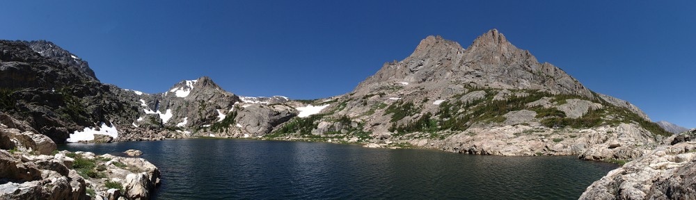
 Lost Lake, like Lawn Lake, Pear Lake, Sandbeach Lake, and others, used to be bigger. It was dammed in 1911 and reclaimed in 1985. It’s the lowest of a string of six lakes forming the headwaters of the North Fork of the Big Thompson River. Sugarloaf Mountain is a miles long wall on the north, Icefield Pass is at the western end. A side canyon runs south, ‘Little’ No Name, ‘Middle’ No Name and Gibraltar Mountain making up the western wall. Mount Dunraven is south of Lost Lake and also forms the eastern wall of the side canyon. Up this canyon are Lake Dunraven, ‘Whiskey’ Lake, and ‘Scotch’ Lake.
I might be tempted to say Lake Louise is the side canyon, as it’s much shorter. But the canyon where Lake Dunraven sits hangs about four hundred feet above Lake Louise’s outlet stream. There are a couple of unnamed ponds where the two streams find confluence. If you continue past ‘Scotch’ you end up at the foot of Rowe Glacier, a bit over 13,000′.
 I had camp set up shortly before three, nearly an hour off my estimate. No worries; that still leaves me plenty of time. The goal for the afternoon is to visit both Lake Husted and Lake Louise. The trail ends here at Lost Lake. The Foster guide says to go up the hill from the other camp but it looked easier on my side. It’s a bit marshy near the lake. The water flowing from the top of the hill makes no obvious course here; it is distributed across a wide area making the whole area spongy.
The slope is easily climbed. Near the top, continuing to follow the small stream leads to thick willow; it’s easier to pass through a narrow strip of sparse trees to the left, south. Then it’s around a rock outcropping before emerging onto gently sloping tundra. The view here is spectacular. Lake Husted is now to my right, one more hump to cross. It’s a fairly substantial lake, shaped like an open cartoon mouth: the uvula hanging from west to east. Lake Louise, which is farther up the canyon, is actually slightly downhill from here.
I spent a bit of time studying the other side of the valley, looking for the best route to Lake Dunraven. Foster suggests bushwhacking up the stream, working through thick willow. It looks to me, though, that there is a nice wide ramp a bit to the east. This will take you slightly above the lake but looks to be pretty easy. I will go that way tomorrow. I headed over to Lake Louise. I didn’t stay for long as the wind was picking up. Back at Husted I went to the end of the peninsula before retracing my footsteps back to camp.
I had dinner and listened to some music as the sun set. Here, though, it doesn’t really set. It falls behind the mountain well before sunset. We’re in shadow a long time before it gets dark. The sky is still bright and cloudless. Passing jetliners are brightly lit and look like comets. The air is so dry their contrails evaporate in a few degrees of arc.
The moon is fairly bright; no Milky Way for me tonight.
Pingback: Gorge Lakes – Preparation | Nobody is Listening