Aside from a short walk one day on my Atlanta trip back in April, I haven’t been hiking yet this year. It’s past time to rectify this.
Back in the depths of winter, I did a bit of map study and came up with a list of ten day hikes I might possibly make this year. Most of the hikes on this list are in the Indian Peaks Wilderness. One of them is Skyscraper Reservoir, which is reached via the Woodland Lake trail from the Hessie Trailhead.
Much of the lower part of the route is along the South Fork of Middle Boulder Creek. To get to the Woodland Lake trail, one must head north from this stream. On the map, there appear to be two options. The first is the trail I took last summer to reach Jasper Lake and Devils Thumb Lake. This trail runs parallel to another trail that connects the King Lake trail and the Woodland Lake trail. The two trails run on opposite sides of what I assume is Jasper Creek. The trails are never more than about a thousand feet apart, but neither trail is visible from the other. As I’ve already hiked the eastern one of these, I elected to take the western one.
This turned out to be a sound choice. There’s a spur trail connecting the two about a mile from Middle Boulder Creek. I assumed there’d be a bridge here to cross the creek. It doesn’t look like there ever was a bridge here. Many of the trails began as wagon tracks, and this crossing is simply a ford. Given the amount of snowpack the Indian Peaks received this year and the continued wet weather, the North Fork of Boulder Creek is flowing high and mighty. I’d probably be okay wading across it in August or September, but not today.
Part of the mile of trail between Middle Boulder Creek and the Woodland Lake trail can be challenging to follow. The trail gets a bit braided. It’s surprisingly easy to get off what should be the main trail onto something more like a game trail. I managed to do this hiking in both directions. It was more obvious on the way out. At one point, I knew I was on a trail I hadn’t been on earlier. I backtracked a bit but never did find where I went wrong.
Only about a quarter of a mile after the ford where the spur from the Jasper Lake trail, there’s a bridge that crosses the stream the trail is now following. To be more correct, the trail crosses the stream but the bridge is gone. Well, not “gone” so much as broken into pieces and lying in the middle of a raging torrent. It looks to me like this bridge has been out for a while, but I could be mistaken.
Again, given the flow of water, I wasn’t about to attempt a crossing. Clearly, I wouldn’t be reaching either Woodland Lake or Skyscraper Reservoir today. When I set out, I figured I might have time on the hike out to make a side trip to Lost Lake. Instead of a side trip, Lost Lake got promoted to today’s destination.
It’s only about a quarter of a mile from the main trail, up the spur to Lost Lake. The last few yards are the steepest. By the time I reached this steeper part, I’d already hiked about two and a half miles farther than anybody else here. I was powering my way up, huffing and puffing and sweating, when a downhill hiker felt the need to encourage me: “You’re already there!”
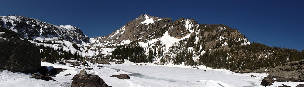
Lost Lake is a kidney-shaped body of water covering a bit less than five acres on the northern flank of Bryan Mountain, a non-descript peak topping out at less than 11,000′. There are nine campsites situated around the lake, and a trail (along with a network of social trails) circumnavigates the lake. The best view, in my opinion, is found on the eastern shore, looking a bit west of due north.
The trail guide says Lost Lake is a 2.7-mile round trip. I’m not sure if that’s the correct distance or not. If it’s measured from the trailhead, the hike is another half a mile each way. I’ve only ever seen one or two vehicles actually make it to the trailhead due to the deep water on the road that services it. Everybody else just parks along the main road. In any event, Lost Lake is the shortest hike from the Hessie trailhead and is therefore the busiest destination on the menu.
I stayed at the lake for a bit over an hour. There was a steady stream of hikers coming and going, and it looked to me like all the good shoreline resting spots were in constant use. At least a few of the folks didn’t seem to realize how well sound travels over water, and the other people there could clearly hear their conversation. I had my picnic lunch and relaxed, while other hikers fished or swam.
My first disappointment of the day was the washed-out bridge that stymied my hike to Skyscraper Reservoir. My second disappointment of the day was my peach. I should have realized it’s far too early in the season to get my favorite Palisade peaches, but when I bought them, they seemed ripe. I want my peach flesh soft, juicy, and sweet. Instead, it was crunchy like an apple; not very juicy, not terribly sweet, and only vaguely peach-flavored. So it goes.
Bridge Out!
First view of Lost Lake
Best view from Lost Lake
Lost Lake
While I ate and rested, I had my GoPro Max doing a timelapse. I should have played around with this camera before doing this. It doesn’t work at all like either of my older GoPros. With those, when I’m doing a timelapse, it snaps a still photo every two seconds (or whatever interval I want). After an hour or so, I’d have a couple of thousand stills that I can crop in whatever way I want. That allows me to make sure the image is not cockeyed, or to crop them in a way that simulates zooming or panning. Disappointment three is that the new camera outputs not a bunch of still photos, but a fully-formed 1080p video. My video editing tools allow me to do the pan/zoom/rotate thing, but I would lose quite a bit of resolution. Unless I figure out how to take a still photo every two seconds, I’ll have to continue using the older camera for time-lapse videos.
Shortly after leaving Lost Lake, the clouds started getting a bit threatening. By the time I made it back to the car, it had started to hail. The skies to the west didn’t look good at all. Perhaps it was a good thing that I couldn’t take my longer intended hike. I had my rain jacket with me, but I might very well have spent a few hours slogging through the rain.
This is the second time I’ve camped at Lost Lake. The first time was three years ago, my first backpacking trip. That time, I only camped one night so I had too little time to get past Lake Dunraven even if I’d gotten through the willow. Two nights is the way to go to get to Lake Dunraven and beyond, perhaps to Rowe Glacier.
Saturday, September 14
Gordon was my companion again. We left my place at 7:15 and arrived at the trailhead and had boots on the trail by a quarter to nine. I was surprised at the light traffic on 36. And I was pleased to see that they’ve just repaved the top of Devils Gulch Road.
I described the trail fairly well in that earlier post, so no need to repeat it here (other than to correct the obvious mistake of misidentifying Glen Haven as Drake). I will add one note, though. We stopped for a break at the same place I stopped last time. Between there and the base of the grueling, stamina sucking climb there’s a section of trees that have been toppled and uprooted. It looks much like the section of Glacier Gorge that was blown down several years ago. Here it’s a much smaller area than in Glacier Gorge.
At the Boundary Creek campsite, two hikers entered the trail ahead of us. We leapfrogged them a few times until our break at the base of the climb. I knew what was ahead and I kept telling myself that it’s more mental then physical. I’m not sure I’m convinced. I tried to focus on the trail immediately in front of me, tried not to look too far ahead. I had to take three breathers before we got to the top.
I think I mentioned that Gordon races bicycles. He’s a bit of a hill climb specialist. So here I am, after five and a half or six miles into a ten mile hike on this steep section of trail with a thirty-five pound backpack. I wasn’t going all that fast earlier, but this brought me to a crawl. My heart was going in the neighborhood of 140 and I’m breathing about as fast as I can. At our my three breaks I couldn’t help but notice Gordon isn’t breathing hard. Not even breaking a sweat.
We get to the lake in six hours, arriving twenty minutes behind the father/son duo we leapfrogged on the trail. The father was checking out the status of the north side camp sites. The prime waterfront site I had before was occupied. The father/son took one of the southern sites, we took the other northern one.
After an early dinner, we headed up to the shelf Lake Husted sits on to get a good look at what we’ll have to deal with tomorrow to reach Dunraven. We went up the way I did last trip (directly from the camp sites on the north). We came down the trail from the south side camp sites. The trail is much easier.
A marshy wetland sits at the confluence of the North Fork of the Big Thompson and the outlet stream from Lake Louise. On the maps it’s depicted as three ponds, but they are surrounded by a sea of deep, thick willow. We walked downstream a bit, looking for possible routes. It seemed if we got to a gully on the other side of a krummholz forested hillock on the other side of the stream we’d have easy going. Who knows? It could be a good passage, or it could be filled with willow. There’s one way to find out.
After our recce, we stopped at the creek to refill our water bottles. Somehow, I managed to smack my shin into a rather large rock. That really hurt! Not much blood, but it swelled up considerably. Time for a beer.
Sunday, September 15
Gordon is trying a hammock this trip instead of a tent. In the morning he reported a lack of sleep. I slept okay. It was a bit chilly, but not uncomfortably so when I had to relieve myself in the middle of the night .
We put boots on the trail at about nine. In the forest just above Lost Lake we saw a cow moose and a bull elk through the trees a few minutes apart. We quickly and easily made our way to the stream in search of a way through. Early on we had a couple of short stretches of dense krummholz but avoided the disheartening willow. Where we expected easy moving, we found easy moving. We made our way along the border of the trees and the talus field above them. Eventually we had to cut across a large willow patch, but we found a nice game trail that took us where we wanted to go.
And that was at the base of a steep, wide gully that tops out on a tundra slope about fifty or sixty feet above the northern end of Lake Dunraven. I wasn’t sure we’d be able to retrace our steps on the way out, but that was a problem for later.
A sea of willow and krummholz
Lake Dunraven sits at the mouth of a valley carved by glaciers, drained today by the North Fork of the Big Thompson river. It is the first of three lakes. The other two have no official names, but in Foster’s guide she calls them “Whiskey” and “Scotch”. Arriving at Dunraven is the hard part: the three lakes are separated by just over a half mile of tundra and a climb of less than three hundred feet.
Lake Dunraven
I was thinking we’d have plenty of time to make an attempt to reach Rowe Glacier, at the very top of the canyon at a whopping 13,120′ of elevation. There are many peaks in the park that aren’t this high. But as soon as I saw the pile of sand, scree, and talus, with a skirt of snow on the southern shore of “Scotch” I said I’d gone far enough.
‘Scotch Lake’ and Gibraltar Mountain
I said to Gordon that he could go up to Rowe and I’d wait here for him. I have no problem watching the world go by for a couple of hours. It’s a beautiful day to sit on the shores of an alpine lake with a stunning view of Gibraltar Mountain. How long could it take him? Three hours max? So he’d be back by two. No big deal.
I set my day pack and water bottle by some rocks that would serve nicely as seats. Even if I wandered off, anybody going by on the faint game trail here would see them at about eye-level. I sat there for long spells, pondering the imponderable, and occasionally made little exploration trips. Up to the top of the rise that gives a view of the valley below, or around the outlet to see if I can cross, or out on a sandy stretch to start and stop the GoPro. But mostly I sat right there.
I’d shed my thermal under clothes and had them on a rock to dry out. After three aborted attempts, a ground squirrel made his way to sniffing distance of them. He ran off right away, but he wasn’t done. He scrambled back and forth along the fringe of the willow that was growing here, stunted to only be 12-18″ high. Every now and again, he’d climb to the top of the willow for a shaky look around.
He really wanted the salt from my shirt. Twice he had licking sessions that were longer than I expected, for such a jittery creature. I’d never seen them do that, but I guess I’ve never given them the opportunity.
Sitting there, I had a bird give me a bit of a buzz. It flew from behind me, silently, until it got inches over my head and flapped loudly. I wasn’t expecting it and it made me jump. Later, I saw the same bird buzz the ground squirrel the same way.
“Scotch Lake” has one of the biggest beaches I’ve seen in the Park. The hillside on the east is quite sandy, and the big pile that made me decide to stop was pretty sandy, too. There is a fairly fresh alluvial fan below a narrow crease in the slope, severely eroded. This one has been recent enough that almost no plants are living on it, but there were other, older fans. At first I wanted to attribute this one to the 2013 floods, but it could be more recent, with one of the older ones from 2013. Who knows?
Alluvial Fan
I go back and sit by my pack and water. One o’clock passes, as does two, and three. It’s been four hours. If he only went to Rowe Glacier, he should have been back a long time ago. Perhaps he went farther? It’s only a short climb to the top and then on to the summit of Rowe Peak, or Gibraltar Mountain, or even Mummy Mountain. He may also have taken a different route down.
It also occurs to me that he might have twisted an ankle, or stepped on a “wobbler” in a talus field and cracked his noggin open. By now, even if I felt I was capable of going up toward Rowe myself it was too late. I decide I need to leave “Scotch” by five or risk darkness before I’m back to camp. So I’m working through my options if he doesn’t show up before I leave, if he doesn’t return to camp by dark, if he doesn’t show by morning, given that it’s a nearly full moon.
I tried to make a sign out of rocks on the alluvial fan. “LEFT AT 5:”. The idea is that he’d be able to see it from the top, but it was obvious that I’d made the letters too small. I left promptly at five. It took me two hours to get here, so I figured it would be about the same to return. I made it from “Scotch” to the bottom of the gully below Dunraven retracing our steps. I easily found the same game trail we used before and followed it to it’s natural conclusion, somewhat downstream of where we crossed in the morning. Here was an easy crossing using game trails. Much easier than this morning, when we whacked through some krummholz.
When I got back to the camp sites, I ran into the father/son hikers. The father asked how my hike went. I told him I was worried that I’d abandoned my companion. “You talking about the guy you hiked in with yesterday? He got back about half an hour ago.”
That turns out to be half true. He made it back to “Scotch” by about one. How he left there without seeing me or my backpack, and how he made it through without me seeing him is a puzzle. He says that when he last saw me, I looked to be leaving “Scotch”, and he figured I’d be waiting at Dunraven. So when he didn’t see me at “Scotch” he kept going. He was back to camp by two. After a while he grew concerned that I wasn’t back to camp, so he made another trip up to Dunraven. He left Dunraven the second time at five.
In the end, no harm, no foul. I didn’t really mind sitting at this lake for six hours, except for the tension of wondering if he was hurt. I probably would have enjoyed two hours at each lake, but “Scotch” has a fine view.
From the map, we expected the lake at Rowe Glacier to be a significant body of water. Gordon says it’s more like a big puddle or two. [As I’m late writing this, I’ll add a late update from him: “I’m quite sure now that I didn’t make it to Rowe Glacier, but just below it. Foiled again!”]
So it was a rather late dinner. Gordon had had a beer before I returned and had his second while I had my first. One was enough for me tonight, so there was a leftover beer.
Monday, September 16
I didn’t sleep quite as well as the night before. I was a bit restless, and although the swelling had greatly reduced, my shin was still tender.
Not long before sunrise I heard a large animal walking through camp. I figured it was either an elk or a moose. It wasn’t moving very fast, and three or four times it made an odd noise. My immediate thought was “Indigestion!” With a noise like that, I decided it had to be a moose. We discussed it in the morning over breakfast. Gordon agrees it was a moose and commented on the odd noise it made.
I drank the last beer so Gordon wouldn’t have to pack it out.
The hike out was uneventful. We took a short break at the usual place, at the bottom of the grueling climb. I had my last peach: sweet and juicy. We were making good time; I told Gordon he shouldn’t expect it to continue.
We ran into a ranger on his way up the trail. “I see you have your permit hanging off your backpack. Thanks!” He asked us where we went; Gordon showed him pictures of Rowe Glacier. His parting words were, “Have a nice hike! I have a couple llamas coming up the trail.”
Second ranger, with llamas!
Saturday, it took us six hours to make the hike up. I was expecting it to take six and a half. When we left camp on the way out, I expected to be back to the car in five and a half hours. In the end it took only five, so my actual vs estimated variance was consistent.
I thought it might be possible to bag four new lakes this trip. I fully expected to get three and have a decent shot at the fourth. I got the three. So although I didn’t bag the maximum, I didn’t come up shorter than expectations.
Which has usually been the case. It’s good to finally have a backpacking trip where I got to all the places I expected to get to. This was my fourth two night trip. Last year I thought I’d get to four lakes on the Gorge Lakes hike. I got one. My July trip was way too early to get either of the two high lakes above Bluebird. So early that I didn’t even make it as far as Bluebird. And two weeks ago when I reached one of four again in Spruce Canyon.
It was unfortunate that Gordon missed me on his hike down from the glacier. I didn’t really mind spending six hours there. But I did feel pinned to a spot. Six hours is a long time, and would have been more enjoyable if it had been two hours at each lake. But the GoPro battery held out a surprisingly long time. I ran the camera with five different views for a total of nearly two hours. I never get two hours of battery at the track.
It’s unlikely I’ll be back there. This was my second trip. It’s a long hike to camp. I much prefer the six to seven mile range to ten. Luckily, that isn’t much of a limitation in the Park. There are still many lakes I haven’t visited that are within reach from a campsite six or seven miles in.
I’m happy that we got through the sea of willow and krummholz as easily as we did. I obsessed for days over a photo I took last time that shows the area. Our recce Saturday evening was time well spent. All that miserable vegetation wasn’t nearly the roadblock I feared it could be.
I’m pleasantly surprised that I was able to average two miles an hour on the hike out.
I got almost twice the normal amount of time lapse footage. I didn’t use it all, but probably too much.
I was awoken from a deep sleep by the wind. A gust came down on the tent, hitting it like a drum: boom! It was 12:30. The wind certainly didn’t die down at sunset. Listening to music, waiting for the stars to appear, I found a rock someone had placed next to a tree. It made a nice seat. Leaning up against the tree resulted in a rocking motion, the tree swaying considerably in the wind. The wind had mellowed a bit by the time I climbed into the tent but now there was nothing mellow about it.
From 12:30 to 6:30 I didn’t get much sleep. The tent only drummed once more but the wind gusted and raged the rest of the night. At 6:30 I heard an odd noise. Sounded like a snort. At first I thought it was an odd noise for the tent to make in the wind. But it sure sounded like a snort. A few minutes later I heard a couple more snorts, farther away now. Elk, perhaps? I didn’t hurry and by the time I got out of the tent there were no critters in sight.
I had breakfast and took down the tent and packed everything but the bear vault into the pack. When I was done I stepped through the trees to the lake and met one of the guys in the big group. Yesterday, four or five of them went up the canyon all the way to Rowe Glacier, then summitted Mount Dunraven. Sounds like a great day to me. I told him I wanted to go as far as Scotch. He recommended taking the ramp I spotted yesterday.
While we’re talking he points to the marshy area I crossed to climb the hill. “There’s a moose.” He went off to get his long lens. I grabbed some water and started off the way I went yesterday. The moose had disappeared now, but I was heading that way so I kept on the lookout for him. Never did spot him again.
I retraced yesterdays route to the tundra slope south of Husted. The wind hadn’t died down much. At sunrise the sky was clear but as the morning progressed a wave cloud formed just to the east, putting the area in shadow.
I needed to get to the other side of the valley and it wasn’t clear to me which way to go. It’s a wet marshy area with a couple of ponds, lots of willow, lots of flowing water. I started working my way across, got in an area of long grass. Near a wildlife trail the grass was matted where a couple of elk may have bedded down.
In a particularly spongy area I had stopped and was looking for a good way to go. I saw some movement on the ground out of the corner of my eye. I wouldn’t have seen it if it had just stayed still but it took another hop away and I saw it. The frog was three or four inches long, matched the color of the muck pretty well. He was gone in a few seconds. First frog I’ve ever seen in the Park.
Ultimately I got stymied in here. I tried a couple of different routes with no luck. The clouds were getting bigger, the wind wasn’t getting better, I decided to abort. There’s obviously a way across, I just need to take another look at it. This is a pretty cool place and I have an excuse to come back again. So it goes.
I headed back toward Husted. I decided to go circumnavigate it. The southern shore of the lake is mostly tundra. The peninsula is big rock slabs. The northern shore is more talus. Standing at the outlet you have a nice view of Gibraltar, ‘Middle No Name’, and ‘Little No Name’.
I made two round trips up the slope between Husted and Lost. I passed a jawbone all four times. About eighty feet downhill and across the stream from it is an antler fragment, two points off a bigger rack. Likely the same animal.
I was back to the camp by 9:30 and on the trail by 9:36. I immediately ran into another one of the guys from the other camp. He was off to look for Lost Falls. I’m pretty sure there’s a camp site there, but I believe it’s closed. I didn’t see any signs for the falls or the site and neither did he.
We chatted a bit as we walked. He told me they were “llama supported.” They hired an outfitter out of Estes who packed their gear in by llama and will return to fetch it tomorrow. They’re all carrying their day hiking gear instead of big backpacks. They hiked all the lakes and a few of the summits. And perhaps find Lost Falls. I wished him a good day and at that he was off, running.
A few minutes later I caught up to four more from that group. Two couples, one of each who had to work tomorrow so they’re on their way out. The first guy I met was here. I last saw him as he ran off to get his telephoto lens. He asked, “Did you see that moose move through your camp?” It was there when he got back with his lens. I was on my way up the hill by then. So this would be the second time a moose was in my camp and I didn’t see him. It was a moose that snorted outside my tent, not an elk.
We passed each other a few times as the day wore on. Next I met two young women headed to the lake. I gave them the scouting report and my map. After exiting the Park I started seeing more people. I was too early yesterday to see the day trippers, but they were in peak rush today.
Before now I haven’t given llamas much thought. There’s that sign on the campground shortcut to Thunder Lake: “No Livestock – Llamas excepted”. Llamas can carry something like eighty pounds. That means probably three llamas did a round trip on this trail Friday. Llamas are pretty low-impact pack animals. I saw absolutely no sign of the llamas except for one thing. I’ve been seeing llama shit on trails for years and never realized what it was.
I’m a hiker, not a backpacker. I’m working on changing that. On my Laguna Seca trip I spent five nights camping to see if I could deal with sleeping on the ground. I passed that test. Now it’s time to carry all my gear up a trail. A few weeks ago I made the rounds and borrowed a tent from John and a backpack from Jerry. I made my reservations that night. I snagged a spot at Lost Lake, 9.7 miles up the North Fork trail from the Dunraven trailhead.
I suppose I was under-prepared for the trip. I only assembled the tent once. I did one test pack of the backpack. I fiddled around with the backpack a bit but was never happy with the fit. But I get points for not forgetting to take everything I needed. When I did my first test pack (no food or water) the pack weighed in at 20.5 pounds. Final pack was 31 pounds but I tossed in the iPod and headphones before locking the car.
Denver’s forecast for the weekend was low-80’s on Saturday, upper-80’s Sunday, clear and dry. I figured it would be different at 10,700′ and was anticipating clear skies, high winds, and near freezing temps by morning. My sleeping bag is quite old and I don’t know how well it handles the cold so I made sure to have plenty of layers.
I’ve never hiked in this part of the Park. The trailhead is in the Comanche Peaks Wilderness of the Roosevelt National Forest, a few miles from Drake. Drake was more or less erased by the floods three years and a day ago. I haven’t been through here since then. The road is better than ever, billiard table smooth. The dirt road to the trailhead is very good also.
As I said, the trail starts in NFS land. The first section of the trail drops down a gully to the river. The flood damage here doesn’t seem so bad, three years later. It’s obvious how big the river was at full flow – there is nothing but rocks and sand for several feet on each side of the river. Weeds haven’t even taken over. I saw only two man-made pieces of debris. The trail was washed out in a few places and has been moved or rebuilt robustly.
After a short stroll along the riverbank the trail crosses private property – Camp Cheley. Stables, corrals, a rodeo ground. Just before returning to NFS land there are concrete bridge abutments without a bridge. Not long after leaving Camp Cheley we leave the riverbank and work our way upslope. By the time we return to the river there is no sign that any flood occurred.
Most of the hike offers nothing to look at. The trail goes through mixed forest and has no outstanding views. No views at all, really, until nearly at your destination. Although the trail climbs steadily, I was feeling pretty good that I hadn’t come across one of those four hundred foot climbs in a kilometer. I didn’t get on the trail until a bit after eight and wasn’t keeping my usual pace. I hoped to have camp set up by two and figured to picnic well before getting that far.
There’s a campsite called Halfway. I had assumed the obvious, that it’s half way from the trailhead to the lake, a little over five miles. This is incorrect. It’s not half the distance, it’s half the climb. It’s closer to six miles. So from here to the lake will be, on average, about half again as steep as we’ve been doing.
Not far past Halfway the trail returns to the stream. I found a pleasant spot for a break. I was happy to shed the backpack for an extended time. I had been taking more breaks than normal, but all quite short. It felt good to take an extended rest. As it turns out, I took my break right at the bottom of a long, steep (by pack trail standards) section. It wasn’t quite as steep as four hundred feet in a kilometer, but it was more like two kilometers than one. And the trail, although well maintained, is more like the campground shortcut to Thunder Lake than the trail to Nokoni – no shortage of roots and rocks to step over. On this stretch my legs really felt the thirty extra pounds.
I’m going to Lost Lake, but everything in the area is Lost. There’s also Lost Falls. I didn’t find Lost Falls, but I wasn’t really trying. There’s a campsite called Happily Lost. And after the steep section of trail, after the trail crosses a rock outcropping and gives us our first view, the sight of miles of forested valley below us, behind us, we arrive at Lost Meadows. Now we finally catch a glimpse of the mountains ahead. Just a glimpse – the bare hulk of Mount Dunraven.
By now I’ve been hiking five and a half hours. I’ve run in to six people. At the trailhead there were only a few cars; all still had dew on them so I was the first arrival of the morning. As I was stepping onto the trail, a truck pulling a horse trailer arrived. It was two women riders, who passed me just after Camp Cheley. I asked them how far they were going. They said they didn’t know: as far as they could go. They were happy to see the trail finally open.
I met the occupants of both the Lower Lost Lake sites on their way out. First was two guys, my age, perhaps a few years older. They told me the Upper Lost Lake sites were taken by a big group (“They had llamas. A big Coleman stove, everything but the kitchen sink”). Of the two Lower sites they felt they had the best one, #1. The next couple, French accents, had stayed at #2. They said the wind wasn’t that bad, that it had mostly died down after sunset.
When I got to the lake I went to the Upper sites to see if the big group was still there. They were, although nobody was home. Two large tents were erected on one site and the Coleman stove sat on a table in the other. Their bear canister was off the trail below the camp. Their setup struck me as a pretty good one: a bedroom and a kitchen. No sign of any llamas, though.
On my side of the lake I headed to site #1 and dropped the pack there. Then I walked back to #2 to check it out. I preferred #1 as it had a view of the lake. This was probably not the best choice. The other site was farther back in the trees; I only had a few trees between me and open water.
Lost Lake, like Lawn Lake, Pear Lake, Sandbeach Lake, and others, used to be bigger. It was dammed in 1911 and reclaimed in 1985. It’s the lowest of a string of six lakes forming the headwaters of the North Fork of the Big Thompson River. Sugarloaf Mountain is a miles long wall on the north, Icefield Pass is at the western end. A side canyon runs south, ‘Little’ No Name, ‘Middle’ No Name and Gibraltar Mountain making up the western wall. Mount Dunraven is south of Lost Lake and also forms the eastern wall of the side canyon. Up this canyon are Lake Dunraven, ‘Whiskey’ Lake, and ‘Scotch’ Lake.
I might be tempted to say Lake Louise is the side canyon, as it’s much shorter. But the canyon where Lake Dunraven sits hangs about four hundred feet above Lake Louise’s outlet stream. There are a couple of unnamed ponds where the two streams find confluence. If you continue past ‘Scotch’ you end up at the foot of Rowe Glacier, a bit over 13,000′.
I had camp set up shortly before three, nearly an hour off my estimate. No worries; that still leaves me plenty of time. The goal for the afternoon is to visit both Lake Husted and Lake Louise. The trail ends here at Lost Lake. The Foster guide says to go up the hill from the other camp but it looked easier on my side. It’s a bit marshy near the lake. The water flowing from the top of the hill makes no obvious course here; it is distributed across a wide area making the whole area spongy.
The slope is easily climbed. Near the top, continuing to follow the small stream leads to thick willow; it’s easier to pass through a narrow strip of sparse trees to the left, south. Then it’s around a rock outcropping before emerging onto gently sloping tundra. The view here is spectacular. Lake Husted is now to my right, one more hump to cross. It’s a fairly substantial lake, shaped like an open cartoon mouth: the uvula hanging from west to east. Lake Louise, which is farther up the canyon, is actually slightly downhill from here.
I spent a bit of time studying the other side of the valley, looking for the best route to Lake Dunraven. Foster suggests bushwhacking up the stream, working through thick willow. It looks to me, though, that there is a nice wide ramp a bit to the east. This will take you slightly above the lake but looks to be pretty easy. I will go that way tomorrow. I headed over to Lake Louise. I didn’t stay for long as the wind was picking up. Back at Husted I went to the end of the peninsula before retracing my footsteps back to camp.
I had dinner and listened to some music as the sun set. Here, though, it doesn’t really set. It falls behind the mountain well before sunset. We’re in shadow a long time before it gets dark. The sky is still bright and cloudless. Passing jetliners are brightly lit and look like comets. The air is so dry their contrails evaporate in a few degrees of arc.
The moon is fairly bright; no Milky Way for me tonight.