Round Pond

Round Pond is a small round pond that lies on the saddle between Joe Mills Mountain and Mount Wuh. According to the map, it has neither inlet nor outlet streams. I happened across it when thinking of going to the two small, unnamed ponds 350′ above and about four tenths of a mile southwest of Lake Helene.

Not far away from Round Pond is another small body of water called Marigold Lake. (This should not be confused with Marigold Pond, also in the vicinity, a few yards down the outlet stream of Two Rivers Lake.) After studying the map for a while, it seemed to me that it should be possible to visit both these lakes on the same hike.

The Foster guide has the distance to Round Pond at 2.4 miles. The distance from Round Pond to Marigold Lake looks to be about a kilometer. Assuming I make it to Marigold Lake, I’d return to Bear Lake on Foster’s route which she has at 3.9 miles. So the whole thing is about 6.9 miles and less than 900 vertical feet. Should be relatively easy, yes?

Well, perhaps not. Both lakes are quite small and in the middle of the forest. With unobstructed views of Joe Mills Mountain and Mount Wuh it would be easy to locate Round Pond, but I fully expect the forest to be dense enough to provide no views of either of those mountains. And it may be challenging to get from Round Pond to Marigold Lake by my route, having to traverse some fairly steep terrain between them.

And, who knows? If I get back to Lake Helene early enough, maybe I can get to those two unnamed ponds that caught my eye in the first place.

Saturday, July 20

I arrived at the Park & Ride at about ten minutes after eight. I’ve never seen that parking lot so full. There were only a few spots left, and the line for the shuttle wound back and forth several times. I didn’t make it to the Bear Lake parking lot until a few minutes before nine. No big deal, this hike shouldn’t take too long.

The only snow on the trail was the large drift where the trees thin out on the east side of Flattop. In the winter, when I go to either Helene or Two Rivers Lakes, this is where I always lose the trail. The wind blows all the time here in the winter, quickly erasing hikers’ tracks. But in mid-July it’s just a hundred yards or so of snow and not any sort of navigational impediment. The trail both before and after this snow is filled with the overflow of the rivulets that cross it.

Farther up the trail is another spot that gives me grief in winter. The trail crosses a talus field and in winter I’ve often resorted to going to the bottom of the hill to avoid the traverse. It’s steep enough here to give me pause, and better safe than sorry. Again, in mid-July this is not a problem, but this talus field is where I leave the trail in my quest for Round Pond.

Round Pond lies on the saddle somewhere in the center of this photo.

Immediately after stepping across Mill Creek I’m in fairly dense forest. A few minutes later an elk crashed across my path just a few yards in front of me. This was fortuitous, as it led me to a game trail. It’s not too difficult to cover ground but as I suspected, navigation is a challenge. It’s quite flat and level and no landmarks of any kind are visible. My game trail started to veer to the right when I thought I should be veering to the left, so I abandoned it and started making my own way.

On my cell phone I have a speedometer app that I use in the car. The car’s speedometer is not at all accurate, and in addition to the correct speed, it also displays (among other things) your elevation and direction of travel. It’s not a compass: to get a direction you have to be moving. This app works even when the phone is in airplane mode, so I often use it when I’m off-trail and need to make my way to a particular elevation.

Before long I figured I was in the right place and should be coming across Round Pond any minute now. But it’s really hard to judge, so I started doing a bit of a random walk across this saddle. It had been about an hour since leaving the trail and I hadn’t found it yet. I was just about to give up when I spotted a gap in the trees: there’s my lake. The trees are well back from the water, separated by, essentially, a giant sponge. Walking across it, my boots weren’t getting wet, but each footstep sank a few inches.

Round Pond

There were no rocks or fallen tree trunks to sit on, so I didn’t stay long. Not much to look at, either. Just a few Elephant Head flowers here and there. My options were to try to retrace my route and return the way I came, or to head for Marigold Lake. I knew I might have a hard time finding that lake, but given all my changes in direction to this point, I figured turning back wouldn’t be an easy proposition either. So onward it was.

After leaving Round Pond, the terrain remained flat and level, but the amount of deadfall was much increased. It was like navigating a maze. A short distance later the slope started to fall in front of me. Now the deadfall wasn’t so much a maze as a series of hurdles: almost all the trunks were lying perpendicular to the path of somebody attempting to traverse the slope. Between the steepness of the slope and all the deadfall, my progress had slowed considerably. I had to consider each foot step.

If I could keep my current elevation and contour around the mountain, I’d be a bit above the lake and it would be fairly easy to spot. The slope kept getting steeper and steeper until I was a bit out of my comfort zone. I’m okay traversing this sort of slope in the forest, but I really didn’t want to ascend or descend. And I figured there was a good chance I’d come across some large rock outcropping that would prevent me from traversing.

Sure enough, that’s what happened. I only came across one of these outcroppings, but it was enough. I couldn’t find a way over the top so I had to descend forty or fifty feet. By now I was getting a bit disheartened. This was taking much longer than I had anticipated. I still hadn’t had lunch as I hadn’t found a suitable place: a rock or log to sit on, with some sort of view and a bit of a level area to set my things. And I see I have neglected to mention the rich insect life of the forest covering Joe Mills Mountain.

Just as the steepness of the slope began to diminish, I came across a talus field. It had a number of flat rocks, sitting in the sun, with a view to the north and west. I rested here for about half an hour and had my lunch. It was now about 12:30, an hour and a half since leaving Round Pond. And I guessed that I hadn’t covered a kilometer yet, meaning I was covering less than four tenths of a mile per hour. That’s pretty slow.

Between Round Pond and my lunch spot, I caught only a few glimpses of the surrounding area. Once or twice I had partial views of Fern Lake and Odessa Lake below me, and the Fern Lake Fire scar on the slopes of Tombstone Ridge to the north. Only upon entering this little talus field did I begin to see Gabletop, Little Matterhorn, and Notchtop.

Having had my little picnic lunch, I resumed my traverse. My elevation was still a bit lower than Marigold Lake but there had been no sign of any sort of bench above me where a small lake could reside. But just a few yards after my talus field, I could spot some blue sky between the trees above me. Perhaps I was right below the lake!

I climbed a few yards but was stymied three or four times by dense vegetation. I couldn’t get through so I continued along the slope. After a short distance I could finally get onto the bench above me. But no lake was here. Dang.

To my south stretched an open expanse, mostly talus with some grassy/rocky ramps giving nice views of upper Fern Creek canyon. Heading mostly south, I soon saw the trail to Odessa Lake. It was now time for my final decision of the day. Should I go up the trail towards Lake Helene and back to Bear Lake, or down to the Fern Lake trailhead? It took me so long to get here that I didn’t have time to make my side trip up to those ponds above Helene but I headed back to Bear Lake anyway.

Upper Fern Creek Canyon

I passed the nearest point to Lake Helene at 2:30, stopped to refill my water when I crossed Mill Creek below Two Rivers Lake, and enjoyed the easy downhill slope all the way back to Bear Lake. There was no line for the bus and I was back to the Park & Ride at 4:20. This little excursion took quite a bit longer than I anticipated. The section between Round Pond and my picnic spot on the slopes of Joe Mills Mountain put me a bit outside my comfort zone but on the whole, the day wasn’t particularly strenuous.

Squirrel noshing on a mushroom cap

I can’t particularly recommend a visit to Round Pond, unless you’re looking for a navigational challenge. It would have been nice to visit Marigold Lake, but now that I’ve been in the neighborhood I think I can make it another time easily enough. Looking at aerial photos of the area, my little picnic spot was within 20 or 30 meters of it! If I’d have climbed slightly north from my spot instead of slightly south, I’m certain I’d have found it. So Marigold Lake is on the “to-do” list, but directly from the Odessa Lake trail across the open terrain of talus and grassy ramps.

Mid-Ohio Trip – Chicago

Day 7 – Friday, May 31

The weather guy on TV said the sky today would be “milky”. That’s not a description I recall hearing before. Turned out to be fairly apt.

When picking a hotel for my stay in Chicago my first consideration was to be roughly half way between downtown and Autobahn. That meant a western suburb. Next consideration was proximity to a train station. Without knowing anything about Chicago mass transit I had to ask around. Bob suggested the best way to go was on the Metra. This is an entirely different train system than the “L” operated by the Chicago Transit Authority. With this in mind, I picked a hotel just a few miles from the Naperville Metra station.

I didn’t want to have to get to the station early enough to find a parking spot, so I grabbed a Lyft. At the station, I was expecting to buy tickets from a machine. That’s how it works for the BART in San Francisco and the Metro in D.C. It works differently for Denver’s train system, at least the one I’ve ridden. There are no turnstiles but you still get your ticket from a machine. At the Metra station, you actually go to a ticket window and buy from a person. How quaint.

The train cars are tall double-decker affairs. The lower level is two seats on each side of the aisle. The upper level is one seat each side, with some seats facing forward and others that are jump seats that fold down, and you face the aisle. Up there, you’re on one side or the other as there’s no floor in the center. A conductor comes through and checks tickets, and from the lower level he can collect from the folks above.

The train deposits you in Union Station. The trains are below ground level and there are many platforms. Not knowing where to go I just let myself be carried along by the crowd, turning right and left, going up escalators, I finally was deposited on Adams St on the bank of the Chicago River. The general plan was to wander the public spaces by the Lake, then spend some time at the art museum and go to the observation deck at either the Willis Tower or the Hancock Tower. I could either find dinner downtown or head back to Naperville.

So finding myself on Adams St at the river was a good starting place. All I needed to do was walk a few blocks east and I’d be at the museum. It wouldn’t open for a while, so I’d have time to wander through the parks and gawp at the skyline.

Bean There, Done That

I didn’t have a clear sense of how the place is laid out, so I just started at the northwest corner and went around clockwise. This meant I’d start in Millennium Park. The big attraction here is “the bean,” which is actually called Cloud Gate. When I arrived there were only a few people. Great luck, I thought. I can get some pictures without a huge crowd. I managed to take one or two photos before a busload of kids showed up. Ah, well, so it goes.

A few yards south of Cloud Gate is the Crown Fountain. I don’t think I’d heard of this before. I’m pretty sure I’d remember it. There are two sort of obelisks that face each other with water cascading down the sides. And I literally mean “face each other.” They have human faces on them. The faces are animated. That is, they slowly change their expressions. Periodically, they purse their lips and streams of water pour from their “mouths”.

Heading toward the lake you come across the Jay Pritzker Pavilion, an interesting open-air venue, obviously designed by Frank Gehry. From there you can take a pedestrian bridge across Columbus Drive to Maggie Daley Park. It has all sorts of little nooks and crannies for kids to explore: forts and pirate ships, hall-of-mirrors gardens, sculptures, and so on. Heading south along Lake Shore Drive eventually takes you to Buckingham Fountain.

From here I crossed Lake Shore Drive and walked along the water’s edge. To the north you can see Navy Pier, to the south the planetarium, aquarium, and the Field Museum. Heading back west takes you through the south end of Grant Park. Before you get to Michigan Avenue you’ll find the loop’s railroad tracks below grade, out of sight. I skipped some of these little parks and worked my way back to the art museum, the Art Institute of Chicago.

It’s a big museum. I didn’t make it through the entire place, but I got close. I’m not the biggest art fan. That is, I like art, but there are some types that don’t appeal to me. So I was perfectly willing to skip various exhibits. As it turned out, I don’t think I skipped much. I’m not an expert on art or art museums by any stretch of the imagination, but I’d suggest that this is one of the top art museums in the world. Perhaps not “top ten” material, but not far from it. I was surprised how many of the works I recognized, and how many works by artists I recognized.

American Gothic on the left and Nighthawks through the doorway on the right

Among the exhibits that didn’t appeal to me are some of the works of modern art. This would include Jackson Pollack, who I suspect just sold his drop cloths. Another one was just a set of colored panels: a block of blue next to a block of red next to a block of green next to a block of white, or things to that effect. I don’t understand this stuff. Picasso may not be my cup of tea, but some effort obviously went into it. It’s a different view of reality, but there’s a viewpoint there, even if it doesn’t speak to me. A series of paint swatches seems like they’re just trying to pull one over on me.

The rest of the exhibits are amazing in one way or another. The miniature rooms were incredible. A woman did a series of rooms either based on real houses or her imagination that represented a place and time. Furnishings, art, lighting, rugs, views into adjoining rooms. I almost skipped that one and I’m glad I didn’t. I really liked the impressionists, too. The American art included quite a lot of furniture. “They don’t make them like that anymore” is an understatement. The level of craftsmanship is insane. The several rooms with armor and arms was great, too.

I did get a bit of a kick out of all the people taking pictures of the art. I’ve done this on occasion myself, to be honest. But these days I’m more interested in the room as a whole, or the people looking at the art. Because I can go on-line and find a much better picture than I can take of that Picasso.

The admission ticket that I bought for the art museum included a trip up to the Skydeck attraction at the Willis Tower. That’s the observation deck on the 103rd floor. I entered the building through the wrong entrance. A doorman there immediately asked if I was looking for the Skydeck. I jokingly asked him if he thought I looked like a tourist (because I obviously did: Hawaiian shirt, shorts, and a camera around my neck).

Other than the views, the attraction is The Ledge. They basically took out four windows and made bay windows with transparent floors. Groups of three or fewer people get sixty seconds, four or more get ninety. Everybody does it, so the line is long: maybe 20 minutes. I got to chatting with a group there where one of the guys wanted to do a handstand. He said he’s been doing handstands all over Chicago. Here, he was reluctant because he’s afraid of heights. I said, “Hey, don’t worry: nobody has fallen out the entire time I’ve been waiting here!”

I have a problem with heights, but this didn’t bother me

By now I was done. I’d been walking all day and I was looking forward to sitting down on the train. I managed to find the correct train without looking too much like a rube. I sat on the upper level this time, thinking there might be a view. There wasn’t. After some time, my phone rang. It was Bob. After chatting for a couple minutes I couldn’t help but notice that several people were giving me the evil eye for talking on my phone. I told Bob I’d call him back. Once off the train, I got the phone out and started to call a Lyft. As soon as it asked where I wanted to go, it told me I was down to 3% charge and shut itself off. (I left the hotel with a fully charged phone. Most days, it’s down to 55-60% by the end of the day. Some days it gets happy and goes through 90% by bed time. This day, it must have been positively ecstatic, to use 100% in 10 hours. And I hardly even used it.)

That’s just great. Not only can’t I call a car, I can’t even bring up a map to tell me which way to hoof it. I didn’t even really know how far it was. I was hoping it was closer to four miles than seven. On the way to the station I didn’t really pay attention to where we were going, but I did have a general direction. So off I went, expecting that I’d be able to stop at any number of places to ask for directions. I passed a Little Caesar’s Pizza place and a DQ. I considered going to the pizza place and ordering a pizza for delivery to my hotel, then catching a ride with the driver. But the line was out the door, as was the line at DQ. After that, I was in a residential area whose few businesses were all closed.

There were no other pedestrians and when a hippyish bicyclist came by I stopped him to ask directions. He told me I was going in the right way and that if I got to the highway I’d gone too far. I found the street I was looking for and soon found my hotel. The last hurdle to jump was the lack of a crosswalk across a multi-lane road with a high speed limit. As you may have guessed, I managed to cross without getting run over. Back in my room, I plugged in to recharge. I checked how far it was: less than three miles.

I had dinner at a brew pub next to the hotel and had a large beer.

More photos here.

Today’s miles: 0 road Total miles: 1,729 road, 407 track

GABF

Thursday, October 6

I’d been to the Great American Beer Festival before. That was at least twenty years ago. We bought tickets at the door. The tasting glass was actually glass. You could get as many samples of beer, one ounce at a time, as long as you had the glass. Sometimes people dropped the glasses – the sound of the breaking glass had a ringing quality that allowed it to be heard over the general hubbub of the crowd. People at the epicenter would call out an “Oooooh!” that rippled through the hall. No more beer for some poor guy. This occurred with increasing frequency as the night progressed, as you might imagine.

All they had was beer; there was no food. This was back in Currigan Hall. It was just a big open space (the world’s largest rigid space frame when it was built in 1969). There was a balcony that went all the way around the inside, just a wide corridor, really. Nowhere to sit, but you could lean on the railing take in the spectacle of the next dropped tasting glass. We found a vending machine up there, Funyuns and other long shelf life pseudo-food.

That was then. Things are different now. I haven’t even tried to get tickets as they sell out so fast. This year I’m told it took sixty-seven minutes. Sixty thousand people will taste nearly seventy-five hundred different beers. It’s the largest beer festival in the country, attended by people from all over the world.

Jason was kind enough to give me a ticket this year.

I don’t make it downtown very often. Last time was for the Bronco’s parade back in February. Genae and I took the bus, the Flatiron Flyer, to Union Station. That probably would have been the easiest thing to do tonight but Genae suggested I make an adventure of it and take the train instead. We have a few free passes, so what the heck.

After an early dinner I headed to the train station. I didn’t know exactly where it is, so I just punched the address into the phone and set off. Naturally, it took me to where they’re still building another parking lot, on the wrong side of the tracks from where I needed to be. Finally in the garage, I get a prime end spot next to the stairs. As I’m stepping out of the garage, I hear a train whistle. There’s the train, pulling into the station. Several minutes earlier than I expect. On reflection, it must have been sitting there the whole time as this station is at the end of the track (for now). It wasn’t pulling into the station from the east, full of commuters, it was coming from the west, empty.

I didn’t exactly run to the train, but I did pick up my pace a bit when a fellow ran past me. I needed to validate my free ticket. The guy who ran by me was working one of the credit card machines. I looked at the other but didn’t see anything about validation. I asked the other guy if he knew how to validate my pass but he didn’t. We got on the train, sat across the aisle from each other. How much trouble could I get into for not having my pass validated?

It’s a nice car, brand new. We sat a while before the doors closed and we departed. I never went through a turnstile so I assumed somebody would come by to check for tickets. I chatted with my fellow passenger. He, too, was headed to the festival. He’d spend the evening there with his son, then Uber home to Erie. Before long our conductor arrived. I told him I failed to validate my pass. He told me what I should look for next time and took my pass, which he immediately gave back to me.

When we got off the train we immediately met two women who asked us if we knew how to get to the beer fest. “We think we know where we’re going. You’re welcome to come with us.” On the train he had asked me where we needed to go. I said I thought it was 14th and Champa. We’d hop on the mall shuttle and head that way. Of course, half the people on the shuttle were going to GABF. Turns out I was off by a couple of blocks. The entrance is on 14th at California.

There was a line of people, four abreast, going through the glass doors. My train companion headed to will call and I went to get in line. At first I thought it was maybe fifty feet long. But it took a jog around a corner. Then underneath the building, past service entrances, along the single row of parking, almost to 12th Street. How many people in a line two and a half blocks long and four across? And the place has been open for about an hour, so how many people were there already?

Mercifully, the line moved pretty quickly. As we made our way toward the front a steady stream of people passed us on their way to the end. Lots of guys had necklaces made of pretzels. Take a bite of pretzel between samples to clear the palate. Judging by the number of pretzels, some of these guys were serious. Some were not so much necklaces as bandoliers, reaching from left shoulder to right waist.

Once inside I headed over to say hi to Jason. His team was pouring last year’s medal winners in the back corner of the entrance hall. I had my first sample right next door, the Bleidorf Kolsch from Periodic Brewing.

I downloaded the GABF app a few days ago but haven’t played around with it. I was thinking I’d be able to check off the beers I’d sampled. Instead, it gave me all sorts of sliders. I’d have been happy with a checkbox or a 1-5 star rating. It also wanted me to sign on to Facebook. Too much bother. Instead, I grabbed a pen from Port City Brewing and circled all the beers I tried in the 32 page beer list we got at the door.

My plan, more or less, was to stick to lighter beers for the most part, avoid standing in line, skip Colorado brewers and anything I can buy at the store, and walk every mile of the show. I also wanted to keep in mind the train schedule; my choices were 9:21 and 10:21.

I’m a lightweight. I sampled only a fraction of a percent of the available beers. I tried a variety of fruit beers: watermelon, black cherry, blueberry, peach. I like my fruit beer to be subtle. These were all pretty “in your face” except the blueberry. The only dark beer I tried was a chocolate chipotle – the chocolate was just undertones and the chipotle a smoldering aftertaste.

By the time I’d made a couple laps of the place I decided I’d had enough and made my way out. I arrived at 16th Street about sixty seconds too late to grab the shuttle. I expected to see another one soon; I expected one to pass me before I walked the length of the mall. This was optimistic: I never saw another shuttle. I made it to the train station at 9:24, missing the train by three minutes.

My free pass also works for the bus. When I texted Genae to tell her I’d be waiting nearly an hour for the train she suggested I take the Flatiron Flyer and she’d pick me up and shuttle me to the train station to fetch my car. Seemed like a lot of bother, and it kept her up after her bedtime, but in the end it saved me ten or fifteen minutes. And saved me pacing up and down the platform for an hour as I didn’t see any benches.

I enjoyed the evening. The beer festival isn’t something I need to do every year but it was fun and interesting.

Beyond Lost, Day 2

Sunday, September 11

I was awoken from a deep sleep by the wind. A gust came down on the tent, hitting it like a drum: boom! It was 12:30. The wind certainly didn’t die down at sunset. Listening to music, waiting for the stars to appear, I found a rock someone had placed next to a tree. It made a nice seat. Leaning up against the tree resulted in a rocking motion, the tree swaying considerably in the wind. The wind had mellowed a bit by the time I climbed into the tent but now there was nothing mellow about it.

From 12:30 to 6:30 I didn’t get much sleep. The tent only drummed once more but the wind gusted and raged the rest of the night. At 6:30 I heard an odd noise. Sounded like a snort. At first I thought it was an odd noise for the tent to make in the wind. But it sure sounded like a snort. A few minutes later I heard a couple more snorts, farther away now. Elk, perhaps? I didn’t hurry and by the time I got out of the tent there were no critters in sight.

I had breakfast and took down the tent and packed everything but the bear vault into the pack. When I was done I stepped through the trees to the lake and met one of the guys in the big group. Yesterday, four or five of them went up the canyon all the way to Rowe Glacier, then summitted Mount Dunraven. Sounds like a great day to me. I told him I wanted to go as far as Scotch. He recommended taking the ramp I spotted yesterday.

While we’re talking he points to the marshy area I crossed to climb the hill. “There’s a moose.” He went off to get his long lens. I grabbed some water and started off the way I went yesterday. The moose had disappeared now, but I was heading that way so I kept on the lookout for him. Never did spot him again.

I retraced yesterdays route to the tundra slope south of Husted. The wind hadn’t died down much. At sunrise the sky was clear but as the morning progressed a wave cloud formed just to the east, putting the area in shadow.

I needed to get to the other side of the valley and it wasn’t clear to me which way to go. It’s a wet marshy area with a couple of ponds, lots of willow, lots of flowing water. I started working my way across, got in an area of long grass. Near a wildlife trail the grass was matted where a couple of elk may have bedded down.

In a particularly spongy area I had stopped and was looking for a good way to go. I saw some movement on the ground out of the corner of my eye. I wouldn’t have seen it if it had just stayed still but it took another hop away and I saw it. The frog was three or four inches long, matched the color of the muck pretty well. He was gone in a few seconds. First frog I’ve ever seen in the Park.

Ultimately I got stymied in here. I tried a couple of different routes with no luck. The clouds were getting bigger, the wind wasn’t getting better, I decided to abort. There’s obviously a way across, I just need to take another look at it. This is a pretty cool place and I have an excuse to come back again. So it goes.

I headed back toward Husted. I decided to go circumnavigate it. The southern shore of the lake is mostly tundra. The peninsula is big rock slabs. The northern shore is more talus. Standing at the outlet you have a nice view of Gibraltar, ‘Middle No Name’, and ‘Little No Name’.

I made two round trips up the slope between Husted and Lost. I passed a jawbone all four times. About eighty feet downhill and across the stream from it is an antler fragment, two points off a bigger rack. Likely the same animal.

2016-09-10-15-09-54sI was back to the camp by 9:30 and on the trail by 9:36. I immediately ran into another one of the guys from the other camp. He was off to look for Lost Falls. I’m pretty sure there’s a camp site there, but I believe it’s closed. I didn’t see any signs for the falls or the site and neither did he.

We chatted a bit as we walked. He told me they were “llama supported.” They hired an outfitter out of Estes who packed their gear in by llama and will return to fetch it tomorrow. They’re all carrying their day hiking gear instead of big backpacks. They hiked all the lakes and a few of the summits. And perhaps find Lost Falls. I wished him a good day and at that he was off, running.

A few minutes later I caught up to four more from that group. Two couples, one of each who had to work tomorrow so they’re on their way out. The first guy I met was here. I last saw him as he ran off to get his telephoto lens. He asked, “Did you see that moose move through your camp?” It was there when he got back with his lens. I was on my way up the hill by then. So this would be the second time a moose was in my camp and I didn’t see him. It was a moose that snorted outside my tent, not an elk.

We passed each other a few times as the day wore on. Next I met two young women headed to the lake. I gave them the scouting report and my map. After exiting the Park I started seeing more people. I was too early yesterday to see the day trippers, but they were in peak rush today.

Before now I haven’t given llamas much thought. There’s that sign on the campground shortcut to Thunder Lake: “No Livestock – Llamas excepted”. Llamas can carry something like eighty pounds. That means probably three llamas did a round trip on this trail Friday. Llamas are pretty low-impact pack animals. I saw absolutely no sign of the llamas except for one thing. I’ve been seeing llama shit on trails for years and never realized what it was.


Laguna Seca Trip: Day 6 – Lassen to Willows, CA

Thursday, July 14

Today will be an easy day. It’s only about three hours to the motel in Willows. So I took my time getting packed up. Chatted with a fellow from Huntington Beach who used to own a Porsche Speedster. The car gets a lot of attention on the road, but very few people approached me to talk about it in the campground.

With some time to kill in the park, I decided to hike to Terrace Lake. There are actually two lakes here, almost adjacent, the other being Shadow Lake. On the map, Shadow Lake looks pretty big and the trail goes right along the shore. Should be tough to miss. I head down the trail, encountering quite a bit of snow. At times it’s a little tough finding the route. A few minutes later I arrive at a trail sign: Terrace Lake is .3 miles down the trail to the right.

I head down the trail to the right. I hike quite a long way without seeing any lakes at all. Before long I figured I’d gone a mile but I decided to carry on. I soon reach another trail junction. This one says Terrace Lake is 1.7 miles up the trail I’ve just come down. Clearly, somebody moved these lakes. You’d think somebody capable of finding more than eighty lakes in RMNP should be able to follow a trail to a couple of lakes here. How can both signs be wrong?

Shortly after turning around my mind wandered back to the question of “what if it erupts now?” This time it would take me an hour to get back to the car, but everything is in the car, so that’s good. I’m amused that I went down this line of thought once, let alone twice. The chances of this thing going off are orders of magnitude less than of me getting hit by lightning or getting in an auto accident. I never ponder those things.

There’s a large down tree that crosses the path; a section has been sawn out. The diameter of this tree trunk is four and a half or five feet. I was curious how old it was but the cut was old and rough so I couldn’t tell. Gave it a good look both times I passed it; it may have been the most interesting sight on the hike.

I arrived back at the trailhead just as a guy is starting down. He had spent the night at the same campground, but Loop A instead of Loop B. He hiked as far as Cliff Lake yesterday, said it was the best hike he’d been on. He asked me what I thought of Terrace Lake. I told him I couldn’t find it. He aborted his hike. I’m sure he’ll find it eventually, as he lives in Red Bluff, only about an hour away.

I stopped at the visitor center on my way out and bought a shirt. Still no cell service here, but another text message arrives. I’ve heard quite a few odd accents and foreign languages so far on this trip. A German family was in line in front of me. I’ve heard Spanish, French, Dutch, German, Polish, Korean, Japanese and probably a couple more.

On the road again, I turn right on CA 36. Very quickly, two motorcycles and a giant truck catch me. I’m only doing 5 over. The bikes pass me on double yellow. They pull off at a country store a few miles later so the road in front of me is clear. The big truck is getting big in the mirrors. I pull over and let him pass. It’s a big timber truck, with no cargo. He’s carrying his rear wheels rather than pulling them. Before long he’s out of sight. We hit a series of increasingly tight turns: 35mph, 30mph, 25 mph. I finally catch him but when the road straightens out, he’s pulling away again. At an intersection he pulls off to the right and waves at me as I pass, then he makes a left turn (where a fully loaded timber truck is arriving).

By now the road has fallen about a mile. The high point, at the summit parking lot, is about 8,500’. Now we’re around 3,000. No longer in subalpine forest we’re in widely dispersed scrub oak and yellow grasses. Still falling, we drop through vineyards. In the end, we fall to almond orchards and olive orchards fifty feet above sea level. We may as well have fallen all the way to hell: the sun is harsh here, and hot. And the air is hot. I’ve been cold quite a bit so far on this trip; I haven’t complained because I knew I’d remember it fondly.

I have lunch at the Applebee’s in Red Bluff. I sat at the bar. Everybody knows the bartender and waitress; they’re all locals.

It’s hotter than hell here. My phone says it’s 87, but it’s gotta be more like 100. I have 45 miles of Interstate to deal with next. I-5 is heavily traveled and carries lots of trucks. Most of the cars are left-laniacs, never getting out of the left lane. Before long we arrive at a construction zone. Right lane closed, I think it said, but there was only one sign. I’m in the right lane. I figure I’ll do a zipper merge when the lane is actually closed. Only a few of us attempt this; we pass about a half mile of cars.

Check in at the Motel 6. No carpet, no shampoo in the bathroom but no worries, I brought my own. First on the agenda is a cool shower. Need to wash off several layers of bug spray, sunscreen, and sweat. Next is laundry. Somehow I manage to forget to wash any of my shorts, but the shirts, socks, and underwear clean. Except one pair of hiking socks cleverly hiding in my hiking shoes. Dang.

This is the closest motel to the track. There are two or three more within a quarter-mile, but this is the cheapest one. I took a short walk, not much to see. There’s a State Trooper office and two restaurants that appear to be closed in addition to the other motels. When I got back I took a look at the cars in the parking lot. A couple of nice Audis, a Corvette, an old Mitsubishi with some stickers on it. I would likely see all these cars tomorrow.

I’m disappointed that I didn’t get to see Bumpass Hell. That was number one on my list. I understand they’ve been working on it quite a while, and still have a way to go before they’re finished. Comparing Lassen to Bryce or RMNP, it’s more like Bryce. It’s all about the volcano. It encompasses the volcano and a few surrounding features. The road probably couldn’t have been better sited to allow access to all the interesting features of the park. This has the effect of making many of the hikes “upside down”. Many of the trails descend from the road – you hike down when you’re fresh and it’s cool, you do all the work after you’ve walked quite a way and it’s hotter. All the Bryce hikes were upside down, too.

There are 150 miles of trail in the park, 17 of which Pacific Crest Trail. Based on the amount of hiking I log in RMNP, I’d be able to hike every mile of the Lassen trail system in two summers. I really enjoyed my short stay, and I’d still like to see Bumpass Hell.

Navigational Error

I’m still in catch-up mode. I used my business trip last week as the excuse for the late report on my Haynach Lake hike. No such excuse this week. It was just a busy week.

August 17, 2013

I won’t exaggerate and say I’ve been over Trail Ridge Road hundreds of times – it’s only in the dozens. And I don’t always stop along the way to enjoy the view. But I have spent a fair amount of time at the Rock Cut looking across the valley at Gorge Lakes, thinking how marvelous it would be to visit them. It has only been the last few years that I’ve even considered actually trying to hike there.

Lisa Foster gives us four possible routes. One way would be to park at the Rock Cut, make the steep descent to the Big Thompson river, find a potentially precarious crossing on a downed tree, then make the climb up the other side. Her description of this route is such that I’m unlikely ever to make the attempt. Another option is up Forest Canyon, which also sounds much too difficult for me. The other two are variations on a theme involving the trail to the summit of Mount Ida, one of which involves a steep descent. I’m not a fan of steep descents.

So I decided to attempt to reach Arrowhead Lake by going up the Mount Ida trail then contouring along the ridge a few hundred feet below ‘Jagor Point’ to ‘Lake Amour’, Love Lake, and up to my destination. I have not been on the Mount Ida trail before. I felt there was a fairly decent chance of spotting some bighorn sheep (which I haven’t seen since childhood) and was looking forward to it since deciding on this hike shortly after returning from Haynach Lake.

The trail starts at Milner Pass, so the most direct route is a drive over Trail Ridge east to west. So far this summer I’ve only driven the road west to east after my west side hikes, always in late afternoon weekend traffic. That means I’ve crawled along in something like a tundra version of rush hour – a nice view, but a frustrating drive in a sports car.

On a Saturday morning before eight it’s another story. I had an almost unimpeded drive; from below Rainbow Curve on the east side to Milner Pass on the west side I only encountered one other car going my direction and was able to pass him as soon as I caught him. Not that I wanted to go particularly fast, but it was a comfortable speed not grossly illegal.

I hit the parking lot in plenty of time to get geared up and on the trail by eight. I again scored the end spot closest to the trail and chatted with another hiker while I changed shoes and strapped on the pack, camera, and tripod. It was then I realized I left my map on the kitchen counter. It’s not the first time I’ve managed to do this, so I wasn’t particularly bothered. It was yet another beautiful morning in the park and I felt I’d studied the map well enough to do without.

Not far up the trail I found this notice:

ATTENTION!!!


MOUNT IDA HIKERS


The hike from here to the summit of Mount Ida is 3.5 miles of exposed tundra without a maintained trail and few reference points. You will need to pay strict attention to weather and terrain. A map and compass along with a strong sense of direction are paramount to a safe return.


Several hikers have been lost in an attempt to return from Mount Ida to their starting point. Don’t be one of them.

I am not deterred. I really did intend to have a map, but I never carry a compass. And I feel I have a strong sense of direction, in spite of making silly mistakes like wandering off in the wrong direction along Grand Ditch on my way to Lake of the Clouds. Ahem.

Not long after this sign I ran into a couple guys loaded down with camping and fishing gear. They were also on their way to Arrowhead Lake. We chatted a bit before I continued on. They had gone less than a mile before taking a break; I would clearly make much better time than them.

Before long I was above treeline and able to take in the view of the Never Summer range and the verdant valley immediately below me. Contrary to the warning sign, the trail looked quite well maintained and easy to follow. In addition, there were several obvious game trails criss-crossing the slope below me. Although saw a deer very near the trailhead, no big game was in evidence. I did see a mother marmot with her adolescent child scurry off the trail in front of me, too quick to get a picture.

Not far above treeline there’s a fork in the trail. I paused here to slather on some SPF and consider my route. Even had I had my map, it wouldn’t have been much help. Though the trail on the ground appears well maintained, it appears not at all on my map. But I must bear to the right, for that leads to the higher ground. So I continue on my way.

The trail isn’t particularly steep, but I paused many times to catch my breath and study the nice views. I wondered how long before I’d see the fishermen on the trail below me. Instead of them, I saw a lone hiker in a white shirt. Every few minutes I’d pause and notice that although this hiker seemed to be standing still, he was closer each time. About the fourth or fifth pause I finally caught him not standing still. He was running.

It was about this time I realized I could use the speedometer app on my phone to determine my elevation. I was at about 11,800′ when he caught me and we chatted. I asked if he’d done this hike before. He hadn’t. He also confessed that he didn’t have a map either and was a bit disconcerted by the warning sign from earlier. He had never been in the park before and was visiting from D.C. I congratulated him on his ability to run up this trail, the better part of twelve thousand feet above sea level.

He continued up the trail ahead of me and there was still no sign of the fishermen. According to my phone, I was now a bit above 12,000′. I looked to the northeast and decided it was time to leave the trail and head toward ‘Jagor Point’, which I decided was ‘right over there’.

I am now forced to decide how to continue this tale. The title of this entry is a bit of foreshadowing. Shall I keep my readers with me in my ignorance of my actual location, or cut to the chase and reveal my error now? Of course, even asking the question here provides its own answer.

Had I had my map, I’d have known I really needed to gain another few hundred feet of elevation before leaving the trail. In fact, I was one valley short of Gorge Lakes. When I reached what I thought was the saddle between ‘Jagor Point’ and Mount Ida, I was perhaps a mile short of there.

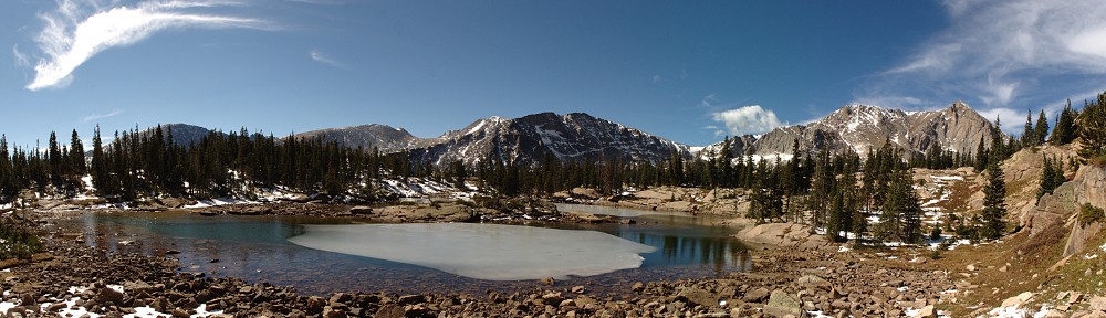
Recall that my plan was to contour around this ridge. From my map study, I decided the descent from the saddle was probably too steep for my comfort. But standing where I was I decided it really wasn’t that steep after all. I saw several lakes below me and headed more or less directly toward them, heading to the body of water at the top of the valley.

It was an easy descent, not too much loose talus. I quickly made it to the grassy meadows below. There I saw a few places where the grass was matted down where four or five elk or other large animals had lain down. A bit farther along, I saw an elk lying in a meadow and got the camera ready for a picture. Taking off the lens cap, I inadvertently clicked it against the barrel of the lens. The elk snapped his head in my direction and upon seeing me, he got up and cantered off to the trees toward my right. Dang.

By now it should have been obvious to me I wasn’t where I intended to be. I expected to make about a thousand foot descent from the ridge to the gorge. I probably only went half that distance. The lakes I was going to were substantial, all easily visible from Trail Ridge Road. The ponds I was heading to were much smaller. But I was blissfully unaware. It was a pleasant day and I was in beautiful surroundings. And I have a strong sense of direction.

IMG_9843sI had veered left when the elk ran to the right. A few minutes later, the elk dashed from right to left not far in front of me, followed by another one I hadn’t seen a few moments ago. I snapped a couple photos as they ran by, then continued to the pond in front of me. After a few minutes at this pond I headed down the valley to visit the other “lakes” I had spied from above. The walking was easy. There were a few marshy spots but the few clusters of willow were easily avoided.

I hiked from one lake to another, thinking that if I managed to stay high enough along the base of the ridge I’d soon come to Arrowhead Lake. I made it to the end of the ridge without coming to anything remotely like Arrowhead Lake and still hadn’t realized I wasn’t in the right place.

IMG_9856sOn many of these off-trail hikes I’ve come across piles of bones, bleached white. Some ribs or vertebrae, perhaps a pelvis. Always more than a single bone, always less than a full skeleton. Sometimes I can’t decide what sort of animal it was, and it’s never clear to me how long these bones have been there. This time I found a single leg bone, with skin still attached. Where’s the rest of the beast? Did some carnivore or scavenger make off with just this one?

By noon I had been through this valley without finding a pleasant shore for my picnic, so I found a nice outcropping of rocks with a view of Trail Ridge Road opposite. It was quite hazy due to forest fires in distant Idaho and the clouds didn’t look very entertaining so I didn’t bother setting up the cameras.

IMG_9870sAfter lunch, I worked my way along the ridge in the direction of the Mount Ida trail and an easy hike back to the car. Here well off the trail I found a bit of a puzzle. What is the purpose of these funnels? They don’t look like rain gauges to me, and they’re not hooked up to anything.

I quickly regained the trail and made a mental note of where the hiker should leave the trail to contour below ‘Jagor Point’. Ha ha. I made quick time back to tree line where I ran into a group of hikers led by a ranger. A bit farther down the trail I heard a commotion ahead of me and spotted an elk trotting down the trail. I followed him, snapping pictures. He caught up to a friend where the trail switches back. The two elk continued south, I followed the trail north.

I was back to the trailhead by 1:20, the earliest return to the car all summer. I figured I’d be home pretty early, easily by 4:00. After all, it only took me two hours to make the trip in the morning. It couldn’t take an extra forty minutes due to traffic, could it? Silly question. Of course it could. About a half mile before reaching the Rock Cut I found myself in an impromptu parking lot. This was clearly more than a half dozen cars ignoring the signs instructing drivers not to stop on the road, taking pictures of elk in the far distance. I got the camera out and spied flashing lights at the Rock Cut parking lot. Somebody was having a bad afternoon. We were stopped here for more than a half hour.

When I got home, I consulted the map and compared it to my notes. I visited a lake at 11,500′. There is no lake in Gorge Lakes at 11,500. Nor at 11,350′. So I finally accepted that I’d made a major navigational blunder. But no matter. As I always say when I fail to reach my desired destination, “There’s always another day.” I had a very enjoyable walk in the park, saw some wildlife in its natural habitat, got some exercise, and had a picnic above treeline. What’s not good about such a day?

Maybe next time I won’t forget my map.