Thursday, July 14
Today will be an easy day. It’s only about three hours to the motel in Willows. So I took my time getting packed up. Chatted with a fellow from Huntington Beach who used to own a Porsche Speedster. The car gets a lot of attention on the road, but very few people approached me to talk about it in the campground.
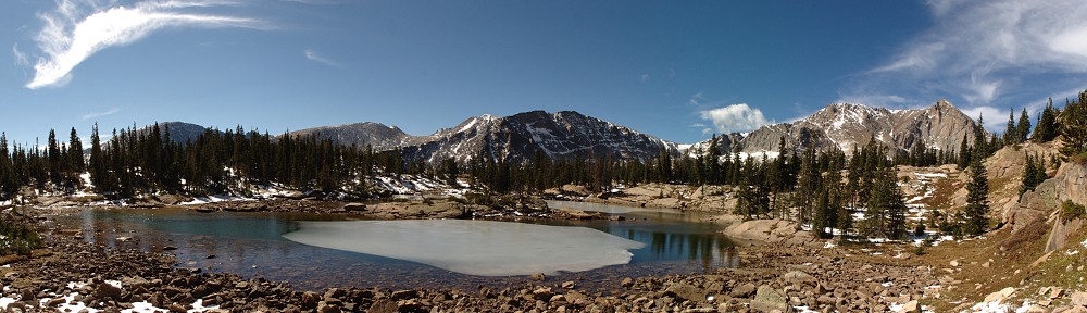
With some time to kill in the park, I decided to hike to Terrace Lake. There are actually two lakes here, almost adjacent, the other being Shadow Lake. On the map, Shadow Lake looks pretty big and the trail goes right along the shore. Should be tough to miss. I head down the trail, encountering quite a bit of snow. At times it’s a little tough finding the route. A few minutes later I arrive at a trail sign: Terrace Lake is .3 miles down the trail to the right.
I head down the trail to the right. I hike quite a long way without seeing any lakes at all. Before long I figured I’d gone a mile but I decided to carry on. I soon reach another trail junction. This one says Terrace Lake is 1.7 miles up the trail I’ve just come down. Clearly, somebody moved these lakes. You’d think somebody capable of finding more than eighty lakes in RMNP should be able to follow a trail to a couple of lakes here. How can both signs be wrong?
Shortly after turning around my mind wandered back to the question of “what if it erupts now?” This time it would take me an hour to get back to the car, but everything is in the car, so that’s good. I’m amused that I went down this line of thought once, let alone twice. The chances of this thing going off are orders of magnitude less than of me getting hit by lightning or getting in an auto accident. I never ponder those things.
There’s a large down tree that crosses the path; a section has been sawn out. The diameter of this tree trunk is four and a half or five feet. I was curious how old it was but the cut was old and rough so I couldn’t tell. Gave it a good look both times I passed it; it may have been the most interesting sight on the hike.
I arrived back at the trailhead just as a guy is starting down. He had spent the night at the same campground, but Loop A instead of Loop B. He hiked as far as Cliff Lake yesterday, said it was the best hike he’d been on. He asked me what I thought of Terrace Lake. I told him I couldn’t find it. He aborted his hike. I’m sure he’ll find it eventually, as he lives in Red Bluff, only about an hour away.
I stopped at the visitor center on my way out and bought a shirt. Still no cell service here, but another text message arrives. I’ve heard quite a few odd accents and foreign languages so far on this trip. A German family was in line in front of me. I’ve heard Spanish, French, Dutch, German, Polish, Korean, Japanese and probably a couple more.
On the road again, I turn right on CA 36. Very quickly, two motorcycles and a giant truck catch me. I’m only doing 5 over. The bikes pass me on double yellow. They pull off at a country store a few miles later so the road in front of me is clear. The big truck is getting big in the mirrors. I pull over and let him pass. It’s a big timber truck, with no cargo. He’s carrying his rear wheels rather than pulling them. Before long he’s out of sight. We hit a series of increasingly tight turns: 35mph, 30mph, 25 mph. I finally catch him but when the road straightens out, he’s pulling away again. At an intersection he pulls off to the right and waves at me as I pass, then he makes a left turn (where a fully loaded timber truck is arriving).
By now the road has fallen about a mile. The high point, at the summit parking lot, is about 8,500’. Now we’re around 3,000. No longer in subalpine forest we’re in widely dispersed scrub oak and yellow grasses. Still falling, we drop through vineyards. In the end, we fall to almond orchards and olive orchards fifty feet above sea level. We may as well have fallen all the way to hell: the sun is harsh here, and hot. And the air is hot. I’ve been cold quite a bit so far on this trip; I haven’t complained because I knew I’d remember it fondly.
I have lunch at the Applebee’s in Red Bluff. I sat at the bar. Everybody knows the bartender and waitress; they’re all locals.
It’s hotter than hell here. My phone says it’s 87, but it’s gotta be more like 100. I have 45 miles of Interstate to deal with next. I-5 is heavily traveled and carries lots of trucks. Most of the cars are left-laniacs, never getting out of the left lane. Before long we arrive at a construction zone. Right lane closed, I think it said, but there was only one sign. I’m in the right lane. I figure I’ll do a zipper merge when the lane is actually closed. Only a few of us attempt this; we pass about a half mile of cars.
Check in at the Motel 6. No carpet, no shampoo in the bathroom but no worries, I brought my own. First on the agenda is a cool shower. Need to wash off several layers of bug spray, sunscreen, and sweat. Next is laundry. Somehow I manage to forget to wash any of my shorts, but the shirts, socks, and underwear clean. Except one pair of hiking socks cleverly hiding in my hiking shoes. Dang.
This is the closest motel to the track. There are two or three more within a quarter-mile, but this is the cheapest one. I took a short walk, not much to see. There’s a State Trooper office and two restaurants that appear to be closed in addition to the other motels. When I got back I took a look at the cars in the parking lot. A couple of nice Audis, a Corvette, an old Mitsubishi with some stickers on it. I would likely see all these cars tomorrow.
I’m disappointed that I didn’t get to see Bumpass Hell. That was number one on my list. I understand they’ve been working on it quite a while, and still have a way to go before they’re finished. Comparing Lassen to Bryce or RMNP, it’s more like Bryce. It’s all about the volcano. It encompasses the volcano and a few surrounding features. The road probably couldn’t have been better sited to allow access to all the interesting features of the park. This has the effect of making many of the hikes “upside down”. Many of the trails descend from the road – you hike down when you’re fresh and it’s cool, you do all the work after you’ve walked quite a way and it’s hotter. All the Bryce hikes were upside down, too.
There are 150 miles of trail in the park, 17 of which Pacific Crest Trail. Based on the amount of hiking I log in RMNP, I’d be able to hike every mile of the Lassen trail system in two summers. I really enjoyed my short stay, and I’d still like to see Bumpass Hell.