Lake Verna 2

Imagine a verdant shelf set high on a stately mountainside above an unspoiled, heavenly creek valley. Add a series of lovely lakes to ornament the shelf and place it in a location so remote that few humans would ever have the ambition to go there. Put it all together and you’ve got Ten Lake Park.

— Lisa Foster

I studied the map of the terrain between Lake Verna and Ten Lake Park for quite some time. The first thing I noticed is that there aren’t ten lakes in Ten Lake Park. My map shows only five. And three of those look more like puddles than lakes. Regardless, it looked to me that I might be able to reach the place. I know that a forty-foot contour interval on a map can hide a multitude of terrain that might give me difficulties. But half or a bit less of the way was in forest so route finding should be simple for much of the way.

Tuesday, August 18

We had another leisurely morning. I slept until nearly 7 and we took our time with breakfast. We started off at about 9:30. The smoke cleared considerably overnight.

The obvious route from Lake Verna to Ten Lake Park is to follow an unnamed creek up the eastern flank of Mount Craig. Once out of the trees, look for the pass between the two prominent points east of Mount Craig. Cross the pass and descend into Ten Lake Park.

Rather than backtrack the quarter-mile to the creek, we crossed East Inlet west of the creek and went up the slope toward the creek at an angle. It was fairly steep for my taste, but there wasn’t much deadfall. Still, it was slow going. We came to a bit of a cliff that we bypassed by crossing the creek. After crossing the stream again, there was a big section of slick rock we had to cross that bothered me. I knew I’d be able to go down it but I also knew it would have my heart rate up.

We often looked back at where we’d just been, making sure we got a good look at the route from this vantage. Ed stacked up some cairns as bread crumbs. He used a couple chunks of wood as a marker where no stones were available.

Mount Craig on the right, our route to the left

As we climbed, the forest thinned and receded from the creek, which ran through a grassy meadow filled with wildflowers. Most were still blooming nicely, but the Elephant Heads were past their prime.

We saw only a few small lingering drifts of snow. Earlier in summer, these grassy areas are filled with water; big spongy masses. But now that the snow has melted and we’ve had about half the normal precipitation this year, things are dry. Judging by the watermarked rocks, the creek was running at a small fraction of its spring flow.

Not long after coming out into the open, we came to a gully on our left that climbed quite a way. I suggested that what we saw was the pass we were looking for. This proved to be a … well, not a false summit but a false pass. We weren’t so much looking for a gully as a grassy ramp. When we got to the top of our false pass we spotted the real thing.

Or, more accurately, a choice of passes. We could continue up and left, climbing a wide grassy area or a slightly steeper, narrower, rockier one a bit to the right. It looked like the one to the right was a bit lower and would be a few steps shorter, so that’s where we headed. It didn’t take us long to reach the top and take in the view of the other side.

Ten Lake Park

I knew going into this that there aren’t actually ten lakes in Ten Lake Park. And I know that these sorts of places can look considerably different in, say, June than in mid-August in an abnormally dry year. A little trickle of water emerged from a nearby spring, making a narrow band of green across an increasingly brown expanse. Below us, we could see a couple of small lakes and ponds, along with two dry lake beds.

In an ideal world, we’d have taken some time to enjoy the place, but it was approaching 1:30 pm, and assuming it would take about as long to return as it did to get here, we’d be back in camp well after 5. So, after a quick reconnaissance of the upper reaches of the park we turned around and climbed back to the pass.

Our view of Mount Craig as we descend

The descent down the slopes and gullies was fairly quick and painless and once back into the upper reaches of the forested slope below us, we came upon the first of the cairns we’d set up earlier. We successfully found our route in, and Ed knocked down the cairn as we passed it.

Approaching the top of the slick rock we crossed on the way up, we made a change to our route. On the way up we saw a game trail at the top of this rock. Deer and elk won’t often cross rock like this and we figured it was worth a shot at following the game trail. As often happens with these things, it looked good for a while before petering out. But we continued to go down the steepening slope, climbing over the occasional dead tree trunk, regaining and re-losing game trails on the way.

It sometimes seemed these game trails haven’t seen much use lately, but there is game in the vicinity. We came across some deer in the upper meadows and here in the forest we came across a cow elk with two or three calves still in spots. We didn’t spy any moose, but there was ample evidence of their passage, and I don’t mean footprints.

Ed is a big fan of glacial knobs. At one point in our descent we had a very nice view of the opposite slope, which is the southern exposure of Andrews Peak. To Ed it must have looked like glacial knob heaven.

As on our way up, we crossed to the west side of the stream on the way down. This time we didn’t recross it and stayed to the west. The slope was not quite as steep here, and we had a relatively easy time of it. Before long, we saw the East Inlet just below us. The stream is wide and shallow here and Ed just headed straight across. I’d have followed, but I don’t hike with poles and without poles I’d have undoubtedly slipped so I went upstream to find a crossing more to my liking.

Our return trip was quite a bit faster, taking only two and a half hours. In retrospect, we could have spent a bit longer at Ten Lake Park. But the future is hard to predict, and we did start getting rained on a bit on the lower portion of our descent. I’m not at all unhappy with our little hike.

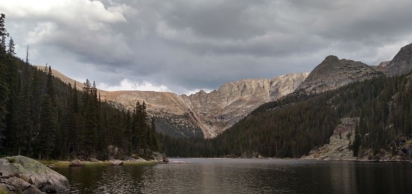
I found the upper area of this unnamed valley beneath the eastern flank of Mount Craig quite beautiful. Add a small lake here and it might even be ideal, but I’m a big fan of alpine lakes so I admit my bias.

It should come as no surprise that we encountered no other people on our little trek. In fact, we saw no sign that people had ever walked here before us. At some of my more remote destinations, I wonder how many other hikers make the trip in a year. I often see cairns or bootprints and surmise dozens or maybe a hundred. Here, perhaps only a handful of people come through here each year.

Because we were back in camp a little earlier than planned, we had a bit of an extended evening. Although the smoke from the wildfires was quite mild in the morning, it had steadily increased throughout the day. Now it was quite thick. I couldn’t taste it yet, but the odor was very noticeable.

The late afternoon saw a succession of rain storms. That overstates it a bit: we got sprinkled on several times. The smoke made it nearly impossible to tell if clouds were overhead, but we were still seeing our shadows, so we kept telling ourselves that the rain wouldn’t last. It never did, and the little rain had no effect on the smoke.

In fact, it might have been tempting to think that our sprinkles of rain had somehow turned to a light sprinkling of snow. But it wasn’t snow, it was ash. Each little particle of ash was rectangular, rather than the hexagonal shape of an individual snowflake. Like snow, sometimes the individual rectangular ashes clung together making larger bits of ash.

The big fires that I was blaming for the smoky air are well to the west of us. The nearer fires are north and south. And so I was quite surprised to note that the ash was falling on us from the east. I’m guessing that this was ash from the Cameron Peak fire, which is the nearest one, and so the complex winds along the Continental Divide carried this payload east, then south, then west.

The ash fell all evening, but the smoke thankfully never got much worse.

We nearly went the entire day without seeing or hearing another person. Sitting in camp chatting, we heard nearby voices. I climbed to the top of a rock where I could see the trail along the shore of Lake Verna and spotted one hiker. Unless she was talking to herself, there was at least one more hiker. Nonetheless, I can’t think of a day in the Park when I saw so few other people.

As the sky darkened and the stars started to appear, we could tell that all the clouds were gone now, we would get no more sprinkles, and if ash was still falling we could at least no longer see it.

Wednesday, August 19

We awoke to another beautiful RMNP morning. Like yesterday, the smoke was much reduced. And no more ash was falling.

We were packed up and on the trail not long after eight. We made somewhat better time on the way out and were back to the trailhead at about 2:30. In all my years of hiking the Park, I can probably count on one hand the number of times I’ve seen horses on the trail. I see lots of road apples, but not many horses. In addition to the two horses we met while on our break on Devil’s Ladder on Monday, today we were passed by two park rangers on horseback, leading two pack horses. And closer to the trailhead another pair of riders. I think Ed was trying to work out how big of a bribe it would take to ride out rather than to walk.

At the trailhead, there was a ranger picking up litter. It’s sad that this is a part of anybody’s job. Why do people go looking for wilderness and then promptly pollute it?

Another ranger was at the trailhead checking timed entry passes. This trailhead isn’t outside the Park, but you don’t have to go through an entrance station to get here. When we arrived on Monday there was nobody performing this check.

Ed stopped in Grand Lake for some ice cream before we re-entered the Park for the drive over Trail Ridge. Approaching the entrance station, Ed’s ice cream cone suffered containment failure and he nearly wore the last few bites.

To the north were the smoke plumes from the Cameron Peak fire. The smoke blew to the east, and when we descended down the east side of the Divide we drove down into quite a thick soup. Some rain clouds made it look even darker but a look over our shoulders when we passed Deer Mountain showed us that the smoke here was much, much worse than we dealt with on our hike.

Final Thoughts

I’ve hiked the East Inlet Trail three times now, once as a day hike, once with a one-night stay, and now with a two-night stay. I’ve visited all the places along this trail that interest me with the exception of Adams Falls, which is the easiest feature to visit on this trail.

In general, the valley of the East Inlet is a beautiful place to visit and worth the effort of climbing all those stairs. And Devil’s Ladder is a dramatic piece of trail offering an expansive view of the Grand Lake area.

More specifically, our visit to Ten Lake Park was a bit of a challenge but, I think, well worth the calories burned.

Lake Verna 1

My second backpacking trip of the year is a two-night stay at the Lake Verna campsite. This is very similar to my trip two years ago when Gordon and I stayed one night at the Upper East Inlet campsite with the goal of bagging Fifth Lake. That was the trip where I learned I need to spend two nights in camp instead of one. One day to hike in, a day to visit whatever the real goal of the trip is, and a day to hike out.

In that earlier trip report I went on a bit about the condition of the trail. Specifically, that there are an almost uncountable number of stair steps to negotiate and there are quite a few impressive retaining walls and bridge abutments. It’s what I would call a “highly engineered trail”. Rather than repeat that, I’ll go into some of the trail’s history. Much of this info comes from an application the Park made to get the trail into the National Register of Historic Places.

Unlike the North Inlet and Tonahutu Creek, the East Inlet doesn’t offer any sort of easy route from Grand Lake over the Continental Divide. Which is to say that before about a century ago there were no existing trails through the valley. According to Charles Edwin Hewes, a local who wrote about his tramp through the valley, no feasible trail existed there in 1913. That summer, the Estes Park Trail (before it was the Estes Park Trail Gazette, I guess) said that “a new trail was made from Grand Lake to a chain of lakes six miles east of Grand Lake.” It would seem that this could only be describing the East Inlet.

The Trail does not name a trail builder, but in those days trails were often made by lodge keepers, guides, or other locals. Just because Hewes didn’t find a trail doesn’t mean one didn’t exist. It could mean that the trail was a more casual, less permanent style of trail that Hewes and his hiking group could have missed. Lodge keepers weren’t professional trail builders and didn’t have the resources for developing sustainable trails.

In 1919, Roger Toll, who would later become a superintendent of RMNP, recommended that mountaineers who wanted to get up the valley should just follow the waterway rather than to find a trail. In 1922, when he was superintendent, Toll reported that the trail was blocked by a rockslide near Lone Pine Lake. One would think that he wouldn’t report a trail closure unless there was a trail there. Park records don’t mention any trail construction there between 1919 and 1922.

By 1923, the East Inlet Trail had gained some popularity with the tourists. It also gained a bit of a reputation for being dangerous among local guides. The section called “Devil’s Ladder” was notoriously tricky for horses. Fred McLaren, in his first year as ranger, watched his horse slide over Devil’s Ladder and down the hill. I’m guessing it wasn’t one of the steeper bits, as the horse was just a little spooked. McLaren went to the superintendent (Toll, I believe) and suggested that if the Park supplied the food, locals would volunteer to do the work. In 1924 and 1925 such a crew built a new trail through the Devil’s Ladder area and made a handrail out of pipe. That handrail is long gone but the careful observer will note a couple remnants of it today.

In spite of McLaren’s efforts to build a sturdy, sustainable trail all the way to Lake Verna, in 1931 the entire trail was considered “poor”. In 1931 and 1934, trail workers redeveloped the section between Lone Pine Lake and Lake Verna. I don’t know how much of the work was done in 1931 as opposed to 1934, but I suspect the bulk of the work was done in 1934. This section is remarkable today for it’s extensive dry-rock walls and intricate bridge abutments. In the summer of 1934, Roosevelt’s Public Works Administration funded two shifts a day to make these improvements.

In 1935, there was some interest in connecting the East Inlet Trail to the North Inlet Trail. This would have been accomplished by a route over the saddle between Mt. Alice and Andrews Peak. A survey was completed, but given the great distance from both trailheads, it’s not surprising that this was never done as it would get very little traffic.

Another big improvement project was completed in 1940 when the Civilian Conservation Corps worked on the section between Adams Falls and the Devil’s Ladder. Then in 1970, another $70,000 project was implemented. This was mainly for improved sustainability rather than any realignment of the trail. Many older rock walls still remain, although the pipe handrail at Devil’s Ladder was removed at this time.

The official Park trail ends at Lake Verna, but an unimproved and unmaintained “fisherman’s” trail continues on to Spirit Lake, Fourth Lake, and Fifth Lake.

Which brings us to…

Monday, August 17

I reached out to Ed a couple of weeks in advance. I talked him into meeting at his place and having him drive to the trailhead. I said that because we had all day we didn’t need to get too early of a start. So I told him I’d be there at 8 am. He said that would be okay, but pointed out we’d be hiking in the heat of the day.

The other concern had to do with smoke. Specifically, from either the Cameron Peak fire, burning just north of the Park, or the Williams Fork fire, which is a bit farther from the Park and to the southwest. The prevailing winds blow from west to east, so I didn’t expect smoke from those fires, but I did expect smoke from the larger, more distant fires at Grizzly Creek and Pine Gulch. I may have been a bit cavalier about the smoke: I suggested that if it was too bad, we’d just cut our trip short.

We were on the trail just a few minutes after 10 am. The weather was sunny and warm, with isolated clouds. The smoke wasn’t too bad. It was much worse in Denver on Friday, where visibility was quite limited and I could taste the smoke when I was in my back yard. Today I couldn’t smell it, let alone taste it. But it certainly didn’t look good.

Having all day, we made a leisurely time of it. We stopped for a lunch break halfway up Devil’s Ladder. We were in a relatively wide spot. Most of that section is quite narrow, particularly in these days of COVID. But we found a spot with a view that was wide enough to not cause a problem. And we put that to the test when two horses came up the trail. They were able to pass us with no difficulty. We took another break at Lone Pine Lake and even spent a few minutes admiring the stonework on the walls and bridges above Lone Pine Lake.

Climbing Devil’s Ladder

It was about 6 pm when we arrived at Lake Verna. There, we met two young men lounging by the water. They asked if we were staying the night and volunteered that they were camping at the Lake Verna campsite. “That’s our camp,” I told them. Ed and I went up to the campsite where we found their hammocks and gear all set up. There is only one campsite here, and it’s ours. When they came up from the lake I asked them if I could see their permit.They were supposed to be at Upper East Inlet.

We chatted a bit while they packed up. I felt a bit bad, but not that bad. It only took them a few minutes to get their stuff together. While they were packing they told us they’d just graduated from college and were making their way across the West. After RMNP they’d visit Flaming Gorge and Yellowstone. They had no reservations, but would take whatever was available when they arrived. That’s how they got Upper East Inlet. I’m a bit surprised it was available. I’m pretty sure it wasn’t available when I made the Lake Verna reservations back on March 2nd. Somebody probably cancelled due to COVID and these gents benefited.

Calm and somewhat smokey Lake Verna

In spite of our relaxed pace on the hike in, we were both pretty tuckered out. I managed to remain conscious quite some time after sunset. There’s not much sunset to see from here, being obscured by mountains and trees, but through some of the trees we could see the decidedly orange tint of the sunset. Until the stars began to shine, I wasn’t sure whether we had “clear” skies or clouds. Once the stars started coming out, we could tell there were no clouds. The stars directly above us twinkled normally, but those just above the nearby mountains were tinted orange from the smoke.

A tiny tree growing out of a giant stump

Tomorrow’s goal is Ten Lake Park.

I fell asleep fairly quickly.

Fifth Lake – Day 2

Sunday, September 2

We were up and shortly after 6:30. In theory, as neither of us planned on a hot breakfast, we should have been able to start our journey to Fifth Lake well before eight. In practice, it wasn’t until 8:30 that we put boots on trail. We packed everything up into our packs which we left at the campsite partially covered by a log in case it rained.

On last month’s trip I packed my day pack in the backpack. After posting that trip report, Ed mentioned that he had a Kelty pack that had a day pack incorporated into it. After playing around with mine I discovered that mine did as well. I don’t like the little day pack bit as much as my lumbar pack, but I’d certainly give it a try. Not having to carry the extra equipment would save me some space and weight.

So in the little pack I carried a bottle of water, some food, and my rain jacket. Somehow I neglected to put the GoPro in it. I was a bit disappointed in my forgetfulness, but I didn’t want to turn around to get it.

Lake Verna pano

When I see pictures my other hiking friends post online I’ll admit I’m a bit jealous that they get so many shots of lakes with mirror-smooth surfaces. As a day-hiker, I’m never at any lakes early enough to see them before there’s any breeze. So I was quite pleased to see Lake Verna and Spirit Lake in such calm conditions. This is definitely an advantage that offsets carrying a heavy pack and sleeping on the ground.

Gordon on the beach at Lake Verna

Another distinct but mistaken memory I have is of the trail between Spirit Lake and Fourth Lake. I vividly recall coming to a split in the trail and having to choose whether to step across the stream and cross a meadow or stay to the left. I went right and ended up in a bit of a marsh. I navigated to higher ground, then found another game trail that deposited me in another marshy meadow. Today I came across no such split in the trail, and where I expected to find two or three meadows found only one.

Spirit Lake and ‘Aiguille de Fleur’

That is not to say that there weren’t any splits in the trail. As one progresses farther west from Spirit Lake the trail often becomes braided. Part of this is due to the many downed trees to be negotiated. In a number of places I took one fork of trail and Gordon took the other. We always came back together after a few dozen yards. So although the trail becomes indistinct and braided, it doesn’t really seem to matter.

Spirit Lake

After Fourth Lake, East Inlet makes a turn to the south. Or, rather, flowing down a steep hill, the stream turns from flowing north to flowing west. The trail is quite faint after Fourth Lake but not terribly difficult to follow. For quite a while it continues east and goes straight up the slope. A fair way up the hill we decided it was time to strike off the trail and back towards the stream.

Fourth Lake

Route finding was simple and we found ourselves hopping from rock to rock until we arrived at the stream itself. Although it’s called East Inlet, here I want to call it the outlet, as it’s the outlet of Fifth Lake. In early September the flow is quite diminished but based on the color of the rocks you can tell that the stream often flows much higher. We arrived on the shore of Fifth Lake by about 10:15.

The morning sky was still almost cloudless, so had I not forgotten the GoPro I wouldn’t have had a very interesting time-lapse. A few jetliners crossed the sky leaving contrails that dispersed into fat white ribbons and a half moon floated above the opposite ridge. Much of the lake was still in the shadow of the spectacular ridge of the Continental Divide. As the sun rose, it didn’t so much climb above the ridge as traverse it, moving behind first one peak then another, putting us alternately in shade, then sun, then shade again.

Fifth Lake

We weren’t the only ones there. A lone fisherman was working his way around the lake, casting his line in several different places. After about half an hour we headed back down. Arriving at Fourth Lake we spotted two moose wading across the lake. We kept an eye on them and they kept an eye on us. Gordon suggested they might be the same two moose we saw yesterday. If we made it here, they certainly could have too. I have my doubts that they’re the same moose but who knows.

Gordon scanned the opposite shore with is binoculars and spotted a bull moose in the trees. If Gordon hadn’t pointed him out to me I’d have never seen him. I could see him but any picture I took with the cell phone wouldn’t show him. The moose worked their way to the outlet stream and we found our paths converging.

Moose wading in Fourth Lake

Here we met a couple guys hiking up. They left the trailhead at seven this morning, arriving here at Fourth Lake at 11:40. They didn’t realize where they were. Their goal was Spirit Lake. I told them they were at Fourth Lake, gave them my map, and suggested they try to get to Fifth Lake. I somewhat expected to see them again on our hike out as they were moving quite a bit faster than us, but we never did see them again so I don’t know if they made it.

Pika

We were back at the campsite a bit before 1:00. This is somewhat later than I was hoping but not a concern. It took us about five hours to get here yesterday, and I typically don’t hike out any faster than I hike in. That could mean we don’t get back to the car until six. But we make it to Lone Pine Lake in half an hour and don’t take any breaks until we crossed the bridge over the river another half hour below Lone Pine. We stopped there for more water.

About ten minutes before reaching the bridge I heard quite a loud noise somewhere below us. I can’t really describe it, and at the time I had no idea what it was. My first thought was that it was man-made, but I couldn’t imagine how it was made. I didn’t give it any more thought until a couple hundred yards down the trail from our break at the bridge. A dead tree had fallen across the river, landing on a large rock slab that the trail crossed. The trunk had been burned, was black. Where it hit the rock it was broken in a couple places. Broken but not quite shattered. This, obviously, was the source of the noise.

I was a bit surprised at the number of hikers on the trail. My last visit I only saw a handful of people. But that was a weekday and this is a holiday weekend. Still, the number of people hiking up toward Lone Pine Lake this late in the day was unexpected. Closer to the trailhead, one couple asked me how far to the lake. I told them we’d been hiking for about two hours; they turned right around. Another woman passed us asking if the moose was still there. Last moose we saw was at Fourth Lake.

Yours truly, crossing a bridge just above Lone Pine Lake

We finally made it back to the car at around 4:30, maybe a little later. It felt like a long day. I won’t say the last two miles were agony, but I really struggled. But every worthwhile thing has a cost. The valley of upper East Inlet is gorgeous: large, beautiful lakes beneath stunning peaks. We couldn’t have had much better weather. We had some threatening clouds but never got rained on, and when it was sunny it wasn’t hot.

Just another beautiful day (or two) in the neighborhood.

Fifth Lake – Day 1

East Inlet is a stream that flows roughly ten miles from the northern flank of Isolation Peak to the eastern shores of Grand Lake. There are five lakes along this stream, like beads on a string: Lone Pine Lake, Lake Verna, Spirit Lake, Fourth Lake, and Fifth Lake. They ran out of names.

I tried to get to Fifth Lake back in 2009. That was the first year that I kept a log of my hikes, but before I was blogging. I attempted it as a day hike, hitting the trail at 7:30 and reaching Fourth Lake at noon. As that was my “bingo” time, I stopped there, ate my picnic, then headed back. I returned to the car a bit before 5:00. Given that it might take about an hour to get to Fifth Lake from Fourth Lake, I figured it was out of range for me for a day hike.

If I can’t do it in one day, perhaps I should try it in two. So when March 1 rolled around I went online to make a reservation for one night at the Lake Verna campsite. I didn’t get my request but when I visited the back country office to make my reservation for zone camping for my Gorge Lakes hike, I managed to negotiate a good alternative. The Lake Verna campsite was booked up on all the dates I was interested in, but Upper East Inlet was available for September first. It’s just a couple tenths of a mile below Lake Verna so there’s no real functional difference.

The plan was to hike in to the campsite on day one, rise early on day two to get up to Fifth Lake and back to the campsite around noon, then hike back to the car. When I made the reservation, I didn’t have anybody lined up to accompany me but I booked it for two people anyway. About a week ago Gordon volunteered to go.

Saturday, September 1

Because we essentially had all day to get to Lake Verna we made a leisurely start, putting boots on the trail at about 10:00am.

It has been nine years since I hiked this trail but I have a few very distinct memories of it. I remember encountering a bull moose just below Lake Verna with a lame left front leg. I remember it being on a section of trail that traversed a rather steep treeless slope. There is no such section of trail. I’m the first to admit my memory isn’t the best, but in this case it’s a pretty disappointing mismatch. As to the rest of the trail, only a couple of short sections of that hike stayed with me. So in a sense, much of it was somewhat like being on a trail I’d never hiked before.

On that hike long ago, I found a moose in the marshy meadow quite near the trailhead. Today we found two moose even closer to the start. They were quite near the trail. Almost too close for comfort when I realized it was a cow and yearling calf. I probably have that nomenclature wrong. It was a young moose, but now nearly fully grown. I know moose can be unpredictable and wouldn’t want to get between mother and calf.

These two were quite calm, probably used to being in the presence of people. The only other time I’ve been this close to a moose was that earlier encounter on this trail with the lame one. We quietly watched them for a few minutes and took a few pictures. As they slowly worked their way into the trees and away from the trail, the cow let out an odd little moan, then pooped. I realized I’ve never knowingly seen moose poo before. Last year I learned that much of what I’ve taken for years to be deer poo is actually llama poo. This year I learned that moose poo looks a lot like horse poo.

Lone Pine Lake is the first lake in the chain, 5.3 miles and 1500 vertical feet from the trailhead. The first two miles or so follow the stream as it meanders through a broad marshy valley and gains only about a hundred feet. After that easy first two miles, the trail climbs about 1400 feet in just over three miles. This section of trail goes through some fairly rugged country, and the trail between here and just above Lone Pine Lake is what I’d call “highly engineered”. There are a number of stretches where you climb rather a long series of stone stairs.

When we got to the campsite it seemed to me like we’d climbed a thousand of these stairs. That’s a ridiculous number, obviously. When we got to the first of these on the way down I asked Gordon how many he thought there were. “I don’t know. 232?” I said it seemed like a thousand, even though that was an exaggeration. I said that I didn’t intend to count them, but then went ahead and counted anyway. I lost track a couple of times, but by the time we got back to the car I’d counted 725. The actual number is probably between 700 and 750. Those are just the obviously engineered stairs and doesn’t include the many rocks that naturally lie on the trail or are set to divert rain water off the trail.

In addition to the many stairs, there are long lengths of trail that lie on top of carefully built stone walls. There are also some spots where the trail was laid on a ledge that was carved out of large rock outcroppings. Some serious work went into constructing this trail. I really appreciate it, as when looking at the terrain from below it doesn’t look like the kind of country I would be willing to cross without a trail.

I don’t know the fire history of this area. None of it has burned since 2000, but there’s a pretty good section that looks to me as if it has recently burned. There aren’t any large swaths of dead trees, but the tree trunks for quite a stretch of trail look like they’ve seen some fire. There’s one stretch of stone stairs that I recall quite well from before and through here it seemed to me that there were quite a few more downed trees now than then.

We stopped for a rest perhaps half way up the climb to Lone Pine Lake. That’s not half the trail distance, but half the climb, so maybe three and a half miles in. To that point I thought we were making pretty good time. But carrying the pack was starting to wear me out. We took another break at Lone Pine Lake. I really struggled to get there, as I wanted to stop about half an hour earlier. But Gordon took the lead for a while and convinced me to continue until we arrived at the lake.

Lone Pine Lake

It was nearly 2:00 when we got to the lake, and we paused for about fifteen minutes. The weather forecast for the area called for a 60% chance of rain in the afternoon, with some snow possible overnight (with “little to no accumulation of snow”). The skies by now were clearly threatening, with the occasional rumble of thunder. So we didn’t delay too long.

It’s just over a mile and a half from Lone Pine Lake to Lake Verna, and our campsite is a couple tenths below Verna, so we didn’t have much farther to go. Verna, Spirit, and Fourth lakes lie in a valley that hangs above Lone Pine. There’s not much elevation between those three lakes, but the trail climbs a bit over two hundred feet in the next half mile or so. This is another highly engineered stretch of trail that includes a few bridges and a rather large retaining wall. The trail tops out on a rock outcropping with a nice view of Lone Pine Lake.

Above Lone Pine Lake

From here to the campsite it’s pretty easy walking; a nearly straight line for about two thirds of a mile. The campsite itself is a few yards north of the trail, up another thirty or forty feet. It looks like a number of rather large dead trees have recently toppled, their thin disks of soil and roots standing upright. The large trees were dead, but in toppling they took with them some young, live trees. These were still green, so they haven’t been down for very long. I’m sure that if anybody was in the campsite when the trees came down it was quite thrilling.

Upper East Inlet campsite

After we set up camp we headed to Lake Verna. On last month’s trip, I carried two full bottles of water. This time I carried both bottles but only one was full. I figured we’d never be far from a water source so I didn’t need to carry the extra weight, but at camp I’d probably want to have more than one bottle of water, given I’d use something like half a bottle to cook my meal. After I filled my bottle, we sat there and watched the world go by for a little while.

Lake Verna, early evening

Back in camp Gordon surprised me by pulling a couple cans of beer out of his pack: Left Hand Brewing Traveling Light Kolsch. Much the way that I find a peach always seems to taste best when on the shores of an alpine lake, I was quite satisfied with this tasty little Kolsch, even though it was warm.

By sunset the clouds had cleared and by the time I turned in, the first stars in the night sky were shining brightly above us. Had I tried to stay up long enough, I might have seen a little sliver of the Milky Way as the moon wouldn’t rise for a few hours yet. I was happy that the 60% chance of rain hadn’t materialized, other than a few sprinkles when we sat at Lake Verna. With no clouds overhead at sunset, I was confident we wouldn’t get rain (or snow!) overnight.