Friday, September 25
We awoke to another beautiful day in the neighborhood. That is, I should say “I awoke” because Gordon had a sleepless night.
Last night when I hit the sack, I plugged my phone into my battery. For some reason, the phone insists on being powered on when it’s charging. It read 46%. A few minutes later, it read 47%. Good, it’s charging. When I woke up, the phone was at 0%. The cable had come undone and the phone just ran down.
This is a bit of a problem. The phone is my only camera. The SLR, which failed on the Renegade trip, was still not back from Canon. I plugged the phone back into the battery and set it on a stable base. It got up to 38% by the time we hit the trail a bit before nine.
This might be the time for peak aspen in the Park, I don’t know. There aren’t many aspens in the valley. It’s all pine, so you might not expect much color. You’d be wrong. In this pine forest, the autumn colors are on the ground. The leaves go from green to green and yellow to yellow to gold then a bright red and finally to a dull brown. Sometimes large areas are all one color, sometimes all the colors show up within a few feet.

I’d said that we’d be to Nokoni in an hour (which is what it took yesterday) and to Nanita an hour after that. As expected, it did take an hour to reach Nokoni, but we made it from Nokoni to Nanita in forty minutes. None of that territory was new to me. I had also said it would take another hour to get to Catherine. That turned out to be quite optimistic.
We made our way across Nanita’s outlet and quickly found a game trail. I thought of yesterday’s ranger calling them “moose trails”. I’m not sure why I found it amusing, but I did. You know you’re on a good game trail when you keep finding poo. Elk pellets and moose patties.
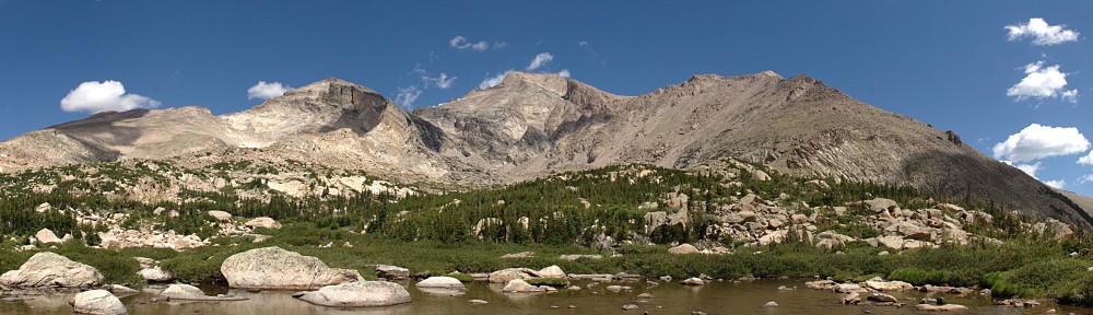
It didn’t take us too long to get out in the open. There are three great cirques between Ptarmigan Mountain and Andrews Peak. To our right we had a nice view of the one closest to Andrews. The ramp we were climbing got pretty steep. I took my time, often checking out the view behind me.

The top of the saddle is 600′ above Nanita. Catherine is 800′ below us, but out of sight around the corner. Directly in front of us, about a mile away, is a pass, another saddle. There’s a small pond there, a couple of hundred feet below the top. A century ago, there were plans to make a trail connecting Spirit Lake and ‘Lake Catherine’. Presumably, that is where the trail would have gone.
There at the top Gordon and I parted ways. He wanted to take a more direct, slightly steeper route to Catherine. I opted for the longer, shallower arc, out of the trees. It was nice, easy walking for the most part, generally following game trails. Only as I approached the lake did I need to get back to the edge of the trees to avoid giant boulders.

I got to Catherine at 12:30, so three and three-quarters hours. I found Gordon, who said he hadn’t been waiting long. But he is a patient man, so he may have been enjoying the wait. We scouted the northwestern shore for a place to snack and relax in the sun but out of the wind.
We spotted a promising place nearly opposite us, but on closer inspection, the trees there were swaying pretty good in the wind. We continued along the shore. The spot we eventually picked was pleasant enough, a few chill gusts excepted.

Gordon couldn’t resist pointing out that he put all this effort into getting to one of the least visited lakes in the Park, only to find me there, too.
After our relaxing picnic, we started our bushwhack. I have a good idea that Foster would call it an “arduous bushwhack”.
One of the great things about hiking at this time of year, other than the fantastic colors on the ground, is that everything is much dryer. All the streams are running quite low and are much easier to cross. The grassy marshes are more grass than marsh now. This would be much more difficult earlier in the season when it’s all wet.
According to the map, it didn’t matter which side of the outlet we descended until we came to a pond two hundred feet below the lake. At this pond, we’d need to go down the right side to avoid some steep terrain. We had good game trails and there wasn’t too much deadfall.

Below this pond, things got interesting. It was easy going when we had game trails to follow, but we started coming across denser deadfall. We didn’t worry too much about staying close to the stream, all we had to do was go downhill. Maybe half an hour after leaving the pond we came across a stream. I thought, “Ah, a tributary!” But checking the map, we’d arrived at the North Inlet. Although the stream we’d been following from Catherine carries about the same volume of water as the stream that flows from Lake Powell, it’s farther to Lake Powell, so that stream is the North Inlet while the one we’d been paralleling has no name.
We didn’t need to cross the North Inlet so we didn’t. Yet. We followed it for just a few yards before returning to our unnamed stream. This we crossed. After a while, we decided that the “grass was greener” on the other side of the North Inlet, so we crossed it. This we did a few times before we were done.
Once, on the north side of the stream, our game trail petered out in a mass of deadfall. We were working our way slowly through here when we heard an elk bugle. I asked Gordon how far away he thought that was. A few minutes later through the trees he spotted a bull and some cows about a hundred yards ahead of us, crossing our path, headed uphill. The bull stopped and bugled. Given how far the sound travels, I expected it to be much louder. Another bull some ways behind us bugled a response. How close was he?
We worked our way through the deadfall and had easy going for only a short distance. We entered another pile of deadfall. This one, though, was different. Instead of the trees lying in random directions, here they were all facing one way. And the dead trunks weren’t still connected to their roots. The roots were still in the ground, with stumps two or three or four feet tall, splintered. This is an avalanche debris field.
Crossing the North Inlet for the last time, we began searching for Lake Solitude (not to be confused with Solitude Lake, in Glacier Gorge). This is a small forest lake with no inlet or outlet. In the proximity of Solitude, the stream meanders through a large open meadow. We wandered around a bit, backtracked a little, made at least a token search for it, but didn’t stumble upon it.
The rest of the way back to camp, there weren’t any serious obstacles. There weren’t that many game trails, either, but so it goes. Before we knew it, we spotted Gordon’s hammock. Home again, home again, jiggety-jig!
We left Catherine a few minutes after one and arrived in camp at 4:30, so we managed about a mile an hour. I’ve done worse. My trip to Julian Lake a couple of months ago had some brutal stretches. And up Spruce Canyon with Gordon last year we could only manage half a mile an hour.
To celebrate the completion of our little odyssey we drank the rest of the beer Gordon carted up and had dinner. The skies weren’t quite clear, just some thin, high clouds; a lacy veil that slightly diffused the light of the gibbous moon.
Before dusk, another helicopter flew over. It followed the trail up the mountain towards the Divide. A few minutes later we heard another chopper, but couldn’t spot it. Maybe it was the same one, on its return trip. This was not the cargo helicopter, I think it was the same kind as the one I saw on my Hunters Creek hike – a rescue chopper.
Not long after, Gordon spotted a blinking light on the mountainside across from us. It was random, intermittent. It didn’t take us long to see that it was not one but several lights. We discussed it: we agreed it probably wasn’t aliens, and elk don’t generally carry lights. It had to be people, right? What were they doing up there, wandering around like that? Was it a search party?
Well, I didn’t print a map of that part of the trail. We weren’t going that way, and I didn’t pay particular attention to the layout of the trail. I knew there were a couple of large switchback sections, but thought they were farther up the valley, out of our sight. I was wrong. The first switchbacks, climbing six hundred feet, were directly in front of us. We’d been watching a group of six or eight hikers work their way down the mountain on the trail.
Tonight, Gordon gave up before I did. I wasn’t as cold as I was last night, so wasn’t in as big of a hurry to climb into the warm sleeping bag.
We didn’t see another person all day.
Saturday, September 26
I took my obligatory excursion at one. The thin veil of clouds was gone, the air was calm.
We were packed up and on the trail a bit before nine. It took us four hours to hike in, we should be able to beat that by a bit on the way out. On most backpacking trips, the pack weighs heavily on my back on the hike out, but today I felt pretty good.
We ran into another ranger. This one was hiking in. When we came upon him, he was talking to a woman backpacker on her way out. We chatted a bit. I asked if there was some search operation last night. There wasn’t, so we were seeing hikers. The woman somehow knew that a group had gotten a late start. They didn’t make it to camp (or out? I’m not sure) until 11:00 pm.
We told him we’d been to Catherine. He said, “People used to walk all through these forests twelve or fifteen years ago. Not as much now; there’s too much deadfall from the pine beetle.” He told us he was working “pre-rescue”. He was on the lookout for people “wearing flip-flops and not carrying any water.”
As we got closer to the trailhead, we encountered more and more hikers. At first, I was counting them. Once they started coming in groups of four or six or more, I switched to counting dozens. In the end, I figured it was 8 or 9 dozen. I couldn’t help but wonder where they all parked. I don’t think there’s room for much more than a dozen cars in the lot. (Most of them were parked on the paved road a quarter-mile below the trailhead.)
I did get a bit of a kick from some of the questions people asked me. “Did you make it all the way? All the way to the falls?” The falls are the first point of interest on the trail. Yes, I made it “all the way”. Another one saw my big backpack and asked, “Are you backpacking?”
Back at the trailhead, I was happy to be done.
But, boy, what a satisfying trip! The weather was great, the scenery awesome. I felt great the whole time. We saw an elk bugle, marveled at mysterious lights, and went to one of the least visited lakes in the Park.