I don’t know what I was thinking. Obviously, I wasn’t. To think that I’d be able to reach Isolation or Frigid Lakes in early July is pure fantasy. So if you’re just curious what I found at either of those lakes, I’ll save you the trouble: I didn’t even make it to Bluebird Lake.
I ended up with a permit on this date because this site was already booked on the weekends later in July. For some reason, I fixated on doing one of my overnight trips in July, and only considered dates that included at least one weekend day. I could have had a date later in July had I been willing to do it in the middle of the week. Or, I could have had an August or September date had I been willing to make two trips in either of those months. But I was unwilling to take, or didn’t consider, those options.
But clearly taking a mid-week hike in July to try to bag Isolation and Frigid would have failed just the same. Certainly, this year. We had a very wet spring and there is still a lot of snow on the ground in the high country. That much is obvious from Denver.
The plan was to hike in to the Upper Ouzel Creek campsite, spend the night, explore whatever territory I could above Bluebird Lake for a day, spend a second night, then hike out on the third day. Even before setting out I knew it was unlikely I’d reach my goals. But so what? It’s a few days in the backcountry.
I filled the backpack with the usual stuff, then added more stuff. For these overnight trips I haven’t been taking the SLR. I decided to take it this time. I’ve been concerned about having my phone or GoPro batteries die, so I took along a battery that I could use to charge them. And, of course, the associated cables. And I knew I’d be trekking across a fair amount of snow so I included the micro-spikes.
Saturday began mostly overcast, but that changed as I approached Allenspark, where all skies to the west were a clear, clear blue. I wanted to arrive at the entrance a few minutes after eight. My permit was for 2 people in the party. I had asked Ed if he wanted to join me. He was in, until he was out, and a substitute could not be found. So I wanted to tell somebody that my party was just me.
At the gate at 8:10, they told me I might not get a parking spot. I was a bit concerned by this very thing; that’s why I wanted to be there pretty much as soon as the entry station was manned. Much later and the lot would be full for sure. When I got to the (first) bridge across the river I ran across a volunteer. She flagged me down. I told her I was backpacking and she said they generally save a spot or two for permit holders. But we happened to be in a radio dark spot and she couldn’t contact the other volunteers. She warned me that I might end up in the winter parking lot. Nothing like adding another mile to the trip!
At the trailhead lot I managed to shoehorn the car into a spot between a truck and an SUV. I had told the first volunteer at the lot that I had a permit, and asked where to park. He just told me to look for a spot. The second volunteer remarked that I’d parked where he didn’t know there was a spot, then said “You should have told me you have a permit. We have a couple spots saved!”
I was on the trail by a quarter to nine. That’s a bit later than I usually start on this trail, because on my day hikes I need to be six or eight miles in by noon. No such restriction today: I had all day to do about six miles. So I took my time.

I’m using a backpack a friend gave me. This is my third trip with it. I’ve decided it’s too small. Other than that, I like it. Well, except that I can’t get my water bottle properly secured when I have the backpack on. I can get the water bottle out, but can’t put it back in properly. So, at least when I’m going solo, I have resigned myself to taking an extended break every time I want some water.
Then there was an additional break when I realized I’d packed my sunscreen in the bear vault. So much of this hike is in direct sunshine that the old SPF is in no way optional. It’s never optional for me, but especially so on this trail. So I stopped where the trail splits and Ouzel/Bluebird is to the left, Thunder/Lion to the right. And again along the top of the ridge where regrowth in the burn scar hasn’t blocked the view up the canyon. And again where the trail splits between Ouzel and Bluebird. Did I mention I was taking my time?

I know people generally aren’t big fans of forest fires. I figure they’re a natural part of the life cycle of the forest and try to take the bad with the good. This area burned back in 1978. About ten years ago, along the top of the ridge above Ouzel Falls, you still had unimpeded views of all the surrounding terrain. But now the new growth is getting taller and thicker. Open views are still common and shade is sparse, but the forest is returning here.
Tree growth is considerably slower up higher, and by the time the trail is even with Ouzel Lake, it looks a lot like it looked in the first few years after the fire. The ground is covered only by grasses and a scattering of wildflowers. A few dead trunks stand upright over their fallen neighbors, and the trail is lined by raspberries for long stretches.
Along the way, I talked to a pair of twenty-something women and a thirty-something couple. It struck me that in both discussions we described the terrain in fundamentally different ways. They all oriented around peaks, I orient around lakes. I know the names of many of the mountains, but too many of the names are just names. I know Mahana Peak and Tanima Peak are around here, but it’s not important to me to know which ones are which. So there was some back-and-forth in these conversations translating geography: Hunters Creek to Mt. Orton, and the like.
When I got to about the end of the burn scar on the Bluebird trail, I ran into a guy in black shorts and no shirt that had motored past me earlier. “If you’re going to the lake, you may want to reconsider. I made it 95% of the way there, but had to turn back due to all the snow.” I asked if he made it to the campsite but he didn’t know. He showed me on his map how far he thought he’d gone.
I mounted the micro-spikes and continued. It was pretty easy going, but lots of big snow drifts to cross. Before long, it’s snow as often as not. Did he think this was too much snow, or that next stretch? Then I arrived at a place where I had to traverse high up on a steep snowbank. Even with traction, I didn’t like the looks of it. Without the backpack I’d have done it. It was an easy choice to descend a bit and climb some rocks rather than risk a fall.
As I started down, another couple caught up to me. She wanted to follow the tracks, but he thought my way was better. Turns out this is their third attempt to get to Bluebird Lake. First was in December. They snowshoed. They only made it to Ouzel Falls and the round trip was seven hours. Then in May they made it to “that boulder right there”. They swore they’d make it this time.

I pushed on a little farther, then took a breather. They took a breather then pushed on, and we happened to reach the spur to the campsite at the same time. They started up toward the campsite. I told them where they were going and pointed the other way. “See that log bridge over there? You go that way.” I’m absolutely certain they didn’t go much farther and will soon be making their fourth attempt.

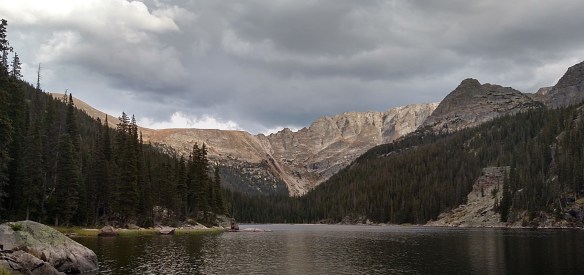
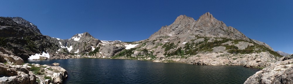
I was relieved to find the campsite free of snow. It was not exactly dry, though. It was pretty obvious that water had flowed here quite recently. Flowed here and puddled there. Luckily, the least wet spot was almost exactly the size of my tent. I got it set up then took a jacket and some water and headed up to Bluebird Lake. I quickly found myself at the bottom of the last steep bit to the lake. Later in the summer, this little section is one of my favorite fields of wildflowers. But right now it’s just snow.
So that’s where I stopped. In snow shoes, with an able companion, I’d have done it. With just the micro-spikes and solo, no way.
And that’s when I decided I didn’t need to stay two nights up here.
I sat for a while beside the stream, the outlet from Bluebird. The water was running fast and clear; a distinct blue. It cascades out of a tunnel it’s bored through the bottom of a huge drift of snow. The sound of the water was, in a way, intense. It is unwavering. It’s not as loud as nearby thunder, but it is certainly louder than the wind through the trees. It’s quite loud.

By about six I made my way back to camp. It’s a nice camp. The view from the pad itself is nice, but it’s atop a large rock outcropping. A few feet down a gentle slope is a half log, seats two. Twenty feet below is the trail. I sat here after dinner and watched the shadow of the setting sun climb the flank of Copeland Mtn.
Although I’m a fair distance from the stream, the sound of rushing water is a dull roar, louder than any airliners passing overhead. I can’t see my stream, but across the canyon I can see six significant water falls. There’s still so much snow here, water is flowing everywhere, (except, thankfully, for my campsite).
By eight it was time to turn in. There wasn’t anything to watch for a while, and I knew I’d fall asleep before I’d get a good look at the night sky so I set an alarm for ten. Had to use the phone because the Fitbit wouldn’t sync with my phone without internet access. At ten, there were some scattered clouds. The crescent moon had set, or at least fallen behind out of sight beyond the divide.
I was awake again at 3:30 for a comfort break. The clouds had cleared and the Milky Way was spilled across the sky. I rarely see the Milky Way. Seems like few times I get to experience a dark sky, the moon is always shining brightly.
Surprisingly, I was able to sleep almost until seven. I took my time breaking camp and was on the trail by a quarter to nine. I hadn’t seen any big mammals on the hike in, but did see a solo deer in the evening and three more in the morning, below my porch.

I was not exactly looking forward to putting that backpack on. Because it’s too small, almost none of the weight is on my hips; it’s all on my shoulders. My shoulders are sore, it it would be nice to have a day off. My one adjustment is to put (clean) socks between my shoulders and the straps. This worked better than anticipated. The discomfort was much reduced and I didn’t feel the need to stop as often. It took me more than six hours to go up, but not much over four on the way down.
Although I didn’t get to where I wanted to go, and I spent one night instead of two, I still had a good time. Any day in the Park is a good day.
No time lapse this trip. But there’s this, instead.