Monday, July 13
I was awakened at about five by the patter of rain falling on my tent. It stopped after twenty minutes or so but returned for shorter showers at six and six-thirty. The rain was light enough that by seven, nothing was wet except my tent’s rain cover, not the rocks, not the stumps, not the logs.
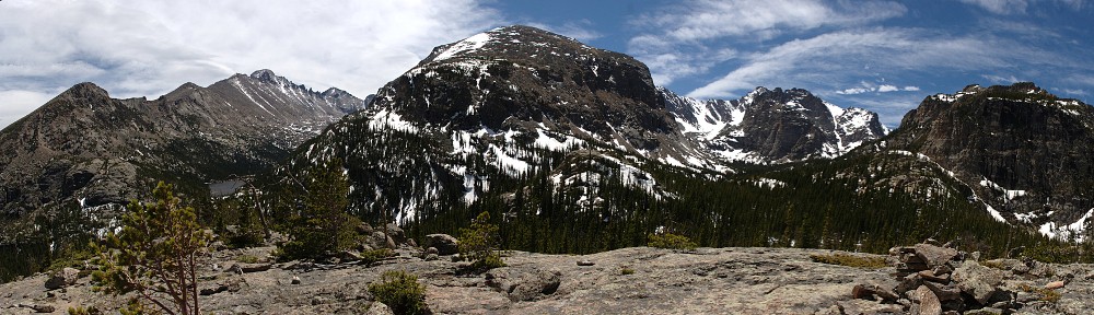
The plan for the day was to first visit Murphy Lake. After that, we figured we could head north across the tundra to get a look at Spruce Canyon from above, to see Rainbow Lake and Irene Lake, which I failed to reach last year. Finally, given enough time, we could perhaps even summit Sprague Mountain and take a gander at Lonesome Lake. It’s good to have goals, even if sometimes one’s reach exceeds one’s grasp.
We had a short (very short) discussion as to whether the best way to Murphy Lake was to bushwhack along a straight line down one side of the valley and up the other or to take the trail to a point a bit above treeline and contour around to it. In my map study, I never considered the first option; Gordon brought it up. It’s good to have options. But in this case, I felt it would be much simpler (and perhaps easier) to go with Plan A.
So we left camp at eight, putting Plan A into motion. The Tonahutu Creek trail here is surprisingly busy. It’s not the sandals and no-water people and it’s not day-trippers: everybody we saw on the trail was backpacking. And I’m pretty sure the smallest group we met was four people. We didn’t meet all the people we saw on the trail; we spotted quite a few hikers when we were a fair distance off-trail.
We followed the trail until we were at about 11,600′ elevation then headed more or less southwest. The map shows a couple of streams we’d need to cross, which is never a problem here above the trees. We would also pass by two unnamed ponds. Looking at the map, it seemed the best way to go would be to cross this second stream below the lower pond and follow the contour.
Somewhere in here, I lost Gordon. One minute he was right behind me, the next he was gone. I made a brief search before continuing on my own. He has a map and he knows where we’re going, so I didn’t worry about him.

I reached one of the ponds and decided that I was exactly where I wanted to be. Then, a few minutes later, I saw that I had crossed the outlet stream of the upper pond rather than the lower one, so I was forty feet higher than I planned. I adjusted my route a bit, then found myself at the top of a large talus field. “Talus” probably isn’t the right word. The rocks at the top of the field, beneath a rock outcropping, were giant boulders and thus much more difficult to navigate.

That’s when Gordon reappeared. He suggested we work down some more and pass below the boulders. He found an easy route, and we were back in business. We crossed a series of alternating fields of talus and grass. The grassy bits were probably flowing with water a week ago. Now they were mostly dry. The grassy bits aren’t like your lawn. The grass grows in tiny hillocks; tufts of grass standing eight to twelve inches proud of the ground, almost like grassy toadstools. When wet, there’d be flowing water between them. Best to step on them rather than between them.
From the map, I was expecting the whole route to be above the trees. This was not the case. There were trees, but not many of them. They stood in small groups that were widely separated. They served as navigation aids and allowed us to more easily judge distances. There was no krummholz, and what little willow we encountered wasn’t more than a foot tall and had many passages. The whole way, the only difficult bit was the short section of boulders we had to go around.

We arrived at Murphy Lake at 10:30. It is nestled beneath the five hundred foot tall cliffs of the northern arm of Snowdrift Peak and a permanent snowfield. Just as we arrived, we heard the crashing of rockfall – rumble, crash, rumble. It took a few seconds to stop. We’d have had to be looking in exactly the right spot to see it, and localizing a noise in this echoey place is very difficult.

We only relaxed here for half an hour, as the next leg of our tour would be above treeline. And it’s generally a good idea to get back into the trees early in case the weather gods decide to throw a thunderstorm in honor of your presence.
Wanting to avoid the one difficult spot we passed through on our way here, we took a slightly different route. We found a nice grassy ramp down with a grassy looking gully up the other side. I’m not generally a big fan of giving up elevation only to regain it, but it looked like a pretty good route. It turned out to be the outlet of the lower pond, so we were now on the route I was hoping to take on our way in.
We refilled our water bottles from one of the many rivulets, about the purest snowmelt water one will ever find, just meters below the source. From here we spotted a bull moose in a grassy/marshy area below us. Could this be the same bull I spotted when getting water last night? I wonder just how big the moose population is around here, and how far each moose might range.
We could also see hikers on the trail in the distance. With his binoculars, Gordon counted nine people in the group. We weren’t so much interested in locating the trail as crossing it, and our only real concern there was picking the easiest way to the saddle that overlooks Rainbow Lake. We identified this fairly easily and set off.
The walking wasn’t difficult. Route finding is fairly trivial here at the top of the world; there are no hidden terrain features. But we were somewhere near 11,600′ above sea level, and headed to a point 700′ higher. I’m not a swift hiker in this environment. One might be tempted to make a joke about the air being thin enough to provide less wind resistance. That joke won’t fly, particularly today, when the wind is blowing steadily at thirty or forty miles per hour.
Rather than reaching a spot with a view of Rainbow Lake, we climbed only about another hundred feet to hit the somewhat lower saddle to the right of it. This gives a view of Spruce Canyon. I wasn’t thinking clearly at the time. The four lakes we hoped to get last year in Spruce Canyon aren’t actually in Spruce Canyon; they’re on shelves to the north. From our current vantage point, no lakes were visible. I was mistakenly thinking we’d see Loomis. We didn’t take in the view for very long, as the wind was so fierce that neither of us wanted to stand too close to the edge. Our hats were nearly blown off our heads; we carried them almost back to the trail.

At this point, I’d had enough. To get a view of Rainbow and Irene, we’d have had to climb another five hundred feet into the teeth of this gale. The white puffy clouds we watched at Murphy were growing more threatening, growing dense and dark to the west. It was time to put an end to our exploring.

I really would have liked to have seen if any of these lakes are within my grasp from here. The descent from the divide down to Rainbow Lake (and Sprague Tarn and Irene Lake) is a class 3 according to Foster’s guide, so most likely beyond me. But, having not laid eyes on it, I’m still under the impression that I might be capable of climbing down to Lonesome Lake. It is more difficult than reaching Murphy Lake. It’s about the same distance from our camp but requires an additional 1,400′ of elevation gain. Until now, I had considered Lonesome Lake as one I’d never be able to reach. I’d sure have liked to put eyes on the route, but if I think if wanted to do another two-night stay at Renegade I could give it a shot.

We regained the trail and headed back towards camp. Back on the trail we encountered hikers going in both directions. Someone in every group we met asked us where we were staying. This almost never happens to me: usually I’m the one asking people where they’ve been and where they’re headed. But this whole trip I don’t think I got the question out first.
Of course, the audience matters. We were on a section of trail seven or eight miles from any trailhead, so these are other backcountry campers or long-distance hikers. I generally only quiz people when they are few and far between.
It was too early for me to eat lunch when we were on the shores of Murphy Lake. And there was no suitable spot on our trek to the overlook, unless you’re a fan of having a picnic in a wind tunnel. So we kept an eye out for a place out of the wind, in the sun, and with a view. We were nearly back to the Timberline camp before we found one.

We parked our carcasses on some rocks and tucked in. We were soon joined by a curious pika. She didn’t come right up to us, but was inquisitive enough to approach within a few feet. She’d pop up on a rock, sit there for a few seconds, then retreat, all to repeat a few minutes later. There were the usual ground squirrels, too. None was bold enough to sniff my pack, but I kept an eye peeled for a four-legged food thief.

Most of the weather looked to be sliding slightly to the north. I didn’t see any lightning, but we did hear the distant rumbling of thunder a few times. When we passed the Timberline camp, I took the opportunity to use the privy. Much better to use it now than to need it in the middle of the night, particularly given my headlamp situation.
It started raining lightly just as we returned to our camp. Just like this morning’s squalls, this one was short-lived. Being back in camp at the early hour of 3:30 meant we’d have a rather long stretch of down time. Gordon would be subjected to more of my stories, likely to hear some of them for the second (or third?) time.
For most of the first day of the trip, I hadn’t seen any marmots. I’d heard them barking at us near Haynach Lakes, but hadn’t spotted one. As it turns out, we found one rummaging around the edges of our camp, too shy to approach but proud enough to stand in profile, as if posing for a picture. We were also briefly visited by a pair of deer, who bounded quickly up the hillside just a few yards from camp.
I made another early evening of it, retiring again at nine. I was not overcome by biological imperative until 3 am this time. Again, the sky was cloudless and filled with stars.
Tuesday, July 14
We were packed up and on the trail by a few minutes after eight. The hike in took us a bit over four hours. I’m not generally much faster going downhill than I am going up, at least in “day tripper” mode. But what took four hours two days ago was done three quarters of an hour quicker today.
On the hike in, passing through the burned areas, I was wondering how long these dead tree trunks stand. The obvious answer is that some fall down sooner than others. Presumably, it wouldn’t take much more than a stiff breeze to knock some over. And, of course, a stiff breeze is not an unusual event in these parts. So I wasn’t terribly surprised to see that a tree had, in fact, fallen down since we passed this way two days ago. It was hard to miss, as it fell over the trail. I certainly wouldn’t have noticed it otherwise.
I’m often amused by questions posed by people. Sometimes I’ll be on a trail that reaches a series of lakes. I’m typically going to the highest, farthest one. That’s not the most common destination, though. I’ll be asked, “How much farther to the lake?” and know they’re asking about the first one and not the last one. Once or twice today people asked us if they were “nearly there,” presumably meaning Granite Falls.
Today’s amusing question was, “How far to the end?” This was on the first section of trail, from the Green Mountain trailhead to the junction with the Tonahutu Creek Trail. I suppose, technically, that’s “the end”, but to me it’s just a navigation point, not a destination. So I asked him, “What’s the end?” To which he replied, “Exactly! Am I right?” A deeply philosophical person, I presume.
I won’t say that last 1.8 miles was agony. I was tired and my feet were a bit sore, but mostly I was just ready to be done.
Overall, I count this as a very satisfying trip. My primary goal was to visit Murphy Lake. Unlike many of my recent hikes, I managed to attain my goal. I’d like to have been able to scout routes to the handful of lakes lying just below Sprague Mountain, all out of my reach using other routes. But I’m not disappointed that I fell short. The scenery was top-notch. The weather wasn’t perfect, but close enough. The company was enjoyable (although Gordon might disagree, having had to listen to me for three days).
The only bad news from the trip: When I got home, the first thing I did was charge the camera battery. It very quickly reached a full charge, so it clearly wasn’t dead. I reinserted it and turned the camera on, but no joy. So it looks like the camera is going to have to go in for repair.
Historical Addendum
Sitting in camp for a fairly extended time, it’s only natural (for me, anyway) to wonder about the history of the place. When was the campsite was created? Who made the trail, and when? I don’t have any answers regarding the campsite, but I did manage to unearth some fascinating history of the Tonahutu Creek Trail.
Back in 1914, during efforts to create the Park, very few places had names, and an effort was made to “fill out the map”, so to speak. So Miss Harriett W. Vaille, chairwoman of the Nomenclature Committee of the Colorado Mountain Club, arranged an expedition to escort two old-timer Native Americans through the area and have them supply the old names. Expedition leader Oliver W. Toll wrote a thin (46 page) book about the trip: Arapaho names & trails: A report of a 1914 pack trip. The two Natives, Gun Griswold and Sherman Sage, said that the Arapaho name for the grassy area we call Big Meadows was “tonalhuta”. If you guessed that “tonalhuta” translates to “big meadow” you hit the nail on the head.
The trail may have been in use as long as 9,000 years ago. Euroamericans used the route in the nineteenth and early twentieth century, but there’s no record of trail construction until 1924 when a crew under the supervision of Ranger Fred McLaren made significant improvements. I had guessed that perhaps the Civilian Conservation Corps worked on the trail, and there is a 1939 schematic plan for the CCC to reconstruct the first three miles of the trail, but it’s not clear that they actually performed any work.
Roger Toll (superintendent of RMNP for much of the 1920s, and not to be confused with Oliver Toll who went on to become a lawyer and who prosecuted von Ribbentrop during the Nuremberg war-crime trials) asserted that up until about 1900, the Tonahutu Creek Trail was the shortest route between Estes Park and Grand Lake and the most often used. That’s no longer true, as the North Inlet Trail now claims those feats.
McLaren employed a foreman named Parton and a crew of about ten men to construct the trail. When it was completed and opened in 1924, Superintendent Toll said, “Although several miles longer than the North Inlet Trail, [the Tonahutu Creek Trail] is the easier and more interesting trail. It is particularly well adapted to winter use.”
Oh, and about the derelict buildings. They are the remains of a cabin and barn built by Sam Stone. I’ve been unable to find any additional information.


