As I tend to do, I kept a browser tab open for about a week showing the topo map of the area I’m going to hike. This week, it was Betty and Bob Lakes in the IPW. They, and King Lake, form the headwaters of South Fork Middle Boulder Creek. (Last week I hiked along North Fork Middle Boulder Creek.)

I came up with all sorts of possibilities, most of which I discarded. In the end, my plan was to get to Betty and Bob Lakes, then do the side trip to King Lake. I had considered going cross-country from Bob to King but figured it’d be faster to use the trail even though it meant losing and regaining about 300′ of elevation. Another one I considered was skipping King and going over the ridge between Betty and Skyscraper Reservoir, collecting Woodland Lake, and returning by the Woodland Lake trail. This would have been the same mileage and elevation gain as doing Betty, Bob, and King. The big unknowable until reaching the top of the ridge is the state of the terrain on the other side.
Monday, July 22
Parking for the Hessie Trailhead is just a short distance past the town of Eldora, on the side of the road. The map indicates a road from this point to a small parking lot at the trailhead, but the road is closed now. It’s about half a mile to the parking lot. More, actually, because there were already ten cars parked on the road. Before I had changed into my boots, two more cars came in and parked.
When I put boots on the trail, the sun had not yet climbed above the ridge, so the area was in shadow. I was thinking I’d be walking on the old road, but right away the road wasn’t so much “road” as “river”. A narrow trail snakes alongside the road/river. It was dark, and last night’s rain still clung to the grass, leaves, and pine needles. The temperature was in the low forties and the humidity made it clammy. It felt a bit … primordial.
The trailhead is right on the river. (North Fork Boulder Creek. The North and South Forks have their confluence just out of sight about five hundred feet downstream.) The parking lot isn’t the end of the road. There’s a stout pedestrian bridge next to a wide, shallow ford for vehicles and livestock. The 4×4 road and trail are one and the same nearly to the IPW boundary. The road crosses the river again, this time using a fairly new bridge (South Fork this time). I’m guessing it was replaced after the 2013 floods. At this bridge is the junction with the trail to Jasper Lake, Storm Lake, and Devil’s Thumb Lake. You could use it for Woodland Lake/Skyscraper Reservoir as well.
Continuing up the road, we next come to a nice waterfall. Not far past the falls is the junction with the Lost Lake trail and a couple bends past that is the junction with the Woodland Lake trail (which could also be used for Jasper, et al). At this junction, we are finally off the disused jeep trail. I didn’t like the road – it was full of loose rocks. At times, I felt like a drunken sailor when a rock would shift underfoot. A quarter of a mile farther on, the trail finally reaches the boundary of Indian Peaks Wilderness, a mile and a half (or more) from the car.
Carved by glaciers, the valley is U-shaped, with the stream at the bottom and the trail a bit above the river, always audible but not always in sight. It’s a nice trail, of fairly constant slope, free of rocks and roots for extended distances, allowing for consistent strides. The forest obscures any surrounding views but isn’t dense – the trees are spaced farther apart than usual, and the sun illuminates the grass and flowers on the forest floor.
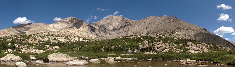
Approaching the head of the valley, the forest starts breaking up and the mountain to the south is revealed. Only glimpses to begin, but just before the trail climbs up off the valley floor we see the whole mountain flank. The Rollins Pass Road is clearly visible. There’s a short section where the trestles still stand, but most of the mountainside is littered with old lumber from the road.
The history of Rollins Pass is extensive, with archeological studies indicating it was in use as much as 10,000 years ago. The lumber strewn along the mountainside is what’s left of the snowsheds used by the railroad. Essentially, the snowshed was an almost continuous wooden tunnel that ran near the summit. The idea was to keep the railroad operational for more than just August (workers on the Moffat Road had an adage: “There’s winter and then there’s August”). The snowshed wasn’t a great success. Trains were often stranded for several days (sometimes weeks) during heavy snowstorms because snow could fall or be blown through the wood planking of the sheds. Coal smoke and toxic gasses from the locomotive collected in the snowsheds often causing temporary blindness, loss of consciousness, and sometimes death. The snowsheds are long gone, but the lumber debris has been there for a century and will likely be around for centuries more.
The map shows there’s a pond in the valley below where the trail snakes up the wall, but the map is incorrect. The trail tops out of its climb and reaches the spur trail to Betty and Bob Lakes. ProTrails says the section from the junction to the lake is tricky through willow and krummholz. I found it fairly obvious and easy to follow.
About three hundred feet higher than the trail junction we find Betty Lake. My plan was to skip right on by and take my first break at Bob Lake. Here is where I was foiled. The trail crosses the outlet of Betty, which flows through a bunch of willow. It flows fast and deep. There are two or three branches thrown across, but they’re old and small. When I put any weight on them, they bowed badly. It’s too far to jump. If I had bothered to bring my trek poles, I’d have crossed it without too much trepidation. But the risk isn’t just wet feet: I judge the water to be nearly thigh deep here.
The lesson here is to bring the poles on routes I haven’t traveled before.
I spent a few minutes looking through the krummholz for a dead limb I could use as a pole to make the crossing but couldn’t find anything. So I gave up and looked for a nice spot for a short break. I worked my way to the north shore and got the idea that I could get to Bob this way, but when I worked around to where I could see the whole route there was more willow than I wanted to deal with. So much for going to Bob.
I had a snack on the shore of Betty, but I didn’t linger long. I worked my way back down to the King Lake junction and headed up that way. The trail continues past the lake and up to the Continental Divide, reaching a parking lot on Rollins Pass.


A couple of hikers arrived just after I did. They wanted me to take their picture, and we chatted a bit. They left about the same time another couple hiked down from the pass. These two were from Arkansas and had rented a 4×4 for the trip over the pass. The guy stripped down to his shorts and took a quick swim in the lake.
I stayed at King for nearly an hour, ate my picnic lunch, drank my beer (Tivoli Brewing’s Mile Hi Hefe, which I’ll have to call “Two Mile Hi Hefe”), and watched the world go by.
The weather couldn’t decide whether to be threatening or not. A short squall blew over while I was going from Betty to King but it didn’t amount to much. After leaving King, I heard thunder to the north, but I could see no dark clouds and there were large patches of blue sky overhead. The thunder died out after twenty minutes or so, except for one late rumble perhaps fifteen minutes later.
On the hike out, I ran into a couple about my age. They were carrying backpacks and had with them three fully-loaded llamas. We had a quick chat. They were looking for nice camping spots near King Lake. I can’t help but wonder how long they were going to stay, and in what luxury. They must have had a couple of hundred pounds of gear.
When my water was two-thirds gone, I found a nice rock to sit on beside the stream. I ate my peach (a delicious Colorado Palisade peach: big, sweet, and juicy) and then refilled my water bottle.
I started early enough this morning that I encountered only two hikers between the car and the King Lake junction. It was quite a bit more crowded in the afternoon, particularly after I started passing the various trail junctions. I ran across so many people, I was trying to picture how far down the road people must have parked. I even ran into a group of four or five folks wearing flip-flops and carrying no water. I don’t imagine they made it too far.
Back at the car, I felt pretty worn out. But it was a good worn-out.
I’ll definitely do some more hiking from the Hessie trailhead. By missing Bob Lake this time, I have an excuse to do this trail again. Skyscraper Reservoir is still in use, so I’d like to get a good look at it and compare it to the former reservoirs in the Park. Counting the three lakes I tried to get to today, there are eight lakes on Hessie trails that are at roughly 11,000′ to 11,500′ in elevation within a mile or so of the Continental Divide.


