So, three months since I Iast posted. Not good.
I haven’t done a track day or a scenic drive pretty much since LOG. The car has been in various states of disassembly since the first of November. I’m happy to report that its current state of disassembly is “nearly reassembled”. I’ll have a full report on that when it’s done.
And yesterday was my first hike in ages.
Saturday, February 5
Chad reached out to me a while back offering to join me on my next hike. He doesn’t have snowshoes, though, so it meant sticking to the beaten path, or he could rent a pair. The third choice was to see if Ed wanted to take a walk with us: he has a spare pair of snowshoes. Ed, as usual, was up for a trip to Haiyaha.
Regular readers here know that I’ve been there many times. So there won’t be much to this report, as I don’t feel the need to repeat myself.
I woke up well in advance of my alarm and laid in bed listening to the wind rock the house. If it’s windy enough here to rock the house, I couldn’t help but wonder how bad it would be at our destination. I was thinking my day would be cold and miserable. I asked myself whose idea it was to go up there. Nobody to blame but me: it was my idea.
While I was awake well before my alarm, something went wrong with Chad’s. He called about the time he was expected here. I let Ed know we’d be a bit late. I was thinking we’d be 45 minutes late, but we made good time and got to the entrance station right at 8. This was perfect timing. Perfectly bad: if we’d been there a few minutes earlier, we’d have sailed right through. Instead, we were in a line of more than a dozen cars. Took us ten minutes to get through.
It was Chad’s first trip to Haiyaha, so every time Ed came to a picture spot, Chad took a picture. We had a bit of excitement when, at the second such spot, Chad realized his phone was missing. One of my snowshoes was coming off, so while I was fixing that, Ed and Chad backtracked. They found his phone pretty quickly. Luckily it didn’t hit the snow edge-on, as they may never have found it.
At the start, I told Chad that Ed knows every rock and tree in the area. He probably thought I was exaggerating. I’m not. When we exchanged greetings with the volunteers at the trailhead, Ed told them about a tree that had fallen. I guess it’s on the park trail from Haiyaha to Glacier Gorge Junction. He pointed it out to us when we got there.
You’d really need to know every tree in the area to know that a tree that’s on the ground in the middle of a forest is freshly fallen. The cool thing about this one is that when it fell, it “trimmed” a tree that it fell on. It looks like it fell directly on this other tree, or maybe an inch or two from dead-center: every branch and limb of this still-standing tree was torn off one side of the trunk, right at the trunk. Quite the pruning job.
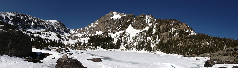
The main attraction of Haiyaha, for me, is the ice. (Yes, I’m repeating earlier reports.) The lake has a leak. Ice forms on it, the water drains, and the ice drops several feet. Large rocks poke out like volcanoes, breaking the ice into large slabs. Given the luxury of moderate weather, you can spend a fair amount of time inspecting the ice: the different hues of blue in the different light, the columns of frozen bubbles, the wind-carved surface ripples.
Today, the weather was not moderate. It was quite nice in the forest, out of the wind. But, as usual in winter, the lake (and any other lake just below the Divide) is like the floor of a wind tunnel. I took a few pictures, but the conditions were a bit on the brutal side. I couldn’t keep my gloves off very long; they quickly got almost too cold to work the camera. I keep trying to get pictures that do the ice justice, but I’m just not that good.
We quickly decided to cross the lake and take our lunch break in a clump of trees on the other side. On our way, we watched some snowboarders make a short run. In the trees, mostly out of the wind, Ed showed us how to make a bench out of snow. We sat on the bench and ate. I usually like a leisurely meal, but not today. Even rushing it a bit, I was pretty quickly cold and wanting to get moving again. We all had our gloves off to eat, and my fingers were very cold by the time we got moving.


I had the GoPro with me, but on arrival at the lake the skies were clear and there wasn’t really any point in getting a time-lapse. Along the ridges, though, the wind was blowing so hard that the snow formed clouds along the ridges and the summit of Longs Peak.
It only took a few minutes of hiking to get me warmed back up, and I could feel my fingers again.
I don’t hike with trek poles. I bought a pair when I bought the snowshoes, used them once or twice, didn’t see the point and don’t really want to carry them around if I don’t find them worth it. I admit that on many hikes, there are occasions where I wish I had poles, but I always manage without. Today I figured I’d give poles another chance.
Two things I note: first, I experienced a bit of fatigue in muscles that I don’t normally exercise when I hike. Not a big deal, but by the time we got back to the car, I was tired of “carrying” them. Second, I found myself mesmerized by the sound they make in the snow as I pivot the pole. Not exactly the crunch of snow under a boot, but not far from it. Faint, but enough that I could feel the vibration in my hands. I really don’t know why I was so fascinated by it.
Back in my misspent youth, I hiked to Emerald Lake every Memorial Day every year for fifteen years or so. I don’t go there that often. Instead, it seems I’m now doing a mid-winter hike to Haiyaha. It’s not a bad trade.


