Saturday, July 10
I think this is the sixth time I’ve visited Andrews Tarn, most of those back in the 1980s. The first two visits, we hiked a loop: up Flattop Mtn, along the divide, and down the glacier. Back then, the foot of the glacier was in the tarn, rising perhaps eight or ten feet above the water. My previous visit was back in 2007 and I was disappointed to see how far the glacier retreated. Today, there’s still snow on the ground between the glacier and the tarn, so I couldn’t tell how much smaller the glacier is now than it was forty years ago.
This is my first experience with the timed entry passes for the Bear Lake corridor. A permit is now required if you want to go to any destination on Bear Lake Road. The passes begin at 5 am and the last time slot available is 4 pm. For my purposes, only the 5 am and 7 am time slots will work. When I arrived at the entrance station, a few minutes before 8, they had all but one lake closed with traffic cones. And there was nobody in the booth. A few yards up Bear Lake Road they check your permit and give you a permit. They said, “Put this on your dashboard” but it has a post-it note sort of adhesive and it looked like most folks stuck it on their windshields as I did.
Unless I’m in the park well before 7, I don’t bother trying to park in either the Glacier Gorge or Bear Lake parking lots. I pulled into the park and ride to see quite a long line waiting for the shuttle bus. Face masks are required on the shuttle. If you don’t have one, they’ll give you one. The driver’s area is closed off to the rest of the bus, so everybody boards and exits through the back door. (Not really a back door, but you know what I mean.)
The Foster guide says 4.6 miles and a vertical climb of 2,200′ to the tarn.
Follow the crowd to the Loch and keep going up the trail to Sky Pond. At about three-quarters of a mile after reaching the Loch the trail crosses Andrews Creek. If I didn’t know there was a trail here, I wouldn’t have seen it. There’s a sign on the south side of the trail, but it was in dark shade. And the first few yards of the trail to Andrews is solid rock.
At this point we’re about three-quarters of the way there but we’ve only climbed a bit more than half the total: the last mile climbs a thousand feet.
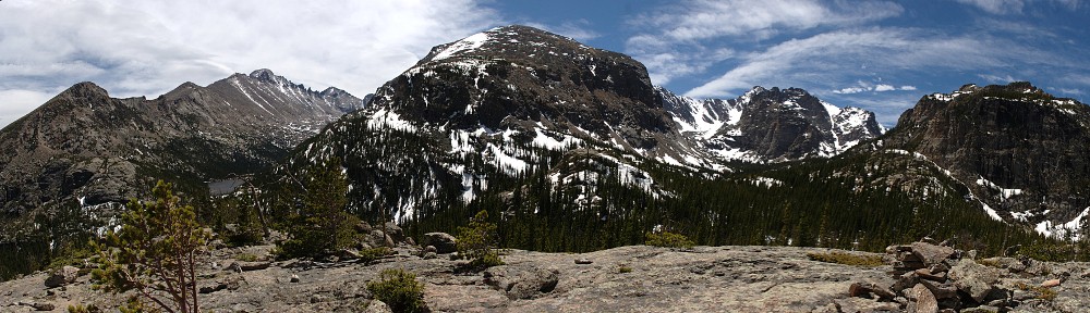
The trail climbs on the west side of Andrews Creek. The trail bends slightly to head due north. Fairly quickly you arrive at the Andrews Creek campsite. It’s off to the right; the trail continues to the left, now going pretty much due west. Not long after that, you leave the forest to find in front of you a canyon full of talus. On the right, the north, is the eastern arm of Otis Peak, towering twelve or thirteen hundred feet above the trail.
The trail now alternates between a crude trail and sections of rock-hopping across the talus. It seemed like there was a small cairn every few yards, which seemed excessive. By now we’re well over ten thousand feet, and the one-in-five climb is starting to take its toll. I figured I have all day – it’s not a long hike, and I got a fairly early start. I took several breaks.
At one breather, I chatted with a hiker who caught up to me. He had a slight accent. I asked where he was from. “It’s complicated. I’m from France, but I’ve been in Denver since the pandemic. But I live in New York, and I hope to be back there soon.” He didn’t spend much time at the lake – he passed me on his way down before I even made it up there.
The last seven or eight hundred feet before the top climbs almost straight up, between a large snowfield and a clump of trees clinging to the top of a rock outcropping. The footing is less than ideal in places.
When I topped the crest, I knew why the French guy didn’t stay long: it was quite windy. Andrews Tarn is pretty stark. A little halo of tundra arcing around the outlet, talus everywhere else except the western shore, which is snow. Here, years ago, I watched a skier come to a stop at the brink, just a few feet short of a ten-foot drop into the drink. Today it’s just snow. The glacier has retreated quite far up the hillside.

I emulated my French friend and left after just a few minutes. The wind was relentless and there is no shelter here. I headed back down to just a bit above where the trail crosses the creek for the last time, just below the snowfield. There’s a large boulder here, perhaps twenty feet across. Part of the creek is running underneath it, undermining it. I wonder how often it moves. Does it shift a couple of inches every now and then?


I heard the barking of marmots at the lake but didn’t hear them here. I was fairly close to the water, so I’d only hear things in my immediate vicinity. I saw a pika. I spotted him three times, each time a few yards farther away. He never came back. Although I was bothered by mosquitoes in the forest, there were none here. Very few insects at all.
After my pleasant picnic I headed back. It seemed that, at every patch of talus, I’d manage to lose the trail. I didn’t see nearly as many carins on the way down as I recalled on the way up. Maybe there should have been more! I find it’s generally pretty easy to spot the trail when you’re above it, and it was never really out of my sight. It’s just that there often seemed no obvious way through the talus. I didn’t have any difficulty on the way up.
Back in the forest, the creek (or part of the creek, actually) enters a small pool. It’s fairly deep, but the water is moving quite quickly at the surface. It’ll never be mirror-smooth. Perhaps it’s my imagination, but the water looks to have just the slightest tint of that turquoise you often see in glacial melt. I refilled my water bottle near here. Fantastic!
I took a final break just a few yards above the junction with the trail to Sky Pond. In the four hours since I was here in the morning, I encountered ten or twelve other hikers. My break here was only about fifteen minutes and I saw about twice that many people on the Sky Pond trail. It just reinforces how much I like getting on the less well-traveled trails.
I made it back to the shuttle bus at about 3 pm.
This hike kicked my ass. I can’t recall the last time I thought a sub ten mile hike was difficult. I know this trail kicked my ass the last time I was here. That was 2007, when I was twenty or twenty-five pounds heavier and living in Phoenix, not acclimated to altitude. I have no excuses this time. I’m typing this up two days later and my legs are still sore.