Last week I took a little spin through the high country with some like-minded folks in the Lotus and Miata car clubs. Near the end of that drive, we crossed Guanella Pass, stopping for a short break at the summit. Here, I couldn’t help but notice, was the trailhead for the hike to the summit of Mount Bierstadt, one of Colorado’s 58 (or 53, depending on how you count) fourteen thousand foot peaks.
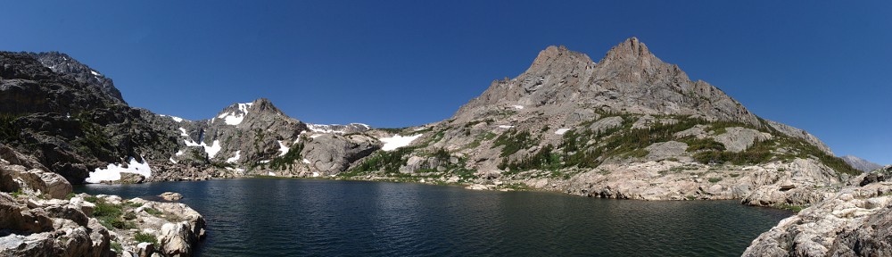
Standing in the parking lot it struck me as a sort of no-brainer of a hike. I’ve said many times, and my history proves, that I prefer hiking to alpine lakes over hiking to the tops of mountains. When you’re standing on the top of a mountain, there is a lot of scenery around you, but it’s all miles away. At a lake, listening to the water lap the rocks at your feet, the beauty of the place is much more immediate: up close and personal.
To now, I’ve only done two 14ers: Longs and Quandary. There is a short list of others I’d like to “conquer”, if that’s not too dramatic a word. There are two main considerations. First, I’m not a big fan of exposure, so I’ll only consider routes that are Class 1 or Class 2. Second, for the most part, I’m limited to trailheads that I can reach in the Lotus. Both of these conditions are met here. So, what am I waiting for?
Now a side note: how are Colorado 14er’s counted? There are 58 peaks in the state that top out over 14,000′. But to be “ranked”, a peak must rise at least 300 feet above the saddle that connects it to the nearest 14er peak. There are five such peaks. Mount Bierstadt is the 38th highest of the 53 ranked 14ers. If you ignored the “300 foot saddle” rule, it would be 40th of 58.
Wednesday, October 7
This trail is one of the busiest of the summer 14er routes, so I was a bit concerned with getting a parking spot. On our visit last week, both parking lots were full and most of us parked alongside the road. That was okay for a short break but wouldn’t work at all for a six or seven hour hike. I decided to leave the house at six, arriving at the trailhead by 7:30 or so. If the lower lot was full, the upper lot would most likely still have spots.
There were still several spots in the lower lot when I arrived. One of the advantages of being here on an October weekday.
I put boots on the trail at 7:32. The first order of business is to descend a couple of hundred feet and cross a broad valley (if that word can be properly used in this geography) to reach the point where the trail actually begins the climb to the summit. This broad “valley” features several hundred acres of my hiking nemesis: willow.

To be fair, my detestation of willow manifests when I’m off-trail. If there’s no game trail through it, it’s best to go around. If you decide to cross a patch of willow, there’s no telling how much effort will be required to get through it. Here, there’s a nice trail through the stuff. Construction of the trail includes hundreds of yards of boardwalk, and the trail looks to be regularly maintained by trimming the plants that border the trail.

In these days of pandemic, I couldn’t help but notice that this boardwalk is only three feet wide. In the photograph, we can see less than half the length of this section. The hikers in the distance are on it. If you come across oncoming traffic, there’s no way to get six feet from them without jumping off the boardwalk. In places, the walk is a couple of feet off the ground. It’s nice and dry this time of year, but stepping off the boardwalk when things are still green means stepping into a marsh.
And with the willow growing almost six feet high, it’s next to impossible to see other hikers until you’re nearly on top of them.
In the willow where no boardwalk is required, it’s somewhat easier to distance yourself from other hikers. There are lots of short paths that lead away from the trail. These, judging by the amount of toilet paper on the ground here, are latrines. Keeping in mind that this part of the hike is within a mile of the trailhead, I was surprised at the sheer number of people who, evidently, couldn’t make it back to the toilets at the trailhead. (I’m pretty sure it’s not people who just embarked on their hikes.)
After crossing the willow field, the trail starts to climb. After a while, it gets steeper. But that’s just the steep bit before it gets really steep. Then, near the top, the trail disappears about 250′ of elevation below the summit. The route description at 14ers.com calls this bit “the crux of the route” and the reason it’s rated Class 2.

For much of the way, it’s clear from the trail condition that this route gets tons of traffic. Rather than a trail that’s a couple of feet wide, it’s often three or four times that. In quite a few places, it’s evident how much of the current trail is the “original” trail, with people widening it by walking on either side. Some of the steeper bits have had quite a bit of work done to remedy this. There are significant sections where the trail is a staircase of rocks.

Even with it being an October weekday, and the parking lots not yet full, there was quite a bit of traffic on the trail. I started meeting descending hikers before I had gone halfway. There weren’t that many, and I didn’t keep track. I did keep track, however, of the hikers going my way. A group of three (with a “small” Saint Bernard) passed me in the willows and a solo hiker zipped by me nearer the top. I passed eleven hikers before the “crux”, then four more before I gained the summit. It wasn’t that I was walking any faster than any of them, just that they kept stopping. I paused to take pictures or to drink water, but only stopped for a break once.
At the trailhead, I had estimated that it would take me three hours to reach the summit. I figured I could do the first mile in half an hour, then expected I’d be no faster than a mile an hour after that. Normally, my pace slows considerably when I’m above 11,000′. This whole hike is above that, starting at nearly 11,700′. I made it a point to set a slow pace that I could hopefully maintain. It looks like I succeeded. I beat my target time, making it in two hours and forty minutes.
The weather was fantastic. There wasn’t a cloud in the skies all day, and the wind was calm, even at the summit. I didn’t notice any wind at all until I was about half way back to the trailhead at about 12:30. And that breeze didn’t last. It was cool in the morning – I wore a thermal undershirt, an Aloha shirt, and a hoodie. I didn’t take the hoodie off until halfway down the trail, and ditched the thermal layer when I got back to the car.
I spent about 45 minutes at the summit, eating my picnic lunch and enjoying a beer. There were never fewer than a dozen people up there. I didn’t see a register or a USGS marker. I asked a few people, none of them saw them either.

I met two young nurses. They sat near me. I noticed that as soon as they sat down, they checked their blood oxygen level with a fingertip pulse oximeter. I asked if I could check mine. It read 93%. They were joking that, at the trailhead, one of them measured only 62%. Evidently, these devices don’t work very well in the cold.
Another young woman was asking if anybody was going to do Mt. Evans from here. She was hiking solo and without a map. In researching this hike, I didn’t look into the combination route that would get you to both summits. But judging by the terrain, there isn’t any route I’d be willing to take. She wisely gave up on her goal. She had recently moved to Colorado and was now living near Aspen. She’d started climbing 14ers this summer, and Bierstadt was her ninth. She really wanted to get a tenth before the snows. I suggested she try Quandary. She thought that was a good idea.

Although the weather was great, the visibility wasn’t. Normally from up at these elevations, you can see great distances. When I was on Quandary, a high school student was pointing out and naming a bunch of 14ers. We could see Pikes Peak, Mt. Evans, Longs Peak, the Maroon Bells, and many others. Today, here on Bierstadt, the only one of these I could see was Mt. Evans, which is, of course, only about a mile away. The haze was fairly uniform, except to the north, where it was thicker, presumably from the Cameron Peak fire.
As is the usual case for me, my hike back to the car wasn’t any faster than my hike up. I stopped several times to take pictures, or to give encouraging words to those on their way to the top. In greeting, people typically ask some variation of “How are you doing?” On a day like today, the answer is “Fantastic!”

This was only my third 14er. Maybe next year I’ll try to get a two-fer: Grays and Torreys.
I’m in for Grays and Torrey’s next year!