Lake Nanita

Friday, July 17

This hike has been on my list for three years. I decided this spring that I would finally go there. I’ve been psyching myself up for this one for about two weeks. This would be the longest hike I’ve ever attempted – 11.1 miles each way according to Foster. I’m struggling to come up with the right words to describe my feelings. I wasn’t exactly anxious (as in filled with anxiety). Intimidated isn’t the right word either.

I hiked a portion of the North Inlet trail a few years ago when I visited Bench Lake. You go nearly seven miles up that trail to Ptarmigan Creek before heading straight up the slope. Those first seven miles are fairly mellow – you gain only about a thousand feet of elevation. The last few miles to Lakes Nokoni and Nanita are steeper, but the net climb for the eleven miles is only about 2400′.

So even though it’s quite a long hike I expected to be able to make good time. My plan was to arrive at the trailhead by seven and I guessed I could make it to Nanita in five hours. Allow an hour of lounging at the lakes and I should be back to the car by six. The drive to the trailhead is a bit over two hours (I-70 and Berthoud Pass) and the trip home another two and a half hours (over Trail Ridge Road) and it would be a very full day – leave the house before five and return at eight thirty. That was the plan, anyway.

I was out the door at 4:30. Traffic was very light and I made good time, jetting over Berthoud Pass. The sun was beginning to light the sky; the mountains to the north were still in silhouette but the wispy banners of clouds above them were lit pink and periwinkle. It was still fairly chilly and I had the heater on. The Fraser valley was blanketed with a layer of ground fog.

I made the trailhead by 6:30 and was on the trail at 6:40. It was cool enough I could have worn a light jacket but I expected to work into a lather fairly quickly. The first mile or so is more a dirt road than a trail – this provides access to a private cabin that’s on Park land. I started working the math in my head. If I manage the first three miles in an hour (a very quick pace for hiking), I would only need to average two miles an hour for the rest of the hike to maintain my schedule. I couldn’t help but recall than I failed to maintain that rate on my last three hikes.

I passed Cascade Falls in exactly an hour, and was at Big Pool in ninety minutes. I was thinking that Big Pool was five miles in, but that couldn’t be right. That would mean I was averaging well over three miles per hour. (Big Pool is 4.8 miles from the trailhead.) After two and a quarter hours I crossed Ptarmigan Creek. I was making very good time. The trail was every bit as easy as I remembered it.

My hike to Bench Lake was not the most pleasant hike. All was going well until I began my descent from the lake. I have difficulty with steep descents and this one was no exception. At my moment of greatest unease, one of my water bottles came out of its pocket and tumbled out of sight, lost. Of course it was the full bottle and not the half full one. So I had to manage my water on a warm day. Then, back on the trail, my ankle started to hurt. I thought perhaps I had an insect or spider bite. It was swollen and red, but I hadn’t twisted it. So the hike out was warm, thirsty, and somewhat painful.

But that was then.

Passing Ptarmigan Creek I was finally on new trail. From here to the Lake Nanita trail spur the trail remains fairly flat. It’s about a mile from Ptarmigan Creek to the junction. From there the trail descends a bit to cross the stream at North Inlet Falls. It is here that the (modest) climb to the lakes begins.

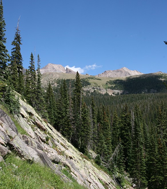
After about another mile the trail begins a series of widely spaced switchbacks. The slope is quite steep but the trail makes the ascent fairly painless. Up to this point, the hike has been through forest or alongside meadows and featured no views to speak of. About three quarters of a mile before Lake Nokoni, the trail traverses the top of this steep slope and the trees have thinned out considerably, opening the rich vistas of the Continental Divide to the east. Below lies the upper North Inlet valley, one of the more remote areas of the park.

It’s easy to concentrate on the majestic views to the east and overlook the profusion of wildflowers on both sides of the trail.

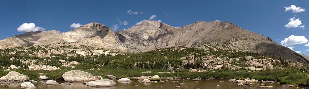
Ptarmigan Mountain pops into view at Nokoni Lake. The trail runs alongside a large slab of rock ten or fifteen feet high. On the other side of this rock lies Nokoni. According to the map, I figured it would be a bit farther away, but it’s right there. The lake is bigger than I expected; it’s a substantial body of water.

Lake Nanita is another 1.1 miles along. The trail crosses a saddle between Ptarmigan Mountain and point 11218. It zig-zags up the slope, mostly clear of trees, with a nice view of Nokoni below. Here I noticed it was a bit breezy. It is exposed here, and the wind gets an unobstructed run across the lake. The tree tops were swaying six or eight feet.

This is the last two hundred feet of climbing, reaching perhaps 11,050′ of elevation. Both Nanita and Nokoni are just below 10,800′. On the other side of this saddle, the trail descends alongside an open meadow and affords an unobstructed view of the western face of Ptarmigan Mountain. It is the better part of a thousand feet straight up. On the topo map you can’t make out the intervals – it’s a solid brown bar.

Unlike the other side of the saddle, where Nokoni was on full display, here you get only glimpses of Nanita. Only upon arriving at the shores of the lake do you get a good view. Foster says, “Lake Nanita is undoubtedly one of the most beautiful tarns in RMNP.” It is difficult to argue otherwise, but it must be noted that there are many lakes in the area that would easily feature on the list of “most beautiful”.

Lake Nanita, too, is a large lake. It’s bigger than Nokoni. I’m left wondering just how many lakes in the park are bigger. That would be a short list.

It took me four hours forty minutes to arrive here from the trailhead. I exceeded my expectations, and that included a ten minute break for a snack part way up the hill to Nokoni.

I plopped myself down on a rock and tucked in to my lunch. I didn’t bring the tripod, as the mount is broken, but considered making a time lapse by setting the camera on a rock. Unfortunately, the shutter timer is in the tripod’s carrying case, so that was a no go. It was a moot point anyway – the sky was absolutely cloudless. I was about 40 minutes ahead of schedule, and it’s typical that clouds don’t feature in the skies until about noon.

I sat there for an hour, enjoying my lunch and watching the world go by. A large bird (an eagle? too far away to identify) soared over the south end of the lake for a while. Fish were active within a few yards of my rock.

The sky was so clear that jets weren’t leaving contrails. A four engine jet flew over, each engine leaving a trail only for a couple of degrees of arc; the plane like the tip of a white spear. It was on a path that would take it between two of the spires of Ptarmigan Towers; it might make an interesting picture. I fumbled the lens cap when I went to take it off. I grabbed for it as it fell, missed it twice before it landed and bounced off the rock, down four feet into the lake. It was lying under four inches of water, but well out of reach. I missed the shot and lost the cap.

I did manage to find a way to clamber down and get it. It required hanging on to the branch of a bush. Had that branch broken, I’d have fallen into the water and been awarded the trifecta: cold, wet, and miserable. The retrieval was successful; a small drama.

Clouds began bubbling up at noon. I was packed up on on the trail by 12:20. After an hour of inertia, I was glad the climb up the saddle between the lakes was not so steep on this side. Once I had sight of Lake Nokoni, I knew that it was all downhill from here. Looking at the hillside above the north shore of Nokoni I could see a trail. This would be the route to Pettingell Lake on the other side of the ridge. Pettingell is the same distance from Nokoni as Nanita, and the route looks to be clear of trees so it shouldn’t be much more difficult than Nanita. It should be doable.

Back at Nokoni Lake I chatted with a group of four. They were the first people I’d seen since about 9:15. I asked if they were going to Nanita. “We were just there.” They must have been very quiet, as I never saw nor heard them, and I sat right where the trail dumps you on the shore of the lake.

I took my time over the next section of trail, where there were nice vistas to the east, taking in the view before rejoining the forest. After this it wasn’t long before I began encountering more hikers. Several folks asked me where I was staying. I was the only day-tripper out there.

I stopped just above North Inlet Falls, refilled my water bottle and ate some fruit. I stopped on the bridge to snap a photo of the falls. I never get a falls picture I like, but I’ll keep trying. At this moment it started to sprinkle. I was standing in bright sunshine but a gray cloud was immediately to the west, with blue skies beyond.

It didn’t look like it would rain hard or for long. I have a poncho, of course, but I didn’t want to mess with it for sprinkles. The cloud was small, and we were moving in opposite directions. I could manage a few drops. About a mile later it was no longer a light sprinkle, and the clouds looked distinctly bigger. Most of the oncoming hikers had donned their rain gear. At Ptarmigan Creek I put the poncho on. A minute later I was thinking it was the right choice – the rain was now mixed with graupel. Another minute later it stopped.

I took another break at Big Pool. Ate more fruit and put the poncho away. It had taken me ninety minutes to get here in the morning; even though I’d been hiking for nearly eight of the last nine hours, I felt pretty good. It was easily twenty degrees cooler in the morning, and I was fresh then, but I felt like I could match that time. I did.

I’ve never hiked so far before, but I’ve certainly done more strenuous hikes. Clearly, it’s all about the elevation gain. But I’m still a little amazed I hiked over twenty two miles in a day.

Chasm Lake

Saturday, July 11

I just about had myself talked into trying my longest hike ever – Lake Nanita. It’s over eleven miles each way and I should be able to bag three new lakes. But that will have to wait. Last Saturday we had lunch with Bob in Loveland and I managed to leave my credit card there. The place is an hour drive away, so if I was to just run up there some evening it would be a two hour trip. Instead, Genae suggested I swing by to get my credit card after a hike. That means an east side hike. Lake Nanita is on the west side.

It was about Wednesday when I decided to visit Chasm Lake. It’s much like the last two hikes – about five miles each way and about a 2400′ climb. My only question was how early I would need to arrive at the trailhead to get a parking space. Once the parking lot fills up, people start parking along the road. But that basically means parking in a ditch, so that’s out. If I was smart, I’d have a backup plan.

I left the house at six with no backup plan. I arrived at the trailhead by a quarter to eight. There were thirty or forty cars parked along the side of the road. Not good. I could have turned around as soon as I hit the parking lot but decided to go all the way to the southern end anyway. At that end of the lot I thought I found an empty spot, but there was a sign there, “No Parking” with an arrow to the right. On the fence at the end was another no parking sign, arrows pointing both ways. On the other fence, on the right side, another no parking sign, with an arrow to the left.

That sign was maybe ten feet from the end. At the other end of the fence, a giant SUV had parallel parked. Behind him there was room for four or five more cars. Why was nobody parked there? The sign clearly only prohibits parking at the end. So I arrived late and scored a parking space anyway.

I put on my boots, strapped on the fanny pack, tripod, and camera and looked for a ranger. I asked if it was okay to park there and described the signs. It was his second shift on the job and didn’t know. He found the other ranger there who said “Fred says it’s okay to park there but Bill says it’s not.” I told him I believed the sign instead of Bill and started up the mountain.

Although this was only my second trip to Chasm Lake, I’ve been on the trail here many times. From the trailhead to somewhat above treeline, there’s not much to see. Above treeline you get a nice view of Twin Sisters and the prominent landslide from the 2013 floods. Once you can see the summit of Longs, it dominates the view to the west.

For me, the view doesn’t really get interesting until you take the trail spur to Chasm Lake. Here you crest Mills Moraine and get the first good look at the giant bowl formed by Mt. Meeker, Longs Peak, and Mount Lady Washington directly ahead. The granite walls of Mt. Meeker form giant amphitheaters two thousand feet high. Below lies the valley of the Roaring Fork – Peacock Pool and Columbine Falls. (Yes, “Roaring Fork” seems to be a common name – I hiked along a different Roaring Fork last week.)

Two landslides from the September, 2013 flooding.

In September of 2013, every stream in the area flooded. Somehow, highway 7 didn’t get washed out. It was a near thing where the road crosses Cabin Creek, at Camp St. Malo. The embankment there caused debris to pile up badly. I don’t know that the Roaring Fork presented a problem near the highway, but here above treeline there were two “small” landslides that deposited alluvial fans on the high valley floor. These landslides are narrow, but something on the order of 500′ high.

My first visit to Chasm Lake was a week later in July. The trail crossed a very steep snow slope. Because Longs has gotten so much late spring snow, I figured there was a good chance of seeing snow there again. I brought my microspikes for just such an occasion, but they were not necessary. The little patch of snow today was only two feet across.

Same view as the flooded section.

On the way up, my gaze was focused on the slow above the trail. I was a bit disappointed that there weren’t many columbines there; I recalled there being many more. On the way back I was paying more attention. The slope below the trail is where the action is. This is the largest field of columbines I’ve ever seen. I paused several times through here on the hike out just to drink in all the sights.

Above Columbine Falls the terrain flattens out before dumping you at the base of a two hundred foot scramble up to the bench holding the lake.

Given the small size of the parking lot and the number of people who attempt to summit the mountain, I’m surprised at how many people are here at the lake. There were dozens of hikers on the spur trail, many more already at the lake, and a number of climbers on the various rock faces. A group of climbers were working their way up the sheer wall to my left; I could hear them calling out to each other as they worked their way up. I should have brought the telephoto lens.

When setting up the camera for the time lapse, I saw that the piece that mounts on the base of the camera is broken. That’s why the last few videos have been jerky – even a slight breeze moves the camera even though the tripod is secure. Oh well.

On the hike out I chatted with several hikers who tried to summit. One group hiked to the boulder field last night. They got there at 9:30 in total darkness and had lost the route. While setting up camp, it began to rain and hail. They got fairly wet and had a less than comfortable night. In the morning they went to the keyhole and decided it was too icy for them to go any farther. I told them I’d only summited once but made the keyhole four times. I never attempted that hike before August.

Hiking out, there was a steady stream of people on their way up. It was far too late in the day for day trippers; they all were planning a night on the mountain. I kept wondering where everybody parks. When I drove away, the answer was clear: now cars were parked alongside the road about half the way to CO 7. Folks arriving late (after 6am?) have an extra half mile (or more) added to their hikes.

I have no plans on summiting Longs Peak again, but I may hike to the keyhole again. The views from there are fantastic. Another possibility is climbing Mount Lady Washington. It’s about a thousand feet lower than Longs and not nearly as treacherous.

Timber Lake

I’ve been aching to hike to lakes I haven’t been to yet. It’s been a long time since I bagged a new lake. No, that’s wrong. On the contrary, it was as recent as October, and half my hikes last year were new. Is going to new places getting to be an obsession for me? “My name is Dave, and I’m an addict.”

Unfortunately, my hunger for bagging another lake is getting harder to sate. I’ve picked all the low hanging fruit and to get to new lakes I have to go farther afield. The remaining ones are farther away, with more bushwhacking, and longer drives to the trailheads. This year I’m planning an 18 mile hike and a 22 mile hike. But it’s too early to try either of those; there is still too much snow on the ground for me to attempt either. If I can’t have a new item from the menu, what haven’t I had for a while?

After giving the question some thought I decided on Timber Lake. I was there once before, thirty odd years ago with my brother. Just that one visit, half a lifetime ago, and I somehow didn’t take a camera. It’s the only lake I’ve visited only once and last visited more than six years ago. This lake will look about as new to me as one I haven’t been to.

Foster lists the hike to to Timber Lake at 5.0 miles and a 2,000 foot climb. The sign at the trailhead indicates 5.3 miles, and from the topo maps it appears closer to 2,100′. Either way, it’s a greater than average climb for a five mile hike.

It’s a west side hike, the last trailhead before the switchbacks on Trail Ridge Road. I figured if I hit the trail by nine I could be at the lake easily by noon, so I didn’t need to hit the road too early. I made a leisurely start, leaving the house a few minutes before seven. I took my time on the drive; top off and a jacket on, a bit on the cool side at 70mph, but not uncomfortable. It looked to be another beautiful day. As I went farther north, though, it became a bit overcast.

Being a west side hike, I figure two hours to reach the trailhead. I went the speed limit the whole way with the possible exception of Berthoud Pass. And as it’s a few more miles into the park than the other trailheads I didn’t get on the trail until nearly 9:30.

IMG_5035sAt the trailhead there was a notice of a detour on the trail due to a landslide, more damage from the floods of nearly two years ago. I was in this vicinity when it started raining then, traversing the ridge immediately to the north of Timber Lake, to and from the Gorge Lakes. I will never forget that one – above treeline for an eternity with lightning striking on the other side of Trail Ridge Road.

The Timber Lake trail doesn’t start climbing until you’ve gone nearly a mile through a mixed forest of pine and aspen. The trees are widely spaced and the ground is covered with grass. You can hear the cars on Trail Ridge until the trail finds the crease made by Beaver Creek and the rushing water drowns out the noise.

After crossing Beaver Creek the trail starts climbing. There are many trails that will climb 400 feet in a kilometer. (Yes, I know. Mixing my units.) For most improved trails, that’s a typical steep section; you may have one or two of these separated by level or nearly level sections. Here it’s twice that – you climb about 900 feet in the two kilometers after crossing Beaver Creek.

The detour was marked with this tape

The detour was marked with this tape

That’s when you arrive at the detour. On my way to this point I pondered what the damage would look like. I was picturing something like the landslide on Twin Sisters but I decided it wouldn’t be like that. On Twin Sisters you cross the landslide area, you don’t detour around it. On Twin Sisters a couple of switchbacks were washed away; you hike along the trail, then climb straight up the slope until you retain the trail; repeat until above the slide.

So I wasn’t surprised to see that the detour takes us straight up the slope. The footing isn’t great; I bet it’s treacherous when it’s wet. The detour goes straight up the slope gaining another 200 feet before contouring along the slope for a while. At the top there’s one spot where the soil has slipped several inches but is still somewhat held together by roots – the top of the landslide. At this point the detour falls straight down the slope a hundred and fifty feet or so and regains the trail.

Prior to the detour, the trail was pretty much free of roots and rocks making it easy to maintain a steady stride. This eased the steep climb somewhat. After the detour the trail features a more typical number of rocks and roots, slowing my pace a bit. All this time the trail has been rising along the side of the valley, a couple hundred feet above Timber Creek. About four miles in, the stream has climbed to meet the trail.

The trail rises steeply again, another two hundred feet in a series of switchbacks, before depositing us at the base of a high, dog-leg valley. The final mile and a quarter to Timber Lake only climbs another 400 feet, skirting the north side of wide open meadows. Timber Creek meanders here in places. But, to me, “meander” connotes slow. The water here is not slow.

The lake is about three times longer than it is wide, and lies more or less north-south in its valley. I arrived at the lake a few minutes before noon. On the way up, I encountered a half dozen or so hikers who were going down but saw no others going my way. I figured I’d stay about an hour and guessed that a handful of other hikers would arrive during that time. I want to maximize my personal space, so I made my way along the western shore to the north end.

The clouds looked to be more dramatic to the south over the mountains, but I didn’t want to shoot directly into the sun. I set the camera up facing the lake’s outlet and the valley beyond. A few feet above the south west shore of Timber Lake is a shallow pond. It has a nice view; I waved “hello” to a pair of hikers who were there enjoying it. By the time I packed up, three other pairs of hikers had spread out on the north east side of Timber Lake where the trail deposited them.

After eating my lunch I watched a large bird soar high above me. It was too far away to be sure, but it was a big bird so I’m guessing an Eagle. He was expending very little energy, gliding back and forth high about the ridge to my east. It amazes me that they can see their prey from such a height.

I began my hike out by continuing around the lake to the eastern shore. Circumnavigating the lake is fairly easy; no trees to speak of, and very little willow. There is some talus at the southern end, but it’s mostly covered with snow right now. The portions that weren’t snow covered were like saturates sponges. It was this way all the way around the lake. Right now, it would be misleading to identify the inlet for Timber Lake. There are a number of trickles that will remain when the snow is all gone, but until then the entire shoreline feeds the lake.

On the way down I decided I’d investigate the landslide area. You’re not supposed to continue down the trail past the detour but curiosity overcame me. By now I was thinking perhaps it would be more like where the Lawn Lake flood undercut that trail. That would certainly call for a detour. There’s a traffic cone block the trail. A short distance beyond it I arrived at the landslide area.

It wasn’t nearly as dramatic as I had envisioned. If I didn’t know it was a landslide, it might have taken me a minute to figure it out. There’s no view; it’s in the middle of forest and it’s not at all like Twin Sisters or Roaring River. Nothing has been washed away. The trees and bushes and grass is still there, but the trees are mostly uprooted, lying at odd angles. The ground didn’t wash away in the flood, it just lost cohesion and slid a short way downhill.

IMG_6364sThere is a small stream here, if you want to call it that. What channel may have existed before isn’t there any more, and the water has spread itself out – over and among and through. What might it take to make things slip some more? It’s hard to say how wide the slide is – twenty or thirty feet perhaps. But I wouldn’t want to be on it were it to let go. This one is tiny compared to the landslides that have been in the news in recent years, but think of the results if this thing let go. It’s about five hundred feet from the the top of the slide down to Timber Creek.

Managing the detour on the way out was not fun. but it was all downhill after that. Between refilling my water supply, the side trip to see the landslide, and chatting with a group from Oregon it took me a half hour longer on the way out than the way in. I was back to the car by four.

I used the app for the Fitbit on the way up. It drained my phone battery to 32% in the two and a half hours it took to reach the lake. At the lake, I put the phone on airplane mode and when I powered it up back at the car it magically was back to 39% charged. Odd. But clearly I won’t be able to use the app on any hikes longer than three hours. (I have a charger in the car, so it was 100% when I hit the trail.)

I would like to use the app another time or two to get a better sense of how well the wristband measures distance. The app, using GPS, said the hike up was 5.6 miles. That compares well to the 5.3 miles indicated on the sign plus going to the far end of the lake. It was just short of fourteen thousand steps. The wristband game me a distance of 7.1 miles on the way out. That was 14,825 steps, so using the same number of steps per mile as the ascent would put it at more like 5.95 miles.

It credited me with climbing 283 flights of stairs. Around the house, it tends to undercount stairs slightly. They count a ten foot rise as a flight, so that 283 isn’t far off. Net elevation gain to the lake would be something like 210 flights. Every trail has its ups and downs. Throw in the detour and 283 sounds reasonable.

The Fitbit says I burned about 1,800 calories on the way up, another 1,700 on the way down, and a total for the day of nearly 5,900. Typically it shows me burning about 2,600 a day.

As to my heart rate, it breaks my activity into three categories: fat burning, cardio, and peak. They determine these by calculating max heart rate as 220 minus my age. Fat burning is more than 50% of max, cardio is more than 70% of max, and peak is more than 85% of max which for me is about 140. It recorded me in the peak category for 70 minutes on the way up and 15 minutes on the way down. I was in the cardio zone 74 and 126 minutes, and fat burning 15 and 37 minutes.

Okay, enough of that.

By the time I was back to the car, the weather was starting to turn. I heard thunder rumble once just before reaching the car and the clouds over Trail Ridge looked a bit threatening. I elected to leave the top on the car for the drive home.

Traffic on Trail Ridge was sometimes painfully slow. A large herd of elk was grazing right next to the road near the lava cliffs so everybody slowed to a walk. I saw a few lightning strikes over the CCY area but only got sprinkled on. It took an hour to get from the parking lot to the eastern gates of the park.  From Estes Park to Lyons we went nearly the speed limit, and sped up again between Lyons and Boulder. Then I ran into a jam – they were carrying the torch for the Special Olympics. I caught them between Jay Road and the Diagonal. That was another ten or fifteen minutes.

All in all, not a bad way to spend the day.

Lake Helene

I’ve developed a real appreciation for Lake Helene. It only recently made it on to my radar. I had hiked from Bear Lake to Fern Lake several times before venturing the couple hundred yards off the trail. The hike is a bit on the short side for me so I’ve been doing it either in winter or late spring, most recently last Sunday.

Jerry and I hiked it last year, a bit earlier in June. We hiked over quite a bit of snow, from not much after the Flattop trail junction all the way to the lake. This time there was not as much snow in spite of the cooler and wetter May. But I get ahead of myself.

As it’s a shorter hike, I didn’t need to get up at the crack of dawn. I left the house around seven and stopped in Boulder for breakfast. I arrived at the Bear Lake parking lot at about a quarter to nine. I was surprised none of the signs suggested I park at the shuttle parking lot. It was a near thing. I snagged one of the last few parking places in time to hear the rangers “call it” – the parking lot was full.

The forecast for Denver was a pleasant but warm day with a high in the mid-90’s. I was expecting the usual brilliant blue skies, but it’s been more humid than normal so visibility wasn’t as good as normal. Perhaps we’re also getting some smoke from the forest fires in California. Other than the haze, though, it was fairly clear.

I wanted to use the Fitbit to log the hike, but the Android app was wonky again so I just pushed the button on the wristband. I’d try the app again for the return trip. I had no intention of using it both directions, as my battery life has been poor lately and I suspect the Fitbit app makes it even worse.

IMG_5030_stitch_crop_resize

Notchtop over Lake Helene

I arrived at Lake Helene a bit after ten and looked for a nice sunny spot to sit and watch the world go by. I made my way to a peninsula of talus surrounded by a sea of snow that stretched about a hundred yards in all directions. Mid-90’s in Denver and here I am, sitting in the pleasantly cool sun on a rock in the snow.

I set up the camera facing down the valley to the north and surveyed the sky. Although the mornings are often cloudless here beneath the divide, it’s typical to see clouds form by eleven or noon. You don’t need time lapse to see them move; they’re generally quite boisterous. Today, though, it was just a thin veil of high clouds with little apparent motion. That’s okay; variety is a good thing.

I spent about two hours not doing much. The snow is melting everywhere around me, just about everywhere I can see. The rocks on Notchtop are streaked dark with water. Lake Helene is brimming at its banks. The falls are too far away to hear, but there is a slight breeze whispering through the pines. Occasional gusts kicked up, painting ripples on the surface of the lake.

Being that there is no official trail to Lake Helene it doesn’t see many visitors. It’s obvious people come here; there is a faint trail and I found footprints in the snow. At this time there are probably fifty people at Emerald Lake, and on the trail there you’re never out of sight or ear-shot of other hikers. Here, I had the illusion of solitude. While I was there, a couple of hikers appeared at the outlet but they were far enough away I never heard them and between here and the Flattop trail junction I met fewer than a dozen other hikers.

According to the Fitbit app, it’s three and a quarter miles. The bracelet comes up with 3.8 miles, but it’s not using GPS. I suspect the shorter distance is more correct. Comparing the data in the two logs, I see pretty much what I’d expect. It took me fifteen minutes longer on the way up than the way back, and I was working harder, burning about 30% more calories.

Back at Bear Lake there was a steady stream of cars arriving at the parking lot. I guess most of these folks figured the signs saying the parking lot was full aren’t intended for them. Strangely, nobody waited for me to back out of my spot. The last guy to pass me waved me by. “Did you just leave that spot?” He thought he might back up and snag that spot, but he never stood a chance. Probably took me 10 minutes to get out of the parking lot. Very crowded.

On the way out of the park, the signs said all the parking lots were full and visitors should try again after 4pm. I’ve never seen any indication that all the parking lots were full before. I don’t recall seeing the shuttle parking lot more than half full. Busy day.

Emerald Lake

Sunday, May 31

The last weekend in May is my traditional jumping off point for the summer hiking season. Following tradition, I visited Emerald Lake.

As it’s a very short hike, I could enjoy a lazy morning. I left the house just after nine and had a pleasant drive in spite of the expected heavy traffic. Before I reached Boulder I realized I forgot to bring the spikes. I never had spikes until a few years ago, so I knew I’d have no problem getting to Emerald, but I’m much more comfortable hiking on snow when I have some traction. And it looks like Longs Peak has more snow now than is typical for this time of year – heck, more than is typical for any time of year – and after a very wet and cool May I was expecting to see more snow at Bear Lake than usual.

I arrived at the Bear Lake parking lot at about 10:45, late enough that I had to park near the bottom of the parking lot. There wasn’t as much snow at Bear Lake as I was expecting; clearly what’s been falling in recent weeks has been melting pretty quickly.

I recently bought a Fitbit Charge HR and this hike was the “shakedown cruise” for it. I played around with it on the Black Hills trip and for the Bolder Boulder, but the Android app crashed and I didn’t collect any useful data. I can use it with or without the phone app. If I don’t use the phone, it collects steps taken, flights of stairs climbed (1 for each 10′ gained), my heart rate, and exercise duration. Using the phone as well, I get a map of my hike. My concern is, if I use the phone, how long will the battery last?

I launched the app at 10:52, right at the car, and started walking. I followed the summer route as there wasn’t enough snow to take the winter route. According to the Fitbit, it was 1.82 miles from the car to Emerald Lake. It took me 48 minutes and I gained 818 feet of elevation.

fitbit_map

One of the reasons I wanted this particular model of Fitbit is to collect a log of my heart rate. I’ve talked to people using older ones, and you need to use a chest strap to get a log of your heart rate, or stop every now and then and query the device to get your current pulse. Here’s what my heart did on this short hike:

fitbit_heartThis was just the hike to the lake. I stopped the app there and restarted it for the return trip. Oddly, I had a higher peak heart rate going down than I did going up. I don’t expect to get similar results on my much longer and more strenuous hikes. Unfortunately, when I got back to the car I managed to plug the phone into the charger without noting how low the battery was, so I still have no idea how well it will work for an all-day hike. I’m guessing I’ll be able to use the app on the hike to where ever I’m going, and not use the app on the way out.

There were fewer hikers than I was expecting. I guess the snow had most of them turning around at Nymph Lake. I did overhear a few amusing snippets of conversation. Near Dream Lake: “Where does all the water come from? Snow melt?” Keep in mind, they hiked half the way here over snow. At Emerald Lake as I was leaving, a young couple arrived, looked around for a few seconds, took a picture to prove they’d been there, and turned around to leave. The young woman calls out to a friend, not yet to the lake, “Hardly worth the trouble, it’s not very scenic.” I have several complaints about hiking to Emerald Lake but lack of scenery isn’t one of them.

I had the SLR up and running for the time lapse by 11:52. Readers of the Black Hills posts will recall that the GoPro was a casualty of that trip, so I only had the one camera. I managed to forget to put the lens hood on it, so when it started sprinkling I stopped and packed up as the lens would get wet right away. This turned out to be a good thing, as the graupel started falling almost immediately.

I beat the squall to Dream Lake and figured I’d set up the camera to continue the time lapse. Unfortunately, I ran into some unknown technical difficulty. The timer wasn’t working. It was counting down properly: “0:02… 0:01…” but no shutter release. Very frustrating. I reset it several times to no avail and by the time I gave up, the graupel started falling here. I had planned to snack on my berries while the camera ran for a while, but so it goes.

IMG_2698sThere’s a nice open view of Glacier Gorge and the Longs Peak complex from the trail below Dream Lake, so I stopped there and ate my blackberries and raspberries. There were squalls over Longs, just as when I paused here on the way up. Very scenic. The weather didn’t follow me past Dream Lake – from my rock with a view to the car, no more precipitation.

I had a lazy drive down the mountain in an unbroken string of traffic from Estes to Lyons.

The time lapse is a bit on the short side this time, but so it goes.

Lake Haiyaha

Saturday, March 7

Some of the folks on the RMNP forum get together every year for a Stomp. I forgot all about it last year, and the year before Jerry and I made it for the pizza dinner but never got to the lake. So this was my first Stomp.

I’m not a big fan of snowshoes. I generally only go on commonly traveled paths in the snow so I can get by with the microspikes. Our route to Haiyaha is off-trail, though, so I definitely needed the floatation the snowshoes provide. I took poles, too. I don’t use trek poles when hiking but figured they might be good with the snowshoes, but won’t again.

This was only my second winter hike to Haiyaha. The first time, I took the summer route. I won’t go that way again in snow. There are a couple places where you traverse steep snow and I’m not a big fan. Ed’s way is a much nicer route. By the time I hiked out, it had been pretty well traveled. I think I could find my way again, now that I’ve been that way.

With the weather the way it’s been lately, I figured the road to Bear Lake would be snowpacked and icy so I arranged to drive Genae’s car, stranding her at home for the day. But Friday was clear and warm – bright sunshine, brilliant blue cloudless skies all day. It was nearly 70 here at the house and the snow almost completely melted from the pavement in the cul-de-sac. I decided to take the Lotus.

Up at 5:30, out the door a few minutes before 6:00. Grab a breakfast sandwich at Burger King in Boulder and head up the canyon. Coming down Pole Hill into Estes, the Mummy range blanketed in brilliant white snow, the sky above the deepest blue, and again not a cloud in the sky, not even contrails.

I took the “shortcut” by the hospital out of habit. It avoids the traffic through the village, but that’s not a concern in winter. I also tend to go up Riverside rather than 36. Just a couple hundred yards past the brewery I saw an animal cross the road. It was in shadow, but looked too small for a deer or elk, and might have been gray instead of tan. When I got there, I saw the coyote standing forty feet from the road. When I passed Manor RV park I got a bonus – a flock of about a dozen turkeys crossed the road. (I just learned the group name for turkeys is not a flock. It’s either a rafter or gang, take your pick.)

A sign near the park entrance warned the road was icy and recommended 4WD or AWD. Not a good sign when you’re RWD with bald tires. But as I suspected, the sun did it’s work yesterday and the road was clear all the way to Bear Lake. There were a couple of icy patches where the wind blows snow across the road, but even the parking lot was mostly free of snow.

I connected with the group and after introductions (where I apologized in advance for forgetting nearly everybody’s name), we hit the trail about 8:15. We set a leisurely pace, which suited me just fine. I find snowshoeing much more tiring than hiking. I have to alter my gait so I don’t trip over my own shoes and of course there’s the weight. It doesn’t seem like much, but compounded over thousands of steps it adds up.

Before long we were off the trail. We weren’t exactly blazing a new trail, as we had Ed’s (days old) track to follow, but the track was generally faint and fully blown over in a couple of spots. All in all, though, the going was fairly easy. It’s not a long hike, there are only a couple of sections with much of a grade, and it has pleasant views. I saw no other hikers, although a couple did catch the end of our group just as we got to the lake.

It took us a bit over two hours to make the trip. We went to the igloo and met Ed and the rest of the gang and socialized for a while. A bit after noon, most of the gang left. It was lunch time, though, so I sat on the rock above the igloo and enjoyed the view and my picnic. I didn’t exactly eat and run, but soon said my goodbyes and headed back.

IMG_1738s

The igloo is sheltered by an enormous rock; the floor is about level with the top of the door.

When I hiked to Emerald last month, I was only able to shoot a handful of pictures – the batteries weren’t working well in the cold. This time, I carried them in my pocket to keep them warm. There wasn’t any point in setting the cameras up for time lapse as there were no clouds all day. So the next order of duty was to put the batteries in the camera and check out the ice on the lake.

I’ve been to ten lakes in the park when they’ve been iced over. Lake Haiyaha is unusual. Many of the lakes seem to maintain the same level in winter as summer. At Lake Helene the water level drops a foot or two, but it’s so shallow that the water is quite far from the summer shore. Haiyaha sits next to a large boulder field. Some of the rocks are as big as houses, some as big as cars. When it gets cold it ices up. At the same time, less water flows into the lake than out and the water level drops. Not a foot or two, but eight or ten.

There are a number of large boulders that are fully submerged until the lake drains and they punch through the ice. I wonder how long it must take – it takes a long time to drain a lake and the water drops very gradually. When the ice makes contact with the rock, the pressure will build up slowly but inexorably. As more ice is lifted from the water, the bottom surface of the ice is put under tension. Ice doesn’t handle tension well – I bet it makes quite an interesting sound when cracks.

IMG_1749s

Icy volcanoes

Now, a line of these rocks poke through the ice like glacier shrouded volcanoes. The broken faces of the ice are no longer razor sharp – wind and blowing snow have softened, almost melted, the edges. It’s crystallizing on the top, but under that zone it’s the palest blue glass. Up close you see the bubbles lined up like beads on a curtain. My pictures don’t do it justice.

IMG_1753s

Blue ice

I probably spent half an hour soaking it in.

IMG_1764s

Wind sculpted snow

The hike out was uneventful. I heard voices occasionally but never saw anybody else until I regained the trail. (Again, am I hearing voices, or am I hearing voices?) A few other parties had done round trips on the track by the time I started down, so it was very easy to follow and often well packed. For a while I thought I maybe could do it in spicks instead of snowshoes, but that would have been optimistic.

Back at the car, I considered taking the top off for the drive home. That would have been a bit optimistic, too. And besides, by this time I realized I hadn’t even thought of sunscreen and had burned my face. Oops.

Twin Lakes and Sandbeach Lake

Sunday, October 26

A couple weeks ago I met Gale on the trail to Lawn Lake and we exchanged emails. This week, she asked if she could tag along, if I was planning on a hike on Sunday. Well, I had no plans when she asked but that was easy to remedy.

A couple years ago I followed Foster’s directions in an attempt to find Twin Lakes in Wild Basin. She says “finding these lakes is a bit of an orienteering challenge”. I fell short of that challenge and figured it was about time I made a second attempt. I studied the map for a while, finally suggesting that Gale accompany me on my second assault. Over three or four days, my plan evolved a few times with my final idea being after we visit Twin Lakes, we cross the ridge, bushwhack up to Sandbeach Lake and hike out on that trail.

We met at the Sandbeach Lake trailhead shortly after eight. I left my car there and she drove us to the Thunder Lake trailhead. We put boots on the trail before eight thirty. It was sunny and mostly clear; the only clouds were hanging over the Divide. It was also windy. I think I used the phrase “a bit breezy.” What I really meant was more like “it was savagely windy.” But the hike would be through forest the whole way; the only time I expected to deal with the wind was when we were hanging out at the lakes.

Rather than follow Foster’s directions this time, my plan was to hike up the Thunder Lake trail until we reached about 9800′ elevation, then contour east along the slope to the lakes. I’m generally low tech when I’m hiking. I don’t carry a GPS unit with me. I do carry a smart phone, though. I use a speedometer app when I’m in the car because the car can’t be trusted to tell me how fast I’m going. This app also shows the elevation, which can be handy in cases like this.

Shortly after regaining the main trail after the campground shortcut, we arrived at a couple of switchbacks. The eastern end of one of these was conveniently close to our target elevation so we headed off trail there. As is usual when off trail, we couldn’t go in a straight line. I kept thinking we were going downhill, but every time I checked our elevation we were still on target. It was in here I saw the only wildlife on the hike: I spooked a very large rabbit who made very good speed in spite of his girth.

We weren’t making great time, what with finding the best route past rock outcrops or through dense pockets of trees. But it didn’t take too long to arrive at the larger of the Twin Lakes. This is the westernmost, larger one. These lakes are snow fed, neither has an inlet or outlet stream. They’re pretty shallow and, again, I’ve been to larger unnamed ponds in the park. But the view to the west from this lake was very nice. As expected, the wind was quite strong here. At times the wind gusts were so strong they kicked spray up ten or fifteen feet above the water.

We found a place more or less out of the wind and I set up the SLR to do the time lapse. We sat and ate part of our lunches and watched the world go by for about a half hour. Upon retrieving the camera I saw that I neglected to use my usual settings. There are a number of things I have to change from my usual shooting – turn off auto-focus, turn off stability, set it on full manual and set the proper exposure, configure the timer. And change it from storing raw images with large, fine JPG to a smaller image. This is the first time I’ve managed to forget this part. So I filled the memory card pretty quickly. Oops. I’ve been meaning to buy a bigger card; perhaps this error will be the impetus for me to get it done.

After getting our gear together, we headed the short distance to the other Twin Lake. It’s just a few yards away, and up a few feet of elevation. We passed through a little aspen grove. This one turned out to be perhaps the most interesting aspen grove I’ve walked through. Some beaver had been busy here, gnawing through dozens of trees. Some had been downed, chewed through completely. Others were still works in progress. The wood chips looked fairly fresh; I doubt this work was abandoned, but what do I know?

I didn’t see anything like a beaver lodge in either lake, and there are no streams here. The beaver must be in one of the lakes, though. These were pretty big trees; there was no other possible body of water this lumber could be taken to, unless that beaver has access to a helicopter or something. Which probably means I wouldn’t recognize a beaver lodge if I was standing on it.

There is almost no view at the smaller of the two lakes, so we didn’t dally there long. From here, we headed almost straight up slope. We only needed to gain about two hundred feet to top the ridge. We passed a couple of cairns and came across what I think is a wildlife trail. After topping the ridge, a small unnamed pond was next, just below us. The pond sits, as is common, surrounded by marshy grass. Being nearly November, it was mostly dried out.

Sandbeach Creek feeds this pond. The map also shows a gully a bit to the west of the creek. We found ourselves ascending this gully rather than the creek. The gully is clearly a flowing stream during spring and summer; now it’s dry but verdant, filled with moss covered rocks, darkly green in the shade of the forest. In places, it looks like there is dried mud covering some of the rocks. It’s not mud, but a dried fibrous sheet a couple millimeters thick.

The gully opened into a clearing where we hopped up a pile of rocks about thirty feet high before returning to another mossy section. Here I decided we needed to head a bit more towards the east. “Just over this next rise we’ll find the lake.” It wasn’t the first time I said it, but I was finally correct. We emerged on the shore of Sandbeach Lake just a few yards to the west of the outlet stream.

It was calm here on the lee shore. It was also mostly devoid of an interesting view, so we circled counter clockwise toward the trail. The wind was quite intense on the east side of the lake. And because this used to be a reservoir like Lawn Lake, there aren’t any trees along the shore to provide shelter. We retreated into the forest, found a nice rock to sit on, and ate more of our lunches. I decided not to set up either camera as I figured neither would be able to sit still in this wind. So it goes. It’s unlikely I have enough footage to bother with a video this time.

There were a few other hikers there. We talked to two guys who spent the night there. They had heard there was an alternate route back to the trailhead. I got my map out and showed them a route I considered for this hike. And, as we no longer needed it, I gave them the map.

The hike out was uneventful. The wind seemed to be dying down a bit, and the skies remained clear overhead. Crossing Hunters Creek, I wondered if there was a bridge there that was washed away last September. There are just sawn logs there now. Perhaps I’m just misremembering. We arrived at my car a few minutes before three, still feeling fresh and in agreement that it was a fun hike. The off trail excursion was pleasant and the beaver activity at the lakes was unusual and quite interesting.

On a final note… I regularly wonder how often my car shows up on Instagram or Facebook. People are always taking pictures when I’m at stop lights or in parking lots. This evening, my son found my car on Facebook. It’s a picture taken today, at the trailhead. Too funny.

Lawn Lake

October 11

Wednesday I started thinking about where to hike next. At first I was thinking it might be a good time to try Spectacle Lakes. You either climb steep slabs or climb straight up the stream. This late in the season, that stream will be as dry as ever. Then I searched the message boards for trip reports. The consensus is you should have a hiking partner. So Spectacle Lakes is a no go, for now. Still, I haven’t been up towards Ypsilon Lake in a while so I decided Fay Lakes would be a good destination. I could bag three more lakes on one shot, and it’s not a terribly long hike.

The forecast for Denver was good weather, with a high in the low seventies. It rained Thursday night, snowed above nine thousand feet, or so the weather wonks said. Should be a gorgeous day for a hike.

I arrived at the Lawn Lake trailhead about eight and was kitted up and on the trail a few minutes later. It was a brisk, clear morning. Lots of tourists were already in the park, lining the roads watching the herds of elk. Only a few cars were at the trailhead, though.

About thirty five minutes into the hike, I reached the Ypsilon trail junction. I met the two hikers who hit the trail as I was putting my boots on. “You probably already know the bridge is out.” I didn’t. I scouted it out anyway. There were a couple of logs laid across the water. Old, gray, dead logs. I put a foot on them and they moved under my partial weight. And they were covered with frost. I decided Lawn Lake would be a nice enough place for a picnic, so back I went to the main trail.

IMG_0206sThe trail was undercut in a few places by the flooding last September. A few more short stretches of trail have disappeared into the abyss. Other than that, and the bridge, there really isn’t much damage from last year’s floods.

I caught Gail and Glen a bit farther up the trail. We hiked together for a while, chatting. Before long we started seeing traces of snow on the ground. They stopped for a break and I continued. The snow was deeper after a while; not more than an inch, and not entirely covering the trail. There were some boot prints and after a bit I saw the first animal print.

At first I thought it might be a mountain lion. There was just the one print. A few yards along there were a couple more. Claws prominent with each print, so not a cat. Dogs are not allowed in the park and I don’t think we have wolves. These prints followed the trail for two miles or so, never short cutting the switchbacks, never stepping off the trail.IMG_0209fIt struck me as odd until I thought about it. I’ve run into all sorts of animals using the trails. I met a lame moose on the trail near Verna Lake. He wouldn’t get off the trail, I had so shoo him along. Last spring I met that bear sitting in the middle of the trail. And I can’t count the number of times I’ve seen various sorts of animal pooh. Obviously, animals use the trails too. Trails make travel easier, why wouldn’t animals use them?

Having spotted these nice tracks I began to wonder when the beastie put them down. It had to have been Friday evening. The snow was fairly soft when the prints were made. Many of them were quite well formed. Even at nine thirty the snow on the trail was still quite solid, refrozen overnight. So they had to be put down some time late afternoon or early evening.

I made it to Lawn Lake shortly after eleven. It is clearly no longer summer here at 11,000′. It is clear directly overhead, and to the east. Some gray clouds are sitting on the divide. The wind is shredding the clouds, tearing chunks off and sending them eastward and evaporating them. It happens with such ferocity It doesn’t take a time lapse video to see it.

With it so windy a couple thousand feet overhead, it’s no surprise it’s windy at the lake as well. And there are no trees within a hundred yards of the water. The lake covered a much larger area when it was dammed and even in thirty two years, no trees have filled the void.

Mummy Mtn

I set the cameras up and took refuge on the southeast side of the only large boulder near the outlet. I put the GoPro nearly in the water, right up against the bank and as far out of the wind as possible. I put the SLR on the tripod to the lee side of a rock, but none of the rocks were that big. The camera was still in the breeze. I haven’t looked at the pictures yet, so I don’t know how much the camera moved.

It has always been the case until now that I sat on my rock or log and watched the same sky the cameras were filming. My wind sheltering boulder blocked my sight of everything north and west so I watched mostly to the south. The only gray cloud in the sky was behind me, sitting over the Saddle. Although it was clear overhead, I occasionally had snow fall on me. Not flakes, little pellets. But not quite graupel.

Lawn Lake

It was a bit on the cool side but not bad if you stayed both out of the wind and in the sun. I sat there about forty five minutes, which was long enough for me to be ready to get moving again. Before leaving, I wandered over to the breach in the dam and checked things out. At the other reclaimed reservoirs, there really isn’t much sign that they were ever dammed. At Pear and Bluebird there’s the obvious bathtub ring, but that’s it. Same for Sandbeach. I guess the earthen berm here is too large to bother with.

Heading down the trail I started running into people. I didn’t see Gail and Glen again, but chatted with a couple who said “Are you Dave? We just met Gail and Glen.” The next hikers were headed to Crystal Lakes. I said it was a bit breezy. “Breezy or windy?” They said they didn’t want to fight the wind. I wished them luck; they might get weather in addition to wind.

IMG_1184sOn the way down I couldn’t help but notice how quickly the snow was melting. I’m guessing the snow line raised a thousand feet or so between nine and one. The coyote prints were still there, mixed in with several times as many boot prints as before. I’d been wearing my windbreaker the whole day, finally took it off half way back to the car.

I stopped for a fruit break where I had a nice view of Longs Peak and considered shooting a few more minutes of time lapse, but I didn’t have enough free memory to make it worthwhile. I just need to go out and get a bigger memory card and be done with it.

I made it back to the car before three and headed home. Before leaving the park, I stopped at one of the many overlooks and got a picture of the clouds over the Bear Lake area. When I got back in the car, there was an older guy there admiring it. I said hello, but he just nodded and smiled. I’m guessing he didn’t speak much English.

I keep falling farther behind in putting the videos together. I’d hoped to have the one for Tourmaline Lake done by now. I’m real close, really. So now I “owe” two videos. Stay tuned!

Timetable


Up Down
Trailhead 08:08 AM 02:46 PM
Lawn Lake 11:10 AM 11:55 AM

Tourmaline Lake

September 27, 2014

This is the second time I hike to Tourmaline Lake. Last year I hiked here from the Fern Lake trailhead. This time I started at Bear Lake. It’s a bit shorter this way, and downhill a bit as well between Lake Helene and Odessa Lake.

As seems to be the general case, I got a bit of a late start. It was another free day in the park, and traffic was a bit worse than I was expecting. By the time I got to Bear Lake road, the signs indicated the parking lot was full and visitors should use the park and ride. It’s been a while since I used the shuttle and while the route hasn’t changed, there are more stops than I was used to. It was a few minutes after nine before I hit the trail.

A calm, clear morning

The morning was calm and clear. Expecting a touch of fall in the air, I wore jeans rather than shorts. I wasn’t uncomfortable in jeans, but would have been happier in shorts. So it goes. Getting a bit of a late start, I made an effort to make some good time. It’s about four miles to Odessa Lake and I felt I should be able to cover that ground in two hours and arrive by 11:07. Well, let’s just round that down and target Odessa Lake by 11:00.

The trail was pretty busy. I had a trail runner pass me before I arrived at the junction with the Bierstadt trail. At the Flattop junction, I passed a group of five or six hikers headed to the Fern Lake trailhead. A bit later on, it was a guy with fishing gear and his companion who where headed to Fern Lake. I met many others as well, and most people were going from Bear Lake to Fern Lake trailhead.

Just before reaching Odessa Lake, I ran into the trail runner again. He had made it to Fern Lake and was on his way back. I asked how quick a pace he was able to maintain and he said he was doing eight and a half or nine minute miles. Not bad on a rocky and root crossed trail.

I arrived at Odessa Lake ahead of schedule. By now the sky was no longer cloudless – small puffy white clouds were in action, and contrary to normal were moving roughly east to west. I didn’t even pause at Odessa and headed straight up Tourmaline Creek. At the risk of repeating myself, the route from here is more or less straight up the creek. It’s pretty steep at first, mellows out a bit in the middle, then gets steep again. For the top half of the climb, the creek is mostly invisible but burbling vibrantly under rocks and boulders. With no sign of trail or cairns, just rock hop up the creek. It took me about fifty minutes to get from Odessa to Tourmaline, a climb of 560′ in six tenths of a mile.

Knobtop Mountain and Tourmaline Lake

Tourmaline Lake isn’t much of a lake. I’ve been to several unnamed ponds in the park that are bigger. What it lacks in size it more than makes up in setting. It is surrounded by dramatic rock walls, some with interesting spires. Although it wasn’t windy, it’s clear that high winds are a normal aspect of the place. All the trees around my picnic spot were one-sided, having no branches on their west sides.

While I was eating my lunch I heard somebody yell out. I think whoever it was just wanted to hear their voice echo. I responded with my own yell. A short while later I thought I heard voices quite a bit nearer to me but I never did see anybody. On these off trail hikes in solitude I often think I hear people talking. Sometimes I wonder if it’s a trick of the imagination.

It was a very pleasant day and I enjoyed sitting there by this small lake for the better part of an hour. Ate my sandwich and a plum, and a cookie that was in several pieces, chocolate chips beginning to melt slightly. There was never more than a slight breeze, and no pesky insects. The clouds, unusually, went from east to west.

The outlet stream is fairly flat exiting the cirque, going northeast before making a right turn and tumbling steeply downhill. The flank of Flattop is to the right, with Joe Mills Mtn directly in front. I can’t help but think it wasn’t this steep on the way up, but everything looks steeper to me on the way down. There is much less water flowing now than when I hiked in late June, making for easier hiking.

Before returning to Odessa I refill the water bottle and ponder which way to return. I didn’t give it any thought when I decided to go to Tourmaline, I guess my assumption was that I’d hike back to Bear Lake. I got to thinking that because I was parked at the park and ride rather than Bear Lake, I could hike out to the Fern Lake bus stop instead. Of course, I could have done that even had I parked at Bear Lake. Sure, it’s something like 1.7 miles farther, but it’s all downhill.

I decided to make the one way trip. This would be the third time I’ve done it, but the first adding the spur to Tourmaline. And this time, even with the late start and the extra lake, I’d probably get to the car at about the same time as the other times.

At Fern Lake I chatted again with the fisherman and his wife/girlfriend. They were heading back to Bear Lake. Near Fern Falls I ran into the group I met at the Flattop trail junction. Nearer the Pool, I felt the fire damage wasn’t as dramatic as it was last spring, but there’s a good sized landslide there now as well.

Hiking out from the Pool always seems like drudgery to me, I’m tired, it’s usually warm, the trail is crowded. It always seems to take forever. This time, though, it was over quicker than I expected. I covered the eight tenths of a mile from the trailhead to the bus stop in thirteen minutes, which nearly equals the pace of my walks around home. I felt real good.  Then I nearly dozed off on the (36 minute!) bus ride back to the car.

All in all, a very satisfying hike.

I’m still working on the time lapse. Seems each one takes longer than the previous one.

Box Lake and Eagle Lake

Saturday I hiked to Box Lake and Eagle Lake.

I was hoping to hit the trail by 7:30, but I got out of the house a few minutes late and had to stop for gas in Lyons. I was late enough I had to show my pass at the entrance and the rangers were directing traffic in the parking lot. Again I was parked in a small end spot right next to the trash cans and bathrooms.

“You were here last week, weren’t you?” No, it was three weeks ago. “Yeah, you were parked at the Finch Lake trailhead.” Turns out he used to own an Elise. A red one – he said everybody asked if it was a Ferrari.

He asked where I was headed and told me the bridge at Ouzel Falls is out. It didn’t matter to me; I take the campground shortcut anyway. He then told me a sow with two cubs has been hanging around Thunder Lake.

I wasn’t much behind schedule; hit the trail at 7:45. To get to Box Lake you must first get to Thunder Lake. The distance is 6.2 miles with a climb of only a tad over two thousand feet. The first stretch of trail follows the North St. Vrain. This part is heavily traveled in the afternoon with folks out to see Calypso Cascades. You arrive at the campground shortcut just before the trail crosses the river. The shortcut meets the Thunder Lake trail above the second river crossing and eliminates Calypso Cascades, Ouzel Falls, and six tenths of a mile.

With the exception of the campground shortcut, the trail is generally wide, seldom steep, and often free of rocks and roots, allowing for a faster pace. The next milestone is the junction with the Lion Lake trail. This is about halfway from the shortcut to Thunder Lake. Next are a couple of stream crossings and finally a short descent to the lake. Rather than the usual hitch rack there’s a corral.

Once at Thunder Lake, the idea is to cross the outlet, contour around the eastern buttress of Tanima Peak and ascend a gully to Box Lake. Foster warns “be careful not to get too high on the steep, cliff-ridden slopes.” From Box Lake, climb to the top of the next bench to reach Eagle Lake.

The streams are running quite high for mid-August, and Thunder Lake was spilling into the meadow on its eastern shore in several places. The water flows through the grass in a great swath. It’s possible to cross without going more than ankle deep, but only just.

Once across the outlet, there’s a faint trail. I didn’t spot it at first so I headed around the slope. I quickly found the trail. Long stretches of it aren’t so faint, but it does fade in and out in the grassier parts. I think that without a trail, I doubt I’d have gotten there. For the most part, the trail took the obvious route. But there were times when I’d have gone a different way if there was no trail.

Longs Peak and Mt. Meeker

The route alternates between forest and meadow. The meadows are vibrantly carpeted with blue, yellow, red, and white wildflowers. It was quite breezy at Thunder Lake, but here in the lee of Tanima Peak it is calm. The sun is shining brightly in a brilliant blue sky punctuated with the small, fast moving clouds so common here along the divide.

The trail dips a bit before reaching the gully. Here we climb through meadows bordered by granite. Water burbles down the slope, feeding the prolific flowers. There is a rich insect life here, as well. The mosquitoes were out in force. Every time I stopped I was swarmed by them.

Box Lake

Box Lake sits just over the top of the gulley. While it’s in a nice setting, the surrounding views are not dramatic. Eagle Lake is the true destination on this hike, and it’s just another quarter mile away. Climb another gully to the top of the next bench. Foster warns about “nasty krummholz” but the path I took it wasn’t a problem. There’s an unnamed pond here, bigger than I was expecting. It has a nice view of the valleys to the east. Continuing on over mostly bare rock, it was a simple matter of following cairns in a straight line to my destination.

Unnamed pond

Eagle Lake is fairly large. I sat on a rock above the lake with views of the Continental Divide over the lake to the west and Mt. Meeker and a sliver of Longs to the South. I set up the cameras then broke out my picnic lunch. It never ceases to amaze me how much better food tastes when I’m sitting by an alpine lake.

Eagle Lake

As is usual in these places, it was a bit breezy. I was looking forward to a breeze thinking it would minimize the mosquito situation. Unfortunately, the damn things managed to buzz around my head the whole time I was there. I don’t think I got bitten, but they sure were annoying.

After about forty minutes I started packing up. The weather was still quite nice. With all the moisture we’ve been having lately I was concerned a thunder shower would brew up, but there was never a threatening cloud.

There wasn’t much traffic on the trail in the morning. Near the trailhead I passed a group of six or eight guys loaded down with gear. Three runners passed me about a half hour apart and I chatted with a solo hiker on the shortcut section. On the way down I ran into people as soon as I returned to Thunder Lake.

Just after I passed the spur to the campsite, I encountered another group of heavily laden hikers. They were going to do Mt. Alice tomorrow, via Lake of Many Winds and Boulder-Grand Pass. It wasn’t until a few after we chatted that I realized this was the same group I passed first thing in the morning. Made me feel sort of good. I made it to Thunder Lake in two and a half hours and it took these guys half my age six. Of course, they had heavy packs, were only going as fast as their slowest guy, and for all I know they took a side trip to Lion Lake.

Pilot Mtn and Mount Alice from Thunder Lake

Shortly after talking to them I met another solo hiker refilling his water from a stream. He had hit the trail at five and spent most of the day above treeline. From Lion Lake he summited Mt Alice, Pilot Mtn, and Tanima Peak. Quite an ambitious hike. He probably beat me back to the parking lot by a half hour.

Timetable

 ThereBack
Trailhead07:45 AM04:25 PM
Shortcut (bottom)08:10 AM03:50 PM
Shortcut (top)08:50 AM03:05 PM
Lion Lake trail jct09:20 AM02:30 PM
Thunder Lake10:15 AM01:25 PM
Box Lake11:15 PM12:30 PM
Eagle Lake11:35 PM12:20 PM