Sunday, May 31
The last weekend in May is my traditional jumping off point for the summer hiking season. Following tradition, I visited Emerald Lake.
As it’s a very short hike, I could enjoy a lazy morning. I left the house just after nine and had a pleasant drive in spite of the expected heavy traffic. Before I reached Boulder I realized I forgot to bring the spikes. I never had spikes until a few years ago, so I knew I’d have no problem getting to Emerald, but I’m much more comfortable hiking on snow when I have some traction. And it looks like Longs Peak has more snow now than is typical for this time of year – heck, more than is typical for any time of year – and after a very wet and cool May I was expecting to see more snow at Bear Lake than usual.
I arrived at the Bear Lake parking lot at about 10:45, late enough that I had to park near the bottom of the parking lot. There wasn’t as much snow at Bear Lake as I was expecting; clearly what’s been falling in recent weeks has been melting pretty quickly.
I recently bought a Fitbit Charge HR and this hike was the “shakedown cruise” for it. I played around with it on the Black Hills trip and for the Bolder Boulder, but the Android app crashed and I didn’t collect any useful data. I can use it with or without the phone app. If I don’t use the phone, it collects steps taken, flights of stairs climbed (1 for each 10′ gained), my heart rate, and exercise duration. Using the phone as well, I get a map of my hike. My concern is, if I use the phone, how long will the battery last?
I launched the app at 10:52, right at the car, and started walking. I followed the summer route as there wasn’t enough snow to take the winter route. According to the Fitbit, it was 1.82 miles from the car to Emerald Lake. It took me 48 minutes and I gained 818 feet of elevation.

One of the reasons I wanted this particular model of Fitbit is to collect a log of my heart rate. I’ve talked to people using older ones, and you need to use a chest strap to get a log of your heart rate, or stop every now and then and query the device to get your current pulse. Here’s what my heart did on this short hike:
 This was just the hike to the lake. I stopped the app there and restarted it for the return trip. Oddly, I had a higher peak heart rate going down than I did going up. I don’t expect to get similar results on my much longer and more strenuous hikes. Unfortunately, when I got back to the car I managed to plug the phone into the charger without noting how low the battery was, so I still have no idea how well it will work for an all-day hike. I’m guessing I’ll be able to use the app on the hike to where ever I’m going, and not use the app on the way out.
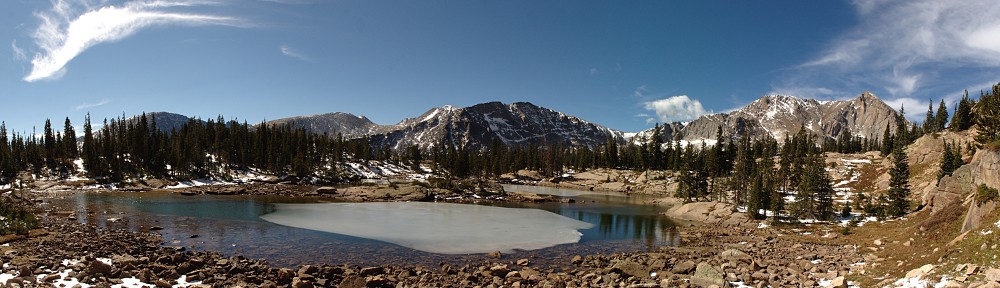
There were fewer hikers than I was expecting. I guess the snow had most of them turning around at Nymph Lake. I did overhear a few amusing snippets of conversation. Near Dream Lake: “Where does all the water come from? Snow melt?” Keep in mind, they hiked half the way here over snow. At Emerald Lake as I was leaving, a young couple arrived, looked around for a few seconds, took a picture to prove they’d been there, and turned around to leave. The young woman calls out to a friend, not yet to the lake, “Hardly worth the trouble, it’s not very scenic.” I have several complaints about hiking to Emerald Lake but lack of scenery isn’t one of them.
I had the SLR up and running for the time lapse by 11:52. Readers of the Black Hills posts will recall that the GoPro was a casualty of that trip, so I only had the one camera. I managed to forget to put the lens hood on it, so when it started sprinkling I stopped and packed up as the lens would get wet right away. This turned out to be a good thing, as the graupel started falling almost immediately.
I beat the squall to Dream Lake and figured I’d set up the camera to continue the time lapse. Unfortunately, I ran into some unknown technical difficulty. The timer wasn’t working. It was counting down properly: “0:02… 0:01…” but no shutter release. Very frustrating. I reset it several times to no avail and by the time I gave up, the graupel started falling here. I had planned to snack on my berries while the camera ran for a while, but so it goes.
 There’s a nice open view of Glacier Gorge and the Longs Peak complex from the trail below Dream Lake, so I stopped there and ate my blackberries and raspberries. There were squalls over Longs, just as when I paused here on the way up. Very scenic. The weather didn’t follow me past Dream Lake – from my rock with a view to the car, no more precipitation.
I had a lazy drive down the mountain in an unbroken string of traffic from Estes to Lyons.
The time lapse is a bit on the short side this time, but so it goes.