Saturday, July 11
I just about had myself talked into trying my longest hike ever – Lake Nanita. It’s over eleven miles each way and I should be able to bag three new lakes. But that will have to wait. Last Saturday we had lunch with Bob in Loveland and I managed to leave my credit card there. The place is an hour drive away, so if I was to just run up there some evening it would be a two hour trip. Instead, Genae suggested I swing by to get my credit card after a hike. That means an east side hike. Lake Nanita is on the west side.
It was about Wednesday when I decided to visit Chasm Lake. It’s much like the last two hikes – about five miles each way and about a 2400′ climb. My only question was how early I would need to arrive at the trailhead to get a parking space. Once the parking lot fills up, people start parking along the road. But that basically means parking in a ditch, so that’s out. If I was smart, I’d have a backup plan.
I left the house at six with no backup plan. I arrived at the trailhead by a quarter to eight. There were thirty or forty cars parked along the side of the road. Not good. I could have turned around as soon as I hit the parking lot but decided to go all the way to the southern end anyway. At that end of the lot I thought I found an empty spot, but there was a sign there, “No Parking” with an arrow to the right. On the fence at the end was another no parking sign, arrows pointing both ways. On the other fence, on the right side, another no parking sign, with an arrow to the left.
That sign was maybe ten feet from the end. At the other end of the fence, a giant SUV had parallel parked. Behind him there was room for four or five more cars. Why was nobody parked there? The sign clearly only prohibits parking at the end. So I arrived late and scored a parking space anyway.
I put on my boots, strapped on the fanny pack, tripod, and camera and looked for a ranger. I asked if it was okay to park there and described the signs. It was his second shift on the job and didn’t know. He found the other ranger there who said “Fred says it’s okay to park there but Bill says it’s not.” I told him I believed the sign instead of Bill and started up the mountain.
Although this was only my second trip to Chasm Lake, I’ve been on the trail here many times. From the trailhead to somewhat above treeline, there’s not much to see. Above treeline you get a nice view of Twin Sisters and the prominent landslide from the 2013 floods. Once you can see the summit of Longs, it dominates the view to the west.
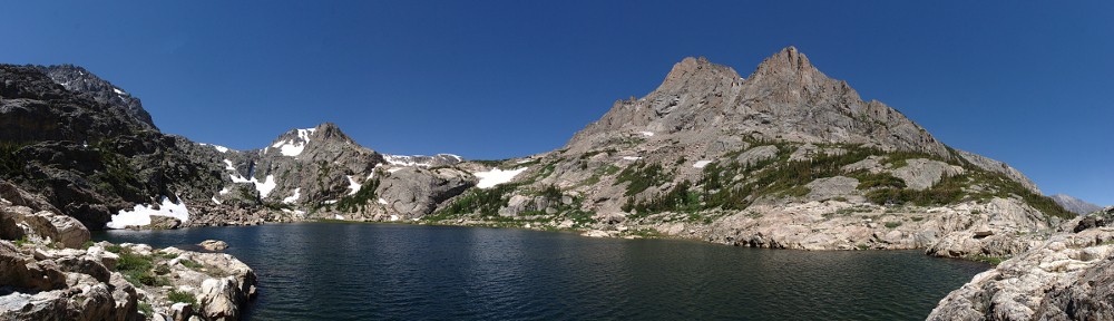
 For me, the view doesn’t really get interesting until you take the trail spur to Chasm Lake. Here you crest Mills Moraine and get the first good look at the giant bowl formed by Mt. Meeker, Longs Peak, and Mount Lady Washington directly ahead. The granite walls of Mt. Meeker form giant amphitheaters two thousand feet high. Below lies the valley of the Roaring Fork – Peacock Pool and Columbine Falls. (Yes, “Roaring Fork” seems to be a common name – I hiked along a different Roaring Fork last week.)

Two landslides from the September, 2013 flooding.
In September of 2013, every stream in the area flooded. Somehow, highway 7 didn’t get washed out. It was a near thing where the road crosses Cabin Creek, at Camp St. Malo. The embankment there caused debris to pile up badly. I don’t know that the Roaring Fork presented a problem near the highway, but here above treeline there were two “small” landslides that deposited alluvial fans on the high valley floor. These landslides are narrow, but something on the order of 500′ high.
My first visit to Chasm Lake was a week later in July. The trail crossed a very steep snow slope. Because Longs has gotten so much late spring snow, I figured there was a good chance of seeing snow there again. I brought my microspikes for just such an occasion, but they were not necessary. The little patch of snow today was only two feet across.

Same view as the flooded section.
On the way up, my gaze was focused on the slow above the trail. I was a bit disappointed that there weren’t many columbines there; I recalled there being many more. On the way back I was paying more attention. The slope below the trail is where the action is. This is the largest field of columbines I’ve ever seen. I paused several times through here on the hike out just to drink in all the sights.
Above Columbine Falls the terrain flattens out before dumping you at the base of a two hundred foot scramble up to the bench holding the lake.
Given the small size of the parking lot and the number of people who attempt to summit the mountain, I’m surprised at how many people are here at the lake. There were dozens of hikers on the spur trail, many more already at the lake, and a number of climbers on the various rock faces. A group of climbers were working their way up the sheer wall to my left; I could hear them calling out to each other as they worked their way up. I should have brought the telephoto lens.
When setting up the camera for the time lapse, I saw that the piece that mounts on the base of the camera is broken. That’s why the last few videos have been jerky – even a slight breeze moves the camera even though the tripod is secure. Oh well.
On the hike out I chatted with several hikers who tried to summit. One group hiked to the boulder field last night. They got there at 9:30 in total darkness and had lost the route. While setting up camp, it began to rain and hail. They got fairly wet and had a less than comfortable night. In the morning they went to the keyhole and decided it was too icy for them to go any farther. I told them I’d only summited once but made the keyhole four times. I never attempted that hike before August.
Hiking out, there was a steady stream of people on their way up. It was far too late in the day for day trippers; they all were planning a night on the mountain. I kept wondering where everybody parks. When I drove away, the answer was clear: now cars were parked alongside the road about half the way to CO 7. Folks arriving late (after 6am?) have an extra half mile (or more) added to their hikes.
I have no plans on summiting Longs Peak again, but I may hike to the keyhole again. The views from there are fantastic. Another possibility is climbing Mount Lady Washington. It’s about a thousand feet lower than Longs and not nearly as treacherous.

