For several years, I’ve been telling people that I try to spend between twelve and eighteen days each year in the Park. I’ll admit that what I tell people may sometimes be an exaggeration, but I think I’m safe in saying that I’ve averaged more than a dozen days a year since 2008. If I pull a number out of the hat for visits prior to 2008, I might have spent another eighty days total. That means I’ve spent a total of over 260 days wandering around the Park. And yet, somehow, I’ve never been to Lulu City, one of the most popular hikes on the west side of the Park.
Ghost Town
Before seeing the place, I might have called it a ghost town.
I tend to spend a lot of time planning my little jaunts, and this one was no different. Usually, my research is reading a few paragraphs of Foster’s guide, then pulling up the area on CalTopo maps. My habit is to leave this browser window open for days or weeks, looking at it a couple of times a day. For Lulu City, though, I dug a bit deeper.
I have a giant book called Ghost Towns of the West that was published back in 1971. In the introduction, the authors define a ghost town. They say, “Most of the towns described and pictured in this book are ‘dead’ ghosts, but some still have life, though nothing to compare with the lusty vigor they enjoyed in their heyday.” Their chapter for Colorado is 112 pages. There’s no entry for Lulu City, but there are entries for Black Hawk, Breckenridge, Buena Vista, Central City, Creede, Crested Butte, Fairplay, Georgetown, Leadville, Silverton, and Telluride, among other places I’d never have considered “ghost towns”. I find this unsatisfying.
Digging deeper, I managed to find a paper written in 1980 that covers Lulu City and Dutchtown. I have a backcountry permit to stay at the Dutchtown campsite in August, so I’ll leave that part of the story for later.
What’s a Park?
The first chapter of this paper (authored by Susan Baldwin) gives a history of Middle Park. Here I will confess that, having lived in Colorado for more than four decades, and having heard the name “Middle Park”, I never knew where it was.
In this context, a park is a large upland valley. The word comes from the French word “parc”, which means “enclosure”. The principal ones are North Park (which was originally called “New Park”), Middle Park (originally “Old Park”), South Park, and the San Luis Valley. I’m quite familiar with North, South, and San Luis. These are large basins, lie at relatively high altitudes, and are miles across in all directions. “Basin” is a fitting term, in my opinion. I have never really thought of North Park or South Park or the San Luis Valley as valleys. They’re all more or less oval shapes, have flat bottoms, and lack trees.
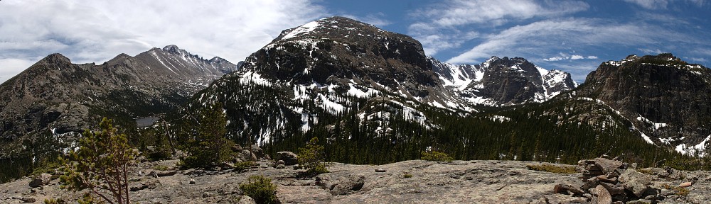
The topography of Middle Park differs markedly from that of North and South Parks making it isolated and relatively inaccessible. Middle Park isn’t oval, but Y-shaped. The southern entrance to Middle Park is Berthoud Pass. In the west, it stretches to Kremmling. And the northern arm is the valley where you will find the headwaters of the Colorado River. That is, where you’ll find Lulu City and Dutchtown.
Who Built Lulu City?
Because Middle Park was relatively difficult to reach, there’s not a long history of the place. The northern arm of the Park was a fertile hunting ground for the Northern Utes. Baldwin says “The streams were filled with fish, and game was abundant with elk, deer, mountain sheep, antelope, buffalo, all varieties of bear including grizzlies, grouse, sage hens, ducks, geese, and turkeys making Middle Park the best hunting ground in Colorado.” The Utes weren’t the only Indians aware of this and they had frequent conflicts with the Arapahos, Sioux, Crow, and Blackfoot Indians who also vied with the Utes for use of the region.
It wasn’t until after gold was found in Cripple Creek and Central City that whites were attracted to the place. Fremont wandered through the place in 1844, and Powell visited in 1868 (when he submitted Longs Peak), and there were a few other early visitors. But these were visitors. Whites didn’t settle here in any numbers until the 1870s.
Most of these early settlers were looking for gold. A number of mines were dug here on both sides of the Colorado River (originally called the Grand River; thus the name of Grand County and Grand Lake). There were enough people in the vicinity to warrant building towns, and thus Grand Lake and Lulu City were born, both in 1879.
Why is Lulu City a ghost town but not Grand Lake? Grand Lake was built more as a place to supply miners while Lulu was where the mines were. The basic problem was that the mines in the area supplied only low-grade ore. Access to Lulu was limited to wagon and horseback, and that was restricted by the harsh winters. Taking this low-grade ore out was difficult, and there wasn’t enough financial incentive to build a smelter at Lulu.
Lulu did have a sawmill, without which a town couldn’t be built. But that was about the extent of local industry. The plat of Lulu City (laid out by H.Y. Harding, Deputy U.S Surveyor, in early June of 1880) was conceived on an ambitious scale and encompassed 160 acres of land and was situated along the North Fork of the Grand River. Its east-west streets were numbered from 1st to 19th and those running north-south were given the names Lead Mountain, Trout, Riverside, and Howard.
Towns didn’t just spring up out of thin air. Generally, the first step was to make a company. In this case, it was the Middle Park and Grand River Mining and Land Improvement Company, created by a group of Fort Collins residents. They had an ambitious plan. According to the Fort Collins Courier, they “were supplied with tools and building materials and under the direction of Mr. Harris, an experienced mechanic, some eight or ten buildings will be put up before they return. A hotel, store, saloon, blacksmith shop, and various other business enterprises will be opened between now and mid-June. Steps are being taken to establish mail route from Fort Collins to Lulu City and other points in Middle and North Park. Management of the company is in the hands of competent and responsible people and no pains nor expense have been spared in acquiring perfect title to its property.”
A bustling place in the summers, almost no one stayed over the winter. The one road in was impassable until mid-June. The mines were for the most part deserted by late 1883 as was Lulu City. Postal service was discontinued on November 26, 1883, and no elections were held there that year. In December 1883 it was noted that “Lulu is practically dead for the winter, the bears having run everyone out of there. J.R. Godsmark, county judge elect, will winter at the Lake and as he has been the mainstay of Lulu, it will leave that place without a head.”
Much anxiety is felt for the safety of the mines at Lulu. Since the departure of Judge Godsmark and some more of the old timers, the bears and mountain lions have taken possession of the boys’ houses and old, discarded overalls and gumboots, and are running municipal government of their own, to wit; using all their efforts to restore Lulu to its primeval status. But wait until Judge returns and assumes the judicial ermine, then their rule will soon end. Lulu has bright future in store for her the coming summer.
Georgetown Colorado Miner, January 5, 1884
The bright future never happened. Lulu City was history before the end of 1884. The low grade of the ore, the lack of a smelter, and the harsh winters did the place in. There was never a school, never a church, and most of the buildings were tents. Joseph E. Shipler was one of the founders, and he was about the last to leave. Remnants of his cabin still stand, and he was greeting visitors as late as 1912, when Rocky Mountain National Park was founded.
Thursday, June 23
I left the house promptly at 6am. For these west side hikes, I generally take Berthoud pass in the morning and Trail Ridge Road in the afternoon, but today I decided to do TRR in both directions. This probably cost me nearly half an hour, but the hike is a short one so an 8:30 start is not a big deal. This summer, timed-entry passes are required at all times for the Bear Lake corridor, but only after 9am for the remainder of the Park. I arrived at the Beaver Meadows entrance station shortly after 7am. Only one gate was open and I waited in line for twenty minutes.
The trail parallels the Colorado River. It runs a few feet of elevation above the valley floor. It has to: much of the valley floor is marshy grassland. Foster says it’s 3.5 miles from the trailhead to Lulu, with a 320′ elevation gain. The sign on the trail has the distance at 3.7 miles. The 320′ is net gain, so you really climb a bit more than 400′ as the spur trail to Lulu is after the main trail has started rising from the valley. This little spur, about two-tenths of a mile, is easily the steepest section of the entire trail.
There’s one area where a “temporary” trail makes a detour. High water has washed away part of the trail. Rangers have marked the detour with little flags on each end of the detour, but in the middle the trail gets indistinct and several routes are possible, including one that I took which had a steep, wet, slippery section.
Foster lists this hike as “family-friendly”. I would agree with this, but the short detour might make it less friendly for little kids. As well, there are a number of downed trees that block the trail. Hopefully, these will be rectified this summer.
Shipler’s cabin ruins are somewhere along the trail. I never did see the place. I came across a little spur off the main trail. I went down this a few yards on my way up in the morning but gave up on it immediately. By the time I made it back here on the way back, I was convinced that Shipler’s cabin was down this trail. I was wrong.
There are a few places where the trail enters grassy meadows that are sufficiently high above the valley to not be marshes. Were I looking for a place to build a cabin in 1880 or so, many of these would have been possibilities.


Earlier, I said that this is one of the more popular hikes on the west side of the Park. I have no data to support this. And, in fact, on the hike up to Lulu, I only encountered two other hikers. But on arrival at Lulu, I came across a group of about fifteen guys, all sitting in a circle and telling stories. I stayed there for an hour. Another group of five or six arrived, along with a random selection of couples and solo hikers. On the way out, I passed a stream of hikers surpassed only by what you’d encounter between Bear Lake and Emerald Lake.
The location of Lulu is quite nice. It has a nice view (but not a spectacular one), and the river meanders a bit in a stony bed a few times wider than the stream itself. Here, we’re only about two miles from the headwaters and even in late June with the water running fairly high, it’s hard to imagine this river carving the Grand Canyon (there’s the old name again!). If I’d brought my trek poles with me, I’m sure I could have forded the river without taking my boots off and still had dry feet.
It took me only an hour and a half to get to Lulu, so it was a little early for me to have lunch. I thought I’d stop at Shipler’s cabin for my picnic, but as I mentioned above, that didn’t exactly work out. I found a nice rock with a view of a bend in the river.
On the hike out, I came across the most mellow marmot I’ve ever seen. He was on a rock right next to the trail when I found him. I didn’t see him until I was within a few feet of him. I thought he was unaware of my presence, but he could clearly hear the shutter of my camera. He got off his rock to eat some flowers right on the trail. Hikers coming from the other direction didn’t bother him either: he pretty much looked at me, turned his back on me, and walked right up to the other hikers. There, he ate some more flowers before finally leaving the trail and letting us all proceed.
I made it back to the car shortly after 1pm, for a round-trip time of just over four hours. As that included an hour at Lulu and a lunch break on the way back, it’s a pretty easy hike.


