Today was Ferrari of Denver’s customer appreciation track day. I’m not sure why they keep inviting me, as I haven’t spent any money there in about three years. But I’m very happy they continue to include me.
I was hoping to run on my slicks, but I couldn’t arrange transport for them. The day I registered for the event, I asked Ryan if he was going. Unfortunately, he did not get invited. In prior years, Ferrari of Denver had a trailer, so I asked them if they could take my wheels for me. Either they no longer have the trailer, or it was unavailable for this event. So, no shot to set a new personal best at HPR. And I really want to use up the slicks so I can get track tires that are street legal.
On the subject of tires, the street tires I’ve been using since I bought the car are no longer available. The fronts are still the Dunlops, but I recently put Kumhos on the rear. They’re the same treadwear rating (460) and have similar tread patterns. I figured they’d be a good match.
I think I figured wrong. I don’t think the tires like each other. On the interstates, where the surface is grooved, the car wants to change direction all the time. On the track, I found things very … unpredictable. In a straight line, it’s okay, but when changing directions, it’s darty. I’m thinking perhaps the Kumho sidewalls aren’t as strong. Maybe I can improve things by adding more pressure to the Kumhos.
Meanwhile, I’m still working on the transmission cable adjustment. When we put the new transmission in, third gear was an issue. I adjusted the cable and thought I had it fixed. I didn’t, so I adjusted it some more. It got better, but I don’t think I’m done with it. I discussed the symptoms and my attempts to fix it with FoD’s Lotus mechanic. In the end, he said that, if it’s a high-mileage car, I should replace the cables. I forget what number he used as high mileage, but it was quite a bit smaller than my actual mileage.
I understand the day was fully subscribed with eighty cars. I didn’t actually count them, but I know that not everybody who registered showed up. We had six Lotus: three Elises and three Evoras. One of the Evoras was Wayne, and one of the Elises says we’d met once before, and the others were new to me. I didn’t count the Ferraris, but there might have been thirty. And then there was a mish-mash of other marques: Porsche, Mercedes, Tesla, Audi, BMW. (See slideshow for a few examples, along with my guesses as to what each might be worth.)
Ferrari F8 (~$275,000?)
Mercedes AMG GT V8 Biturbo (~$175,000?)
I drove this one! Ferrari 458 Spider (~$275,000?)
Lucid (electric sedan, ~$90,000, >1000hp)
Ferrari 355 F1 (~$100,000?)
Audi TT RS (~$70,000?)
Ferrari 488 Pista (~$350,000?)
I gave a ride to one of my new Elise friends in the morning. At the end of our lunch break, I stopped by to chat with Wayne. He introduced me to Dave, who owns a 458 Spider. He was the third Ferrari owner I asked about getting to drive a few laps in their cars, and the first to agree.
First, I gave him a ride. I’d been running in the experienced group, but for his ride, we ran in the novice group. I enjoyed the session. I got to pass quite a few Ferraris. It’s not fair, of course, as I’m no novice. Many of these folks have never driven really fast. I was really slow my first time. But what disappointed me was how many drivers missed things from the drivers’ meeting: pass only with a point-by, pass only on the straights – not in turns, don’t pass under braking, and don’t get out of the faster car’s way. There’s a fair amount of sensory overload when you’re new to driving on a track, so I get that some drivers will get overwhelmed. But these are all very accomplished individuals who really don’t want to bend their expensive toys.
I had people go off-line to point me by, I had a guy pass in a turn without a point-by, and a number of people got out of my way and pointed me by in a turn. A couple of times, cars came right up behind me, then got in my blind spot. I don’t need to be wondering where people are hiding. These things happened in the experienced group, too, but not as often.
Anywho, after I gave Dave a ride, we switched to his 458. He drove a few laps first. It has paddle shifters, but we had it in automatic. In this mode, you only use the paddles to select or deselect neutral (or reverse, presumably, but we needed reverse). It’s a seven-speed gearbox and it’s pretty impressive.
I told him I’d be okay if we left all the driver aids on, but he dismissed that idea right away. I don’t know how to work his car, but it looked to me like we were in “race” mode, whatever that is. Dave isn’t a particularly fast driver yet (I passed him once or twice in earlier sessions), but he was error-free and his car control wasn’t bad.
I was behind the wheel for only three laps. I didn’t push it at all, but with each lap I was quicker. I was always pretty easy on throttle and brakes. As with when I drove the McLaren, the lap timer doesn’t work well in my pocket, so I don’t know what my lap times were. I did hit over 130 on the highway straight. I only made the tires squeal once.
The Ferrari 458 Spider is a V-8 that pumps out 560hp, which is just short of three times what my car manages. The 458 is about three-quarters of a ton heavier. The brake discs are enormous and the big wheels have fairly sticky rubber on them. I think I could get the car going pretty quickly if you gave me a day with it. Oh, and in normal highway driving, it gets as many miles per gallon as mine does at the track.
We ran with the top on. I think the only thing the Ferrari has less of than my car is headroom. Yes, I never run with the top on, so I have unlimited headroom, but with the hardtop on, my helmet doesn’t touch the top. In the Ferrari, I had to keep my head in a restricted area.
It was a blast to drive. It was great of Dave to let me drive it.
The whole day was a blast. Many thanks to the fine folks at Ferrari of Denver for their hospitality. They had donuts, plenty of cold water and other beverages, and fed us a nice barbecue lunch.
For today’s video, I’m doing something I haven’t done yet: post an entire session. This is with Dave as my passenger. It’s the novice group, so we encounter lots of traffic. It’s only a handful of laps, none of which are fast. But there are a lot of cool cars in it, so there you go.
I’ve had the Lotus for twelve years now. I still love it. But sometimes it’s a bit of a chore.
Leaving last month’s LoCo meeting, Chad pointed out that my driver’s side headlight is out. Sigh. Here is where I try to make a joke. How many Daves does it take to change a lightbulb? On the other hand, I wonder how much I might have been charged had I taken it to the Lotus dealer for the replacement? Note that the Lotus dealer is Ferrari of Denver.
The process is not exactly straightforward. You start by taking the front wheel off. From there, remove part of the wheel well liner to access the back of the headlight housing. The manual says to remove the three “socket head bolts”. That’s probably just a poor translation from English to American. I wouldn’t call them “socket head bolts” as they’re properly removed with an Allen wrench. In this particular instance, there are two rather than three.
After removing those fasteners, you just lift the cover off and it’s a relatively easy task to get the old bulb out and install the new one. It probably only took me half an hour to get to this point. Halfway there, right?
But why only two bolts?
Cheap-ass plastic.
The bolts thread through threaded clips and the clips are slipped over plastic tabs. And the plastic tabs break. One was completely broken, which explains my shortage of fasteners.
When I went to put it back together, it quickly became clear that it was a hopeless task. So I called on my resident mechanic to supervise.
I asked him if he had some glue that would do the job, but I knew it was a bad question as soon as I uttered it. Almost immediately I asked if, perhaps, we could bend some metal over it and fix it that way.
I’m not a fabricator, so I don’t have any bits of metal easily to hand. I thought maybe we could use some aluminum from a pop can, but as soon as I cut one up it was obvious it would be way too thin.
Luckily, Michael is a fabricator of sorts: he customizes die-cast models of big rigs. He found a piece scrap of scrap sheet aluminum that looked like it would make a nice repair. So, snip here, trim there, find some appropriately sized nuts and bolts, drill some holes, et voila! Job done. Well, something like that. We had to do this with both bolts. (And I probably should have done it for the missing one, too) It took a bit of fiddling to get things in the correct place, as all this has to line up with the holes in the back of the housing. But we made it work, and the cover is now more securely fastened than it was when we started.
And it only took 5 labor hours: 3 for me, 2 for Michael.
Last month I picked up a couple of timed-entry passes for July for the Bear Lake corridor. There aren’t any named lakes in the area that I haven’t already visited, except Marigold Lake, a very minor body of water more or less midway between Odessa Lake and the summit of Joe Mills Mountain. Perhaps I’ll manage to collect that one this summer. But not this time.
Wednesday, July 6
I picked Sky Pond for this trip, as it has been quite a while since I was last there. I described the trail in my last report, so I won’t repeat myself.
The mountains along the divide were wreathed in clouds that looked to be starting to break up a bit. The forecast was for a nice, warm day, so I expected things would clear up a bit. Hopefully the clouds would make for an interesting sky.
I managed to put boots on the trail a few minutes after 7 am and was at the base of Timberline Falls a bit before 9. There was a fair group at the falls, as this is the chokepoint for the hike. I don’t mind climbing up the section, but it always gives me a bit of heartburn on the way down. Especially “early” in the season, when the water flow is high and the spray gets all the rocks nice and wet.
Here I met volunteer Dan. We chatted for quite a while. I don’t recall his exact words, but he expressed some amazement that so many people manage to navigate up and down this steep bit without any “loss of blood”. He said the climb was much easier six weeks ago when it was all covered in snow. He was able to walk right up the slope.
Low hanging clouds
Timberline Falls. Note the hikers.
Glass Lake
Drone pilot and drone
The Sharkstooth
Habituated Mountain Goat
Sky Pond
The Loch, as seen from Timberline Falls
Even with the pass system in place, these popular trails can get quite crowded. I admit that I’m pretty spoiled on this point, but by seeking out some of the more obscure places in the Park, I can find quiet solitude. Quiet and solitude are quite often not available at Sky Pond. As soon as I sat down on a rock to enjoy the view, I heard somebody fire up a drone. They flew their drone nearly the entire time I was at the lake. I wonder if the drone pilot knew drones are illegal in the Park and was just thumbing his nose at authority, or if he didn’t realize he could be fined $5,000 and spend six months in jail. Just after he retrieved his drone, he looked in my direction and noticed that I was pointing my telephoto lens his way. I was a bit far away to discern his expression. Was it embarrassment?
After listening to the drone for the better part of half an hour, I went down to Glass Lake for another extended break. This time I ran across a woman listening to music as she searched for a spot to watch the world go by. Rather than using headphones or earbuds, she was broadcasting her taste in music to the world, or at least those of us who were trying to enjoy nature.
At the trailhead (well, not exactly the trailhead, but close enough), they have a notice warning of a “habituated” mountain goat in the area. I don’t think I’ve ever seen a mountain goat in the Park. I’d forgotten about this warning until I spotted said mountain goat, who seemed to be following a couple of hikers who didn’t notice who was behind them.
I chatted briefly with one of these hikers, who claimed to have spotted a fox. “I don’t know if it was a fox or a marmot. I think it went under this rock!” I’ve never seen a fox in the Park. That doesn’t mean there aren’t any, but I’m pretty sure what he saw was a marmot.
Back at The Loch, I found that one of the rocky peninsulas on the east side of the lake was unoccupied. These peninsulas, I think, give the best views of Loch Vale. I made my way there for my final extended break of the day. It was noon, and time for lunch. Today’s beer was a Roadie Grapefruit Radler by Great Divide Brewing Company.
On the shuttle bus back to the park-and-ride, the driver pointed out a large bull elk by the side of the road. His antlers were still quite velvety. The driver mentioned this; he would soon rub the velvet off. She told us not to be deceived: the antlers are quite sharp. She said a bull got a bit angry with this particular bus and punched a hole in the side. Naturally, when I disembarked I managed to forget to look for the hole. So it goes.
Robert Browning once said, “Ah, but a man’s reach should exceed his grasp, or what’s a heaven for?” We should aim high: there is value in attempting that which, in the end, may be impossible.
Today, we have (yet another) case where my reach exceeded my grasp. I had every intention of hiking to the summit of Mount Orton, but I succeeded only in reaching Sandbeach Lake. In times past, I’d have titled this post “Mount Orton FAIL”. I’m beginning to concentrate more on what I do than on what I fail to do. I think it’s important to have goals, even if we sometimes fail to attain them.
The plan was to climb (walk up, really) Mount Orton from Sandbeach Lake. Depending on whose numbers you use, Sandbeach Lake is 4.2 or 4.5 miles from the trailhead with an elevation gain of about 1,950′. From the lake to the summit is an additional 1.5 miles and 1,450′, and that’s off-trail. From the lake to the summit, then, should be less strenuous than the Manitou Incline, if you ignore the fact that you don’t have to hike four and a half miles before you start the incline.
There’s road construction on highway 7 that affects traffic starting at 7 am. With that in mind, I planned to arrive at the trailhead by around 7, which should get me to the lake by 9:30 or so, allowing me to take two hours to reach the summit and not worry too much about afternoon thundershowers. I felt it was a good plan.
Digression #1: Trail History
Many of the trails in the Park have been entered into the National Register of Historic Places. From my reading, most of the trails on the west side of the Park were developed with recreation in mind, with the routes scouted by and initial construction done by operators of Grand Lake hotels. The Sandbeach Lake trail, however, was initially a purely commercial endeavor.
Many lakes in Wild Basin were enlarged by building earthen berms. The extra water capacity was intended for use by farmers and ranchers around Fort Collins, Loveland, and Longmont. Off the top of my head, I count Bluebird, Box and Eagle, Pear, and Sandbeach. Also on the list, but not in Wild Basin, is Lawn Lake.
In the early 1900s, “the Supply Reservoir Company filed upon Sandbeach Lake, intending to make the natural lake into a reservoir.” That language isn’t very clear to me, but we can see that an earthen dam was built at Sandbeach Lake. From what remains of the dam, it appears that it raised the water level by perhaps twenty feet.
Much of the current hiking trail to the lake was originally a road that was built for the construction and/or maintenance of the dam. The company built a road from the Peak to Peak highway near Meeker Park that headed west. The current trail starts near Copeland Lake. The first section, to the junction with the Meeker Park trail, was not part of the road.
The application for the National Register (which I will just call “the application”) says, “Contemporary maps indicate that the road deteriorated over time. By 1917, it was designated one of the ‘poor automobile roads.’ Meanwhile, hikers and horseback riders discovered the route, effectively turning the old road into a tourist trail. In 1915, Rocky Mountain National Park’s first superintendent listed the pathway among the new park’s trail assets.”
Hiking the trail today, it’s easy to imagine a team of horses (or mules or oxen?) pulling a wagon over several significant sections of trail. The trail crosses Campers Creek and Hunters Creek and both crossings are wide, shallow fords easily passable by a modern 2-wheel-drive SUV. On the other hand, there are long stretches where I can’t imagine even a primitive road ever existed.
The application makes no mention of the only other bit of Sandbeach Lake history that I knew: the visit by John Wesley Powell. On his expedition to the area in 1868, the party camped at Sandbeach. While they were there, one of the party, a chap named Keplinger, explored the terrain up Hunters Creek and found the route the group took on the first-ever recorded summiting of Longs Peak.
Digression #2: Pondering Dam Building
Seeing where the trail could easily have been a road and seeing where the existence of a road challenges the imagination, I couldn’t help but wonder what sort of traffic, and for how long, this road needed to support.
It seems to me that that’s all determined by the construction of the dam. The dam was an earthen berm perhaps twenty feet high. I didn’t closely inspect what’s left of it on this trip, but I imagine that without modern earth-moving equipment, it would have been a non-trivial amount of work. Presumably, there would have been some sort of flood gate or valve installed about where the natural outlet was, and a spillway would have been created. The berm is fairly wide and at least a couple of hundred feet long.
How big of a crew did the work, and what sorts of tools did they employ? All this had to navigate the road. Was it done by truck or by wagon? I would think that, for the duration of the construction, the road would have seen regular use and have been what I’d call fairly “well-engineered”. However, I see little sign of engineering. There are no retaining walls or the like. The Park’s application includes the statement “Log bogwalks support the tread through flat, swampy areas. Some bogwalks look old, decomposing into the ground that they retain.” This application was written in 2007, and today I don’t see any bogwalks at all. So it doesn’t take long for things to change.
So, by 1917, the road had fallen into disuse and been claimed by hikers.
Digression #3: The Fate of the Reservoir
Looking at Sandbeach Lake today, it’s fairly obvious how much higher the water level was when it was enlarged. The trees between the current water level and the old level look to be about as mature as the trees that have grown back where the Ouzel fire burned back in 1978.
So when was the reservoir removed? The answer lies in the Lawn Lake flood of 1982. After that flood, the park began the process to remove some of the dams built around the turn of the twentieth century. In 1988, they removed the rock and dirt dams at Sandbeach and Pear Lakes. The shorelines were regraded to the original slope and the shores have been allowed to restore naturally with a minimum of supplemental planting, although they did plant willows around the Sandbeach outlet to create spawning habitat for greenback cutthroat trout. (In 1989 and 1990, five million pounds of concrete and rebar were removed from the Bluebird Lake dam and flown out of the backcountry. It boggles my mind to think of how so much material was emplaced at Bluebird in the first place.)
Wednesday, June 29
I can’t help but note that there are signs at the Wild Bain entrance station stating that timed-entry passes are required for visits starting at 9 am. It also seems to me that they don’t have any rangers working at the entrance station. I’m guessing the passes aren’t enforced in Wild Basin. Not that it matters that much: if you don’t get there well before 9, you won’t find a place to park.
Just as soon as I got out of the car, I heard some crashing in the undergrowth nearby: a cow moose was making her way through the area. I find it amusing that I often see a moose within twenty yards of my car and I can hike for hours and not see one in the backcountry.
I was early enough that I didn’t encounter too many hikers on the trail. I ran across two guys hiking out. They weren’t walking together, but I assumed they were together. I chatted with the second one. I told him I intended to summit Orton and that got him talking. He asked if I’d ever been to Ellington Lake. I told him I’d day-hiked to every lake in Wild Basin except Isolation and Frigid but that I’d never heard of Ellington Lake. He told me I wouldn’t be able to get there, as I had insufficient gear with me. It wasn’t until a few moments after parting ways that I figured out what he was talking about: Keplinger. Three syllables, same second syllable, same vowel sound in the first syllable. And in June, the lake would still be well frozen over and much snow would have to be crossed to reach it.
By the time I reached the lake at 9:17, pretty much spot-on my schedule, it was growing clear to me that I wouldn’t get to where I wanted to go. I’ll admit that the weather-related aspect of my hike planning goes something like this: “Well, it’s going to be 95 degrees in Denver. Sounds like a good day to hit the high country!” This is generally not a bad plan. But today it didn’t work out for me.
I was dressed in shorts and an aloha shirt. The only extra layer I brought was a thin waterproof shell. Instead of bright sunshine and warm temperatures, there was a large darkish cloud hanging over the Divide: sunshine well to the west; thin, high clouds over the plains. And it was a bit breezy. It seemed to me that the clouds were dark enough that they might produce some rain. I would likely be miserable above treeline.
I made a half-hearted attempt to start bushwhacking my way up the slope but abandoned it pretty quickly. I had made little attempt to find anything like a trail that might lead up the mountain but after I turned around I stumbled on a trail that might do the trick. I may not be able to walk right up to that trail next time I want to do this, but knowing that it’s there is enough, and I’m sure I’ll find it when the time comes.
Trailhead Moose
View to the south
There’s a fungus among us
View to the north
Moose tracks on the beach
Trees at left were above reservoir level
Dendrochronology test
In the end, I stayed at the lake for nearly two hours. I’m surprised I lasted that long. I found a nice rock on the shore with a nice view of Mt. Meeker, Longs Peak, and Pagoda, but with the cloud cover and wind, I really didn’t want to sit there. I could almost get out of the wind by hanging out in the nearby trees, and I walked around a bit, up to the old reservoir shoreline to check out the wind-gnarled trees. I didn’t want to eat lunch yet, as it was still early. I ended up stopping at Hunters Creek for my lunch.
When I made the decision to stay at the lake, I was feeling a bit disappointed with myself. “Don’t be such a wimp! You can make it, don’t be so lazy!” By the time I ate lunch, my attitude had changed. I was cold at the lake, where I could find at least a little shelter from the breeze. Another 1500′ up, above treeline, I’m sure I’d have been miserable. I think I’d have made a more sincere effort to continue if I’d have found the trail, but I’m convinced I made a sound choice to stop. I didn’t see my shadow between about 8 am and when I got back to Lyons.
I’m not sure I’ll make another stab at Mt Orton as a day hike. I think it’s within my range, but I’ll admit to beginning to think that my range probably isn’t what it was a few years ago. In my wanderings around the east shore of the lake, I took a good look at the campsite there. It’s one of the nicer ones I’ve visited. The privy even has walls! This looks like a good place to spend a night and making an early assault on the summit.
For several years, I’ve been telling people that I try to spend between twelve and eighteen days each year in the Park. I’ll admit that what I tell people may sometimes be an exaggeration, but I think I’m safe in saying that I’ve averaged more than a dozen days a year since 2008. If I pull a number out of the hat for visits prior to 2008, I might have spent another eighty days total. That means I’ve spent a total of over 260 days wandering around the Park. And yet, somehow, I’ve never been to Lulu City, one of the most popular hikes on the west side of the Park.
Ghost Town
Before seeing the place, I might have called it a ghost town.
I tend to spend a lot of time planning my little jaunts, and this one was no different. Usually, my research is reading a few paragraphs of Foster’s guide, then pulling up the area on CalTopo maps. My habit is to leave this browser window open for days or weeks, looking at it a couple of times a day. For Lulu City, though, I dug a bit deeper.
I have a giant book called Ghost Towns of the West that was published back in 1971. In the introduction, the authors define a ghost town. They say, “Most of the towns described and pictured in this book are ‘dead’ ghosts, but some still have life, though nothing to compare with the lusty vigor they enjoyed in their heyday.” Their chapter for Colorado is 112 pages. There’s no entry for Lulu City, but there are entries for Black Hawk, Breckenridge, Buena Vista, Central City, Creede, Crested Butte, Fairplay, Georgetown, Leadville, Silverton, and Telluride, among other places I’d never have considered “ghost towns”. I find this unsatisfying.
Digging deeper, I managed to find a paper written in 1980 that covers Lulu City and Dutchtown. I have a backcountry permit to stay at the Dutchtown campsite in August, so I’ll leave that part of the story for later.
What’s a Park?
The first chapter of this paper (authored by Susan Baldwin) gives a history of Middle Park. Here I will confess that, having lived in Colorado for more than four decades, and having heard the name “Middle Park”, I never knew where it was.
In this context, a park is a large upland valley. The word comes from the French word “parc”, which means “enclosure”. The principal ones are North Park (which was originally called “New Park”), Middle Park (originally “Old Park”), South Park, and the San Luis Valley. I’m quite familiar with North, South, and San Luis. These are large basins, lie at relatively high altitudes, and are miles across in all directions. “Basin” is a fitting term, in my opinion. I have never really thought of North Park or South Park or the San Luis Valley as valleys. They’re all more or less oval shapes, have flat bottoms, and lack trees.
The topography of Middle Park differs markedly from that of North and South Parks making it isolated and relatively inaccessible. Middle Park isn’t oval, but Y-shaped. The southern entrance to Middle Park is Berthoud Pass. In the west, it stretches to Kremmling. And the northern arm is the valley where you will find the headwaters of the Colorado River. That is, where you’ll find Lulu City and Dutchtown.
Who Built Lulu City?
Because Middle Park was relatively difficult to reach, there’s not a long history of the place. The northern arm of the Park was a fertile hunting ground for the Northern Utes. Baldwin says “The streams were filled with fish, and game was abundant with elk, deer, mountain sheep, antelope, buffalo, all varieties of bear including grizzlies, grouse, sage hens, ducks, geese, and turkeys making Middle Park the best hunting ground in Colorado.” The Utes weren’t the only Indians aware of this and they had frequent conflicts with the Arapahos, Sioux, Crow, and Blackfoot Indians who also vied with the Utes for use of the region.
It wasn’t until after gold was found in Cripple Creek and Central City that whites were attracted to the place. Fremont wandered through the place in 1844, and Powell visited in 1868 (when he submitted Longs Peak), and there were a few other early visitors. But these were visitors. Whites didn’t settle here in any numbers until the 1870s.
Most of these early settlers were looking for gold. A number of mines were dug here on both sides of the Colorado River (originally called the Grand River; thus the name of Grand County and Grand Lake). There were enough people in the vicinity to warrant building towns, and thus Grand Lake and Lulu City were born, both in 1879.
Why is Lulu City a ghost town but not Grand Lake? Grand Lake was built more as a place to supply miners while Lulu was where the mines were. The basic problem was that the mines in the area supplied only low-grade ore. Access to Lulu was limited to wagon and horseback, and that was restricted by the harsh winters. Taking this low-grade ore out was difficult, and there wasn’t enough financial incentive to build a smelter at Lulu.
Lulu did have a sawmill, without which a town couldn’t be built. But that was about the extent of local industry. The plat of Lulu City (laid out by H.Y. Harding, Deputy U.S Surveyor, in early June of 1880) was conceived on an ambitious scale and encompassed 160 acres of land and was situated along the North Fork of the Grand River. Its east-west streets were numbered from 1st to 19th and those running north-south were given the names Lead Mountain, Trout, Riverside, and Howard.
Towns didn’t just spring up out of thin air. Generally, the first step was to make a company. In this case, it was the Middle Park and Grand River Mining and Land Improvement Company, created by a group of Fort Collins residents. They had an ambitious plan. According to the Fort Collins Courier, they “were supplied with tools and building materials and under the direction of Mr. Harris, an experienced mechanic, some eight or ten buildings will be put up before they return. A hotel, store, saloon, blacksmith shop, and various other business enterprises will be opened between now and mid-June. Steps are being taken to establish mail route from Fort Collins to Lulu City and other points in Middle and North Park. Management of the company is in the hands of competent and responsible people and no pains nor expense have been spared in acquiring perfect title to its property.”
A bustling place in the summers, almost no one stayed over the winter. The one road in was impassable until mid-June. The mines were for the most part deserted by late 1883 as was Lulu City. Postal service was discontinued on November 26, 1883, and no elections were held there that year. In December 1883 it was noted that “Lulu is practically dead for the winter, the bears having run everyone out of there. J.R. Godsmark, county judge elect, will winter at the Lake and as he has been the mainstay of Lulu, it will leave that place without a head.”
Much anxiety is felt for the safety of the mines at Lulu. Since the departure of Judge Godsmark and some more of the old timers, the bears and mountain lions have taken possession of the boys’ houses and old, discarded overalls and gumboots, and are running municipal government of their own, to wit; using all their efforts to restore Lulu to its primeval status. But wait until Judge returns and assumes the judicial ermine, then their rule will soon end. Lulu has bright future in store for her the coming summer.
Georgetown Colorado Miner, January 5, 1884
The bright future never happened. Lulu City was history before the end of 1884. The low grade of the ore, the lack of a smelter, and the harsh winters did the place in. There was never a school, never a church, and most of the buildings were tents. Joseph E. Shipler was one of the founders, and he was about the last to leave. Remnants of his cabin still stand, and he was greeting visitors as late as 1912, when Rocky Mountain National Park was founded.
Thursday, June 23
I left the house promptly at 6am. For these west side hikes, I generally take Berthoud pass in the morning and Trail Ridge Road in the afternoon, but today I decided to do TRR in both directions. This probably cost me nearly half an hour, but the hike is a short one so an 8:30 start is not a big deal. This summer, timed-entry passes are required at all times for the Bear Lake corridor, but only after 9am for the remainder of the Park. I arrived at the Beaver Meadows entrance station shortly after 7am. Only one gate was open and I waited in line for twenty minutes.
The trail parallels the Colorado River. It runs a few feet of elevation above the valley floor. It has to: much of the valley floor is marshy grassland. Foster says it’s 3.5 miles from the trailhead to Lulu, with a 320′ elevation gain. The sign on the trail has the distance at 3.7 miles. The 320′ is net gain, so you really climb a bit more than 400′ as the spur trail to Lulu is after the main trail has started rising from the valley. This little spur, about two-tenths of a mile, is easily the steepest section of the entire trail.
There’s one area where a “temporary” trail makes a detour. High water has washed away part of the trail. Rangers have marked the detour with little flags on each end of the detour, but in the middle the trail gets indistinct and several routes are possible, including one that I took which had a steep, wet, slippery section.
Foster lists this hike as “family-friendly”. I would agree with this, but the short detour might make it less friendly for little kids. As well, there are a number of downed trees that block the trail. Hopefully, these will be rectified this summer.
Shipler’s cabin ruins are somewhere along the trail. I never did see the place. I came across a little spur off the main trail. I went down this a few yards on my way up in the morning but gave up on it immediately. By the time I made it back here on the way back, I was convinced that Shipler’s cabin was down this trail. I was wrong.
There are a few places where the trail enters grassy meadows that are sufficiently high above the valley to not be marshes. Were I looking for a place to build a cabin in 1880 or so, many of these would have been possibilities.
Never Summer Peak
Mine Tailings
Howard Mtn
Howard Mtn
Never Summer Peak
Spot the Moose
Standing in the middle of the Colorado River
My Marmot Friend
Earlier, I said that this is one of the more popular hikes on the west side of the Park. I have no data to support this. And, in fact, on the hike up to Lulu, I only encountered two other hikers. But on arrival at Lulu, I came across a group of about fifteen guys, all sitting in a circle and telling stories. I stayed there for an hour. Another group of five or six arrived, along with a random selection of couples and solo hikers. On the way out, I passed a stream of hikers surpassed only by what you’d encounter between Bear Lake and Emerald Lake.
The location of Lulu is quite nice. It has a nice view (but not a spectacular one), and the river meanders a bit in a stony bed a few times wider than the stream itself. Here, we’re only about two miles from the headwaters and even in late June with the water running fairly high, it’s hard to imagine this river carving the Grand Canyon (there’s the old name again!). If I’d brought my trek poles with me, I’m sure I could have forded the river without taking my boots off and still had dry feet.
It took me only an hour and a half to get to Lulu, so it was a little early for me to have lunch. I thought I’d stop at Shipler’s cabin for my picnic, but as I mentioned above, that didn’t exactly work out. I found a nice rock with a view of a bend in the river.
On the hike out, I came across the most mellow marmot I’ve ever seen. He was on a rock right next to the trail when I found him. I didn’t see him until I was within a few feet of him. I thought he was unaware of my presence, but he could clearly hear the shutter of my camera. He got off his rock to eat some flowers right on the trail. Hikers coming from the other direction didn’t bother him either: he pretty much looked at me, turned his back on me, and walked right up to the other hikers. There, he ate some more flowers before finally leaving the trail and letting us all proceed.
I made it back to the car shortly after 1pm, for a round-trip time of just over four hours. As that included an hour at Lulu and a lunch break on the way back, it’s a pretty easy hike.
I can’t wait to get the summer hiking season going. This is often a slight problem in the first week of June: in Denver, it seems summer is here, but where I want to hike, it’s not summer at all. A hike in the first week of June always means hiking over snow when you get over about 10,000′. Perhaps even more so, given our two large storms in late May: one that dumped enough snow here at the house to produce a truckload of broken tree limbs, and one a week after that that produced over an inch of precipitation that manifested as about eighteen inches of snow above 9,000′.
Having neglected to plan ahead by purchasing a timed entry pass for RMNP, I decided another visit to James Peak Wilderness would be a good alternative. Of the five hikes here, the lakes that are lowest are Forest Lakes. I did this hike last year about this time, so this will be a repeat.
June 3, 2022
In July and August, you have to get to the trailhead quite early to find a parking place. On a weekday in the first week of June, parking isn’t a problem. I arrived at about 8:15 and was the third car in the lot. At the trailhead, I signed into the log book as the first entry of the day. Either the parties belonging to the other two cars camped overnight or neglected to sign in.
On the lower part of the trail – the first quarter of a mile – the trail isn’t so much a trail as a small river. The next quarter-mile, the trail is in shade. There wasn’t any snow on the trail, but banks of snow lined both sides of the trail. Clearly, I’d be dealing with a bit more snow than last year. Last year, we didn’t start hiking on snow until after we crossed the bridge over Arapaho Creek (at about 9,800′). Today, I was trudging over snow almost 500′ lower. So it goes.
Given the recent snows and the apparent small number of visitors, I was a bit concerned about route-finding. There were quite a few tracks in the snow just above the bridge, but they quickly petered out until there were only two sets: a pair of snowshoe tracks heading up, and the tracks of a hiker just in boots that looked to be a round-trip: both uphill and down. One thing about following tracks in the snow: you have to hope that the people making the tracks went where you want to go, and they know how to get there.
I didn’t bring snowshoes but did have the micro-spikes. The snow was pretty good – I only postholed twice on the way up to the lake. At the lake, I met the hikers who left the snowshoe tracks. They had hiked up yesterday and camped at the lake. Last year, there were plenty of snow-free rocks around the lake to sit on. Today there was just one. The three of us sat there and had our picnics.
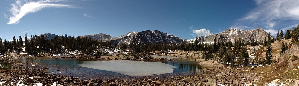
View of the Contental Divide
Panorama shot
Only the lake’s outlet is free of ice
Meadow snow melting
Stream carving snow
I hung out for about an hour before packing up to leave. In this time, with the sun shining brightly on the snow, my hike out was slightly transformed. Each day the sun works its magic on the top of the snow, melting it a bit. Then, overnight, the top freezes, making it easy to walk on in the morning. My hike out was quite different than the hike in: I postholed hundreds of times. That’s only a slight exaggeration.
It may be counter-intuitive that the snow melts from the bottom, not the top. For the most part, you want to hike along the tops of the snowbanks and avoid stepping next to any rocks or trees that may be poking through the snow. Anything darker than the snow will heat up faster than the snow. If you step next to it, you’ll likely posthole either to mid-thigh or until your boot hits something solid. And, because the snow melts from the bottom, whatever solid you hit will be covered by running water. And any low spots between the tops of the snowbanks are good places to posthole, too.
I ran across one guy hiking to the lake and another couple quite near the trailhead. When I got back to the car, the parking lot was not quite twice as crowded as in the morning: there were now five cars in addition to my own.
Here’s a short timelapse of the sky. Notice that my camera slowly melted into the snow.
At the end of March or early April (I don’t recall exactly), two of the posts holding up the fence on the north side of my garage failed during a windstorm. They just rotted through at ground level until a nice, stiff breeze blew the fence over. By “stiff breeze”, I really mean sustained winds exceeding 40mph with gusts over 50mph. I see we had four days like that between 3/22 and 4/5.
When I did my last fence repair (a section on the south side of the house), I just set the posts in some angular pea-sized gravel rather than concrete. The original builder didn’t use concrete and it wasn’t the posts that failed, so I didn’t see the need to set the posts in concrete. Once you tamp the gravel in, the edges lock together making it quite strong. It has been nine or ten years and none of those posts move.
Here, though, the existing fence was set in concrete. I was disappointed, but not surprised. The post next to the garage wall was your standard 4×4 post. The other post, on which a gate hangs, was a 4×6. I searched the internet but didn’t find anybody who had 4×6 lumber in stock. During my daily walks I checked out a number of fences with RV gates and they all used 4×4 posts. My fence and gate are only 4′ tall, and all the ones I looked at were 6′ fences. The moment exerted on my post by a 4′ tall gate should be considerably less than that of a 6′ tall gate so I figured the 4×4 should be plenty strong.
My plan was to try to dig as small of a hole as necessary to allow me to bust up the old concrete with a sledgehammer. Even so, any such hole would be far too big for me to fill with concrete, so I picked up a couple of those cardboard tubes and use them as forms.
The issue with the one next to the garage was I’d be limited to working from three sides, as the fourth side is right up against the foundation. The gate post wouldn’t be much easier: clearly, the concrete for the post pre-dated the concrete slab. In neither case would it be a straightforward sledgehammer job. One took me an hour and a half, the other just an hour.
Wind graph, late March/early April
Blown-down section
Rotted gate side post in concrete
Need to not hit slab with sledge…
Rotted garage side post in concrete
As clean as I’ll get it
Gate side post ready for concrete
Garage side post ready for concrete
Posts set and irrigation trench dug
Fence section replaced. Note the height of the posts…
All done, including stiffeners
I placed the tube forms and backfilled the holes with dirt. For concrete, I used a couple of sacks of the pre-mixed concrete: pour the dry mix into the hole and just add water. I let the concrete set for a day before putting the fence section back into place. Maybe I should have replaced the section, but it’s still in pretty good shape, except for a bit of rot where the slats touched the ground.
I managed to have the foresight to cut the post to the correct height on the gate side, but had the section up before I noticed I neglected to cut the garage side one. I never seem to do things the easy way.
The next trick was hanging the gate. The gate has never operated freely. It has always sagged a bit. To open it, you had to lift the end of it to get it to open. I had the feeling that the sag had increased over time. I decided part of the problem is that there’s insufficient structure to keep it square. I decided to add a couple of sheets of scrap and screw them to the slats to stiffen it.
And, finally, was the issue of the carriage bolts. They go through the 4×4 and a 2×4 and a slat. So they’re pretty long. Longer, in fact, than are available at Home Depot, Lowes, or Ace Hardware. So I had to re-use the old bolts. They bent a bit when I took them out, so I straightened them with the vice. And I didn’t have a drill bit long enough to go through all that material, so I had to measure very carefully and drill the hole from each end.
The side of the gate I rehung on the new post works beautifully. It swings freely. So I did the stiffening thing with the small sheets on the other half of the gate. This had no effect at all. I still cannot open the gate fully and have to struggle to open it halfway. I haven’t verified, but I’m guessing this post is no longer plumb. But I’m not willing to replace this post just to get the gate to work better. The two posts, tubes, concrete, and fasteners for the repairs I did amounted to about $130 and involved several hours of hard labor. Maybe next summer I’ll tackle the other side.
Finally, there was a small gravel patch next to the garage where a sort of utility shed stood. The previous owner of the house did woodworking in the garage and this shed housed, I believe, a shop vac (to evacuate the sawdust) and maybe an air compressor. There was a sizeable hole through the wall. I had the hole fixed when the garage was resided as part of my giant house painting project last year.
This gravel patch is a bit of an eyesore, so I dug a trench to extend an existing sprinkler line so I can add another head to the irrigation system. With the new head covering that area, I added a bit of topsoil and spread some grass seed. We’ll see how well this works as the area is in shade almost all the time.
The Manitou Incline is a trail that climbs a bit over 2,000′ in less than a mile. The sign at the base of the trail tells us there are 2,744 steps to the top, but a marker on the top step tells us it is the 2,768th. Evidently, the count varies somewhat over time due to trail maintenance. It is, by far, the steepest trail I’m aware of. By contrast, in RMNP, the steepest sections of any trail that pack animals are allowed on climbs about 400′ in six-tenths of a mile (a kilometer). To climb two thousand feet at that slope would take three miles.
So many people want to subject themselves to this torture that reservations are required.
I had the mental image of somebody standing at the bottom of this hill a hundred years ago and saying to themselves, “I know: let’s make a hiking trail that starts here and goes straight up to the top. That would be fun!” This imaginative scenario is not correct. The somewhat more reasonable story is that the trail is the remains of a narrow-gauge funicular railway whose tracks washed out during a rock slide in 1990.
(A funicular is essentially a cable car. Two cars, actually, attached to the cable and used to counterweight each other. Cog railways also are used to climb steep slopes, but they don’t use cables. The Pikes Peak Cog railway starts just a few yards from the base of the Incline.)
They say one should allow two hours to get to the summit. The record is in the seventeen-minute range. Some folks seem to think doing it once isn’t enough, so they came up with the “Inclinathon”: 13 consecutive trips up and down the Incline in one day and has been completed in less than 12 hours.
I’ve been thinking of tackling this challenge for a number of years. Somehow it never really bubbled to the top of my to-do list. A couple of weeks ago, Chad reached out to me and asked if I wanted to join him.
Friday, April 8
Our reservations were in the 9:30-10:00 am slot, and we arrived in the area right on time. We found a parking lot with lots of open spaces, but it’s parking for the Barr Trail, and Incline hikers aren’t allowed to park here. Next, we found the lot for the Pikes Peak Cog Railway. No Incline parking here, either. We finally found the right place, which, naturally, adds a quarter of a mile and maybe 200′ of elevation we’d need to gain.
We couldn’t have asked for better weather. The forecast high was for the mid-60s and calm. At the start, it was still cool enough to wear a hoodie but with the bright sunshine and cloudless cerulean sky, we were soon down to shirtsleeves and getting out the sunscreen.
We hit the first step of the incline at 9:36, at the same time as a woman and her son who looked to be about six years old. An indication of my performance on this hike is that I only managed to beat this six-year-old to the top by a few minutes. Judging by the dirt on the seat of his pants, he spent a lot of time waiting for his mother (and us other slow hikers) to catch up to him.
It wasn’t my lung capacity that was the limiting factor here. It was my legs. Most of the steps are single railroad ties, but in the steeper parts, each step is two railroad ties. And in some places, the ties are so close together that the tread width of the step is shorter than my boot is long. (The Incline is famous for its steepness, with an average grade of 45% (24°) and as steep as 68% (34°) in places.)
Not far from the bottom, a small herd of deer browsed their way across the trail. They’re quite acclimated to people; several of them came within 8 or 10 feet of me. I think I might have been able to pet them, had I been so inclined. Sorry for the pun.
I didn’t see anybody running up, but quite a few ran down. I thought I saw somewhere that the Incline is one-way: climb up the Incline and take the Barr Trail back down. The hardcore group didn’t get enough agony on the trip up, they had to compound it by going back down the steps. No way I could have done it. We saw one guy who made two trips, and one gal we encountered was going down the steps backward. She said it was easier on the legs and falls wouldn’t be so bad. She said she would make a second ascent as soon as she got back to the base. At this point, I have no plans to do it a second time in my life, let alone a second time in a day.
There’s a marker on every hundredth step so you have a good idea of just how much torture still lies ahead of you. Or maybe I should say “above you”. I never bothered to count, so I don’t know how accurate these markers are. When we reached step 2000, I was a few steps above our intrepid 6-year-old. Naturally, he was unable to fight the need to start counting: “2000, 2001, 2002, 2003, …”.
At one point, I looked up and decided that I’d only need to take two more breaks before reaching the top. Seems I did this when looking at a bit of a “false summit”. I could see the top, but it didn’t look as far as it actually was, and a particularly steep section was obscured. I think I actually stopped five or six more times. Chad was a good sport about it and slowed his pace to stay with me. I have no doubt he’d have finished on the order of half an hour quicker than me.
Because I kept stopping to rest, I had plenty of opportunity to look at how the trail was made. For the most part, the timbers are flat, level, and square. They’re all attached with fittings to stout cables on each end, and the cables are anchored in concrete periodically up the slope. But, hikers and the weather have conspired to shift some of the ties so that they’re rotated a bit, or the soil behind them is starting to wash away. I imagine they need to constantly do a fair amount of work to keep the trail in good enough condition to support the traffic it gets.
We gained the summit at noon precisely. I had the forethought to pack a couple of beers. They were (amazingly) still cold. I didn’t set any records in climbing the Incline, but I did suck that beer down my gullet in pretty quick time.
The view from the parking lot.
Obligatory selfie at the base.
Warning!
Not so wild wildlife.
We’re doing this for fun?
Almost to the top. Some of us are nearly crawling.
Last step: #2768
At the top, looking down.
The hike down the Barr Trail is quite pleasant in comparison to the Incline and doesn’t merit much description, other than that it’s fairly highly engineered (many retaining walls and fences) to handle the traffic.
I’m writing this the next day. My calves are quite sore. I’ll try to minimize my trips up and down the stairs today.
We took the Elise out of service the first week of November.
All my adult life when it came to cars, I thought I was pretty kind to the equipment. I kept my cars longer than just about anybody I knew. My brakes, tires, and clutches didn’t wear out as fast as they did for most of my friends and acquaintances.
It’s no surprise, then, that I’ve been beating myself up a bit about the Elise. I’ve had suspension failures and a bad cam. I haven’t heard of anybody else having the hub carrier plinth bolt issue, and nobody thinks it’s a maintenance issue. But after having both sides fail, I’ll be replacing the bolts every few years. The bad cam seems to be the luck of the draw. I went about 60k miles before having the problem. I’ve heard many reports of it happening a lot sooner. Then there’s my “money shift”. Pure driver error on that one.
And, now, the third gear synchro. It started going out about a year ago. Before I decided it was the synchro, I worried that it was damage resulting from the money shift. I went into third instead of fifth. Did that break my third gear? But, no, not related. More likely due to my not rev-matching. I don’t know. Anyway, the transmission is replaced at 92k miles, so it started at about 87k and 50ish track days.
But let’s go back to November. We didn’t park it until then, but I had been looking for a solution. What I ended up doing was buying a rebuilt transmission off Lotus Talk. The seller was at one point part of the Lotus Service Exchange and in this role rebuilt about 65 Elise/Exige gearboxes. (This one has the LSD, so I’m replacing same for same.) Seller says, “It had 9000-11000 miles on it when it was pulled for a notchy third gear. I installed a new synchro and inspected the rest of the gears.”
My original thought was just to get mine repaired. Michael and I could take it out of the car to save some labor costs. I talked to a number of people. I was surprised nobody wanted to do the work. The closest I got to anything like a quote on the work was nearly twice what I ended up paying for the rebuilt one. So it was cheaper to put in a repaired one with about 10k miles on it than to have similar work done to my 92k mile one.
In all my looking around, I came to the conclusion that these transmissions are notorious for third gear synchro issues. In the Lotus at least. The guy I bought mine from had two others for sale, and the one I bought the most miles on it. Searching the forums and talking to people, nobody I’ve encountered who has had the third gear synchro fail had anywhere near the mileage or track days I’ve done.
So I guess, in spite of all my repairs, I’ll continue to suffer from cognitive dissonance and believe I’m kind to the equipment.
The transmission arrived nicely boxed up. He built a frame of 2x2s with a plywood base, strapped it in so it wouldn’t jostle about, and stapled corrugation to the exterior. Unfortunately, we destroyed the box when we took it out. I wasn’t thinking about what I’d do with the one we’re taking out. I’m pretty sure now that I’m going to build this type of box for both the transmission and the motor I took out last year. Boxed up, they’ll be much easier to both move and store. I could stack them!
The whole replacement operation took a bit longer than we anticipated. My original hope was to be back on the road by Christmas, so I could participate in HPR’s customer appreciation day. We weren’t even close, but so it goes. Other than not wanting very much to work in the garage when it was cold, and it seemed all our warm weather was during the week, we also ran into a couple of minor issues.
One was the replacement transmission with where a stud mounts. The threads were damaged. Michael borrowed a tap and die set from his work and the repair was fairly easy. So we have an oversized stud in there now.
The other “minor” issue didn’t cause us any delays. I had to buy a couple of bell housing bolts. When we dove into the job, we noticed we had a few fasteners missing. Two of the bell housing bolts were gone, and so was a nut on the driver’s side motor mount. I know the race car guys are always going over their cars making sure all the nuts and bolts are properly torqued. I never worried about it, but clearly, the solid motor mounts are just vibrating the thing apart. So I guess I need to take the clam off once a year and check all the nuts and bolts.
The replacement, nicely boxed
The extraction…
The old and the new
Minor problem
Ready for the test drive
I did a time-lapse of the clam removal. I was thinking it might be cool, but, frankly, I’m underwhelmed. I didn’t mean to leave the timestamp on the camera, but it lets you know how long the process took. I have a “quick disconnect” kit so we don’t have to take the seats out. Oh, and you may notice Michael removing a broken passenger side rear side-marker light.
I’ve only driven it around the block (before we put the clam back on — that always gets some odd looks). Going around the block isn’t a real test, but at least I know I can select all the gears. I’m quite happy to have it back now that the weather is getting nice!
With just about zero advance planning, Ed and I returned to Lake Haiyaha, where we had just visited less than two weeks ago. We arrived at the Bear Lake parking lot with no destination in mind, but with the warm temperature and (seemingly) calm winds, we decided it might actually be pleasant enough at Haiyaha that we wouldn’t freeze our fingers off if we tried to take pictures of the ice.
Our prediction was spot-on. I never took my gloves out of the pack. We spent about an hour at the lake, wandering around inspecting the endlessly fascinating ice, eating our picnic lunches, and occasionally chatting with other visitors to the lake. I even ran the GoPro, thinking the thin veil of high clouds would be both interesting and calming. Sadly, the camera fell on its back after about seven minutes, shooting straight up until the battery was exhausted. No timelapse video again this hike. So it goes.
I am left, then, trying to show what the ice looks like. I probably should just put these in a slide show and be done with it, but instead, I’ll blather on and on about each shot.
Here we see Ed working on getting some photographic evidence. Huddled around these rocks poking through the ice, we could occasionally hear a soft crack. The ice is constantly, slowly, dropping. It’s a mosaic of many pieces, large and not-so-large, and if you listen carefully (and the wind is calm, as it is today), you can hear it settle.
Where the rocks punch through the ice (which drops something like eight or ten or fifteen feet over the course of the winter, due to the lake having a leak) we can see the ice from the side. It’s a pale blue over most of the lake and filled with columns of tiny air bubbles.
Next to one of the larger boulders where the wind swirls madly, the ice is almost perfectly clear and has very few of the little bubbles we see in the light blue ice covering the rest of the lake. It’s sometimes difficult to figure out its shape, as it features no flat surfaces and lenses the light unpredictably. Most interesting here, I think, is where it at first looks like there’s some snow on top of the ice, with gaps in the snow like the holes in swiss cheese. But it’s not really snow, and it’s not on top of the ice, but a layer in the ice. Where the layer below this seeming snow is absent, I ran my finger along the under surface. Where it looks like snow, these are voids with the bottom of the ice, coated by tiny crystals that look like snow. Note the crack in the upper layer, curving from the lower left of the frame through the center.
I was unable to get a decent photo of the ripples on the absolutely clear ice, so I found a rippled area on the blue ice. I can’t help but wonder just how the ice gets to be this way. The water doesn’t flow here, and it certainly doesn’t freeze quickly enough to freeze any water waves. I can only conclude that these ripples are carved by the wind, blasted and polished by snow and small ice crystals.
Here I’m looking straight down into the ice. It’s probably a foot thick here. Again, there’s no snow here. The hole extends deeper than I can reach with my finger. Wherever it looks like snow in the ice it’s actually a void, with small crystals coating the bottom of the ice (or the top of the void, whichever way you want to look at it.)
I’m a big fan of variety. There is a wide variety of beautiful sights to take in in the Park. So my tendency is to want to visit places I haven’t been to before, or to revisit places I haven’t been to for quite some time. But Lake Haiyaha in winter always seems to provide me with something new to take in. Who knows? Maybe I’ll make another trip here before summer.