I first put eyes on Caribou Lake three years ago, when I hiked to Lake Dorothy. Approaching Lake Dorothy, the Continental Divide is just a few yards from the trail junction for Arapaho Pass/Caribou Pass. Caribou Lake sits eight hundred feet below the divide. When I saw the trail to Caribou that day, it left an impression on me. It looked like a real slog.
The hike to Caribou Lake is uphill both ways. From the trailhead to the summit of Arapaho Pass is about two thousand feet. From the summit of the pass to the lake is eight hundred, but you do it in about a mile and a half. I’ve had this hike on the to-do list since that Lake Dorothy hike, but it never bubbled to the top because that eight-hundred-foot climb intimidated me.
Well, it finally bubbled to the top of the list.
Thursday, September 11
I arrived at the trailhead at 7:30. It was a bit less than half full. The weather was nice; it was a few degrees warmer than I expected for mid-September. No wind to speak of and only a few scattered high clouds.
My Lake Dorothy post describes the trail, so I won’t repeat myself. There are a couple of places early on the trail where you can see across the valley to where the outlet of Diamond Lake falls, but this late in the season, the water is quite low and the falls are silent.
I’d guess that more than half the hikers at this trailhead go to Diamond Lake, and with so few cars there, I expected to encounter very few people. From the footprints at the water crossings, I knew I was following two hikers and a dog, and I caught them a bit after the Fourth of July Mine when they were taking a break. A few minutes later, a solo hiker was coming down. He said he’d hiked to Caribou Pass. I ran into him at about 9:00, so he must have gotten an early start.
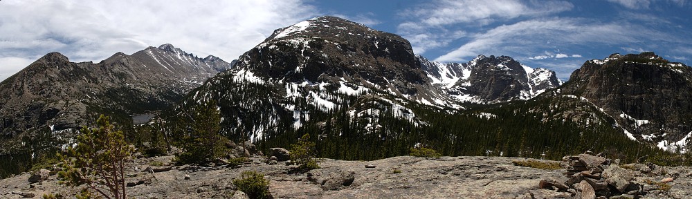
At the summit of Arapaho Pass, on the Continental Divide, it was as windy as I expected. I had to take my cap off lest it be blown away. The trail down is in very good shape. It’s almost entirely on a steep grassy slope – no scree, no talus. It’s not as steep as I expected, and the footing is generally good with only a short stretch of slippy stuff. It only took me half an hour to get from the top to the lake.
I really like Caribou Lake. It’s surrounded almost entirely by high, rugged mountain peaks. The forest it’s in is sparse, and its shores are grassy, providing wide-open views. The water, like most lakes along the Divide, is crystal clear. While eating my picnic lunch, sitting on a rock thirty yards upslope from the water, I could see fish swimming.
I arrived at the lake less than three hours after leaving the car. It was a little early for lunch, but I ate anyway. I ate about half my food, with the idea of having second lunch at the mine on the way back.
When I got to the lake, I thought I heard voices. I often think I hear voices, but that tends to happen to me in places I don’t expect to find other people. In this case, I did hear voices. I never spotted the other people, but I think they were climbing fairly high up a scree pile. At one point, I heard rockfall. It lasted several seconds, perhaps starting with a single rock but ending more like scree. The voices seemed to come from the same direction, but I never did spot anybody in that direction.
I didn’t circumnavigate the lake, but I did explore the north shore. I spotted several vintages of moose poo, and there were moose tracks on the lake bed near the outlet. I didn’t spot any moose, but they’re regular visitors here.
I stayed there for about an hour. I didn’t spend much time thinking about the hike back up the mountain, but I couldn’t help but notice it’s on the only grassy slope that goes all the way to the top. The trail looks to be perfectly laid out. The prospect of the hike out literally hangs over your head the whole time you’re there. But I had a plan.
I had a plan, but did I have the discipline? The plan was to never look up. I paused several times to take in the view below me, but I didn’t want to look up and see how much farther I had to go. I kept my vision on the ten or fifteen yards of trail between the toes of my boots and the brim of my cap. My discipline held, for the most part. On the hike down, I made a mental note that a rock outcrop the trail passes is quite close to the top. The first time I looked up, I was much closer to the outcrop than I expected.
It took me fifty minutes to make the climb, so a pretty good pace given the terrain. At the top, it was noticeably windier than it was a couple of hours ago. I took that peek at the outcrop after I heard the peal of thunder in the distance. Storm clouds were building. It looked quite dark indeed on the west side of Caribou Pass. I hoped it wouldn’t start raining until I was at the top.
At the top, I was greeted not only by the increased wind but also by the sight of storm clouds wrapped around Mount Jasper. I had barely gotten a couple of hundred yards down the trail, far enough below the pass that the wind wasn’t so bad, when it started to precipitate. It started, as it often does, with graupel. That was quickly replaced by a steady, cold rain. I began to wonder if the weather would cooperate with my plans for second lunch at the mine. There looked to be some blue sky to the west of this squall, so I remained confident.


The storm did pass soon enough. As it headed east, it continued to grow, dousing the valley below pretty good, but I was back in bright sunshine before getting back to the mine. I ran into a couple there, who told me they’d been watching a moose for the last half hour. They asked me how far up the trail the waterfall is. There is no waterfall up the trail from here. I mentioned the one before the Diamond Lake junction, across the valley, and said that with so little water running, it wasn’t obvious. “Ah, yes, that’s probably the waterfall we’re thinking of.” They wandered off, and I ate, and I never did spot the moose.
A bit later, I came across a backpacker. He said he hadn’t decided yet whether he’d camp at Lake Dorothy or the lower Neva Lake. I asked if he’d been to Dorothy before; it’s pretty desolate. He’d been there before, and he agreed. I think it would make for an incredibly windy night.
When I reached the Wilderness boundary, I met three young women sitting on a large boulder, lounging and chatting. They asked what there was to see on this trail. “Is there anything within twenty minutes?” No, nothing on this trail within twenty minutes. I didn’t have the heart to tell them I’d been hiking for seven hours. The boundary is only about a quarter of a mile from the parking lot.
I highly recommend Caribou Lake. It’s less than a ten-mile round trip, and the climb back up to the pass wasn’t the slog I envisioned. The lake is quite scenic, and there are some very nice campsites there. I will almost certainly make a return visit. Next time, I’ll make the short side-trip to a small, unnamed pond a quarter mile to the west.
It occurs to me that it might be a pleasant backpacking trip to hike in from Fourth of July trailhead, camp at the lake, and hike out to Monarch Lake.


