Upper Diamond Lake

This is my second trip up this valley. Back in early July, I came up here thinking I’d be able to get to the upper lake, but there was too much snow. Yes, it was silly of me to think I’d be able to hike above 11,000′ that early in the season. One nice thing about not getting to where I wanted to go is that it’s a built-in excuse to make another trip.

Friday, September 1

Rather than repeat myself, I’ll begin at Diamond Lake. (There is no shuttle to the trailhead, so I’ll note that on a Friday before a holiday weekend, there were still a few parking spots available at 7:30 am.)

There are more like four Diamond Lakes than two. In addition to Diamond Lake (10,960′) and Upper Diamond Lake (11,732′), there are two more. One is at 11,359′ and a much shallower one lies at 11,518′. I’m reasonably certain this second one never dries out, but it’s a close call.

When I’m hiking on a well-maintained trail, I generally don’t use trek poles. I carry them with me, strapped to my daypack. When I got to Diamond Lake, I broke out the poles only to get hit with glitch number one of the day. One of the nuts on the cams had come off. I couldn’t extend the pole to anything like a usable length. Oh well. No poles today. I hope that’s not going to be a problem.

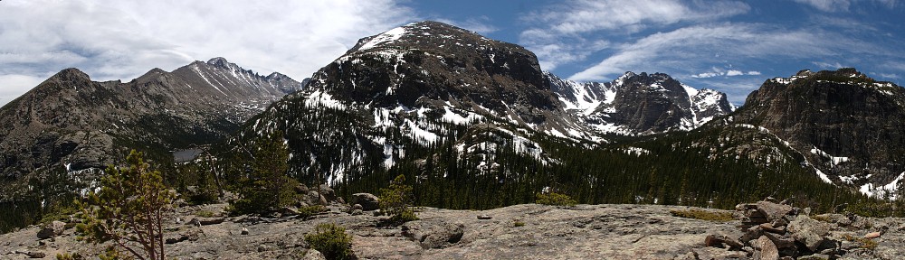
To get to Upper Diamond Lake from Diamond Lake, continue to follow the trail that skirts the lake on its northern shore. I followed it all the way to the inlet stream. The trail climbs steeply for a while beside the burbling stream on a grassy slope. After a bit, I reached a T intersection. This surprised me a bit. On the hike back down, I didn’t even see this intersection and ended up at Diamond Lake a fair distance farther east than where I left the lake.

At one point, the trail seems to terminate right up against a giant rock. I saw that some hikers had gone around the rock to the right, so that’s what I did. Circling above the rock, I found the trail again. At the foot of the rock, there’s a “crack” there that is easily climbed. I just didn’t look closely enough.

Not long after this, we get to the southernmost of the lakes. The trail goes right down to the water. This is ideal if you’re ending your hike here, but not so ideal if you are continuing to the upper lake. This is more or less the end of the trail.

We’re above treeline by now, so the lack of a trail isn’t that big of a deal. From here on out, it’s fairly easy to see where you need to go, and there is enough hiking traffic that occasionally you come across some grass that’s clearly been walked through. I also spotted a cairn here and there, but these cairns are more of a confirmation that I’m going in the right direction than they signal a clear route.

The final approach to the upper lake is across a mix of narrow grassy slopes and boulders/talus. The lake is stark – a drop of water at the head of a narrow, rocky canyon. I didn’t stay there long. The wind, while not fierce, was steady.

It was only 10:30 (so, a bit less than a three-hour hike from the trailhead) and I wasn’t yet ready for lunch. I had a quick snack and headed back down, thinking I could find a scenic spot for lunch back at the lake where the trail ends. This was a much shorter stay at my destination than usual. It wasn’t that I was rushed for time, or that I didn’t find the lake very scenic. I just didn’t feel like sitting in the wind for very long, and, frankly, I enjoyed the hike between the lakes as much as I did the lake itself.

I took another break at the lower lake to slurp down a tasty Palisade peach.

I hadn’t seen another hiker since I first arrived at the lower lake. On the hike out, there was quite a bit of traffic on the trail. A short distance before reaching the junction with the Arapaho Pass trail, hikers told me to be on the lookout for a moose. I can’t tell you how often hikers tell me to be on the lookout for moose that I never see. This time, though, I spotted her. She was sitting comfortably in the shade only about twenty feet off the trail, chewing her cud.

My second glitch of the day happened about ten minutes from the trailhead. I’m the first to admit I’m a bit of a clumsy oaf. Last week, I mentioned that I fell down four times. When I’m bushwhacking through dense forest, this doesn’t bother me much. It seems like tree limbs make a sport of grabbing my boots and pulling me off-balance. It goes with the territory.

On the trail, however, I expect to be able to keep on my feet. I don’t know what happened, but I took a mighty fall. I managed to break my fall with my hands, then sort of half-roll. I got a little bit of road rash on my left hand, which is annoying. But I landed on that hand pretty hard and it’s quite swollen and a bit discolored. I popped a couple of ibuprofen and continued back to the car. I have a couple of other bruises – my left upper arm just below the shoulder and my left leg, just above the knee.

This is the second time I’ve fallen on the trail. The first was about ten years ago. I scraped my arm pretty well and was covered in blood. I still carry about a six-inch scar from that one. Very little blood today. In addition to the sore, bruised, swollen left hand, I did a bit of damage to the GoPro. I carry it in the left front pocket of my pants. The selfie-stick/tripod it’s mounted on is a bit too long to fit in the pocket, so the camera sticks out. I landed right on top of the camera before my half-roll. No damage to the camera, but I did break the clear lens cap.

At least nobody witnessed my oafishness.

But for my clumsiness, it was an ideal day.

Spruce Canyon Addendum

In my write-up of last week’s backpacking trip, I somehow completely forgot to mention the toad.

As long as I’ve been hiking to Spruce Lake, they’ve had notices prominently posted that the wetlands on the east side of the lake are closed. That includes the shallow part of the lake where I saw the male and female moose sniffing each other and the marshy area from there to the trail. This area is closed to protect the breeding habitat for the boreal toad, which is classified as endangered by the state of Colorado.

I’ve never once seen nor heard any toads around here. I had no idea any toads or frogs lived in this part of the world, it being a few hundred feet short of 10,000′ above sea level and pretty much frozen solid a few months every year.

Well, this trip I finally spotted one. It wasn’t anywhere near the closure, but on one of the few stretches of bushwhacking we did on our way up to Loomis Lake when we lost the trail. The little guy (or gal) hopped right in front of me. I snapped a couple of photos, but he didn’t stand still for his portrait and none of them turned out. Still, it’s not every day one gets to see an endangered species in the wild.

Diamond Lake

Mount Jasper rises to nearly thirteen thousand feet on the Continental Divide in the Indian Peaks Wilderness. One might think of it as being shaped somewhat like a starfish as it has five major ridges emanating from it. Two of these are situated on a nearly east-west axis. Between these two arms is a drainage that contains Diamond Lake, Upper Diamond Lake, and a couple of smaller unnamed ponds.

In addition to Mount Jasper, there is also Jasper Lake, an operating reservoir in the next drainage to the south of Diamond Lake.

There’s a well-traveled trail from the Fourth of July trailhead to Diamond Lake, a popular camping destination. There is no official trail from Diamond Lake to Upper Diamond Lake, but a little research yields at least two routes from Diamond Lake to Upper Diamond Lake. For maps, my go-to resource is Caltopo.com. They indicate a trail from the westernmost shore of Diamond Lake up an inlet, passing a pond before climbing to the north. ProTrails, on the other hand, suggests heading more or less due west from a meadow reached just prior to the trail actually reaching Diamond Lake.

Diamond Lake, like most of the other alpine lakes in Indian Peaks, sits fairly high up at a shade under 12,000′. Upper Diamond Lake is another 800′ or so higher. Because we have had such a wet spring, I expect the forest sections of trail below Diamond Lake might still be covered with snow. Certainly, no matter what route I might take to Upper Diamond Lake, I expect to find quite a bit of snow. At this time of year, even without higher-than-usual snowfall, microspikes would be required.

Monday, July 3

Both the Hessie trailhead and the Fourth of July trailhead are served by the same road, which becomes a dirt road just after passing through the town of Eldora. I’ve only been up this road a handful of times before today, and never on a weekend. Yes, today is a Monday, but with a holiday tomorrow, I expect it to be busier than a typical weekday. I was correct.

A sort of temporary entrance station was set up on the road at the entrance to Nederland High School. I arrived here at 7:45. They already had the shuttle bus for the Hessie trailhead operating. I was second in a line of four vehicles; we all were going to the Fourth of July trailhead at the end of the road. The fellow working the station got on the radio with a ranger at the trailhead to see how many of us could proceed. We were the last four cars allowed up the road. We had to wait a few minutes for the shuttle bus to return because the road is narrow.

It appears that sections of the road have been recently graded. Other sections are quite rough. Four-wheel drive isn’t required, but a fair amount of ground clearance is. Almost all the vehicles in the parking lot at the trailhead were SUVs and 4x4s, but there were a couple of compact cars.

When I arrived at the parking lot, I was afraid the ranger had miscounted. As I was approaching the lot, she was headed down the road in her truck. The spot I parked in was right up against a no-parking sign and I was concerned that overzealous enforcement might result in a ticket. One of the cars behind me took a similarly marginal spot across from me. I never did see where the fourth car parked.

The morning was beautiful, with clear deep blue skies, calm, with a temperature of just under 60 according to the car’s thermometer. Outstanding hiking weather.

The trail from the parking lot climbs about 600′ to the junction with the Diamond Lake trail. There is one pair of switchbacks in the middle of this climb, which traverses an increasingly steep slope. After the switchbacks, there are a few places where you get a nice view of the opposite side of the valley. Prominent in these views is the outlet stream from Diamond Lake, which cascades more than 400′. The sound of the falling water is constant accompaniment on this first mile or so of trail.

A bit more than a mile from the trailhead is a junction: to the left is Diamond Lake; to the right, the Fourth of July mine and trails to Arapaho Pass, Lake Dorothy, and South Arapaho Peak.

Heading left, the trail descends about three hundred feet before climbing the other side of the valley. There are a few stream crossings, with at least one of the bridges in need of some repair. As I expected, there is snow on the trail in places that don’t get much sunshine.

Just before reaching the lake, the trail levels off quite a bit and dumps the hiker on the east end of a large meadow. This early in the season, only the yellow flowers that flourish in marshy ground are in abundance. Perhaps as soon as a few days from now, flowers sporting all the colors in the rainbow will carpet the place.

Here, today, the trail is still covered in snow. A small rivulet is carving a little canyon through the snow. Snow melts from the bottom, and you can easily see that the trail crosses a snow bridge. It’s hard to judge just how thick the bridge is, but when I crossed it in the morning it was twelve or fifteen feet wide. Still, I was careful to not step where I thought it was thinnest. On the way back, a couple of hours later, the bridge was nearly gone, the snow is melting so quickly.

One possible route to Upper Diamond Lake heads across this meadow and up the slope that’s northwest of the lake. I didn’t see an obvious “easy” route – the meadow is more like a marsh right now, and the slope still held quite a bit of snow. It might be a good route in August or September, but I wasn’t going to head up that way.

When I got to the shore of Diamond Lake, I met a couple of hikers. I asked them if they had tried to get to the upper lake. I showed them my map while we discussed it. They weren’t familiar with the route suggested by ProTrails but did make an attempt to go the way that’s marked on the CalTopo map. They didn’t get too far: it was too snowy for them. Here, I decided to skip any attempt to reach the upper lake. The hike so far was a pleasant one, and there’s no reason not to come back when there’s less snow on the ground and the meadows aren’t marshes.

I walked along the northern shore of the lake. It’s grassy. Well, it’s grassy under the snow. I was a bit surprised at how much snow was still on the ground here, given that it’s in direct sunlight much of the day. It’s three, four, even five feet thick and stretches along the entire north shore of the lake. There are a few rocks along the shore that might make good picnic spots, but I preferred the somewhat larger rocks right along the trail.

The summit of Mount Jasper isn’t visible from here, just one of its eastern ridges. Here, much closer to the Divide than the parking lot, it was naturally a bit breezier. No mirror-like lake surface, but not so windy as to make whitecaps.

I didn’t count the number of campsites. Diamond Lake isn’t quite as busy as Lost Lake, but it’s still quite popular. On the hike and at the lake, I never went more than a few minutes without encountering other hikers. That said, my picnic spot had the illusion of solitude. Other than the few people who passed my picnic spot on the trail, I only noticed a couple of hikers who were circumnavigating the lake.

On the hike out, I stopped for a break where a stream crosses the trail. There’s no bridge here, hikers just step from rock to rock. With the water running high this time of year, it can be a bit fraught. While I was eating my grapes, I watched two couples make the crossing. The first couple had an infant strapped to mom. They made it easily. The second was a bit more tentative. She went first, he stood by getting her crossing on video. She nearly tripped. I told her that if she had tripped, he’d have gotten it on video. “Good thing I didn’t trip!”

A bit later, I came across a group of five or six backpackers. They were headed up to Lake Dorothy. They’d never been there before. I described the lake and its environs and jokingly said I hoped none of them intended on sleeping in hammocks as the lake is surrounded by tundra.

It was a gorgeous day for a hike. The weather was outstanding. I was never bothered by mosquitoes. Although I didn’t reach my ultimate destination, I’m not disappointed. All in all, it was another beautiful day in the neighborhood.

A final note: I overcame one of last week‘s disappointments. It seemed odd (but not out of the ordinary) for a new version of a product to remove a feature of an older version. In this case, though, it was simply a change in the defaults. I can still take individual photos for my time-lapse, and edit them to my heart’s content.

timetableUpDown
Trailhead8:37am2:19 pm
IPW Boundary8:48 am2:00 pm
Diamond Lake trail jct9:16 am1:14 pm
Diamond Lake10:14 am11:48 am

More photos can be found here.