Saturday, October 6
Two lakes sit due south of Mount Neva, a few yards east of the Continental Divide, at nearly 12,000′ above sea level. I’ve been wanting to hike there for a few weeks but couldn’t fit it into the schedule. It’s getting late enough in the season that if I don’t do it now, I won’t do it this year.
I talked Chad into going with me. The last time I took him off trail, we traversed a steep forested hillside that made him quite uncomfortable. And early in that hike, he tweaked his ankle a bit. He didn’t have a great time.
So I was pleasantly surprised he agreed to go on a hike I described as sunny but cold, with winds that might drive us from the lakes within minutes, and to get there, we’d have two hours off the trail over a route that ProTrails describes as marshy with a steep wall at the end.
We left my place at seven. I figured the trailhead wouldn’t be as busy as it is in August. It was a calculated risk, and I had no Plan B. Generally I reach the high school before the rangers are staffing their station. Today we arrived just as the ranger put out the “FULL” sign for the Fourth of July trailhead.
He told us that there may still be parking available there. The ranger up at the trailhead was now on her way down with a count of available parking. We were directed to park next to an orange cone in the school parking lot, first in line for any empty spots. We waited maybe fifteen minutes before being told to head on up. Next in line behind us was a big Audi sedan. It’s a rough road with lots of holes and exposed rocks. Three or four cars later was a BMW sedan. That those guys got those cars up there indicates you can drive damn near anything up there if you’re so inclined.
Before shutting off the car, I checked the temperature: 28 degrees F.
To reach the lakes, we headed up the Arapaho Pass trail to the derelict mine and the junction with the trail that climbs the flank of South Arapaho Peak. It’s a two-mile hike from the trailhead, rising about 1100′ at a fairly constant grade. It took us an hour. From the trail junction, we’d descend a couple hundred feet to the floor of the valley. Chad was glad to be done with the relentless trail.
We’re pretty much right at treeline when we leave the trail. The trees are in clumps, fairly easy to skirt. Any flat spaces between the trees and along the stream are normally boggy and marshy, but this late in the season, everything is dry. Well, almost everything. We do come across a few bogs, but it’ll never be any drier than it is today. We followed a number of game trails that appeared and faded out at the edge of a dry marsh or a small talus field. Regardless, navigation is as easy as it gets with these expansive views.
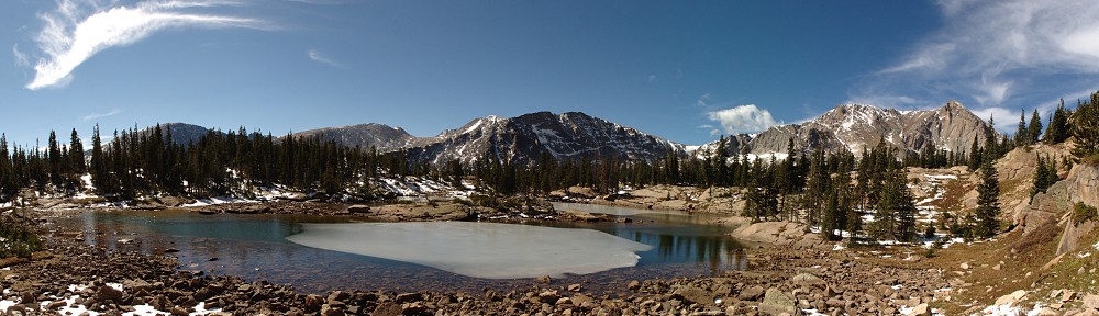
For about a mile above our stream crossing, we gain only about three hundred feet. It’s a pleasant, leisurely stroll. The sun is shining brightly in a deep cobalt sky with a gentle breeze. It has snowed here, lightly, a couple of times over the last several days. A thin dusting of snow clings to the high, steep, shady, northern mountainside. Where we’re walking, there are occasional spots of snow in the shade of a bush or rock. One pool we passed had a very thin sheet of ice on it. It was nearly invisible. I gently pushed on it. Not hard enough to crack it, but I did make some water rise through a few silver dollar-sized holes at the other end of the ice. Pretty cool.
Being off-trail, I expected not to see any other hikers. Just before we came to ProTrails’ “steep wall” below the lakes, we spotted three hikers with a dog working their way up the valley, still on the other side of the stream. They passed us pretty quickly, they were moving at a pretty good clip. We had a brief chat as to the best route. This was their first trip to these lakes, too. I said we were going to try to make use of any grassy ramps a bit to the left of the lakes to avoid the steep talus. This would take us to the upper lake first, putting us on its southeastern shore.
We arrived at the upper lake pretty much on schedule. We found a nice spot for our picnic not too close to the other hikers, whose dog ran over to greet us when we appeared. We had a nice view of Mount Neva. There was still not a cloud in the sky, and the winds were about as calm as one can expect beneath the Divide. I brought beers. I had a blood orange blonde, Chad had the lager.
After the other group left, Chad spotted a couple of hikers descending a ravine from the ridgeline between Mount Neva and Mount Jasper. There’s a route from Arapaho Pass that summits Neva and comes down here. Not long after those two guys, wearing shorts and lightweight shoes, disappeared down the outlet of the lake we saw two more hikers mid-descent. Too steep for me, I think.
The upper lake looks to already have drained two feet below its high-water mark, judging from the bathtub ring. The outlet is high and dry. A few yards below the lake, following the dry outlet we came to running water: the upper lake is draining from here. It’s a pretty strong flow. I’d guess it’s eight or ten feet of elevation below the surface of the lake. This drain is surrounded by tufts of grass. The water flows gently to a small pond that then drains into the lower lake. The lower lake is still full.
Leaving the lower lake at its outlet, we were at the top of a large, steep talus field. The grassy ramps we came up on are quite a ways to our right. We worked our way down diagonally, crossing more talus than is to my liking.


Navigation back across the valley and up to the trail is, again, dead simple. The trail we’re heading toward is a plainly visible slash across the mountain ahead of us. Again, we gained and lost social trails. A few times, I saw the footprints of the hikers with the lightweight footwear.
After crossing the stream, we needed to climb about two hundred feet to gain the trail. Getting near the end, I found a faint game trail. We followed it for a short while, but I decided I wanted to climb faster and took a more direct route. We stopped for a short break when we got to the trail. I figured we were between the mine and the junction. We discussed whether we wanted to head up to the mine or not. We decided not.
This was a good choice. It turns out we were above the mine and didn’t need to make a side trip to get there. Had we made the side trip, we’d have gone the wrong way.
When I was here before, I wanted to get a picture of the vertical mine shaft. There was no barrier around it. I’m smart enough to go nowhere near the slippery-looking edge, but I could imagine coming across it in the dark or in bad weather. Today I have my GoPro on a stick. Perhaps I could get a video looking down into the black hole.
It was not to be. They have somehow managed to fill the hole with dirt and rocks. I imagine they must have had to somehow put a plug in it and cover the plug with dirt. This was a pretty deep shaft and filling it up is out of the question. This trail gets quite a bit of traffic. I’m surprised they didn’t plug the shaft before now.
It was a great hike. We couldn’t have had better weather. The views were fantastic