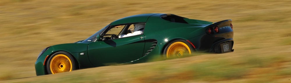
Clayton Lake

Imagine your left hand, palm up. The hikes in the James Peak Wilderness correspond roughly to your fingers: Rogers Pass Lake and Heart Lake would be on your thumb and Lower and Upper Forest Lakes your pinky. Clayton Lake, then, as well as the two Iceberg Lakes, would correspond to your index finger.

Back before James Peak Wilderness became part of the National Wilderness Preservation System in 2002, there were trails serving the lakes on each of your fingers. The trail to Clayton Lake, though, was “abandoned” about thirty years ago. (The trail to Arapaho Lakes was similarly abandoned a bit more recently.) According to various online resources, though, the trail still gets quite a bit of use. All these sources say the same thing: just follow the creek straight up the hill. Descriptions of this former trail are all very similar: “The creek and trail funnel through a rock-bound gulch with little room to maneuver.” “That last part was pretty hard but really cool.” “There is a section that is a bit of a steep scramble. Used my hands quite a bit through that section.” And there’s this one: “I read all the comments and they said ‘It’s hard to see the trail as it’s not maintained.’ No, the trail just completely doesn’t exist at all. I attempted and got completely lost. It was quite scary and will never do it again.”

A couple of summers ago, I ran into a volunteer and quizzed him about reaching Clayton Lake. He suggested that it’s easier to get there by going up the Crater Lakes trail to about 9400′ or 9500′ elevation, then striking cross-country from there. On my hike to Crater Lakes a bit after that discussion had me thinking I knew where I should leave the trail. But it’s an inexact science. Satellite photos aren’t much help, as the area is fairly thick forest. But it does seem that this route avoids climbing straight up a steep slope. I was willing to give it a shot.

Ideally, I’d like to reach the two Iceberg Lakes as well, but I’m not confident I can do all three on a day hike. If I can’t collect the Icebergs in a day hike, I’ll need to backpack in and spend a night. I’m not confident that the “straight up the stream” route, including “steep scrambles” is something I want to try with a full pack. Perhaps the volunteer’s route is better suited. Well, there’s one way to find out.

Monday, July 10

I arrived at the trailhead parking lot at about 8 am. The road is in good shape right now and is set to improve as it is currently being graded. It’s about eleven miles of dirt road to reach the parking lot, but anything short of a low-slung sports car should have no trouble navigating it. I was a bit surprised to see only about a dozen cars in the lot, maybe half of which belong to backpackers not yet back from their destinations.

At the trailhead, there used to be a sign-in sheet where all hikers were expected to list the date, number in the group, their destination, and how long they’d be on the trail. This logbook is no longer there; at least it wasn’t there today.

It took me an hour and ten minutes to reach the trail to Crater Lakes. I hiked up this trail for about forty-five minutes, periodically checking the elevation with my phone. I was at more or less the correct elevation, I figured, so off the trail I went. Going was fairly easy at first, not too much deadfall and the terrain I was crossing was fairly level.

My plan was to avoid making any steep climbs, heading west or southwest and climbing as I went. Before long, I came across a small stream. I wasn’t expecting to reach water until I got to the stream that is the outlet from Clayton Lake, but it didn’t seem like this stream (actually three or four small streams braiding their way down the slope) carried enough water to be Clayton’s outlet. Nonetheless, I headed uphill following the stream.

The forest here was getting more difficult to traverse, getting steeper and having more fallen trees. I crossed the stream half a dozen times as I climbed, always searching for the easiest route. At one point, I climbed a bit where I knew I’d have difficulty going down. I try to avoid going up slopes I think will cause me difficulty when going down, but I figured (if I managed to retrace my steps) that I could make a small detour if need be.

After following the stream for a while, I found the source of my little stream. I was standing at the edge of a marshy meadow. Rather than slog my way across it, risking wet feet, I skirted the meadow. On the other side of the meadow, I found a grassy ramp, somewhat steep, that climbed alongside giant granite slabs. Above me looked to be the low spot of a saddle. Perhaps I was getting close to the lake.

Topping this slope I found myself back in the woods. With the ground much more level, the walking was easy again. I kept climbing, always looking to find the low spot on the saddle. Continuing west or southwest, I expected to come across the outlet stream eventually. Passing through a small band of trees, I found myself on another grassy slope, walking slightly downhill, and could now see the lake. I had arrived on the northern shore of Clayton Lake.

The lake is mostly surrounded by forest. I’m a big fan of finding a nice rock to sit on for my picnic. Ideally, said rock would be in the sun, out of the wind, and close to the water. In search of such a rock, I worked my way around to the outlet. There’s still quite a bit of snow here and I easily crossed a snowdrift that hid the outlet. I saw no sign of the old trail, but there was a social trail that edged the north shore. Finding mostly snow on the south shore, I abandoned my search in this direction and doubled back.

From the time I left the Crater Lakes trail until I returned to the trail about three hours later, the only sign I saw of any other person was a boot print in the mud on the little social trail that skirted the north shore.

I wandered the north shore for about fifteen minutes before I found my picnic rock, considerably farther from the water than I wanted to be, but so it goes. Just before I got off the Crater Lakes trail, I met a couple of backpackers on their way back to the trailhead. I asked if they’d seen any game. “Just mosquitoes!” Mosquitoes aren’t big game, but even on my picnic rock, out of the trees and in a light breeze, mosquitoes buzzed me constantly. I’d sprayed some mosquito repellent on me back at the car, so I was happy that it seemed to still be working. They buzzed, but they never landed.

After relaxing for a bit more than half an hour, I started to retrace my steps back down the mountain. I’ve found that route finding is easier on the way down than on the way up: the value of the high ground. I quickly found a game trail. A few yards down the trail, I felt that I should have been heading more to my left, but I stayed on this game trail for a bit longer. It seemed to be well-traveled, punctuated as it was with pellets. Before long, I decided to backtrack, forgoing the trail for the untracked ramp I climbed earlier.

Back at the marshy meadow that was the source of the small stream I followed uphill for a while this morning, I managed to find another game trail. At no time on my climb to Clayton Lake did I find a game trail, but from this trail I found just below my marshy meadow all the way back to the Crater Lakes trail, I managed to go from one game trail to another.

My experience with game trails is that they’re nice when they’re nice, but they often stop being nice in the most inconvenient places. Today, every time deadfall blocked the trail, I was able to find its continuance a few yards later. Game trails generally aren’t singular things: they’re all part of a network. From the marshy meadow back to the trail, whenever there was a choice of direction, I kept to the left and downhill. I figured I couldn’t go too far left – I’d eventually reach the Crater Lakes trail. My only concern was not finding myself at the top of some rock outcrop that I couldn’t get down.

These game trails kept me out of trouble: I’m pretty sure the deer and elk aren’t interested in getting stuck on some random outcrop and they don’t want to go up or down anything too steep. As I said, this game trail took me right to the Crater Lakes trail. I made a note of where it is. On the hike up the Crater Lakes trail, there’s a large coil of cable just off the trail. I have no idea why it’s there, but it’s been there for years. I figure my game trail is something like three hundred yards past the cable, very near a large sawn tree trunk.

Given that my route back from Clayton Lake was so easy, I think I’ll return on a backpacking trip. Even having found this easy route, I think Iceberg Lakes are too far for me to reach on a day hike. Hiking cross-country with no trail is a lot more time-consuming and more strenuous. But I’m confident I can backpack up this route and by spending one night at Clayton Lake, I should be able to collect both Iceberg Lakes.

When I’m hiking on a trail, my mind often goes into auto-pilot mode. I just keep putting one foot in front of the other until I get to some navigation point. My feet stay on the trail, but my mind wanders. Bushwacking, though, is another story. My mind is intensely focused on the task at hand. Bushwacking is a bit like solving a maze that has more than one solution. At any given point, I’m looking for where I should go next. How do I get around this jumble of deadfall? I want to go there, but what’s the best way? Once I get there, where do I go next? My mind does not wander. I’m not thinking about some TV show, I don’t have some song earworming into my brain, I’m not bothered by what some idiot said on the internet, and I’m not worrying about rent, or debt, or thinking about what I might do tomorrow. I’m in the here and now, completely focused on the moment. It is glorious.

LocationUpDown
Trailhead8:10 am2:30 pm
Forest Lake jct8:46 am1:57 pm
Crater Lake jct9:20 am1:27 pm
Left trail/returned to trail9:54 am12:43 pm
Clayton Lake11:00 am11:57 am

Diamond Lake

Mount Jasper rises to nearly thirteen thousand feet on the Continental Divide in the Indian Peaks Wilderness. One might think of it as being shaped somewhat like a starfish as it has five major ridges emanating from it. Two of these are situated on a nearly east-west axis. Between these two arms is a drainage that contains Diamond Lake, Upper Diamond Lake, and a couple of smaller unnamed ponds.

In addition to Mount Jasper, there is also Jasper Lake, an operating reservoir in the next drainage to the south of Diamond Lake.

There’s a well-traveled trail from the Fourth of July trailhead to Diamond Lake, a popular camping destination. There is no official trail from Diamond Lake to Upper Diamond Lake, but a little research yields at least two routes from Diamond Lake to Upper Diamond Lake. For maps, my go-to resource is Caltopo.com. They indicate a trail from the westernmost shore of Diamond Lake up an inlet, passing a pond before climbing to the north. ProTrails, on the other hand, suggests heading more or less due west from a meadow reached just prior to the trail actually reaching Diamond Lake.

Diamond Lake, like most of the other alpine lakes in Indian Peaks, sits fairly high up at a shade under 12,000′. Upper Diamond Lake is another 800′ or so higher. Because we have had such a wet spring, I expect the forest sections of trail below Diamond Lake might still be covered with snow. Certainly, no matter what route I might take to Upper Diamond Lake, I expect to find quite a bit of snow. At this time of year, even without higher-than-usual snowfall, microspikes would be required.

Monday, July 3

Both the Hessie trailhead and the Fourth of July trailhead are served by the same road, which becomes a dirt road just after passing through the town of Eldora. I’ve only been up this road a handful of times before today, and never on a weekend. Yes, today is a Monday, but with a holiday tomorrow, I expect it to be busier than a typical weekday. I was correct.

A sort of temporary entrance station was set up on the road at the entrance to Nederland High School. I arrived here at 7:45. They already had the shuttle bus for the Hessie trailhead operating. I was second in a line of four vehicles; we all were going to the Fourth of July trailhead at the end of the road. The fellow working the station got on the radio with a ranger at the trailhead to see how many of us could proceed. We were the last four cars allowed up the road. We had to wait a few minutes for the shuttle bus to return because the road is narrow.

It appears that sections of the road have been recently graded. Other sections are quite rough. Four-wheel drive isn’t required, but a fair amount of ground clearance is. Almost all the vehicles in the parking lot at the trailhead were SUVs and 4x4s, but there were a couple of compact cars.

When I arrived at the parking lot, I was afraid the ranger had miscounted. As I was approaching the lot, she was headed down the road in her truck. The spot I parked in was right up against a no-parking sign and I was concerned that overzealous enforcement might result in a ticket. One of the cars behind me took a similarly marginal spot across from me. I never did see where the fourth car parked.

The morning was beautiful, with clear deep blue skies, calm, with a temperature of just under 60 according to the car’s thermometer. Outstanding hiking weather.

The trail from the parking lot climbs about 600′ to the junction with the Diamond Lake trail. There is one pair of switchbacks in the middle of this climb, which traverses an increasingly steep slope. After the switchbacks, there are a few places where you get a nice view of the opposite side of the valley. Prominent in these views is the outlet stream from Diamond Lake, which cascades more than 400′. The sound of the falling water is constant accompaniment on this first mile or so of trail.

A bit more than a mile from the trailhead is a junction: to the left is Diamond Lake; to the right, the Fourth of July mine and trails to Arapaho Pass, Lake Dorothy, and South Arapaho Peak.

Heading left, the trail descends about three hundred feet before climbing the other side of the valley. There are a few stream crossings, with at least one of the bridges in need of some repair. As I expected, there is snow on the trail in places that don’t get much sunshine.

Just before reaching the lake, the trail levels off quite a bit and dumps the hiker on the east end of a large meadow. This early in the season, only the yellow flowers that flourish in marshy ground are in abundance. Perhaps as soon as a few days from now, flowers sporting all the colors in the rainbow will carpet the place.

Here, today, the trail is still covered in snow. A small rivulet is carving a little canyon through the snow. Snow melts from the bottom, and you can easily see that the trail crosses a snow bridge. It’s hard to judge just how thick the bridge is, but when I crossed it in the morning it was twelve or fifteen feet wide. Still, I was careful to not step where I thought it was thinnest. On the way back, a couple of hours later, the bridge was nearly gone, the snow is melting so quickly.

One possible route to Upper Diamond Lake heads across this meadow and up the slope that’s northwest of the lake. I didn’t see an obvious “easy” route – the meadow is more like a marsh right now, and the slope still held quite a bit of snow. It might be a good route in August or September, but I wasn’t going to head up that way.

When I got to the shore of Diamond Lake, I met a couple of hikers. I asked them if they had tried to get to the upper lake. I showed them my map while we discussed it. They weren’t familiar with the route suggested by ProTrails but did make an attempt to go the way that’s marked on the CalTopo map. They didn’t get too far: it was too snowy for them. Here, I decided to skip any attempt to reach the upper lake. The hike so far was a pleasant one, and there’s no reason not to come back when there’s less snow on the ground and the meadows aren’t marshes.

I walked along the northern shore of the lake. It’s grassy. Well, it’s grassy under the snow. I was a bit surprised at how much snow was still on the ground here, given that it’s in direct sunlight much of the day. It’s three, four, even five feet thick and stretches along the entire north shore of the lake. There are a few rocks along the shore that might make good picnic spots, but I preferred the somewhat larger rocks right along the trail.

The summit of Mount Jasper isn’t visible from here, just one of its eastern ridges. Here, much closer to the Divide than the parking lot, it was naturally a bit breezier. No mirror-like lake surface, but not so windy as to make whitecaps.

I didn’t count the number of campsites. Diamond Lake isn’t quite as busy as Lost Lake, but it’s still quite popular. On the hike and at the lake, I never went more than a few minutes without encountering other hikers. That said, my picnic spot had the illusion of solitude. Other than the few people who passed my picnic spot on the trail, I only noticed a couple of hikers who were circumnavigating the lake.

On the hike out, I stopped for a break where a stream crosses the trail. There’s no bridge here, hikers just step from rock to rock. With the water running high this time of year, it can be a bit fraught. While I was eating my grapes, I watched two couples make the crossing. The first couple had an infant strapped to mom. They made it easily. The second was a bit more tentative. She went first, he stood by getting her crossing on video. She nearly tripped. I told her that if she had tripped, he’d have gotten it on video. “Good thing I didn’t trip!”

A bit later, I came across a group of five or six backpackers. They were headed up to Lake Dorothy. They’d never been there before. I described the lake and its environs and jokingly said I hoped none of them intended on sleeping in hammocks as the lake is surrounded by tundra.

It was a gorgeous day for a hike. The weather was outstanding. I was never bothered by mosquitoes. Although I didn’t reach my ultimate destination, I’m not disappointed. All in all, it was another beautiful day in the neighborhood.

A final note: I overcame one of last week‘s disappointments. It seemed odd (but not out of the ordinary) for a new version of a product to remove a feature of an older version. In this case, though, it was simply a change in the defaults. I can still take individual photos for my time-lapse, and edit them to my heart’s content.

timetableUpDown
Trailhead8:37am2:19 pm
IPW Boundary8:48 am2:00 pm
Diamond Lake trail jct9:16 am1:14 pm
Diamond Lake10:14 am11:48 am

More photos can be found here.

Lost Lake

Thursday, June 29

Aside from a short walk one day on my Atlanta trip back in April, I haven’t been hiking yet this year. It’s past time to rectify this.

Back in the depths of winter, I did a bit of map study and came up with a list of ten day hikes I might possibly make this year. Most of the hikes on this list are in the Indian Peaks Wilderness. One of them is Skyscraper Reservoir, which is reached via the Woodland Lake trail from the Hessie Trailhead.

Much of the lower part of the route is along the South Fork of Middle Boulder Creek. To get to the Woodland Lake trail, one must head north from this stream. On the map, there appear to be two options. The first is the trail I took last summer to reach Jasper Lake and Devils Thumb Lake. This trail runs parallel to another trail that connects the King Lake trail and the Woodland Lake trail. The two trails run on opposite sides of what I assume is Jasper Creek. The trails are never more than about a thousand feet apart, but neither trail is visible from the other. As I’ve already hiked the eastern one of these, I elected to take the western one.

This turned out to be a sound choice. There’s a spur trail connecting the two about a mile from Middle Boulder Creek. I assumed there’d be a bridge here to cross the creek. It doesn’t look like there ever was a bridge here. Many of the trails began as wagon tracks, and this crossing is simply a ford. Given the amount of snowpack the Indian Peaks received this year and the continued wet weather, the North Fork of Boulder Creek is flowing high and mighty. I’d probably be okay wading across it in August or September, but not today.

Part of the mile of trail between Middle Boulder Creek and the Woodland Lake trail can be challenging to follow. The trail gets a bit braided. It’s surprisingly easy to get off what should be the main trail onto something more like a game trail. I managed to do this hiking in both directions. It was more obvious on the way out. At one point, I knew I was on a trail I hadn’t been on earlier. I backtracked a bit but never did find where I went wrong.

Only about a quarter of a mile after the ford where the spur from the Jasper Lake trail, there’s a bridge that crosses the stream the trail is now following. To be more correct, the trail crosses the stream but the bridge is gone. Well, not “gone” so much as broken into pieces and lying in the middle of a raging torrent. It looks to me like this bridge has been out for a while, but I could be mistaken.

Again, given the flow of water, I wasn’t about to attempt a crossing. Clearly, I wouldn’t be reaching either Woodland Lake or Skyscraper Reservoir today. When I set out, I figured I might have time on the hike out to make a side trip to Lost Lake. Instead of a side trip, Lost Lake got promoted to today’s destination.

It’s only about a quarter of a mile from the main trail, up the spur to Lost Lake. The last few yards are the steepest. By the time I reached this steeper part, I’d already hiked about two and a half miles farther than anybody else here. I was powering my way up, huffing and puffing and sweating, when a downhill hiker felt the need to encourage me: “You’re already there!”

Lost Lake is a kidney-shaped body of water covering a bit less than five acres on the northern flank of Bryan Mountain, a non-descript peak topping out at less than 11,000′. There are nine campsites situated around the lake, and a trail (along with a network of social trails) circumnavigates the lake. The best view, in my opinion, is found on the eastern shore, looking a bit west of due north.

The trail guide says Lost Lake is a 2.7-mile round trip. I’m not sure if that’s the correct distance or not. If it’s measured from the trailhead, the hike is another half a mile each way. I’ve only ever seen one or two vehicles actually make it to the trailhead due to the deep water on the road that services it. Everybody else just parks along the main road. In any event, Lost Lake is the shortest hike from the Hessie trailhead and is therefore the busiest destination on the menu.

I stayed at the lake for a bit over an hour. There was a steady stream of hikers coming and going, and it looked to me like all the good shoreline resting spots were in constant use. At least a few of the folks didn’t seem to realize how well sound travels over water, and the other people there could clearly hear their conversation. I had my picnic lunch and relaxed, while other hikers fished or swam.

My first disappointment of the day was the washed-out bridge that stymied my hike to Skyscraper Reservoir. My second disappointment of the day was my peach. I should have realized it’s far too early in the season to get my favorite Palisade peaches, but when I bought them, they seemed ripe. I want my peach flesh soft, juicy, and sweet. Instead, it was crunchy like an apple; not very juicy, not terribly sweet, and only vaguely peach-flavored. So it goes.

While I ate and rested, I had my GoPro Max doing a timelapse. I should have played around with this camera before doing this. It doesn’t work at all like either of my older GoPros. With those, when I’m doing a timelapse, it snaps a still photo every two seconds (or whatever interval I want). After an hour or so, I’d have a couple of thousand stills that I can crop in whatever way I want. That allows me to make sure the image is not cockeyed, or to crop them in a way that simulates zooming or panning. Disappointment three is that the new camera outputs not a bunch of still photos, but a fully-formed 1080p video. My video editing tools allow me to do the pan/zoom/rotate thing, but I would lose quite a bit of resolution. Unless I figure out how to take a still photo every two seconds, I’ll have to continue using the older camera for time-lapse videos.

Shortly after leaving Lost Lake, the clouds started getting a bit threatening. By the time I made it back to the car, it had started to hail. The skies to the west didn’t look good at all. Perhaps it was a good thing that I couldn’t take my longer intended hike. I had my rain jacket with me, but I might very well have spent a few hours slogging through the rain.

Marigold Lake

Due east of Odessa Lake, on a small shelf two hundred feet up the north slope of Joe Mills Mountain, sits a small puddle of a lake. It has no inlet stream to fill it with snowmelt and no outlet stream to drain it. With an area of about a third of an acre, it’s not much larger than the suburban lot my house sits on.

I suspect it is rarely visited, being somewhat difficult to find. I’ve tried to reach it twice before, without success. The only reason I want to go there is to add it to the list of lakes I’ve been to. I admit that’s probably too much effort to reach a body of water not much more than a puddle that probably doesn’t even merit the designation of “lake”.

Chad told me he wanted to go on a hike so we agreed on a date and I made a plan. I decided we should circumambulate around Joe Mills Mountain as on my first attempt at Marigold. According to CalTopo, the saddle between Joe Mills Mountain and Mount Wuh was burned. Round Pond sits on that saddle. Based on what I saw on my Spruce Lake hike, I suspect the trees around the pond have survived. Why not find out? It doesn’t add any miles to the trip, but it does exchange trail miles for bushwhacking miles.

Saturday, October 22

The Park was very busy. The shuttle from the Park and Ride to Bear Lake was standing room only. We put boots on the trail at about 8:30.

It was a bit chilly. The forecast for the vicinity was “sunny and breezy, with a high of 46”. There were some thin clouds much of the day, but we could always see our shadows. In the woods, the wind is no big deal, and most of the day we’d be in the woods, so “sunny and breezy” sounds like a nice day.

An hour up the trail, we hit our departure point and headed cross-country. Our route would be to contour around Joe Mills Mountain at more or less 10,400′. From the trail to about the pond, the forest isn’t terribly dense and deadfall isn’t too bad, so the bushwhacking is a fairly pleasant stroll through the woods.

Before long, the ground in front of us started sloping down: we had reached the saddle, a bit west of it’s lowest point. We wandered around here for a short while looking for Round Pond but didn’t spot it. Frankly, it has a half-hearted search. I was more interested in getting to the burn. Missing Round Pond isn’t missing much.

The forest is denser on the north side of the mountain, and soon we’d need to traverse a fairly steep slope for a while, westbound to Marigold Lake. But first we started seeing burnt trees. Just individual trees here and there, all deadfall; burned with almost no damage to the surrounding forest. One was still standing: a hollow tree, like a chimney. After several of these we arrived at the edge of the burn scar.

I was expecting the edge to be “fuzzy”. Indistinct. Maybe a border of trees that didn’t ignite and kept their dead, red needles. But no. Green, apparently healthy trees directly adjacent to scorched earth: charred tree trunks standing like giant whiskers. The hillside won’t get shaved, but almost all those dead tree trunks will fall to the ground over the next several years.

It has been two years since the fire. Two summer growing seasons have passed. On my hike to Spruce Lake, the entire burn scar was carpeted with fireweed. Here, there were large areas where the ground is still black. I was surprised to find occasional piles of ash. I suspect they’re in dried puddles and the ash accumulated here. It’s bone dry now: disturb the frail crust and raise a bloom of ash.

On my hike to Spruce Lake, I noticed that the char on the trees is only a couple of millimeters thick, and it’s starting to flake off the dead wood. Here, I saw many interesting logs where the charred part has come off. The wood burned to different depths in random patterns, creating little topographic maps out of the tree rings.

As I said earlier, as we head west, the slope gets fairly steep for a while until we reach the bench that Marigold sits on. The forest isn’t burned here and is dense and there is much deadfall. It is a challenging route for about a third of a mile.

Chad had taken a little tumble shortly after we left the trail and his ankle was a bit tender. Now he mentioned that he was no longer enjoying the dinner he had so enjoyed last night. Then he asked me how steep I thought this slope was. And he was huffing and puffing.

We found a spot with a couple of flat rocks and a nice view and took a break. He told me later how uncomfortable he was. I had been thoughtless. Almost everyone I hike with is quite happy to go places I’m not comfortable going, so somehow I had the idea that, if I was okay going there, anyone would be okay with it. I know exactly what it’s like to find myself in terrain that makes me uncomfortable. It’s stressful. I should have gone over the route with Chad beforehand.

If we’ve navigated correctly, we’ll exit the steep, dense forest onto the bottom of a talus gully, right next to Marigold Lake. We came out a little bit below the lake but found it soon enough. After the dense forest, I was expecting that this pond would have no view. The view of Little Matterhorn from here is quite nice. In my plans, we were to take a nice break here, but unfortunately, there’s no place to sit. So we pressed on.

From Marigold Lake back to the trail, we’d go up a gully gaining about two hundred feet of elevation, then cross a fair amount of talus until we reached the Fern Lake trail about two-thirds of the way from Odessa Lake to the summit of the pass near Lake Helene. Although it’s a rather large talus field, the rocks are small and easy to cross and there are occasional outcroppings of grass.

Did I mention it was breezy? To now, it hadn’t been an issue. Sure, it was windy, the trees swayed quite a bit. On the forest floor, it wasn’t windy enough to disturb ashes. Crossing the talus was another matter. The wind was howling down from Ptarmigan Point unobstructed. I’d guess sustained winds were twenty miles per hour with gusts over forty or fifty. Several times, I was nearly blown over.

On the way, I came across the oddest thing. I found a solar-powered light. The kind with a stake on the end, so you can drive it into your lawn. Who would bring such a thing to the middle of a talus field? And leave it there? I packed it out. How long could it have been out here? The stickers on it were still intact. It came from WalMart.

Back on the trail, we reach the top of the pass, where the trail returns to the trees and out of the wind and it’s all downhill from here. We stopped for a break on a couple of nice, flat rocks in the sun on the lee side of a slope above what as late as August would be a small pond but is now dry ground.

Today’s beer was a repeat: Palisade Peach.

When we got back to Bear Lake, the line for the shuttle was pretty long. After the first bus loaded, it looked like there was more than a busful of people still in line in front of us. Somehow, we managed to get sardined onto the second bus. We didn’t even stop at the Glacier Gorge trailhead on the way down.

Traffic was bad all the way from the Park to my house. We were back to the car pretty much on my expected schedule, but by the time Chad dropped me off at home, it was half an hour later than expected. Traffic sucks.

In Summary

I enjoyed my day. I can finally cross Marigold off the list (or, more accurately, put it on the list). Marigold Lake had a nicer view than I expected, but I don’t think I’ll ever bother to return.

The time exploring the burned area was particularly rewarding. It won’t be like this for very long. The ash and black will soon be gone, and grass and wildflowers will soon be here. And I hope this will be the last fire in the Park for an extended period.

I’m sorry that I led Chad into a situation that he didn’t enjoy.

Spruce Lake

The East Troublesome fire was first reported on the afternoon of October 14, 2020, eighteen miles west of Rocky Mountain National Park. Nine days later, it jumped a mile and a half over the Continental Divide to Spruce Canyon. That same day, it jumped the mile-wide burn scar from the Fern Lake fire of 2012, ran past the Morraine Park campground and reached Beaver Brook.

The East Troublesom and Cameron Peak fires burned a bit less than ten percent. It’s more than ten if you add in the Fern Lake and Big Meadows fires, both in the last decade.

The thing to keep in mind is that wildfires are a natural part of the lifecycle of the forest. They provide for renewal and increase the diversity of plants and animals. However, we spent a century suppressing wildfires, and we’ve seen climate change contribute to beetle kill. There’s much more fuel in the forests now than is usual. And with increasing temperatures and drought conditions (climate change again), the fires we get burn much more intensely than ever before. Historically, fires were smaller and tended to burn in a haphazard pattern – a mosaic. Today’s fires tend to burn everything. They can create their own weather – when East Troublesome jumped highway 34, it had created winds of 150 miles per hour. The result: scorched earth.

Last week, the NPS posted on Instagram that they had just re-opened the Spruce Lake trail after some trail work. I don’t know how long the trail has been closed – it’s possible it’s been closed since the fire or was just closed for the duration of the work.

I’ve been to Spruce Lake four times, most recently in 2019 on a two-night stay with Gordon, in an attempt to visit the four lakes in upper Spruce Canyon. Although that wasn’t the most pleasant of hikes, I did enjoy the extended time I spent there. I watched a cow moose and her yearling calf for a good, long time.

I wanted to find out how badly burned the place is.

Friday, September 16

My timed-entry permit was for 6-8 am. I arrived at Fern Lake Road at about 7:15. The road was lined on both sides with parked cars. In the meadow right next to the road was a large herd of elk. A disproportionate number of people had serious glass on their cameras, lenses as long as my forearm. I’d guess those guys could count the hairs in the nose of the majestic bull facing them from about twenty yards away.

A few yards up the road, two bucks were grazing maybe six feet off the road. Nobody paid them any attention. I got a picture, though. I see does all the time, but not many bucks.

From the parking lot to a little bit past the Pool, I can’t say I noticed anything different from my last few hikes here. At the parking lot, I noticed that a couple of the tall aspen had been burned, but nothing else looked like it had burned since the Fern Lake fire.

After the Pool, though, it’s a different world.

It is now the end of the second growing season after the fire. When I hiked through the Big Meadows burn scar just weeks after the fire, pretty much everything was black. There wasn’t a blade of grass, not an insect, no birds. The tree trunks were black, the ground was black, many of the rocks on the trail were black.

Two seasons after East Troublesome is already quite different. The black is starting to fade. Plants are starting to cover the ground. Today I learned why fireweed, one of my favorite wildflowers, got its name. It’s mid-September, well past the prime time for wildflowers. But today I saw more flowers than on my last three or four hikes combined. Almost all of them were fireweed. In some places, fireweed must have made up 90% of the plants. It was everywhere.

The tree trunks, both those still standing, and new and old deadfall, are still black. I saw a number of tree trunks had been cut by trail crews in years past. Some of them were unburnt on the cut end. This showed me how deeply the tree trunks are burned. It’s not thick, and it’s starting to flake off many of the standing dead trunks.

Standing on the hillside, looking north to the Fern Lake fire scar, the difference is obvious. Those trees, burned ten years before, are brown. The fresh ones are all black. Eventually, they’ll all be gray and you’ll have to look at differences in live plants to tell which happened first. And it might not be obvious.

The trail zig-zags up a north-facing slope. This whole slope is burned, except along Fern Creek, where some forest survives. Away from the creek, total devastation. After the zig-zags, the trail straightens and heads southwest towards Fern Lake. The trail parallels Fern Creek, but not always closely. Where there was water on October 23, there is still life. I stopped at Fern Lake first, as it’s only about a hundred yards above the trail to Spruce.

The old cabin is gone, razed to the foundation, which is now covered in brown tarps. But most of the trees around and above the lake aren’t burned in the same way as those below. Those below are scorched trunks only. Above, the fire clearly wasn’t as hot. There are still some green, live trees mixed in. And the many of the dead ones still still have their brown needles.

The bridge across the outlet was undamaged, but the privy has been replaced with a brand new one. And I find it a bit amusing that the little restoration area between the trail and the lake survived. It’s not amusing that that bit survived: it’s right next to the water. It’s amusing that one of the few unburnt places is fenced off, with a sign saying to keep out.

The trail to Spruce Lake climbs over a ridge, gaining about two hundred feet on the Fern Creek side. This slope is all burned, but from the top of the ridge, or a bit past, to the wetlands adjacent to Spruce Lake, it alternates between burned and unburned. The recent trail work included rebuilding the bridge with a bogwalk across the outlet. There are a couple of other new bogwalks, too, but others survived (if a bit scorched).

Speaking of trail work, a substantial amount of work was done on the trail where it zig-zags up the slope. There are a couple of long sections where the trail is paved with rock. The width of the trail (about four feet) for lengths of sixty feet in one place and more than a hundred in another. Looks like it’ll last centuries.

Spruce Lake has less damage than Fern Lake. The campsites look undamaged. The privy survived, but just barely: a tree trunk two feet in front of the stool is scorched. The wetlands at the outlet didn’t seem to get burned at all. In fact, there’s an enormous amount of dead tree matter that’s been there for years – it’s all gray – that doesn’t have a black mark on it. I’m amazed it’s still there.

The forest above the lake, on the way to Loomis, looked undamaged except for a small area of “slightly” burned trees (still with needles) high on one slope. Seeing no fire damage on the way to Loomis and an intact forest to the north and west, I decided not to go any farther. More about this decision later.

I haven’t seen any big game since the buck by the side of the road. Before I set out this morning, I was concerned that there wouldn’t be any left in any of this area. I’d imagine any moose or other deer would survive if they could get to the lake. But if they did, is there enough left to keep them here? Although I didn’t lay eyes on any game, I was happy to spot fresh moose shit and deer shit.

After only a short break at Spruce, I headed back to Fern. The idea was to get a short time-lapse sequence there, then hike down to somewhere before Fern Falls to eat my lunch and get a longer sequence, prominently featuring the burnt tree trunks. But, as Helmuth von Moltke noted, “No battle plan survives contact with the enemy.”

The Fern Lake bit of the plan went off well. But the weather was turning. I packed up after only fifteen minutes, and a light rain started to fall a few minutes later. It didn’t take long before it was raining hard enough to convince me to don my waterproof shell. Naturally, as soon as I did, the rain stopped. But I wasn’t fooled and kept it on. The rain came and went until I reached Fern Falls.

I stopped there for a quick snack. The sun was shining again, and it was calm. I took the shell off but kept it handy. The skies looked pretty threatening – everything to the west was dark. I was lucky to have a few minutes of nice weather for my snack and didn’t expect that luck to continue. And, not long after leaving the falls, I had the jacket back on. I wanted to have my picnic, but not in the rain. I hoped I wouldn’t need to eat my picnic in the car.

By the time I was perhaps only a quarter of a mile from the car I decided to stop. The threatening clouds hadn’t moved down the canyon with me. The sun was shining. I found a nice place to sit next to the stream and had my lunch. It wasn’t until a family went by on the trail that I realized just how close to the car I was. They weren’t carrying their toddler, she was walking. Still, better a picnic here than in the car. In the car, I wouldn’t have drunk today’s beer (a returning favorite, Left Hand Brewing’s Wheels Gose ‘Round).

My picnic spot was a three-minute walk from the car.

Conclusions

When I got in the car, I figured I had a few options, depending on what I saw. I could just go to Spruce Lake. Or, if the fire above the lake was bad, I could go to Loomis to check on it. Or, if the fire was worse below the lake, I could contour around and take a look up Spruce Canyon. I took my squirrel-eaten poles with me, in case I went anywhere beyond Spruce Lake. Good plan!

But silly me didn’t bother to refresh his memory about the fire or to even look at the fire history on CalTopo. Had I done this, I would definitely have taken a peek up Spruce Canyon. Now I have an excuse to come back next July or so to put eyes on what I didn’t bother to look at this time.

You see, it occurs to me that, after the fire, another try on Rainbow Lake, Irene Lake, and Sprague Tarn might be considerably easier. Route finding would be much easier, and although the big deadfall will still be there, it should be substantially easier to navigate. I only managed half a mile an hour before, where I generally can manage twice that bushwhacking. It might be worth another shot.

It would mean another two-night stay at Spruce. There’s a privy there. We watched moose eating aquatic grasses. It’s not a long hike. Why not do it again? But only if I get a look at Spruce Canyon first.

Colorful Lake Haiyaha

Back on June 28, a large rockfall event occurred on the south slope of Hallett Peak, halfway up Chaos Canyon. My college geology teacher probably would have called it a “mass wasting event”. Mass wasting is simply the movement of rock or soil downslope due to gravity. In RMNP over the last decade, we’ve seen a number of these but most were due to flooding. The water loosened things up and gravity took over. This one, though, was not like those others.

Mountains erode over time. Generally, we think of erosion as being due to water or wind. Very little of it is due to wind. Erosion due to the normal, continuous flow of water isn’t that great, either, mostly just making jagged rocks round. Mass wasting, whether it be landslides due to flooding or rockslides like what happened in Chaos Canyon in late June, is by far the largest contributor to erosion.

Due to the rockslide, the NPS closed off access to most of Chaos Canyon above the lake. Obviously, things are quite unstable there and it’s entirely possible that more slides are in store. This closure doesn’t really affect me, as I’m not a rock climber. I’ve only been a significant distance up the canyon from the lake once when Ed and I hiked to the small, unnamed tarn near the head of the canyon.

It’s not the slide, though, that interests me. I’m interested in the glacial flour. Also called glacial silt or rock flour, glacial flour is the sediment from ground-up rock particles produced during glacial erosion. This stuff is very finely ground. The particle sizes typically range from 2 microns to 65 microns. Particles that small will hang suspended in water for a long time. (A human hair is around 70 microns thick, while wheat flour is in the 10-41 micron range.)

This glacial flour is what gives the turquoise color to lakes that are fed by glaciers.

Clear water absorbs longer wavelengths of visible light (yellow, orange, and red) and strongly reflects shorter blue and blue-green wavelengths. Therefore, unless there is another pigment present near the surface of the water, like algae, it will always appear blue or blue-green. The glacial flour that floats in the water provides reflects light back to our eyes and makes the water appear both opaque and bright. Interestingly, the composition of glacial flour absorbs most of the blue light and reflects some blue and green, as well as yellow, orange, and red (but, as mentioned above, these colors are absorbed by water). With the elimination of the colors absorbed by both the glacial flour and the water itself, what is left is mostly green and some blue light reflected back off the glacial flour to our eyes: turquoise. The more glacial flour present in the waters, the greener the water will appear.

There is no glacier in Chaos Canyon; there hasn’t been one for a long time. But it turns out that a significant amount of rock flour is released in these rockslides. There was a smaller rockslide here back in 2018. The lake changed color for a few months, but to a much lesser degree than right now.

I can’t predict how long the lake will have this color. It is my guess, though, that the water will be clear again next spring. Lakes fed by active glaciers are always being fled flour, but I doubt snowmelt will pick up more flour from this rockfall and so I expect the lake to be clear again in the spring.

Then: If I want to see the lake decked out in turquoise, I better go now.

Tuesday, September 13

Lake Haiyaha is only a couple of miles from the Bear Lake parking lot, so it’s one of the shortest hikes I take. And, being so close to the parking lot, the place is always crowded.

I followed the masses up the trail to Nymph Lake and Dream Lake. It was a conga line. The flip-flops and no-water crowd was well represented. Nearly everyone was talking. Some hikers on their way back to Bear Lake gave words of encouragement to those going up: “You’re almost there!” It amuses me that everyone seems to think everyone else is going to the same place they’re going to. In this case, “You’re almost there” meant Dream Lake, 1.1 miles from the parking lot.

At the turnoff for Haiyaha, the crowd thins a bit. I had three or four minutes where I could see nobody ahead of me or behind me.

Just before reaching the lake’s outlet, I head west to reach the northern shore of the lake. The trail dumps the crowd onto the boulder-strewn southern shore. To get to my spot on the quieter shore, I have to navigate a bit of talus and dodge downed trees, but it’s worth it. Even though nobody is over here, you don’t really get any solitude: sound travels surprisingly well over water. You can not only see the people on the other side of the lake, you can sometimes make out what they’re saying.

Sitting on my rock, enjoying a snack, I concentrated on my nearer surroundings. The water is translucent for only maybe six inches. Any water deeper than that appears opaque. I was wondering what effect the glacial flour has on fish, but I did see trout rise a few times. They can still see insects on the surface because of the shadow, and they’re now pretty much invisible to predators, so unless the flour interferes with their gills, the fish are probably doing fine.

I wanted to make my way to the top of the ridge between here and Dream Lake. I’ve been up there twice, once in winter and once in spring. There’s a really nice view of Haiyaha from there. I never made it. I was too far west when I started and never got more than halfway. I spent about twenty minutes in the attempt before capitulating and heading to the crowded side of the lake.

There’s a social trail that leaves the main trail just before the main trail starts crossing a rock pile. A few feet up the social trail, the Park Service has posted a sign showing the area of the canyon that’s closed. I worked around the south shore for a bit until I found a nice, flat, unoccupied boulder to sit and have my picnic lunch on.

Today’s beer: Great Divide Brewing Company’s American Lager.

On the way back, rather than return the way I came, past Dream and Nymph, I headed down the “back way” on the trail that goes to Glacier Gorge junction.

An interesting thing about Lake Haiyaha is that it has a leak. In winter, the lake drains to a level several feet below the level of the outlet. I’m not exactly sure where this leak comes out onto the ground, but this trail follows the stream formed by the leak for a short way, to where it fills a pond. The stream itself looks milky, and the pond is less green and more a milky, pale blue.

I’m happy I got to see the lake in this condition. The small rockslide in 2018 didn’t have nearly the same effect as this year’s big slide. Seeing the lake this color may be a once-in-a-lifetime thing. And, although I complain about the crowds, I think it’s great that so many people can enjoy the Park. Besides, it helps me appreciate my hikes where I get hours of solitude.

[See some of my older Lake Haiyaha photos here.]

Devils Thumb Lake

Today I return to the Hessie Trailhead in the Indian Peaks Wilderness for a walk up to Jasper Lake and its surroundings. There are three lakes here: Jasper Lake, Storm Lake, and Devils Thumb Lake. There are more than those, actually, as there are three unnamed ponds and a small lake called Upper Storm Lake in the cirque above Storm Lake. There is no official trail from Lake Jasper to Storm Lake and above.

Theoretically, it might be possible to visit these three lakes in one day hike. But because I haven’t been there before and I don’t know what the terrain looks like between Jasper and Storm, I decided to go to Devils Thumb Lake. On the return trip, I’d stop at Jasper and do a little recon of the route to Storm.

Wednesday, September 7

Arriving at the trailhead at about 7 am worked well for me on my first hike from Hessie, so I stuck to that plan. Today I had to gas up the car and the station doesn’t open until 6, so I arrived at the trailhead just a few minutes later than planned.

On my previous Hessie hike, I logged my time at each waypoint. I skipped a few this time, as there aren’t any navigational choices between the car and where I leave the jeep trail and take the Devils Thumb Bypass trail to reach Devils Thumb Lake. The Devils Thumb Bypass trail parallels the Woodland Lake trail, the trails being on opposite sides of Jasper Creek. Although the trails are only a few hundred feet apart, the forest is dense enough that I never saw the other trail. The first hundred yards or so of the bypass trail is the steepest section of trail on the entire hike.

On this trail, you reach the IPW boundary sign in a large meadow about a hundred yards wide and a third of a mile long. The meadow affords the hiker of the first views of Mount Jasper. This section of trail is the easiest: almost flat and almost entirely free of roots and rocks, allowing the hiker to maintain a uniform stride. Too quickly, perhaps, the trail returns to the forest.

It seems that for much of the route from the IPW boundary to Jasper Lake, the trail follows an old roadbed. Jasper Lake is a functioning reservoir. I was unable to find out anything about when it was built, but it’s an earthen berm dam much like several of the (now removed) dams in RMNP. I assume it is of about the same vintage, or just over a century old, and that this old road was used in the dam’s construction.

Anyway, the trail doesn’t always follow the old roadbed. Occasionally, there are small signs along the trail that say “Trail →”. I found these little signs a bit odd, as any other option than following the arrow on the sign would be silly. And yet, once I somehow managed to note the sign but still go off in the wrong direction.

I found myself still on the old roadbed, on a somewhat steep section of it bounded on both sides by willow. The road itself was now a corduroy road: made of logs the width of the road, placed side-by-side. I usually read of these corduroy roads being built in low, swampy areas. This section isn’t in a low area and is somewhat steep. Conversely, willow tends to grow in wetter areas, so the area may be quite wet earlier in the season. By the looks of it, there’s a fair amount of foot traffic through here, so I’m not the only one who has errantly gone this way.

A bit farther up the trail is the junction with a trail to Diamond Lake. Diamond Lake is a fairly short hike when starting on the Fourth of July trailhead. From there, it’s a bit more than two and a half miles. This way, it’s perhaps three times that, plus an extra six or seven hundred vertical feet. A good stretch of this route is above timberline, so the open views may make the extra effort worthwhile.

Slightly more than half a mile further on, the trail reaches the outlet of Jasper Lake. I didn’t pause here but trekked on toward Devils Thumb Lake. I would stop here on the way back.

From Jasper to Devils Thumb, the forest thins. Or, perhaps, it would be more accurate to say we’re hiking through grassy areas with clumps of trees rather than forest with clearings. In any event, Devils Thumb and Skyscraper Peak and parts of the Continental Divide are often in view.

The trail soon climbs to and crosses the outlet of Devils Thumb Lake. The lake is about ten acres in area, maybe 425 feet wide at its widest (north to south) and a quarter of a mile in length east to west. It is bounded on the east and west by large, thick stands of willow while the north shore is a tumble of talus. That leaves the south shore as the most easily explored. This shore is covered with forest, and the banks are more steep than flat. If you go down to the water, you can find a view of the entire lake, but the only places I found to sit in the sun and relax offered only partial views of the lake.

I spent about an hour here, between my search for a comfy spot to relax, consumption of a small snack, and application of sunscreen.

At this altitude (and for much of the hike, frankly), most of the wildflowers are gone, either eaten by squirrels or cached in burrows. The only flowers still with blooms were a few yellow species. All the blue, red, and purple were gone. I didn’t see a single columbine on the entire hike.

The relative lack of wildflowers wasn’t the only sign of the changing season. The grasses were beginning to turn yellow, and while the aspen leaves are still green, the ground cover beneath the aspen was already golden.

From the car to Devils Thumb Lake, I encountered only one other hiker. I started seeing more people once I started my return trip. Two sets of two hikers between Devils Thumb and Jasper told me to be on the lookout for a mother moose and her calf. I never spotted any moose, elk, or deer the whole day.

Back at Jasper, I turned off on a spur trail that leads to a few of the campsites. I went far enough along this trail to decide that this is the way to go if you want to head up to Storm Lake. This trail runs along the western shore of the lake, just high enough up the slope to avoid any marshy areas along the shore. I hopped off the trail here to explore a peninsula. I don’t think maps accurately depict the shape of the lake. This is probably because the shape of the lake changes drastically when it’s not full.

Much of the shoreline of the lake is forest, with steep banks. It’s a very scenic lake. At the farthest extent of my peninsula, I found a nice spot for a picnic and had my lunch. I had a nice open view of the corrugated ridge north of the lake. I also had a view of the terrain leading up to Storm Lake and could see a couple of falls made by its outlet stream.

Today’s beer was Hazy IPA by Great Divide Brewing Company. I’m not a huge IPA fan, but when you buy a variety pack you take the non-favorites with the favorites. I selected this particular beer today because I expected the skies to be a bit on the hazy side – an effect of wildfires in the Pacific Northwest. The IPA was a nice change of pace from my recent string of sour fruit ales, and the hazy skies were noticeable but not terribly bad.

Last week, I found myself directly underneath a flight path for eastbound jetliners. It turns out that Jasper Lake is directly beneath a westbound flight path. Like last time, atmospheric conditions were such that these planes weren’t leaving any contrails so I had a little trouble initially spotting them. As they all use the same routes, when you spot one, you can spot them all. Being a city dweller near a regional airport, I’m accustomed to hearing aircraft all the time. But they don’t fly right over my house. If these jets didn’t fly right overhead, I don’t know that I’d be complaining about them.

Here in the first week of September, Jasper Lake is at its fullest. What looks today like the outlet of the lake is actually the dam’s spillway. Some care was taken to make it look natural. The same is true, to an extent, of the dam itself. From below the dam, on the trail, it’s not obvious that it’s a dam. The slope is gentle and is covered with grass (and flowers, perhaps, in July and August).

The water that goes over the spillway makes a 90-degree turn then drops fifteen feet or so to where I’m guessing the original outlet of the lake was. The outlet pipe is here. Once the valve is opened, the lake’s level will drop such that water no longer goes over the spillway; the lake is drained through this pipe. There’s a building of some sort (I didn’t explore it) where I assume the valve is operated.

I’m guessing this dam was built much the same way as the (no longer standing) dams for Sandbeach, Lawn, and Pear Lakes (and others) in RMNP. I can only hope that its construction is more robust than those dams (which, by 1982, all suffered serious structural issues). I understand that dams in Colorado are rated as to their riskiness. This rating is based on the danger to people and structures below the dam should it fail and not just on the soundness (or lack thereof) of the dam itself. If this dam were to fail, it would flood Middle Boulder Creek through the town of Eldora, then Nederland, and ultimately flow into Barker Reservoir.

I ran into a lot more trail traffic on the way out than on the way in. More than half the folks I encountered had dogs with them. There are plenty of signs that tell us dogs must be on leashes. Of all the dogs I saw, only one group kept theirs leashed. All the rest allowed their dogs to run free. One group at least made the attempt to seem like they kept their dogs leashed: they managed to get one of their two on a leash by the time they passed me. But a hundred feet past me, they let that one off to run free. (There was a fair amount of dog poo right on the trail, too.)

I’m sure every dog owner feels that their Fido is a kind, gentle dog not very interested in biting people. But on my daily walks in my neighborhood, I’ve been bitten multiple times by dogs. Back in my misspent youth, when I delivered Avon to the Avon ladies, I encountered hundreds of vicious dogs. So perhaps I’m oversensitive to the issue. But I really wish people would follow the rules on this one and keep Rover on a leash.

I will definitely be back in this area. I’d like to visit Storm Lake (and perhaps Upper Storm Lake and the unnamed ponds, too). In the valley between Jasper and Betty and Bob Lakes, there are two more lakes, one of which is also a reservoir. Skyscraper Reservoir looks to be a concrete dam rather than an earthen berm. I probably won’t get to Skyscraper this season, but it’s definitely on the to-do list. I’ll admit that I’m curious about these alpine lakes that were dammed in service of irrigating farms on the eastern plains.

Hike Segment Data

StartEndDistance (Miles)Slope (Ft/Mile)Elapsed TimeMiles per Hour
CarDevils Thumb Bypass jct1.5297:362.5
Devils Thumb Bypass jctIPW Boundary0.5380:152.0
IPW BoundaryWoodland Lake trail jct0.8201:202.4
Woodland Lake trail jctDiamond Lake trail jct1.5593:491.8
Diamond Lake trail jctJasper Lake0.6223:201.8
Jasper LakeDevils Thumb Lake1.0325:361.7
CarDevils Thumb Lake5.93642:562.0
Distance and Slope are approximate

Dutch Town 3

Wednesday, August 31

We had a leisurely morning. As our hike out would only take three hours (or a bit less, perhaps), we weren’t in any particular hurry.

I told Gordon that it wasn’t a marmot that ate my stuff. He told me he was visited by a squirrel that was trying to get into his things. He managed to shoo it away. I wondered if I shooed it towards him, or he towards me, or both. Pesky squirrel. I really do hope it got a bad case of the runs.

When I was packing up, I noticed that he’d gone after my backpack, too. He ate the zipper pulls on two of the pockets and devoured about half the mesh. Surely this is a sign of malice rather than a desire for salt. I really don’t sweat all over the zipper pulls.

Squirrel Damage Assessment

I’ve been saying for years that, for every situation, there’s either a Star Trek quote or a Monty Python quote that is apt. I’m tempted here to use “That rabbit’s dynamite!” from the Holy Grail and substitute “squirrel” for “rabbit”. Instead, I’ll go back to World War II and BDA: Bomb Damage Assessment. While my antagonist squirrel may be as vicious as Monty Python’s Rabbit of Caerbannog, it never tried to decapitate me, even though it was well within range. In the aftermath of our encounter, I am left to assess the damage.

The poles are the type that you twist to tighten to the proper length. I’ve never been happy with them and would have preferred to get the ones that use a cam. I guess this is an opportunity to upgrade. Meanwhile, I’ll see if I can find somebody to mend the packs.

The deeper question is: How do I prevent this from happening again (apart from never camping at Dutch Town)? My tent is too small to store all my belongings in it. I’d really rather not spray all my belongings with coyote piss or the like.

Miscellaneous Thoughts

There was at least one healthy doe that frequented the area around our camp. I spotted a doe five or six times. It may have been the same one every time, maybe there was more than one. She went by my tent that first night.

The air traffic was pretty annoying. Even in the wilderness, it’s everpresent. But here it was loud. They went right over us. I decided I should time them the night before. I noted the time of the next one: 7:09. Didn’t hear another plane for half an hour when a two-engine propellor plane went over. So at least they weren’t so bad at night. Then two came over at about 6 am that were really low, just to remind us they were still there.

Just as we left the Ditch, a pickup truck when by on the service road. Water Supply & Storage Company. Those guys have owned the Ditch since 1891. They operate a vast system of canals and reservoirs in the Poudre River valley.

Now that I know the route, I think it’s possible Lake of the Clouds is within my day hiking range. It would certainly be an easy hike with a single-night stay at Dutch Town. We were back to camp early enough we could have packed up and hiked out on Tuesday.

The mosquitoes were not nearly as bad as at Upper Ouzel Creek. I finally did apply some bug spray at one point, but I wouldn’t have been terribly upset had I forgotten to bring it.

We saw no other hikers until we got within a quarter mile of the Colorado River. I don’t doubt Foster’s word that that Lake of the Clouds is the most visited destination in the area. This indicates that, if you’re seeking solitude, the Never Summer Mountains are the place to go.

Dutch Town 2

Tuesday, August 30

I awoke a bit after sunrise after a somewhat chilly night to clear blue skies. It looked to be another marvelous day in the Park.

The first thing I noticed was that my trek poles, which I had leaned up against a long, downed tree, had been knocked over. Maybe the deer (or whatever) that passed through last night knocked them over. On closer inspection, though, the grips of both poles had been munched on and the straps had been eaten completely. Did that passing deer eat my poles?

A few minutes later, we were greeted by a Park Service trail crew. They were here to make a few improvements to the campsite. The ranger in charge asked to see our permit while the crew stowed their shovels and axes not far from where Gordon and I put our bear canisters overnight.

Having established our right to be here, I started asking the ranger questions. How did you get here so early? “We drove along the Ditch from Poudre cabin, so we had a short hike.” What creature did this skull belong to? “I don’t know. Not an ungulate.” What do you suppose ate my trek poles? “Probably a marmot. They want the salt from your sweat.” Did this campsite use to be over there beyond the preservation area sign? “Yes. It was threatened by dead trees so we moved it here.”

Last evening I spent a fair amount of time trying to figure out what percentage of trees in the area have succumbed to pine beetles. After much study, it became clear to me that all the dead trees were the largest trees. I’d guess nine out of ten of the largest quartile or quintile of trees were dead but very few of the medium and small trees were. I couldn’t help but wonder if all beetle-kill was this way and I just never noticed it before, or if things were different in this area. So I asked the ranger.

While I was correct that these trees had been killed by beetles, they were from the spruce beetle, which is a cousin of the pine beetle. Spruce beetles go after the big trees first, those with trunk diameters greater than ten inches. The victims in this area have been dead for a while – none are brown, they’re all gray.

Before they worked on our campsite, they headed up to Lake of the Clouds. They said it would take them about an hour to get there from here, which is only a bit less than I’d guessed it might take us. They left and we finished our breakfasts and got ready for our hike.

I grabbed my day pack, which is the top part of my backpack. It has a compartment you unzip to reveal the shoulder straps for the day pack. I’d stored this in the atrium of my tent (the space between the tent and the rain cover). It sat all night about six inches from my head, where the rustling noises were last night. It turns out my marmot friend didn’t just dine on my trek poles but worked my day pack over pretty well. Each shoulder strap was half eaten through and much of the fabric at the top was thoroughly chewed up. I wasn’t hearing the breeze rustle my tent, I was hearing a rodent wrecking my stuff. I hope that marmot got a really bad case of diarrhea.

Luckily, it was still intact enough to get me through the day. I hoped. As long as I didn’t put too much weight in the pack.

Anyhow, lunch and water and GoPro in the mangled pack, using my now strapless and heavily gnawed trek poles, we headed up the trail to Lake of the Clouds.

The trail ends well before the lake, where it exits the forest and dumps the hiker on the shore of a sea of talus. To the south, to the north, and to the west, nothing but talus. I vaguely recall writing on this blog some time ago about a large amount of talus. Wherever that was, there is more talus here. (It isn’t only here – our campsite has a view of the north slope of Howard Mountain. It’s all talus. Except for some that looks like scree.)

The first thing I did, once we had the route to the lake in view, was to search for the work party. I found them, but not where I expected them to be. When I was here on my failed day-hike, I thought that if I hadn’t made my 45-minute wrong turn I’d have made it to the lake. I’m pretty sure I wouldn’t have made it because I surely wouldn’t have gone the correct way.

We worked our way across the talus between the end of the trail and the base of the slope we’d have to climb. That slope is talus. We worked our way up between a couple of growths of willow and over to a grassy ramp. Once on the ramp, the route of cairns was pretty easy to follow. There may be cairns in the talus we had to cross, but finding a cairn in a talus field is like finding a pile of rocks in a bigger pile of rocks.

The ramp is broken in the middle by another section of talus. Imagine that. Back on the ramp, following the cairns, we crossed the lake’s outlet stream and arrived atop the bench that holds the lake. It took us an hour and twenty minutes to get here from camp.

The slopes of Howard Mountain and Mount Cirrus rise steeply 1400′ above the lake. You guessed it: talus everywhere. The rocks these mountains are made of aren’t the giant granite slabs you see above Black Lake, for example. The rocks on Howard and Cirrus are fractured and full of cracks running in all directions. The freeze-thaw cycle undoubtedly keeps a significant amount of rock falling, endlessly adding to the piles of talus.

As is my wont, I chatted a bit with the members of the work crew. They were celebrating the end of the season (even though they’ll be working another month). The ranger in charge told me she has been doing this for eighteen years. She’s been just about everywhere in the Park but doesn’t visit very many summits. One of the guys will turn 30 in a couple of weeks. He decided that he’d take a dip in 30 lakes by then. Today he got his 23rd and he’s confident that he’ll get the remaining seven without too much difficulty. One day last week, he got six in one day: The Loch, Mills, Jewel, Black, Blue, and Green.

Gordon set off to circumnavigate the lake while I surveyed my surroundings. Looking out over the valley below, my metaphor likening the talus to a sea couldn’t be more apt. This sea of rock is arranged in what looks like storm-tossed waves. The troughs of the waves are lighter in color than the tops due to weathering.

I was surprised the lake was so green. Fluorescent green, nearly.

We stayed at the lake for a bit more than two hours. On the way down, we lost our chain of cairns a couple of times, forcing us to backtrack. And when we went looking for the terminus of the trail, we found we’d gone much too far to the north. Rather than backtracking across the talus, we worked our way back to the forest and followed a game trail back to the main trail.

When we arrived at our campsite, the work crew had already left. They cut a long section out of the tree trunk I’d had my poles leaning on overnight. This expanded the area where one might want to pitch a tent. As I said earlier, I saw an axe and shovels. But they must have had a power saw and something to shred the tree trunk. To level the ground, they didn’t move any dirt around, they just spread a thick layer of shredded tree trunk. It looked like it might be comfy, but I wonder how well it’ll hold tent spikes and suspect it’ll retain a fair amount of water after a rain.

At ten minutes to four, I thought we were going to get a visitor. Pretty much wherever we sat at the campsite, we could see the main trail. I saw a lone hiker come up to the sign, look up at the campsite, then check his map. He had a full backpack – much more than he’d need for a day hike. My first thought was that maybe he had a permit for this site but showed up a day early. But after a short pause, he continued up the trail. If he was a day hiker, he was pretty late. As it takes more than an hour to reach the lake, he’d be looking at passing our site no sooner than 6 pm. We never did see him again, so my guess is he camped at Lake of the Clouds without a permit. I wonder how often that sort of thing happens.

When it came time to bed in for the night, I made sure to keep wearing my headlamp. If that pesky marmot made a return visit, I wanted to be able to scare him away without rummaging around for my light.

Sure enough, sometime around midnight, I heard a rustling noise. I turned the lamp on and found myself eyeball to beady little eyeball with… a squirrel! The little bastard was about four inches away from my face. The light didn’t scare him off – I had to hiss at him. We repeated this little ritual three or four more times before he finally gave up.

I take back all the bad things I was thinking about marmots.

Dutch Town 1

Foster tells us that Lake of the Clouds is the “most highly visited destination in the Never Summer Mountains”. I don’t doubt her, but if it’s true it tells me just how few people visit any destination in the Never Summer Mountains. (She certainly includes only the mountain destinations and not those in the valley, like Lulu City.)

I tried to reach Lake of the Clouds quite a while ago as a day hike. I wasted some time with a navigation error and made it only to where the trail ends on the map. Since then, I’ve suspected it was out of my day hike range, and decided to give it the two-night treatment: hike to the campsite on day one, hit the lake (or lakes) on day two, and hike out on day three.

The trail is accessed from the Colorado River trailhead. I’ve never seen that lot full, so we could pick our own departure time without worrying about getting a place to park.

Monday, August 29

We had a leisurely 7 am departure from my house, traffic wasn’t horrible, and we put boots on the trail at 9:20.

The first section of trail goes due north from the parking lot for half a mile to a trail junction. Many hikers won’t go any farther than here, or hereabouts. There’s a bridge over the Colorado river a few yards from the junction. Most of those who don’t stop here will continue on toward Lulu City. To reach Lake of the Clouds (or our campsite, Dutch Town), you make the left turn and take the route less traveled.

After crossing the valley, the trail turns south to climb the lower flank of Red Mountain. The trail traverses a fairly steep slope and by the time it has gained about four hundred feet, the hiker is presented with a view of the trailhead parking lot. It surprises me how often a trail gains four hundred feet from a valley floor up to a bench. That happens here, and although there are no lakes on this bench, there are some wetlands.

Having gone a very short distance south of our starting point, the trail turns around and heads generally north until it comes out on the service road for the Grand Ditch. The Grand Ditch is a water diversion project that is capable of taking all the water on the east side of the Never Summer Range and putting it into Long Draw Reservoir, which feeds the Cache la Poudre River.

The trail continues along the ditch for nearly two miles. I’d say that there’s more water flowing in it than in the Colorado River just below us. The ditch is flowing opposite to the river, but we’re at about the midpoint of the ditch, so it’s not a bad approximation that where we crossed the river, there should be more than twice as much water in it. It’s indicative of the abuse the Colorado River gets that, in its first 15 or 20 miles, more than half its water has been rerouted.

From the start of the hike to a fair piece northward along the Ditch, traffic noise from Trail Ridge Road has been a constant companion. As we approach the end of our flat and level stroll on the service road, we’re about a mile north of the highway and turning west. The road noise fades away. Now we can easily hear the jet airliners passing overhead. The westbound ones are a bit north of us, but the eastbound fly directly overhead.

At the Lake of the Clouds trail junction with the Grand Ditch, there’s a sign that indicates Dutch Town is 1.3 miles distant, and Hitchens Gulch is .8 miles. I never did see any sign for the Hitchens Gulch campsite, going or coming, so I suspect it’s no longer in use. I also suspect the miles are inflated a bit. I reckon it’s more like .7 to Dutch Town. It took us thirty minutes to get from the Ditch to the campsite. That’s a five-hundred-foot gain, so I think 1.4 miles per hour is much more reasonable than the 2.6 miles per hour required by the sign.

It took us three hours of hiking to make the trip. Add some time for our break at the base of the Lake of the Clouds trail. Since we crossed the Colorado River, we had encountered only three other people. They had camped at Valley View, very close to where the trail first reached the Ditch. There was nobody at our site, which surprised me. If I could have gotten a Sunday/Monday instead of our Monday/Tuesday, I would have. Either the previous occupants of Dutch Town made it to the trailhead before we left, or they hiked to another campsite. Or, possibly, they canceled. No matter.

Some previous occupant of the campsite left us a present: a somewhat chewed-up skull. I have no idea what sort of creature it belonged to. It’s just the skull; no mandible, and it’s not obvious where the mandible would attach. The brain would be a bit smaller than my fist.

I’ll admit that I’m a bit spoiled backpacking in the Park, given the generally outstanding trails and campsites. That said, I’ve only camped in about half a dozen established campsites in the Park. This one is a bit different than the others I’ve been to. First, it’s very close to the trail and my tent is clearly visible from the trail even before reaching the sign and spur trail. Second, it’s not ideal for water. Sitting at the campsite, the stream is audible. But what can be heard is water flowing under some talus. Just upstream, the stream is very wide, very shallow, and flows slowly. Here, the streambed is a soft mud that is easily disturbed. I use a SteriPen rather than a filter and it was impossible to get any water without a bit of sediment. It is necessary to go quite a way upstream to avoid the sediment.

A few yards from the level spots at the site, there’s a sign saying “Restoration Area: Stay Off”. I believe the site was located by this sign in years past. Here, tents wouldn’t be visible from the trail. The difference in location wouldn’t have made much difference as to water, though.

On my last backpacking trip, I brought the critter cam. The only critter it spotted was me. I probably should bring it every trip, but I figured I didn’t want to carry the extra weight. I should have brought it.

At about 10:30 I was awakened by something moving through the campsite. It sounded like a large quadruped. I’ve had moose go past my tent. It wasn’t exactly a quiet animal. This one was quiet, so I guessed it was either an elk or a deer. It didn’t linger and was quickly out of earshot.

Later, I heard my tent rustling. It sounded like the rain cover was being disturbed by a slight breeze. I didn’t give it much thought at the time. But things are not always what they seem.

Hike Segment Data

StartEndDistance (Miles)Slope (Ft/Mile)Elapsed TimeMiles per Hour
TrailheadRed Mtn trail jct0.512:122.5
Red Mtn trail jctGrand Ditch2.84251:331.8
Grand DitchLake of the Clouds trail jct1.9-8:402.9
Lake of the Clouds trail jctCampsite0.7714:301.4
TrailheadCampsite5.92862:552.0
Distance and Slope are approximate