Back in June, I made my first hike in the James Peak Wilderness with the goal of reaching both Forest Lakes. There was a bit more snow than I was expecting, which gave us minor navigational difficulties and we stopped at the lower lake.
Tuesday, August 31
Guessing that the parking lot at the East Portal trailhead wouldn’t be terribly crowded on a weekday late in the season, I opted for a leisurely start and didn’t leave the house until nearly 7 am, arriving at the trailhead a bit after 8. There was plenty of parking.
The day was cloudless, but not clear: we’re still getting quite a bit of haze from the wildfires on the west coast. Looking straight up, the sky was the usual vivid blue, but visibility toward the horizon was quite limited – hillsides just a mile or so distant were noticeably obscured.
The hike into the upper lake was quite pleasant. I passed one hiker not far from the trailhead and didn’t see anybody else until I was ready to leave the upper lake more than three hours later. I timed it perfectly for my purposes – my visit to the lake coincided with solitude. I had gotten it into my mind that all the trails here were crowded, except for the trails that have been closed for several years.
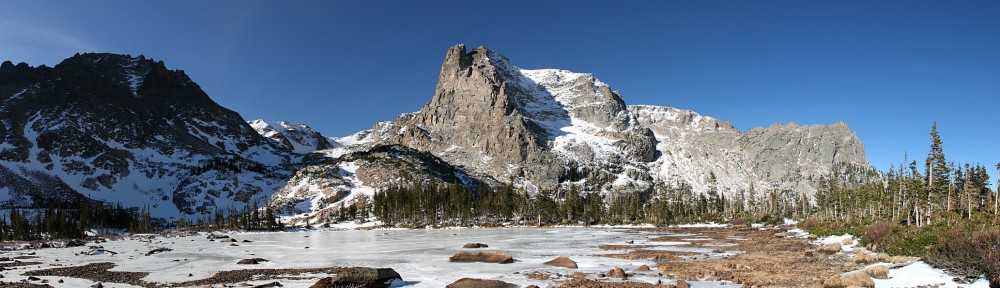
Upper Forest Lake is, I think, the most scenic of the lakes I’ve so far visited from this trailhead. This lake sits in a bowl beneath a 12,000′ high ridge of the Continental Divide. The slopes are a combination of sparse forest, grassy ramps, and rock outcroppings. There may be a trail around the lake, but if there isn’t, it looks like it is an easy lake to circumnavigate.
The summer season is nearing its end here. All the snow from last winter has melted, with the exception of the last vestiges of a couple of snow cornices. There is very little water flowing into the lake. One or two streambeds are visible due to the dark brown staining from the water that is now a trickle rather than a cascade. Only a few wildflowers survive: quite a few fireweed and the occasional queens crown, but the rest have all lost their petals or turned brown.
Sitting by the lake, I was wondering if there were any fish. The water looked… dead. No aquatic plants, very few insects buzzing above the surface of the water. Finally, I did spot a ten- or twelve-inch greenback cutthroat trout swimming about.
I’ve recently been better about carrying a telephoto zoom lens in case I encounter any wildlife. I decided that as long as I have the lens with me, I won’t spot any game. So I left the lens at home. That didn’t help – wildlife was nowhere to be seen. I continue to carry the GoPro in order to get a timelapse, but yet again the sky was cloudless, making a timelapse pointless. If these are my two biggest problems (and they were), it’s a good hike indeed.
Lower Forest Lake
Lower Forest Lake
Snapped during takeoff…
Upper Forest Lake
Butterfly
Upper Forest Lake
Butterfly
I think I’d like to return here again, early in the season. I’m willing to give another mid-June hike a shot now that I have a better idea of the terrain. Even if I lose the trail, I think I can make it to the lake. (On our June hike, we reached the lower lake quite some distance from where the trail reaches the lake.)
Continuing this summer’s exploration of alpine lakes of the Front Range of Colorado outside of Rocky Mountain National Park, I decided it was time to take a stab at the Indian Peaks Wilderness Area. Not quite at random, I selected Blue Lake, which has its trailhead in the Brainard Lake Recreation Area.
I hadn’t been to Brainard Lake before. Just about everybody I know who does any hiking at all has been there, so it’s about time I joined the club.
Wednesday, August 25
Julie joined me for this hike. She said six miles or so is her limit. The trail guide tells me that it’s a 5.1 mile round trip from the trailhead to Blue Lake and back, with only about 830′ of climb. I won’t call it an “ideal fit”, given that it’s pretty much at her limit. She tells me she’s never been to Brainard Lake, either, so a new experience for both of us.
We left my house shortly after 7am, and Google directed us up Lee Hill Drive from north Boulder. I’ve never been on this road before, so another plus. It turns out that Lee Hill Drive connects with Left Hand Canyon Drive. Not long ago, I took Left Hand Canyon Drive as a detour when Boulder Canyon was closed for construction. I didn’t realize until now, that on that day, I turned off Left Hand Canyon Drive onto James Canyon Drive, which turns into a dirt road. Left Hand Canyon Drive remains paved all the way to its junction with the Peak to Peak Highway at the metropolis of Ward.
The entrance to Brainard Lake Recreation Area is about a hundred yards north of Ward (which isn’t really visible from the Peak to Peak). It, also, is a nice paved road. So when I make a return visit to Brainard, I can drive the Lotus if I want.
We couldn’t help but notice the signs that say “Reservation Required”. This is where I admit to a failure to properly research our visit. I didn’t visit Brainard’s Forest Service website. I looked at my usual list of sites, such as ProTrails. I did find some conflicting information. One site said there was a ten-dollar entrance fee. Another said it was eleven dollars. Neither said reservations were required.
We arrived at the entrance station and greeted the ranger. “Do you have a reservation?” We did not. “Reservations are required, and they’re sold out months in advance! But I do have a few left. I can let you park in the Brainard day-use area.” We told him we were going to hike to Blue Lake. “I can’t get you into that parking area, it’s been sold out for months.” When he handed me the pass, I asked about the fee. “It’s on me today. Pay me back by having a good time!”
As it turns out, the entrance fee was neither $10 nor $11 but $14. It’s a good thing he let us in gratis, as I only had $11 on me. (Yeah, he probably could have taken a credit card.)
Brainard is using a timed-entry pass system very much like RMNP. When I got home and visited the official site, I found that some passes are still available for the dates that have been released, but just a few, and just late in the day. None would be of any use to me.
We parked in the designated lot and found the trail that leads from there to the parking lot and trailhead we really wanted to use. This adds fifteen minutes each way to the hike, so maybe another mile round trip. So now we’re pushing Julie’s limits a bit more. Oh well.
I couldn’t help but notice that, for a place that’s been sold out for months, there were very few cars. The lot where we parked was perhaps 20% full and the lot at the Mitchell Lake trailhead was about a quarter full. I guessed that, by the time we got back, we’d see full parking lots.
The trail works its way through the valley between Mount Audubon (13,229′) on the north and Little Pawnee Peak (12,466′) on the south. Mount Toll (12,979′), Paiute Peak (13,088′), and Pawnee Peak (12,943′) are at the head of the valley. Blue Lake is a fairly large lake, and the trail officially ends there. There is another, higher, lake. It’s not named on any of the maps I use, but I’ve heard it called either Little Blue Lake or Upper Blue Lake. My plan was to make it to the upper lake while Julie enjoyed the views at Blue Lake.
To get to Blue Lake, you start at the Mitchell Lake trailhead. Mitchell Lake is a bit less than a mile from the trailhead, and it’s a pretty easy hike. The trail is well-maintained, not terribly rocky, and climbs only about 200′.
Not long after passing Mitchell Lake, the trail reaches a point that overlooks the lake and the pond that’s adjacent to it on the east. This overlook is roughly where you come to the first of the ponds, this one to the north of the trail. I couldn’t help but notice that the entire slope of Mount Audubon, stretching east/west for more than a mile, is comprised of talus and/or scree. I’ve probably seen more talus than this on one hillside, but if I have, I can’t think of where I’ve seen it. I found it to be a remarkable amount of talus.
The outlet of Blue Lake is one of the feeders of Mitchell Lake, but the trail doesn’t run along the stream. I’d say that the stream is visible for most of the hike between the two lakes, but that’s not exactly true: the terrain is fairly flat here, and the stream is overgrown by willow, so you can’t really see much of it.
And, being fairly flat, there are four or five unnamed ponds along the way. This looks like ideal moose territory to me. And, overlooking the second of these ponds, we heard the snort of an animal. It was loud enough that the beast couldn’t have been very far away. Julie wondered if it might be a bear; I suggested it was probably a moose. Neither of us spotted either a bear or a moose. A few minutes later, we heard another snort. Still we couldn’t find the creature.
Nearing Blue Lake, we came across a couple of hikers asking if we’d seen the moose. Actually, this happened several times throughout the day. We’d meet hikers who asked if we’d seen the moose. One group saw two big bulls. Another saw a cow and calf. We were about the only ones who hadn’t seen moose, even though we were within earshot of their snorts. So it goes.
In due time, we reached Blue Lake, where I left Julie. The trail skirts the northern shore of the lake, climbing slightly as it goes west. The guide at ProTrails tells me, “Here the maintained trail ends, but a fairly intuitive route continues up the north shore to Upper Blue Lake.” I beg to differ. Before long, I reached a steep section of very loose footing. I nearly turned around here. I passed this bit, continuing the climb. Before long, the trail disappeared completely. Nothing intuitively obvious here.
If the trail would have been better (or more obvious), I’d have continued. If I’d have been hiking with somebody to help with route selection, I’d have continued. But alone, with no trail, I figured it would take longer than I wanted to make Julie wait for me. So I turned around.
On my way back down, I met two pairs of hikers who were thinking they’d try to reach the upper lake as well. It wasn’t my intention, but both turned around after talking to me. The first pair told me they didn’t have any off-trail experience. The second pair turned around after I pointed out the section with the loose footing. I really didn’t mean to be so discouraging.
Brainard Lake
Mitchell Lake pano
Mitchell Lake and Mount Audubon
Overlooking Mitchell Lake
Pond and Talus Slope
Moose territory!
Approach to Blue Lake
Blue Lake pano
Blue Lake
After our picnic lunch, we headed back, all the while on the lookout for moose. There was a bit more traffic on the trail than we saw on the way up, but I would not call this a crowded trail at all.
Back at the Mitchell Lake trailhead, we saw a nearly empty parking lot. And the lot we were parked in was also not more than a quarter or a third full. Here at Brainard, the timed-entry pass system is certainly keeping the crowds down.
There are a couple more trails I’d like to hike here, so I’ll definitely be back for further visits.
It was a nice, easy hike, not too crowded. And the weather was pretty much ideal – the haze we’ve experienced the last month or so from the wildfires on the west coast was not in evidence. Just another beautiful day in the neighborhood.
I’m trying to recall whether I’ve visited the Botanic Gardens before. I was there a few years ago for a concert, but I didn’t wander the grounds. I’m thinking I must have been there on a field trip back in elementary school, but I really don’t recall. So, for all intents and purposes, this is my first visit.
I certainly should have taken the real camera but figured all I’d do is take a bunch of pictures of plants I couldn’t identify if my life depended on it and that I’d never really look at again. So I left the SLR at home. And ended up taking a bunch of pictures of plants I can’t identify.
I will share them here for no more reason than because they’re pretty flowers. I don’t know anything about bees, but it looks like there are several different species buzzing around the place.
In the Tropical Conservatory, this sucker is about 20′ tall
Of the five hikes I figured it would take to reach all the named lakes in James Peak Wilderness, the hike to Heart Lake is the southernmost and the longest. It may also be the most crowded. Searching online sources for information about this hike yields a variety of conflicting information. One site says it’s 8.7 miles (round trip) to Heart Lake, another says 9.7 miles. Each gives a different number for elevation gain. I’m going with 8.8 miles and 2,061′ (net).
Saturday, August 7
This may not be the best day for a hike. In one way, it may be the worst. We’re getting the full effect of the smoke from the wildfires on the west coast. Today, according to the local news, Denver had the worst air quality of anywhere in the world. Normally, the sun is far too bright to look directly at even a few minutes after it rises. But the last few days, it was an orange disk, easily looked at. And the last few days were clear compared to today.
Gordon and Eric went with me. I picked them up at the little park and ride at the intersection of highways 72 and 93. When we passed through one of the last meadows before reaching the parking lot at the trailhead, several cars were stopped on the road. The occupants were watching a moose that was ambling eastward near the edge of the meadow. A few yards farther up the road, we spotted two deer, antlers in velvet, crossing the road. As it turns out, these three were the only large animals we spotted all day.
Arriving at the trailhead, even though we were nearly an hour earlier than I was two weeks ago, again the parking lot was nearly full. It was a bit breezy, and a bit on the chilly side. I carry a light rain jacket in my pack, but there’s not enough room for me to carry anything heavier, so I almost decided to take my hoodie off and leave it in the car. But I made a sound choice, and kept it on, figuring I’d take it off before long and end up spending the day with it tied around my waist.
Visibility was very bad. I couldn’t even tell how cloudy it was. Certainly, there were clouds. The very tops of a few peaks were shrouded, but aside from that, the sky was filled with a haze somewhere between orange and brown. I don’t think we could see anything more than about three miles away. At least it didn’t smell of smoke.
I’d say that the trail to Heart Lake is the main trail through the Wilderness. The trails to all the other lakes here are spurs off this trail. In turn, we arrive at the junctions with trails to Forest Lakes, Crater Lakes, and Clayton Lake. (Arapaho Lakes are reached via a spur trail off the Forest Lakes trail.) I chatted with a volunteer later in the day who told me that the Arapaho Lakes trail was “closed” in 2008, and the Clayton Lake trail quite some time before that. I asked him specifically about Clayton Lake. He said the route of the former trail is pretty rough and that a better way is to go to Crater Lakes and contour around a ridge to Clayton Lake. So I guess I’ll visit Crater Lakes before I make any attempt on Clayton (and the Iceberg Lakes above it).
From the junction with the Forest Lakes trail to Rogers Pass Lake, the hike is a pleasant walk through forest. It runs alongside (or, at least, never far from) South Boulder Creek and never gets very steep. There are a number of passages where we had a bit of difficulty getting through mud bogs, particularly as a backpacker told me it had rained for three hours last night.
Just before I met that backpacker, I passed a group of campers. Their tents were several yards off the trail on one side and they were grouped together on the other side. At first, I thought they had a radio on. (Okay, these days probably not a radio. But some music replay device.) But it was no radio: they were in a circle, holding songbooks and singing. Two of them had small drums. That was an interesting place for a recital. As a some-times backpacker, I couldn’t help but wonder how much the drums weighed.
Rogers Pass Lake
We arrived at James Pass Lake (on some maps, I see it called James Peak Lake) at 9:30. There were dozens of people there, some who had passed us on the trail, most who had camped there.
From James Pass Lake, the trail crosses a short ridge to reach Heart Lake. Both lakes feature grassy shores and little to no talus and only sparse willow, so they could be fairly easily circumnavigated. This also means that there is precious little shelter from the wind.
Heart Lake
I was glad I didn’t leave my hoodie in the car. Not only had I not taken it off yet, but by the time we arrived at Heart Lake, I was considering digging my light rain jacket out of the pack so I could add another layer.
The trail deposits us on the windswept south side of the lake. We agreed that it wasn’t a very pleasant place for a picnic given the current conditions, so we decided to work our way around the east shore, past the outlet, and into a small copse of krummholz. Even here, it was a bit on the blustery side. We chowed down and when finished, didn’t dilly-dally. We hit the trail for the hike out.
Crumbling infrastructure
Haystack Mtn above the far shore of Rogers Pass Lake
Queen’s Crown
James Peak almost peeking out of clouds behind Haystack Mtn
Heart Lake and Heartbeat Peak
Fireweed
Normally, Gordon is a much faster hiker than I am and no matter how much I try to keep up a good pace, he’s right behind me. By now, though, my legs were feeling a bit sore so I didn’t try very hard to keep up a good pace. Gordon, though, wasn’t close behind. I didn’t see him again until we were back at the trailhead. He showed up at the car with a phone full of mushroom pictures. On my hike to Arapaho Lakes, I took about a dozen fungus photos, thinking I’d spotted a nice variety. Gordon had at least a hundred pictures, and not too many were duplicates. Clearly, he was paying much more attention to the fungus among us than I was.
When I encounter a small number of hikers on the trail, it’s easy to keep track. On the hike to Arapaho Lakes, I met four other hikers when I was off the main trail. Today, I certainly would have lost track. I don’t think I’m exaggerating when I say I saw on the order of 300 other hikers. This is about a nine-mile hike, so it’s not quite a “conga line hike”, but it’s close.
I asked some hikers I met at the Crater Lakes junction how crowded that trail was. “It’s pretty crowded.” I’m not sure I’ll do another James Peak Wilderness hike this season, but if I do, I’ll find out just how crowded the Crater Lakes trail is.
So, on a day where the air quality had the weather service telling people to stay indoors and not to exert themselves, where the haze made for some of the worst visibility I’ve ever encountered (except when raining or snowing) and resulting in some really poor photos, hiking crowded trails, and dealing with a cold wind, you might think it wasn’t any fun. But it was a good day.
It’s time again for RMVR’s Race Against Kids Cancer.
The forecast said there was a 70% chance of rain with a high temperature in the mid-70s. They nailed it. We had the occasional sprinkles, but it didn’t rain until after I got back home.
I only gave three rides. There was a pretty good turnout for the race, but not as many people getting rides. My second passenger was a kid, about eight years old, who survived cancer.
We had a bit of an inauspicious start. They put the first passengers in our cars in the paddock and we lined up in the hot pit. We waited quite a while. After four or five minutes, the guy in front started going, and we all went out after him. The only problem was, we weren’t supposed to go yet. I don’t know why they didn’t have a marshall out there to direct us. There’s always a sign there that says if the lights are flashing, the track is closed. The lights weren’t flashing. At the start of our third lap (out lap, hot lap, in lap) we all got black flagged.
All the Ticket To Ride drivers are supposed to be experienced. We’re taking passengers out on a track with no corner workers. There’s zero tolerance for mistakes. Seems like there’s always one guy, though, that clearly shouldn’t be out there. This time he was in a Ferrari. I didn’t see the spin; by the time I got there, he was stopped in the weeds between turns 6 and 7.
For my second visit to James Peak Wilderness, I chose Arapaho Lakes.
Sometime not long ago, the trail to Arapaho Lakes was maintained. From what I understand, there used to be a sign at the trail junction, and a bridge across Arapaho Creek. Neither the sign nor the bridge exists, and I could see no evidence that a bridge was ever there. But judging by the amount and age of deadfall, I’d guess maintenance stopped six to ten years ago. Perhaps the bridge was taken out in the flood of 2013 and that contributed to the decision to stop maintaining the trail?
I arrived at the parking lot a few minutes before 8 am. This was about half an hour later than I’d planned. For the last mile or two on the road, I was followed by three other vehicles. When I arrived at the parking lot, there were only two spots left, and I’m not really sure they were spots. If I’d have been at the end of the line rather than the front, I’d have had nowhere to park. That’ll teach me to be late out the gate for hikes here.
The first two miles or so of trail is also the way to Forest Lakes. The route splits not far after the bridge over Arapaho Creek. Last time, I reported that the railing was pretty sketchy and I’m happy to say they’ve repaired it nicely. From this bridge, I kept an eye out for anything that looks like a blocked-off trail. Generally, it’s a few limbs on the ground, a visual fence. After about five minutes, I found the place.
The trail was quite clear the first few yards, but it quickly led down to a sizeable marsh. I spotted a faint trail a bit to the right, staying on higher, drier, ground. It’s not too hard to follow but requires some attention. This seems to be a detour. It clearly was never a maintained trail. I’m sure that by September, there’d be no marsh, rendering this detour unnecessary.
Back on the trail that used to be maintained, the walking is easy except for an occasional tree trunk across the trail. Less than half a mile off the Forest Lakes trail, we arrive (again) at Arapaho Creek. I spotted a trail on the opposite bank. (I now think this is the site of the former bridge.) I didn’t want to cross here, so I kept going on the trail. According to the CalTopo map, if you stayed on this side of the creek the trail would take you to the outlet of lower Forest Lake. But this trail dumped me into another marsh.
I plowed through to the next clump of trees upstream. By this time, I was above the confluence of Arapaho Creek and the outlet of Forest Lakes. I searched for a crossing here. It didn’t take long, but once I was across, I knew I’d have a short bushwhack. There was another small stream between the two outlet streams, so I ended up with three crossings total rather than the one where I’m guessing the bridge formerly stood.
A few yards after my third crossing, Arapaho Creek, I was back on the trail. I regained the trail at the base of a fairly steep climb: 500 feet up in 1500 feet to the west. None of this was treacherous. The footing was generally good; there were lots of roots that made for nice steps. In places, it’s a lot like climbing stairs. The good thing is, you’re climbing pretty much adjacent to the creek. You don’t always see the creek, but when you do, it’s a falls or a cascade. I enjoyed several short pauses to take in a few breaths and the spectacle of the falling water.
As soon as we’re out of the forest, the trail nearly levels off. The expansive view appears as if a curtain had opened. We’re above 10,800′ elevation here. I was taking my time when a hiker and his dog passed me. He was the first hiker I saw in quite a while. I was a bit surprised to see somebody; I was beginning to think I had the place to myself (other than the mosquitoes).
I did see a few fresh-looking boot prints. I’m guessing it rained yesterday afternoon or last night. The prints didn’t look to me like they’d been rained on. I saw at least one print heading in each direction, so I’m guessing somebody has already made the round-trip this morning.
The lakes lie at about 11,150′ above sea level. The smaller, western one is four feet higher than the larger, eastern one. The southern bank is grassy, and the grass is heavily sprinkled with wildflowers. The north shore is a mix of rocks and willow and krummholz. The trail skirts the south side, petering out before reaching the western end of the lake. Any route generally to the west from here will get you to the eastern shore of the upper lake.
Near the outlet of the lower lake
The sky was a bit hazy due to some combination of humidity and the smoke from West Coast fires. It wasn’t just hazy, it was also mostly cloudy. Here at the lake, it was windy. There’s nothing resembling shelter here. And because it’s not a nice, bright, sunny day, it’s a bit on the chilly side. Unusually, the wind was from the east. There were a couple of layers of clouds. The lower clouds were pushed on that easterly wind towards the divide. They moved so fast it was as if you’re watching a time-lapse. A few small clouds were higher. They moved slowly in nearly the opposite direction.
I sat there, eating my picnic, watching the clouds fly by, listening to the squirrels and marmots chirping and barking, for forty-five minutes. When I stood up to leave, I saw another hiker a couple of hundred yards away, hiking away from me. She couldn’t have been here long; she didn’t come to the second lake.
On the way down, I stopped at one of the many scenic spots and took a few photos. The man and his dog passed me again. This time we chatted. He’s getting married in Estes Park in a few weeks, then he and his bride will hike to the summit of Longs Peak. We chatted about hiking in RoMo and about the fire damage and trail closures. This was his first hike in James Peak. We agreed that this area is a nice Plan B when you can’t hike in the Park.
Dew drop in…
Elephant’s Heads
Island in the stream
The lower lake
The upper lake
King’s Crown
Pollination action
As to crossing the river on the way down, I had a bit of an internal argument. My intention was to follow the trail to its end where the former bridge was to verify whether there’s an easier crossing. “What if I can’t find a good place to cross?” That’s a stupid question: I’ve proved I can find a crossing. “What if I can’t find the same crossing point?” What’s with the stupid questions? I found that crossing, I can find another.
I went to the end of the trail. I was back at the place I didn’t cross on the way up. I spent some time judging whether I could cross. Any potential crossing involved a step or two in water deeper than my boot tops. I could take my boots off and wade, but without trek poles, I was concerned about slipping. I decided to backtrack and cross the way I did in the morning. I quickly found two of my three crossing points but for the third, I chose a place that was slightly inferior to my route in the morning.
Just before regaining the Forest Lakes trail, I ran into two more hikers. I mentioned the stream crossing. One responded, “I’m not worried, I’m wearing boots.” These were the third and fourth people I encountered in four hours, but these guys hardly count, as I was nearly back to the crowded trail anyway. Not total solitude, but damn near. Not bad for a Sunday.
Back on the Forest Lakes trail, from the bridge with the repaired handrail back to the parking lot it was pretty busy. Not “conga line hike” busy, but I never went more than a few minutes without encountering other hikers. Individuals (with dogs), pairs (with or without dogs), large groups (all with dogs).
Dogs aren’t allowed on the trails in RMNP, so I’m not accustomed to seeing them. I’m surprised by the number of dogs. All along the trail are little plastic bags of, presumably, dog poo. I’m hoping that they were left beside the trail by hikers and their dogs going up the trail and they’ll be collected by those same hikers on their way out.
On today’s episode of “What did I forget?” we have a map and mosquito spray. Last night, getting into bed, I thought “I need to print a map in the morning. And I should take the bug spray with me” Nope, didn’t happen. I wasn’t concerned about being mapless, though; I’ve been studying the map for some time. But I sorely missed the mosquito repellent.
Also on the list: sunscreen. I didn’t forget to take it, but I didn’t remember to apply it until I was nearly back to the main trail. “Better late than never” doesn’t always include sunscreen. Luckily, I emerged unburnt.
I really enjoyed the hike. It’s not too long, at 7.1 miles round trip. It does have a very strenuous section in the middle, a stream crossing (or three), and some route-finding skills come in handy. I didn’t quite have the place to myself, but that might be a different story on a weekday.
In addition to the open views above treeline, and the extended climb alongside the falling water, there was an abundance of wildflowers. Blues and yellows in the lower elevations, reds and oranges and violets up higher. I saw only a few columbines, all fairly low. One of my new favorites, Elephant’s Heads, is quite common here. There is also a profusion of mushrooms.
I met Kevin on our club drive over Trail Ridge Road. We were parked together at the Alpine Visitors Center and again at our next stop. He has an Elise, but that day he was driving his freshly purchased orange 2015 McLaren 650S Spider. As you might guess, his car was the center of attention everywhere we went.
It’s natural to assume that anybody driving a McLaren is going to field a bunch of questions about the car. And it’s not much of a stretch to think that a guy wearing a race track hat and with numbers on his car might find himself in a conversation about track days. So, naturally, the topic of Kevin taking the McLaren to the track came up. And, of course, I had to ask if I could drive it.
Before long, it was all arranged.
Thursday, July 22
I like these Thursday evening sessions. The heat of the day is over, and there aren’t as many cars as usual. Generally, the first hour is broken into fast and slow groups, with the rest of the evening open for everybody. You can run in the dark if you’re hardcore, and there’s always the chance of showers.
Kevin and his wife, Erin, were gassing up when I arrived. We picked our spot in the paddock, trying to have enough room for four cars. It was Kevin and Erin, myself, Scott (Elise), and his friend (BMW M2). We got checked in, then attended the drivers meeting.
I reminded Kevin that I’m not an instructor, but that I’m happy to give him some tips. We agreed that the best sequence would be for him to ride with me in the Elise, then I ride with him, then I drive his car.
With Kevin as passenger, we did an out lap, then four full laps, then an in lap. This is Kevin’s first time on a track, so when he got behind the wheel, he’d only really only been on track for four laps. And he’s only had the car for a short while, and there’s no place on the streets to really drive the car. So he was facing a daunting task. Add to that, my lack of awareness: I didn’t think to make sure he had all the drivers aids enabled.
Let’s just say his first few laps were difficult.
I’ve never had any instruction on the track. And when I visit new tracks, I like to figure them out on my own. At Portland International, I had an instructor for a session, more of a navigator, really, and again for a few laps at COTA. There wasn’t a lot of communication – with the engine right behind my head, with a helmet on, and a case of tinnitus, I can’t hear anything the passenger might be saying. So it’s down to hand signals. With only 15 or 20 laps of this sort of thing, I really don’t know what I’m doing.
I was not giving him any help at all for his first couple of laps. I wasn’t really sure what to do. But after a while I got comfortable. The first signal I needed was to brake: I held my hand out, palm down, and pushed down. I don’t know if that’s generally the signal, but he understood immediately. I quickly had four or five signals and none were misunderstood. All right! I’m helping!
The big thing, though, for his first session behind the wheel was that he had disabled some of the aids. That unnecessarily added to his difficulties. He was facing a steep enough learning curve as it was. He turned them all back on at the end of that first session.
I faced a bit of a learning curve myself. As a passenger, I got a sense of the power of the car, and felt the braking. But it’s not the same as driving. We had it in automatic mode, so all I needed to do was brake and steer, but that was plenty. Starting it wasn’t a problem, but Kevin had to put it in drive for me, as I couldn’t figure it out on my own.
I think, given my experience, if I had a couple of full days with this car, I could drive it fast with some of the aids turned off. I think.
I didn’t go where it says I went…
“Face cam” view. 137mph
High Clutch Temperature
It’s quite a machine. At 650hp, it’s the most powerful car I’ve driven. It’s almost three and a half times the horsepower of the Elise. On the other hand, it weighs over fifty percent more than the Elise. Still, it has a much higher power-to-weight ratio than the Elise. It’s on bigger, softer tires, it has bigger brakes, and active aero. We drove it with the top down.
You put your right foot down and the car just launches out of the corners. We hit 137 on the highway straight. That’s 25mph faster than I’ve done in the Elise. I managed to go at least 10mph faster on all of the straight bits of track.
I felt challenged by the braking and cornering. The Elise is very light. Even the two cheap race cars I drove were pretty light. The McLaren felt very heavy to me. I’m not sure how often the computers stopped me from doing bad things, but I don’t think it was often. A few times, I felt a bit of delay on the throttle exiting turns, but I didn’t really feel the sorts of things I felt when I was a passenger in the Ferrari 458. Nothing obtrusive.
In the Elise, I use a CG lock on the seatbelt. Without it, I’d move around quite a bit more. The McLaren just has regular seat belts. I felt secure in the seat and didn’t move around at all.
Visibility was pretty good. Or, at least, not any worse than the Elise. Except in one case: under heavy braking. The rear wing pops up as an air brake. It fills the rear-view mirror. I never did get used to it. I kind of like knowing where any following cars are when I’m hard on the brakes.
Somewhere around here, I’d give you my lap time. But I don’t have a lap time.
And I don’t have a video.
I ran the lap timer with the phone in my pocket. I’ve done that a number of times before and not had any issues. But today the GPS track it recorded is not anywhere near where I drove. It was fine in my car, mounted to the dash, but miserable in my pocket.
As to the video, I took a suction cup mount that I had in a drawer. I exercised it the night before, but when I went to put it on his car, it broke. I had a backup plan, though. I had also found a curved adhesive mount and stuck it on my helmet. I didn’t want to put it on the vinyl, so I put it below my visor. It was out of my sight, which was good. But it was facing too low. All I got was ten minutes of the steering wheel, dashboard, and my arms and lap. Not exactly compelling viewing.
I will recount two notable incidents.
When I exited the track the first time in his car, the track manager, Glen, motioned me to stop. “You crossed the commit line.” This is a major foul. There’s a white line separating the track from the pit exit. You’re not to cross this line. I was certain I didn’t cross it. “Yes, you did. I just got a call from the corner worker.”
After we parked, I went to talk to Glen. “I don’t want to argue, but I’m pretty sure I didn’t cross the line.” He repeated that the corner worker reported me; it was not Kevin. “I can show it to you on the video.” Please do. He rewound the footage, found the McLaren, ran it a couple of times over. “You are correct. You did not cross the line.” Vindicated!
My second time in the McLaren, I finally put together a nice lap. I don’t know how nice a lap it was, sadly, but it felt good. The previous lap I missed my braking point going in to turn 4, the fastest place on the track, and ran quite wide. For a while I was thinking I wouldn’t keep it on the track, but in the end I had six inches to spare. But that’s not the second notable incident.
The lap after my nice lap, the car felt quite sluggish under acceleration. On the long straight, we only got up to 100. Then I saw the warning: “High Clutch Temperature”. A few turns later, we were definitely in limp mode, unable to top 35.
“Sorry I broke your car!”
By the time we parked, the warning was off and all was well again. I believe Kevin did get the same thing later in the evening. It doesn’t seem right to me that it would overheat like that so quickly, but perhaps it’s partly to do with the mode we were operating the car in. I really don’t know anything about it. There are two selectors with three or four positions in each. Perhaps we were using a combination that wasn’t expected on the track.
In addition to me giving him a ride in the Elise and attempting to give him hand signals when he was driving, we tried to do two lead/follow sessions. The idea was, he’d try to follow my line through the turns but not pass me on the straights. I had it in my mind that I’d go slow. But I didn’t go slow enough. I’ve seen enough first timers on track to know they’re going to be slower than me. Maybe much slower. I didn’t account enough for that.
As well, we had to deal with traffic. A couple of times, cars that Kevin would wave by wouldn’t pass me. So we got separated a few times. And for one of these sessions, I was giving Erin a ride. After I got a certain distance ahead of Kevin, I put my foot down and turned my fastest lap of the day. Gotta show off for the passenger, right?
Normally up at the start of these reports, I give an inventory of the cars in attendance. I didn’t wander around and talk to any of the other drivers. This time, it was all about the McLaren.
I seem to randomly get invited to these things. Didn’t get invited last year when I spent money in their shop, did get invited this year but haven’t spent a nickel there in eighteen months. So it was very nice of them to include me. I’m a big fan of free track days, and even though I can’t tell any of the Ferraris apart, it’s pretty cool to see so many of them in the paddock.
I was told the car count was forty or forty-two. Eight were Lotus, unless I miscounted. I saw an Audi in the paddock but don’t know if he went on the track. There were four or five Porsches, two of which I saw on the track. And I think all the rest were Ferraris. And there were some Ferraris there that didn’t go on the track for a total of maybe three dozen.
I get a real ego stroke from these Ferrari track days. Totally undeserved, but prideful nonetheless.
Somehow, the car still gets admiring looks, even in this crowd, even with all the wear and tear of nearly 90,000 miles and 50ish track days. I’m starting to call her a “thirty footer”: looks best from thirty feet away. Most people tell me it’s great that I drive it so much. In this crowd, I felt I had to point out that my car had nothing theirs had: not a stitch of leather, no cup holders, no radio, no air conditioning, no cruise control, no traction control, no horsepower. And on hard tires.
At the drivers meeting there was a show of hands: about half the drivers hadn’t driven on a track before. That’s pretty normal for this crowd. We’d have novice and experienced groups for the first hour, but all afternoon would be open track. So I’d be out there with the guys that don’t know how slow they are. I try to keep in mind how slow I was my first time, and that there’s a bit of sensory overload, but it does annoy me when they don’t pay attention to their mirrors.
I am reminded of that scene in The Gumball Rally when Raúl Juliá says, “The first rule of Italian driving is, what’s behind me is not important.” Whereupon he throws his rear-view mirror out of the car.
Let’s break the Ferrari guys into groups. The first group are the few who are in over their heads. Totally clueless. They’re the ones not looking in the mirror. I wonder how they managed the lead/follow session. They should start by taking a ride with an instructor. They do a few laps but leave as slow as they arrived. They’re big fans of hauling ass down the straights but take the turns twenty or thirty miles an hour slower than I do. I’m guessing they’re one and done so far as track days go.
The second group are slow, but they’re trying. They’re paying attention. Today there were more of these than the first group. Two of them caught my attention. I was somewhat faster than they were. They’d easily pull me on the straights, but I made up more time than that in the corners. Each one pointed me by and slowed to get behind me. Each was able to keep up, and after a couple of laps behind me, they were better in the turns. That gave me a warm fuzzy.
In one session, I reeled in three of them, one after the other. I’d have them in my sights for a lap and a half or so, and when I’d get close enough I might pass them in another lap, they pulled into the pits. My enormous ego wants to believe they saw me coming and didn’t want to get passed by an Elise.
The third group had spent some time at the track. One chap I talked to used to have a Lemons team. One yellow Porsche sported numbers on his doors, one Ferrari was trailered in. I think every Ferrari and Porsche there was capable of a sub-two-minute lap. I don’t know that anybody did one, but there were a few that were close.
I gave rides to all who asked, which amounted to two of my Lotus brethren. Nobody got sick, and they seemed to enjoy it, so that’s good.
As the day wore on, more and more people told me they were impressed with my speed. An ego stroke, for sure. But given the experience difference, I think it’s a bit like playing basketball with a bunch of sixth graders. I’d be a dominant player, no matter how expensive the kids’ shoes are.
When not on the track, I struck up a few conversations. Any Ferrari driver I talked to for more than a few minutes, I asked if I could take their cars out for a few laps. Nobody laughed, and nobody told me to fuck off. But I didn’t get any takers. I figure it doesn’t hurt to ask. Heck, I’ve been asking to drive strangers’ formula cars for years now. (Not that I’ve had success there, either. One guy said he’d be happy to let me drive his formula car, but he died before we got it arranged.)
Somehow, my lap timer app failed to record any of the OBDII data. Somehow, the phone wasn’t paired with the dongle. I paired them, and the settings look correct, but I didn’t get any data. Also, on my third run, I failed to get the forward facing camera started. If that’s the worst operator error of the day, it’s a good day.
I had a great time hanging with the one-percenters. I had a blast on the track. My gracious hosts fed me lunch and kept me hydrated. I spent some time with people who share one of my passions. We couldn’t have asked for better weather. What’s not to like?
I think this is the sixth time I’ve visited Andrews Tarn, most of those back in the 1980s. The first two visits, we hiked a loop: up Flattop Mtn, along the divide, and down the glacier. Back then, the foot of the glacier was in the tarn, rising perhaps eight or ten feet above the water. My previous visit was back in 2007 and I was disappointed to see how far the glacier retreated. Today, there’s still snow on the ground between the glacier and the tarn, so I couldn’t tell how much smaller the glacier is now than it was forty years ago.
This is my first experience with the timed entry passes for the Bear Lake corridor. A permit is now required if you want to go to any destination on Bear Lake Road. The passes begin at 5 am and the last time slot available is 4 pm. For my purposes, only the 5 am and 7 am time slots will work. When I arrived at the entrance station, a few minutes before 8, they had all but one lake closed with traffic cones. And there was nobody in the booth. A few yards up Bear Lake Road they check your permit and give you a permit. They said, “Put this on your dashboard” but it has a post-it note sort of adhesive and it looked like most folks stuck it on their windshields as I did.
Unless I’m in the park well before 7, I don’t bother trying to park in either the Glacier Gorge or Bear Lake parking lots. I pulled into the park and ride to see quite a long line waiting for the shuttle bus. Face masks are required on the shuttle. If you don’t have one, they’ll give you one. The driver’s area is closed off to the rest of the bus, so everybody boards and exits through the back door. (Not really a back door, but you know what I mean.)
The Foster guide says 4.6 miles and a vertical climb of 2,200′ to the tarn.
Follow the crowd to the Loch and keep going up the trail to Sky Pond. At about three-quarters of a mile after reaching the Loch the trail crosses Andrews Creek. If I didn’t know there was a trail here, I wouldn’t have seen it. There’s a sign on the south side of the trail, but it was in dark shade. And the first few yards of the trail to Andrews is solid rock.
At this point we’re about three-quarters of the way there but we’ve only climbed a bit more than half the total: the last mile climbs a thousand feet.
The trail climbs on the west side of Andrews Creek. The trail bends slightly to head due north. Fairly quickly you arrive at the Andrews Creek campsite. It’s off to the right; the trail continues to the left, now going pretty much due west. Not long after that, you leave the forest to find in front of you a canyon full of talus. On the right, the north, is the eastern arm of Otis Peak, towering twelve or thirteen hundred feet above the trail.
The trail now alternates between a crude trail and sections of rock-hopping across the talus. It seemed like there was a small cairn every few yards, which seemed excessive. By now we’re well over ten thousand feet, and the one-in-five climb is starting to take its toll. I figured I have all day – it’s not a long hike, and I got a fairly early start. I took several breaks.
At one breather, I chatted with a hiker who caught up to me. He had a slight accent. I asked where he was from. “It’s complicated. I’m from France, but I’ve been in Denver since the pandemic. But I live in New York, and I hope to be back there soon.” He didn’t spend much time at the lake – he passed me on his way down before I even made it up there.
The last seven or eight hundred feet before the top climbs almost straight up, between a large snowfield and a clump of trees clinging to the top of a rock outcropping. The footing is less than ideal in places.
When I topped the crest, I knew why the French guy didn’t stay long: it was quite windy. Andrews Tarn is pretty stark. A little halo of tundra arcing around the outlet, talus everywhere else except the western shore, which is snow. Here, years ago, I watched a skier come to a stop at the brink, just a few feet short of a ten-foot drop into the drink. Today it’s just snow. The glacier has retreated quite far up the hillside.
Andrews Tarn beneath Otis Peak
I emulated my French friend and left after just a few minutes. The wind was relentless and there is no shelter here. I headed back down to just a bit above where the trail crosses the creek for the last time, just below the snowfield. There’s a large boulder here, perhaps twenty feet across. Part of the creek is running underneath it, undermining it. I wonder how often it moves. Does it shift a couple of inches every now and then?
Andrews Glacier
Sharkstooth
I heard the barking of marmots at the lake but didn’t hear them here. I was fairly close to the water, so I’d only hear things in my immediate vicinity. I saw a pika. I spotted him three times, each time a few yards farther away. He never came back. Although I was bothered by mosquitoes in the forest, there were none here. Very few insects at all.
After my pleasant picnic I headed back. It seemed that, at every patch of talus, I’d manage to lose the trail. I didn’t see nearly as many carins on the way down as I recalled on the way up. Maybe there should have been more! I find it’s generally pretty easy to spot the trail when you’re above it, and it was never really out of my sight. It’s just that there often seemed no obvious way through the talus. I didn’t have any difficulty on the way up.
Back in the forest, the creek (or part of the creek, actually) enters a small pool. It’s fairly deep, but the water is moving quite quickly at the surface. It’ll never be mirror-smooth. Perhaps it’s my imagination, but the water looks to have just the slightest tint of that turquoise you often see in glacial melt. I refilled my water bottle near here. Fantastic!
I took a final break just a few yards above the junction with the trail to Sky Pond. In the four hours since I was here in the morning, I encountered ten or twelve other hikers. My break here was only about fifteen minutes and I saw about twice that many people on the Sky Pond trail. It just reinforces how much I like getting on the less well-traveled trails.
I made it back to the shuttle bus at about 3 pm.
This hike kicked my ass. I can’t recall the last time I thought a sub ten mile hike was difficult. I know this trail kicked my ass the last time I was here. That was 2007, when I was twenty or twenty-five pounds heavier and living in Phoenix, not acclimated to altitude. I have no excuses this time. I’m typing this up two days later and my legs are still sore.
Seems like I’ve missed the last few club drives for one reason (excuse?) or another. I enjoy going on the club drives for a few reasons. One of the main reasons is that we’re often driving routes that include some time on roads I’m not familiar with.
This time, though, we took a route that is quite familiar to me. My typical modus operandi when I hike on the west side of RMNP is to take I-70 west to US 40, cross Berthoud Pass, cruise through Winter Park, Fraser, and Granby, and from there catching US 34 through Grand Lake and into the park. After my hike, I typically take Trail Ridge Road into Estes Park, then head home on US 36. Today’s route was exactly this, but in reverse. Nothing new here for me to see.
But it’s always a pleasure to meet up with a group of folks with whom I share a passion. And, besides, my annual park pass has expired and I need to get a new one. And, finally, this would be my first chance to get a glimpse of the damage done by the East Troublesome wildfire that blew through the Park late last summer.
We met at the Safeway gas station in Estes Park early enough that we didn’t need any timed entry passes for the day. Which meant we needed to be through the entrance station by 9am. I’m typically in the Park and on the trail by 7 or 7:30, so I didn’t really have any idea how many people are trying to get in at about 8:30. It turns out it was a good thing we left our assembly point a few minutes earlier than planned: the line was already quite long, about half way from the entrance station to the Beaver Meadows visitor center.
It was a long wait. I didn’t time it, but I’m sure it was 20 or 30 minutes. This proved to be an uncomfortable wait for some visitors. A few cars in front of me was a family in an SUV. At one point, the father got out of the car and helped his son. The son, about 4 years old and still in his pajamas, really, really, really needed to pee. Dad got him a few feet off the road where he dropped trou and let fly. Like a firehose. I’ve never seen anybody pee such a great distance. I’m sure he was quite relieved!
Once we were into the Park and moving again, I don’t think we topped 25mph on our way to the Alpine Visitor Center. I’m not sure the timed entry passes are keeping visitors out of the Park. Everybody knows when access is restricted, so they (like us) just planned to get there before a pass was necessary. All the parking areas along Trail Ridge Road were pretty full. I was concerned that we wouldn’t be able to park our more-than-a-dozen cars. My concern was unfounded: there was still plenty of parking available.
Our planned photo stop was at a small dirt parking lot at Beaver Ponds picnic area. It’s just big enough to get all our cars into, assuming there’s nobody else already there. We were in luck: there were only a couple of cars there. The kids who were there were much more interested in looking at our cars (and asking lots of questions) than they were in the beautiful natural scenery.
From this stop to the entrance station, I was quite curious to see the fire damage. The main problem I had was that I was driving. As such, I’m pretty much required to keep my eyes on the road. So I just held the camera one-handed out the window or over my head, pointed it more or less in the direction of whatever I wanted to see, and snapped away. I shot a couple of dozen pictures this way. The combination of my inability to compose a shot and moving at something like 50mph makes for less than stellar pictures. But some were interesting nonetheless.
One of the things that struck me was the number of trees that were broken eight or ten or twelve feet above the ground and all facing in the same direction. I’ve hiked many times through burn scars and have never seen anything like it before. Typically, these dead tree trunks just topple over, lifting a disk of roots with them. I’ve only seen tree trunks snapped off above the ground by avalanches. In those cases, I’m thinking the trunks are snapped off six feet above the ground because there was six feet of snow on the ground when the avalanche struck.
Here, I can only think the wind must have been the agent. Why else would all the downed trunks face the same direction? And it wasn’t just in one spot – I saw this several times along those few miles of road. True, the trunks aren’t always snapped off. Quite often the trees are just bent over with the tops touching the ground. I find it very interesting.
Our next stop was lunch in Winter Park, at the Winter Park Pub. They had cordoned off most of their parking lot for us and we basically occupied all their outdoor seating. I couldn’t help but be amused that they pretty much were out of everything I wanted to order. I’d have loved to have had iced tea, the turkey avocado bacon sandwich, and onion rings. Before ordering, I changed my mind and decided on fries instead of rings. In the end, I had diet Pepsi (“Sorry, we don’t have any iced tea.”), and substituted chicken for turkey on the sandwich (“We’re out of turkey”). Kevin ordered onion rings, but they were out of those, too. I can’t help but wonder what they’d be out of by dinner time.
There were quite a few people on this drive who I hadn’t met before. I generally try to introduce myself to anybody I haven’t met before but somehow managed to sit at a table with folks I’ve known for quite some time. I’ll have to try harder next time to mingle. These drives aren’t just about the cars and the roads: it’s the people who make it all worthwhile.
Lunch was the end of the organized portion of the drive. From Winter Park, we were all on our own to get home. The only real effect this had was that, rather than keeping together in a tight group, we got spread out over the countryside. Most of us were still more or less together over Berthoud Pass, and I wasn’t on my own until I was just a few miles from home.