Continuing this summer’s exploration of alpine lakes of the Front Range of Colorado outside of Rocky Mountain National Park, I decided it was time to take a stab at the Indian Peaks Wilderness Area. Not quite at random, I selected Blue Lake, which has its trailhead in the Brainard Lake Recreation Area.
I hadn’t been to Brainard Lake before. Just about everybody I know who does any hiking at all has been there, so it’s about time I joined the club.
Wednesday, August 25
Julie joined me for this hike. She said six miles or so is her limit. The trail guide tells me that it’s a 5.1 mile round trip from the trailhead to Blue Lake and back, with only about 830′ of climb. I won’t call it an “ideal fit”, given that it’s pretty much at her limit. She tells me she’s never been to Brainard Lake, either, so a new experience for both of us.
We left my house shortly after 7am, and Google directed us up Lee Hill Drive from north Boulder. I’ve never been on this road before, so another plus. It turns out that Lee Hill Drive connects with Left Hand Canyon Drive. Not long ago, I took Left Hand Canyon Drive as a detour when Boulder Canyon was closed for construction. I didn’t realize until now, that on that day, I turned off Left Hand Canyon Drive onto James Canyon Drive, which turns into a dirt road. Left Hand Canyon Drive remains paved all the way to its junction with the Peak to Peak Highway at the metropolis of Ward.
The entrance to Brainard Lake Recreation Area is about a hundred yards north of Ward (which isn’t really visible from the Peak to Peak). It, also, is a nice paved road. So when I make a return visit to Brainard, I can drive the Lotus if I want.
We couldn’t help but notice the signs that say “Reservation Required”. This is where I admit to a failure to properly research our visit. I didn’t visit Brainard’s Forest Service website. I looked at my usual list of sites, such as ProTrails. I did find some conflicting information. One site said there was a ten-dollar entrance fee. Another said it was eleven dollars. Neither said reservations were required.
We arrived at the entrance station and greeted the ranger. “Do you have a reservation?” We did not. “Reservations are required, and they’re sold out months in advance! But I do have a few left. I can let you park in the Brainard day-use area.” We told him we were going to hike to Blue Lake. “I can’t get you into that parking area, it’s been sold out for months.” When he handed me the pass, I asked about the fee. “It’s on me today. Pay me back by having a good time!”
As it turns out, the entrance fee was neither $10 nor $11 but $14. It’s a good thing he let us in gratis, as I only had $11 on me. (Yeah, he probably could have taken a credit card.)
Brainard is using a timed-entry pass system very much like RMNP. When I got home and visited the official site, I found that some passes are still available for the dates that have been released, but just a few, and just late in the day. None would be of any use to me.
We parked in the designated lot and found the trail that leads from there to the parking lot and trailhead we really wanted to use. This adds fifteen minutes each way to the hike, so maybe another mile round trip. So now we’re pushing Julie’s limits a bit more. Oh well.
I couldn’t help but notice that, for a place that’s been sold out for months, there were very few cars. The lot where we parked was perhaps 20% full and the lot at the Mitchell Lake trailhead was about a quarter full. I guessed that, by the time we got back, we’d see full parking lots.
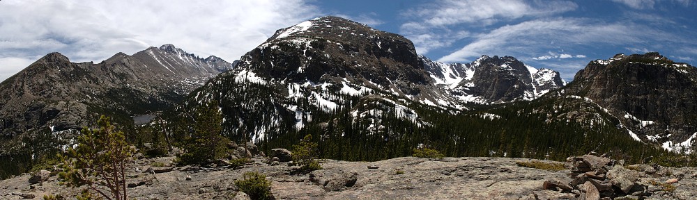
The trail works its way through the valley between Mount Audubon (13,229′) on the north and Little Pawnee Peak (12,466′) on the south. Mount Toll (12,979′), Paiute Peak (13,088′), and Pawnee Peak (12,943′) are at the head of the valley. Blue Lake is a fairly large lake, and the trail officially ends there. There is another, higher, lake. It’s not named on any of the maps I use, but I’ve heard it called either Little Blue Lake or Upper Blue Lake. My plan was to make it to the upper lake while Julie enjoyed the views at Blue Lake.
To get to Blue Lake, you start at the Mitchell Lake trailhead. Mitchell Lake is a bit less than a mile from the trailhead, and it’s a pretty easy hike. The trail is well-maintained, not terribly rocky, and climbs only about 200′.
Not long after passing Mitchell Lake, the trail reaches a point that overlooks the lake and the pond that’s adjacent to it on the east. This overlook is roughly where you come to the first of the ponds, this one to the north of the trail. I couldn’t help but notice that the entire slope of Mount Audubon, stretching east/west for more than a mile, is comprised of talus and/or scree. I’ve probably seen more talus than this on one hillside, but if I have, I can’t think of where I’ve seen it. I found it to be a remarkable amount of talus.
The outlet of Blue Lake is one of the feeders of Mitchell Lake, but the trail doesn’t run along the stream. I’d say that the stream is visible for most of the hike between the two lakes, but that’s not exactly true: the terrain is fairly flat here, and the stream is overgrown by willow, so you can’t really see much of it.
And, being fairly flat, there are four or five unnamed ponds along the way. This looks like ideal moose territory to me. And, overlooking the second of these ponds, we heard the snort of an animal. It was loud enough that the beast couldn’t have been very far away. Julie wondered if it might be a bear; I suggested it was probably a moose. Neither of us spotted either a bear or a moose. A few minutes later, we heard another snort. Still we couldn’t find the creature.
Nearing Blue Lake, we came across a couple of hikers asking if we’d seen the moose. Actually, this happened several times throughout the day. We’d meet hikers who asked if we’d seen the moose. One group saw two big bulls. Another saw a cow and calf. We were about the only ones who hadn’t seen moose, even though we were within earshot of their snorts. So it goes.
In due time, we reached Blue Lake, where I left Julie. The trail skirts the northern shore of the lake, climbing slightly as it goes west. The guide at ProTrails tells me, “Here the maintained trail ends, but a fairly intuitive route continues up the north shore to Upper Blue Lake.” I beg to differ. Before long, I reached a steep section of very loose footing. I nearly turned around here. I passed this bit, continuing the climb. Before long, the trail disappeared completely. Nothing intuitively obvious here.
If the trail would have been better (or more obvious), I’d have continued. If I’d have been hiking with somebody to help with route selection, I’d have continued. But alone, with no trail, I figured it would take longer than I wanted to make Julie wait for me. So I turned around.
On my way back down, I met two pairs of hikers who were thinking they’d try to reach the upper lake as well. It wasn’t my intention, but both turned around after talking to me. The first pair told me they didn’t have any off-trail experience. The second pair turned around after I pointed out the section with the loose footing. I really didn’t mean to be so discouraging.


After our picnic lunch, we headed back, all the while on the lookout for moose. There was a bit more traffic on the trail than we saw on the way up, but I would not call this a crowded trail at all.
Back at the Mitchell Lake trailhead, we saw a nearly empty parking lot. And the lot we were parked in was also not more than a quarter or a third full. Here at Brainard, the timed-entry pass system is certainly keeping the crowds down.
There are a couple more trails I’d like to hike here, so I’ll definitely be back for further visits.
It was a nice, easy hike, not too crowded. And the weather was pretty much ideal – the haze we’ve experienced the last month or so from the wildfires on the west coast was not in evidence. Just another beautiful day in the neighborhood.