Sunday May 20
Today’s drive was from Montrose to Durango with an extended visit to Mesa Verde. The route was over Lizard Head pass and through Dolores and Cortez. As with most of the rest of this trip, it was a route we’ve taken before. It’s a beautiful route. Our only concern was the timing of potty stops. John has people in Ridgway and told us that there are bathrooms at the park there, so as we passed through town we dropped out of line and into the park. Sadly, John’s info was bad and there were no bathrooms to be found. So we were tail-end Charlie again.
We caught the group before long at a wide spot on the road just before Telluride. We weren’t going to Telluride, but making a right turn near there. This wide spot was an opportunity for a group photo. John’s next piece of info was that there were no bathrooms at the summit of Lizard Head pass, so we figured we needed to stop before then.

Obligatory group photo
At the right turn there’s a gas station, so we again dropped out of the queue. Just as we approached the summit of Lizard Head we caught up to a motor home. I was looking for a way around it when I caught a glimpse of orange in the parking lot. We weren’t expecting a stop here. It was the original target for the group photo, but as that was already taken care of we thought we’d be skipping it. Turns out John’s second piece of intel was incorrect, too. There are, in fact, bathrooms at the summit of Lizard Head pass. It was our error to doubt Mike.
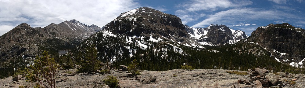
The drive from Montrose to here at the summit of Lizard Head Pass is gorgeous. Mile after mile of fantastic views – snow-capped peaks and aspen groves – connected by roads that curve and swoop, rise and fall. There are many scenic drives in Colorado but this one certainly goes near the top of the list.

The Galloping Goose
Our next pit stop was in Dolores. Our chosen gas station here was next door to the an old train station that now houses the Galloping Goose Historical Society. In the 1930’s the Rio Grande Southern Railroad was facing financial difficulties. They came up with an interesting solution: the Galloping Goose. It’s a railcar operated by motor rather than steam, much lighter (and therefore reduced impact on the railroad), and has a front-end that looks like a bus. Seven of these were produced, and the one here in Dolores operates as a tourist attraction.
From Dolores we headed to Mesa Verde National Park. We weren’t sure if the restaurant in Mesa Verde was open yet, being early in the season. So we made a detour in Cortez to stop at the Subway for sandwiches. We left Dolores before the rest of the pack but still ended up at the visitor center after everyone else.
Genae, having lived a while in Durango, has visited Mesa Verde many times. I have been here a few times, last being in 2013 when I hiked to Petroglyph Point. I never really explored much of the park, having each time had a specific goal in mind. A few days prior to this trip, Genae had intended to go online and book some tour tickets. That never happened, and when we went to the ticket counter in the visitor center we found that (surprise, surprise), the day’s tours were already sold out.

Cliff House
So we were free to explore at will and see what there was to see. First task was to stop at the restaurant at the Far View area (which was, indeed, open) for beverages to go with our Subway sandwiches. We ran into Peter and Rebecca there. They said they’d never been to Wetherill Mesa before so that’s where they were headed. I’d never been there, either, so that sounded like a good place to go. Unfortunately, I immediately made a navigational error and we ended up on Chapin Mesa, which is where most people find themselves.
So we worked our way to the loop that takes us to Cliff House and Balcony House. Cliff House is closed for the season for reclamation work. There’s an overlook that gives a nice view of it, but we couldn’t visit it. And Balcony House is reachable by guided tour only, and sits in an alcove pretty much underneath the parking lot, so it’s invisible as well as unreachable. So that whole loop was disappointing.

Spruce Tree House
Next we headed to Spruce Tree House. This one is a self-guided tour, but the path to it is having some structural issues, so it’s closed as well. At least it’s visible. I was thinking the trail to Petroglyph Point takes hikers right in front of the ruins, but signs indicated we wouldn’t get a better view than where we stood, so we didn’t go any farther.

Yucca in bloom
So we got back in the car and headed to Wetherill Mesa. This turned out to be a nice little Lotus road. We encountered very little traffic, which added to the pleasure. The road is a bit on the rough side, but not terribly bad. It’s quite a drive to the end of the road where the ruins are. For future reference, count on the Long House tour taking half a day. The tour itself takes two hours, and if you drive the speed limit you can count on another forty minutes or so driving each way.
Not having tickets for the tour, our only activity was the self-guided tour of Step House. So, after spending a few hours wandering the park, we finally got to tour one of the ruins. In a way, this one is more like two ruins. One side of the alcove features the pit houses of the “Basketmakers” who occupied the place circa A.D. 600. The other side is a small multi-story pueblo built about six centuries later. It is estimated that about thirty people lived in each settlement.

Step House
Driving between the sites one can’t help but notice the frequency with which the area is subject to wildfires. The dead trees still standing in the 2002 burn area are still black. Signs along the roadside indicate other fires. Between 1989 and 2003, five fires burned over half the acreage in the park. Thunderstorms range over the area all summer long, and about 95% of fires here are started by lightning.
Overall, Mesa Verde was a bit disappointing due to our lack of proper planning (no reflection on Mike, of course, I’m talking of our own preparation) and that so many of the ruins are closed this year. That means, on the flip side, that there are still plenty of sights to see the next time we visit the place.

Durango & Silverton Narrow Gauge Railroad
Back in Durango, the group went out to dinner. We elected to go our own way and instead dined with Grace. We requested a brew pub and she recommended we go to Brew Pub and Kitchen. (Break the usual cadence when you say it, though: it’s not “Brew Pub” and “Kitchen”, it’s “Brew” “Pub and Kitchen”.) It’s right next to the narrow gauge line. While waiting for our meals a train pulled into the station. It’s quite the conversation stopper.
They have an unusual naming convention for their beers. They have “Darlene”, a Belgian ale; “Kelley”, a stout; and “Jesus”, their “righteous yarrow double IPA”. I passed on those and instead had a couple pints of “Greg”, which their menu says is “an easy drinking Kolsch to inhibit your social graces”. Naturally, Grace had to call Greg to pass on this little tidbit.


