Albuquerque Gallery

Here are a few of the more interesting photos from the trip.

IMG_1705s

Inside, looking out

IMG_1762s

Yoda and Darth

IMG_1779_stitch_crop_resize

Mass ascension

IMG_1784s

Under the cow

IMG_1803s

Angry bird. There was a red one, too.

IMG_1817s

View from below

IMG_1836s

Astronaut

IMG_1852s

No passengers allowed

IMG_1856s

Flight of the bumblebees (red, blue, purple)

IMG_1866s

Mr and Mrs Penguin

IMG_1886s

Mk 17 thermonuclear weapon – the largest ever deployed by the USA

IMG_1893s

B-29 tail

IMG_1897_stitch_crop_scaled

B-29

IMG_1912s

“Amusing… Fascinating… Fun for Everyone” and “Bomb Japan”

IMG_1941s

Balloon glow

IMG_1962_stitch_crop_resize

Starting to launch

IMG_1978_stitch_crop_resize

Fill ‘er up!

IMG_2001s

Launch director in action

IMG_1996s

Colorful balloon with pendants

IMG_2009s

Old time merry-go-round

IMG_2012s

Mostly launched

IMG_2034s

World balloon

Albuquerque, Day 3

Sunday, October 11

IMG_1973s

Light it up!

I woke up at 2:30 with a head cold. Not a good start to the day. I managed to get back to sleep, but we needed to be up by 4:30 again. I really wanted to get a bit of an earlier start so we could check out of the motel and be on the road a sooner than yesterday to miss some of the traffic. As it turned out, traffic wasn’t quite as bad. We parked in the same lot again, being comfortable with routes in and out. When we pulled in, they recognized the car. “You guys park for free today!” One advantage of having a cool car.

Although it didn’t seem so, perhaps there were as many balloons today as yesterday. If so, fewer were actually launched; quite a few were static. With the first few launches it was obvious that the box wind wasn’t working. I think there were fewer spectators as well. Yesterday, we pretty much stayed in one spot. As all the balloons are assigned a grid spot, we went to a different area than yesterday to be surrounded by different balloons. After the first wave launched we slowly made our way across the field toward our exit.

We’d seen everything we needed to see by 8:30, so we headed out. Egress was much easier than either time yesterday and we were out of the congested area in minutes.

IMG_1992sFor our return route, we again wanted to avoid interstate highways. We also didn’t want to retrace our route from Friday. So today we’d head to the east side of Sandia Mountain and head to Santa Fe via NM 14. We did have to take I-40 a few miles east to get there, but that’s a small concession. NM 14 heads northeast through what I think of as typical New Mexico desert – sparse pinon pine on rolling terrain. We go through a series of small, artsy towns: Cedar Crest, Golden, Madrid, Los Cerrillos. They call this the Turquoise Trail.

The landscape flattens out; the road straightens and heads mostly north. When we approach Santa Fe, we have the choice of going directly through town or taking NM 599 around. I opted for the bypass route. From the maps it appears we’d be on the outskirts of town. Instead, we’re only technically in Santa Fe. The road is four lane divided highway with limited access – like an interstate – with no services at any of the exits. We didn’t see any signs of civilization until rejoining US 285. We stopped for fuel at one of the many small Indian casinos along the way.

US 285 (conjoined with US 84) takes us through Tesuque, Cuyamungue, Pojoaque, and Sambrillo before we get to Española. It’s a four lane divided highway, fairly heavily traveled. On one of the uphill sections we came across an old Volvo sedan from the 50’s, struggling with the incline. We waved at each other as we passed. The were headed toward Taos; we passed them again later.

In Española if you keep going straight on the main drag you find yourself on NM 68 headed to Taos. Most folks want to stay on US 285; to do that you need to make a left turn and cross the Rio Grande. This navigational error is how I first visited Taos. For today it’s the intended route and not an error. At this junction, we were about two thousand feet from where we left US 285 for Los Alamos on Friday.

Our visit to the old church in Colorado was somewhat disappointing. Jerry had visited a much older church in or near Española many years ago. We’d done some internet searching without results but were open to a side trip if we saw any promising signs. In Velarde, Jerry saw a sign he thought was familiar so we went to investigate. Our Lady of Guadalupe was built in 1817, according to the sign outside. But everything was locked up tight. I was a bit surprised, seeing as it was Sunday, but so it goes. (Are all Catholic churches in this part of the world called Our Lady of Guadalupe?)

Up to now, NM 68 has been a four lane divided highway running in straight lines. In Velarde, it narrows to two lanes and begins to run alongside the Rio Grande. It twists and turns, passing a number of small wineries and art studios. After several miles, it climbs out of the canyon and rises to the top of the plateau. The Rio Grande cuts a deep, narrow, dramatic gorge from here north for several miles. We’d get a nice look at it from above a bit later.

Once on the plateau the road straightens again for the run into Taos. It was lunch time – time to visit another brew pub. We found the Eske Brew Pub in the old town section. It’s a few yards off the main drag with an obscure address (we continued our “no GPS” policy) but well marked. The building has character: it’s in an old house. Lots of seating outside, small dining rooms inside. We sat with a view of the kitchen which is not much larger than a residential kitchen.

After our short break we continued on our way. A few blocks north, NM 68 makes a bend to the left and becomes US 64. Four miles later, we exit the somewhat verdant Taos area and return to the desert plateau. US 64 runs nearly due west here. Not far from town we arrive at the Rio Grande Gorge Bridge. I’ve been here twice before, the first time due to missing the turn in Española and once on purpose. It’s a bit of a surprise tourist destination. Vendors set up tables by the road selling jewelry, crystals, leather goods, wood carvings and other trinkets. Lots of people like to walk across the bridge. It’s evidently a hot-spot for suicides as there are a few hotline call boxes on the bridge.

IMG_2035sWest of the bridge are a number of environmentally friendly houses. These are Earthship Biotecture homes. They’re made from unusual materials and use the landscape to reduce heating and cooling requirements. The idea is that they have a zero carbon footprint, can harvest their own electricity and water, need no fuel to heat and cool, and can product a significant amount of food.

At Tres Piedras we rejoined US 285 for the trip home, now retracing our route from Friday. I won’t repeat myself and will only add that I couldn’t help but notice that there wasn’t a single flake of snow on either the Sangre de Christos or Collegiates. I don’t think I’ve ever seen these mountains like this before. Of course, it’s probably because I seldom pass by them this time of year.

I pulled into the driveway just before 8pm, sixty one hours after leaving.

Albuquerque, Day 2

Saturday, October 10

Hot air balloonists are an early rising bunch. We set our alarms for four thirty and were out the door by five. Navigation from the motel to the park couldn’t be easier: make a right turn onto 528 out of the motel and stay on it until we get to the park. It’s about seven miles.

We parked at the Medical Resort at Fiesta Park, a couple blocks south of the park. It took us an hour to get there. At the rate we were moving, it might have been another half hour to the main parking lots east of the park, through several blocks more traffic. To get to the balloon park from the car we had to find our way in the dark through the parking lot, softball fields, and the RV parking for the festival. It’s not well lit so we followed those ahead of us hoping they knew where they’re going.

We entered through gate 8. Admission is eight bucks, good for one session only. We’re planning on attending three sessions: the mass ascensions on Saturday and Sunday, and the glow on Saturday night. We figured to have eight hours to grab lunch, handle some logistics, and have time for another activity. Our plan was to to check out the National Museum of Nuclear Science at Kirtland Air Force Base.

We arrived at the field with enough time to grab some breakfast and scope out the area before things got going. Last time I was here, back in ’89, you could grab a beer at the same place you got your breakfast burrito. That’s ancient history. Now you have to go to the Dos XX pavilion to get the beer, so I passed on my 6am cerveza.

Before things get going, there’s a laser show to keep people entertained. At first it looked like everybody was going to watch from the edges. It seemed only the balloon crews were out on the field. We wandered diagonally, northwest, from where we got our breakfast and ended up a bit north of the center of the field. A long row of balloons started inflating in front of us.

IMG_1644s

Dawn patrol

Back in ’89 the Fiesta was on a dirt field. The event has grown since then and has been moved to a larger grassy field a bit north of the old location. Concessions are lined up along the east side. The big sponsor tents line the south end, and there are more tents on the north side. The field has markers laid out in a grid, letters and numbers. Each balloon is assigned a location in the grid.

It didn’t take long for the field to start filling up with people. Families with kids in strollers, people setting up lawn chairs. Many picked spots and stayed there, others moved constantly. Kids ran around with glow sticks and light sabers. Selfie sticks were everywhere – couples would find an interesting balloon and turn their backs on it to get their selfies. In the midst of all these people, crews were inflating their balloons, balloons were being launched, and later, balloons were landing.

It’s a chaos of motion and noise. Fans driven by gas motors are used to inflate the balloons, gas burners are roaring, and two or three helicopters are circulating counter-clockwise above it all. Over this racket is the buzz of the crowd – tens of thousands of people.

The launch directors wear striped shirts, like football officials. When a balloon has been inflated and is upright and ready to go, the directors clear a path with much waving of arms and blowing of whistles. Even a slight breeze will propel a balloon horizontally and there are no brakes – people have to be cleared out of the way. But the pilots apply the fuel they gain altitude pretty quickly.

IMG_1769_stitch_crop_resize

Stage coach and Spiderpig

One reason Albuquerque is a great place for a balloon festival is the “Albuquerque Box”. At low elevations, winds tend to blow from south to north. At higher elevations, winds are north to south. This allows some balloons to take off, fly several miles south, gain altitude, fly several miles north of the field, descend, fly back to the field and land. Some pilots opt to gain all their altitude at once and do only half the box. Of course, they can’t steer the balloons, so overall they tended to scatter widely.

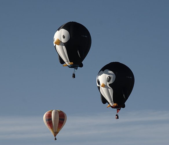
This year there were something like 500 balloons. Not all of them participate in the mass ascension. Technically, they do. But some just inflate and remain static. Others do a short hop from one end of the park to the other. The box wind was working today, and we saw several balloons make one or two laps before landing on the field.

The first batch of balloons to launch are called the dawn patrol. These take off before dawn. Each balloon has a green light hanging from the bottom of the gondola. During inflation they’re a presence that is more felt than seen; shadows that blot out the lights on the horizon. The balloons are only visible when their burners are on, which may only be a minute or two each.

Just after the dawn patrol launches, one or two balloons take off hanging US flags from their gondolas. The national anthem is played over the PA system and we stand, caps off, hands on hearts. Nobody wants to hear me sing.

Then things get rolling in earnest. It takes a fair amount of space to set up a balloon, so they’re launched in two waves. Some spread everything out on a giant tarp. Unroll the envelope (that’s what the balloon itself is called), lay the gondola on it’s side. Use a giant fan to fill the envelope with air. When it’s full, the pilot gets in the gondola (still on its side) and hits the gas to heat it up. A few blasts and it stands itself upright. Passengers, if any, climb in. The launch director blows her whistle and makes sure nobody is in the way and off they go.
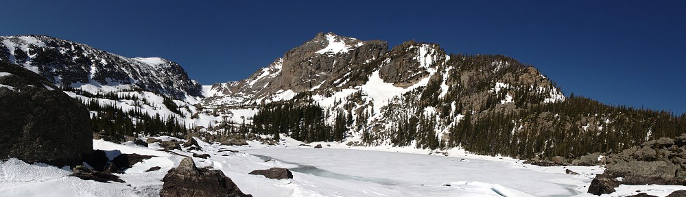
IMG_1737_stitch_crop_resize

Panorama

Sandia Mountain is east of Albuquerque, so the field is in shadow for quite some time after sunrise. Eventually the sun hits the balloons and their colors really pop. They’re often so close together, one balloon will put another in eclipse.

After all the balloons went up, we made a quick pass through the vendor area. I didn’t see any t-shirts I liked. Watched a couple minutes of chain saw carving exhibition. Nothing goes with hot air balloons quite like chainsaws. We stayed until about 10am. By then, many balloons had landed in the park. Others were scattered far to the north, west, and south. There was almost no traffic when we left; our parking lot was two-thirds empty.

Too early for lunch, we headed to the National Museum of Nuclear Science & History.

It’s at Kirtland AFB. Well, it used to be there; now it’s nearby. While the museum at Los Alamos was geared to the Manhattan Project, this one is somewhat more general. Its primary focus is on nuclear weapons and the cold war, it includes exhibits on nuclear waste transportation, atomic culture, and energy. Outside they have a large dirt area full of weapons and delivery systems: B-29, B-47, B-52, Ohio class subamarine (!), and a comprehensive collection of bombs and missiles.

IMG_1900_stitch_crop_resize

All the planes face east

After the museum we opted for a late lunch. I was looking for a good salad. I hadn’t had much luck in that search at the brew pubs we’d visited so I suggested the Council Room at the Sandia Resort and Casino, where I’ve eaten many times. It wasn’t too far out of the way as our hotel was more or less due west of there. After lunch we went back to the hotel to recharge Jerry’s phone. I transferred photos from the camera to the laptop.

We didn’t want to get stuck in a big traffic jam again so we headed back to the balloon park at five. We parked in the same lot as this morning; it was easy access and we had a quick exit. There was almost no traffic and we were there in plenty of time. We still had quite a bit of time before sunset so we went looking for a beer. There was only one place, and that had a long line. They were only letting people in as others left. We opted for soft drinks instead.

IMG_1923s

Sunset

When we attended back in the eighties, they made liberal use of a PA system. This time it must have been radio communication to the balloon pilots. They used to announce: “Everybody glow!” “Special shapes glow!” “Pulse glow!” Tonight we couldn’t hear any such announcements so everything took us by surprise. Because the balloons were neither taking off nor tethered, the balloonists couldn’t light up for very long and there are several minutes between shots. We had a nice spot near the center of the park in a fairly large void. That gave us good views all around. By sheer luck we might have been in the best spot in the park. When the balloons are glowing they’re like giant Christmas lights.

IMG_1937s

Glow!

When we thought everything was over we headed back to the car. About half way to the car the fireworks started. I’d forgotten all about that part of the show. We were in the RV park but had a fairly good view anyway. Would have been better had we stayed where we were, but so it goes. At least we’d get a jump on exiting the area. Unfortunately, we didn’t have a big enough head start. Traffic was really bad, or our parking lot was not well situated for traffic to leave, or both. It was a lesson in powers of two: at every merge point people were good enough to take turns. But we were five merge points away from the main road. It took us an hour just to get out of the lot.

Because we had a late lunch and no dinner, it was time for a snack. Jerry needed to get cash at an ATM. From our stop at the Turtle Mountain pub yesterday we knew where to find one from his bank. This was conveniently next door to the Fat Squirrel pub so we headed that way. The ATM was out of order, but the chicken quesadilla at the pub hit the spot. It was after 10 by the time we made it back to the hotel.

Albuquerque, Day 1

Every year in early October, Albuquerque holds the largest hot air balloon event in the world. It’s one of the most photographed events in the world, and it’s the only balloon event where spectators are allowed in the launch area. I attended twice, back in ’88 and ’89, with Jerry, who lived in Albuquerque for a few years. That was half a lifetime ago; it’s time to go again.

Jerry was up for a return visit: time for a road trip. I made hotel reservations a couple months ago and planned our routes. It’s a seven hour drive by interstate, plus stops, but it’s against the rules to make a Lotus road trip on the Interstate. And I’m not a big fan of going the same way all the time, so we’d have a couple of long drives. So it goes.

Friday, October 9

I picked up Jerry at 8am. He’s back in the neighborhood where we grew up. When we lived there we parked the trailer at an RV park on the Arkansas river in Nathrop for a few summers. We made that trip dozens of times. Dad always filled up the car at a gas station near Hampton and Lowell where the pumps took tokens. At Turkey Creek canyon the road went down to two lanes. It was much curvier and had a lower speed limit back then. It took us three hours to get to Nathrop. A trip to the Sand Dunes was five.

Today, it’s four hours to Alamosa. I’ve made that drive so many times it’s easy to take it for granted. But most of it is fairly spectacular. Once you get over Kenosha pass, it’s wide-open views the entire way. Many of the mountains on the west side of South Park are 14ers; they just don’t seem so big because South Park is so high. Coming down Trout Creek pass Mt. Princeton dominates the view. It and Antero and Shavano are impressive 14ers. And nine of the Sangre de Christos, from Poncha pass south, are 14ers.

It’s the tail end of aspen season. In South Park, most of the aspen have already been stripped of their gold by the wind. Along the rivers the cottonwood still had their leaves, mostly yellow with a touch of green. We seemed to go back in time as we went south. The cottonwoods became greener; the aspen regained their leaves. By the end of the day, in Albuquerque the cottonwood are only beginning to turn.

We arrived in Alamosa promptly at noon and stopped at the San Luis Valley Brewing Company for lunch. The restaurant occupies a former bank building – the old vault door is behind the bar. Pretty cool. None of their salads interested me so I opted for the Andouille Cajun Pork (sliced and served on wild rice with red & green peppers, onions and Southern au jus) and a pint of their Alamosa Amber. Their sausages are locally made – from the Gosar Ranch in Monte Vista. Good stuff.

When we were getting back in the car an old van pulled into a nearby parking spot. It was covered with bulging eyes: dozens of them, four or five inches across. Blue eyes, green eyes, eyes with long lashes.

After Alamosa we stopped briefly at Conejos, the location of Colorado’s oldest church. I was thinking there was a 16th century church in Antonito but before getting to Antonito we followed a sign (“Oldest Church in Colorado”) to Conejos. There we found the Our Lady of Guadalupe Church. It looks brand new – quite well preserved for a 16th century edifice. Except that it’s not. It was actually built in the 19th century, burned down and rebuilt in the 1920’s. So it’s a bit of misdirection to say it’s the oldest church in the state.

Back on the road, we passed through Antonito. At the south side of town is the western terminus of the narrow gauge Combres and Toltec railroad. Five or six miles later we enter New Mexico. The terrain transitions from farmland to ranch land to high desert before finally becoming a pine forest. The road is a series of straight stretches, 4 to 6 miles long joined by slight bends. In Colorado, the road is not only straight but level. Here in New Mexico it’s no longer level, cutting straight lines across the rising and falling terrain. There are no river crossings here, not even any culverts. The road is pretty much built without fills or cuts.

At Tres Piedras, US 285 junctions with US 64. Today we continue south on 285. On our return trip, we’ll be arriving here from the east on 64. So here we begin a giant loop. When we entered New Mexico we also entered Carson National Forest. All along the highway cars were parked next to the fences twenty yards off the road, their occupants in the trees collecting piñon nuts.

In Española we reach the junction with NM 30 and head south. From here to Albuquerque are new roads for me. We take NM 30 south for several miles, paralleling the Rio Grande river.  Our next navigation point is the junction with NM 502, which takes us west to Los Alamos.

Los Alamos sits on a series of mesas separated by steep, deep canyons. The road climbs from the Rio Grande valley to the top of one of these finger-like mesas and deposits us at the top, alongside the airport. Behind Los Alamos is a range of mountains. The mountains seem to be covered by a sort of stubble. This stubble is limbless, dead trees -the result of the Las Conchas fire of 2011. At the time, this was the largest fire in New Mexico history, 150,000 acres burned.

We headed to the historic district, looking for the Los Alamos Historical Museum. I didn’t have the address on our notes – it was a late addition to the itinerary. I figured it would be easy enough to find; a minor navigational exercise we’d attempt old-school, no GPS. We did see a sign for it so we knew we were close. Somehow we never saw the museum or another sign. Clearly having missed it, I pulled over and resorted to GPS. Having failed our little test, Google penalized us by sending us through the drive-through book drop of the local library to get us to our destination.

The Los Alamos Historical Museum is small, but packed with exhibits. About half are for the Manhattan Project and the rest for general history of the area. The place was fairly well packed, with most visitors in the Manhattan Project area. I’d have liked to spend more time looking at things here, but it was just too crowded.

After the museum, we go over a big bridge and NM 502 turns into NM 501. We pass through a sort of toll booth. We’re not actually entering any facility or restricted area, as far as I can tell, but I’m asked for my drivers license. “That’s all, you can go.” If this was an entrance, there was no exit. Only southbound cars were stopped.

Many of the street names in the area are a-bomb related: Bikini Atoll Rd., Trinity Drive, Oppenheimer Dr.

NM 501 ends at a T-junction with NM 4. We head west and immediately start climbing the ridge that runs north/south behind Los Alamos. This takes us along the southern border of the Bandelier National Monument. The area to our left, south, has been mostly burned. The road climbs fairly steadily, a nice Lotus road, and we soon arrive at the Valles Caldera National Preserve. It’s almost a miniature South Park – a flat, high, treeless valley surrounded by tree lined slopes. Miniature: only a few miles across and no big mountains.

Next the road turns to the south and drops the better part of 2,000 feet through red rock cliffs and red soil. Though technically we’re still in the Carson National Forest, the reality is we’re crossing from montane to desert. The road drops through the Jemez Pueblo and into San Ysidro. We gas up here for the final blast southeast on US 550 to Rio Rancho.

After checking in at the hotel we headed out in search of dinner. We ended up at the Turtle Mountain Brewing Company. The parking lot was packed and there was a wait for seats inside. We sat outside; a bit on the cool side, but not uncomfortable. Jerry had pizza, I chose a calzone.