The route back was the same as the route there, with two exceptions. I drove to Heber City via I-80 and US 191 instead of the slow, scenic route through the park. And on the other end, I took US 40 from Kremmling to Granby and over Berthoud Pass rather than through Silverthorne and the Eisenhower tunnel.
When I was just about to Heber City, I realized that I’d left my LOG 35 cap in the hotel room. I can picture it exactly as I left it: right next to the room phone, with a cloth mask in it. I called the hotel when I got home, but they say housekeeping didn’t find anything.
Coming over Rabbit Ears Pass, I encountered a few cars that were running in the Colorado Grand. The first one was an early Porsche. I don’t know that I’d have spotted him if he hadn’t waved at me. Next was a red Ferrari. There was a yellow one, I didn’t get a good look at it, could have been a Morgan. Finally, a Mercedes I think was lost. He was at the stop sign at the junction with CO 14 and pulled out and followed me. All the other guys were going the other way. He turned around before he went too far.
The drive from Kremmling to Granby was new to me. Byers Canyon is nice, if a little short.
I was pleasantly surprised throughout the day that the truck traffic was considerably less than on Friday. Auto traffic was pretty bad from Granby to home, exacerbated by showers from Winter Park to Golden. I didn’t actually get rained on until Idaho Springs or so, but all of Berthoud Pass was wet, and the cars kicked up a lot of spray. I’d say it improved when I caught up to the rain, but then puddles made me a little nervous.
My trip home took about half an hour less than Friday’s drive.
So that’s the story.
Now, two final thoughts.
Where Did the Oil Go?
Michael figured it out right away when I told him what Dave and TJ said. Dave and TJ would have figured it out had I thought to tell them that we did an engine swap over the winter.
Of course, the cooler and lines drained when we pulled the old motor out. So they’re empty. When we filled the new engine with oil, it didn’t fill the cooler because the thermostat was closed. It doesn’t open until I put it under “track conditions”, whatever that means. When it opens, the cooler fills with oil and we’re suddenly two or two and a half quarts low.
The problem with that theory is that when I put one quart of oil into the car, I was able to run a 12 lap session and get 3 laps in another session before having the problem again. I guess that means there was an air bubble in the cooler that didn’t come out until the heat from the 12 lap session worked it out.
Which only leads to the next problem: this was not my first track day after the engine swap.
I’ve done 4 track days at HPR. Not a lot of laps: 90 laps over 12 sessions. One day was a Thursday Evening event, one was a half-day in April, one “session” was the RMVR Ticket to Ride. And the Ferrari day. How did I run 90 laps at HPR and not put it under “track conditions”?
Things that make you go “hmmmm”.
I have now put three quarts of oil in and all is good. If I was half a quart low when I left the house and the cooler uses two and a half, that’s the three. I’m reasonably certain I’m good to go now, but I won’t know until the next time I take it to the track. (And maybe not even then.)
I never put more than a quart in at a time to get the dipstick to read full or nearly full. I’m assuming that I went from full to a quart low in an instant on the track, when I could get on the high cam one moment but not the next. The distance driven at a quart low was fairly limited and at low revs.
I’ve done more than fifty track days and I’ve never had any need for brake fluid or motor oil. Needed both in one day.
LOG 40 Reflections
The pandemic took a bit of a toll on this LOG. It was supposed to happen last year, but we all know what happened. Some things just couldn’t be overcome, like the travel restrictions. I was looking forward to seeing the speakers live. I hoped to see the Evija and the Emira. I’d be lying if I said I wasn’t a little disappointed.
I often get lazy and refer to “the Lotus club”. But really, the cars are the excuse to meet people. It’s not a club of cars, it’s a club of people who share a passion for cars.
I met quite a few really nice people. How’s that not a good time?
I repeat: I met quite a few really interesting, accomplished, nice people. I had a great time, even if it wasn’t perfect.
Unless I want to leave the hotel, I’m pretty much limited to Starbucks. Luckily, they have more kinds of sandwiches than I’ll have mornings here, so no repeats are necessary. I sat down to eat my sandwich in front of the TV, which was showing the F1 race. I only missed the first ten laps. I’m so happy the cars have the halos. That halo saved Hamilton’s life, no doubt in my mind. The race kept me entertained until it was nearly time to meet for the guided group drive to the ghost town of Eureka City.
The fellow running the drive collected us in the lobby at 10. (I will refer to him from now on as Speedy Gonzales, SG for short.) He gave us a short description of Eureka City and talked about the historian who will meet us there. The museum is normally closed on Sundays, as is the restaurant, but both will be open for us. He then described the route. Somebody pointed out that his route doesn’t match the route that was published. Obviously, nobody was carrying paper and pencil, so nobody took notes. He told us, “You’ll just have to keep up.”
Exiting the hotel, I was near the end of the train, but at our first red light I switched from the center lane to the right lane. It wasn’t that I wanted to get to the front of the line but more that I didn’t want the line to be so long, people would miss the light. When the light turned green, I was third in line. A couple of miles later, we got on the interstate and were soon going quite fast. I use a speedometer app on my phone. It keeps track of driving time, total distance, average speed, and so on. It recorded a maximum speed of 98. This was on the interstate in south suburban SLC. I like to go fast, too, but that’s why I do the track day. I think we lost half the group within five minutes of leaving the hotel.
We exited the interstate and Bobbi pulled up next to me at the light. I hollered, “Does he know people are trying to follow him?” She replied, “I don’t think he gives a shit!” He didn’t make things any better when, shortly after getting on UT 68, he stopped for gas. The experienced drive leader will tell everybody to be gassed up when we meet or will arrange to meet at a gas station so folks can top off their tanks if needed. SG was the only one who needed to fill up, but I took advantage and made a comfort break and bought a beverage so it wasn’t a total waste.
When we were all ready to leave, a bunch of us LOCOs decided to make our own way and stayed at the gas station for a few minutes. Wayne was quite familiar with the area, so we put him in the lead. To our surprise, SG and the few cars that went with him were waiting for us on the side of the road not far from the station.
UT 68 goes south alongside the western shore of Utah Lake. It’s a fairly scenic drive, with a view of the lake and the Wasatch mountains behind it. I couldn’t help but wonder if it was a salt lake, too. (I learn later that it’s a freshwater lake that is a bit saline because two-fifths of its outflow is evaporation.) Unfortunately, we were again going at a pretty good clip, not as fast as before, but still too fast to enjoy the scenery. It’s not a curvy road, but there are some bunny-hops that add a little lightness.
We stopped at the junction with US 6. We pulled into the parking lot of a defunct gas station. SG had mentioned the rustic ruins of a station where he had taken pictures of his car, but this didn’t look that photogenic to me. And we were all jammed in together, so I’m not sure what sort of photo one could get. In any event, nobody got out of their cars. We got going again, heading west on US 6. (On the return trip I think I figured it out: the rustic station was on the other side of US 6 from where we parked.)
Not long after, we arrived in Eureka City. It’s not what I’d call a “ghost town”. It has a population of about 700, has a nice new post office, a couple of restaurants, a museum, and a high school. And, driving around, we saw quite a few new or nearly new houses. When I think ghost town, I think nobody lives there. This, to me, seemed more like Central City before the gambling, without the tourists. A ghost of its former self, but not a ghost town.
We met our local historian who launched into his spiel. About ten minutes later, the cars we lost back at the start of the drive showed up. With everybody assembled, after a brief introduction, we followed him up the hill to one of the mines. We were parked everywhere. One of the homeowners invited six of us to park in his driveway.
The mine itself is sealed, looks like an unpaved parking lot now. There’s a tall stake in the middle, with a series of painted markings. “That tells us if it’s sinking.” The EPA did quite a bit of work here. They took the top eighteen inches of topsoil of every lot in town (if you can call it “topsoil”). Many of the old mine buildings are still standing, and still full of derelict equipment. He took us through one, the hoist building.
This held the machinery that ran the lifts to get the miners in and out of the mine. It was dark inside, too dark to shoot pictures with the SLR. The floor was covered with debris, lots of broken glass. In one area, everything looked to be covered with feathers. I don’t think it was feathers, though, because I didn’t see or smell any bird shit. Mostly it was just dusty.
It was quite interesting, so, in spite of the problematic drive down there, it was good in the end.
After the mine “tour”, we headed to the restaurant. Somehow, I managed to get there almost last. I was the second to last to get served. I had a raspberry shake, which is strictly off the diet. It was tasty, and I only ate half. I sat at a table with three other folks, a nice couple from Scottsdale and a doctor who lives in New York but had worked for a while in Denver. Nice folks.
Most folks went to the museum after eating, but by the time I was done, it was getting pretty late and I elected to pass on the museum. I wasn’t alone – our little LOCO breakaway group was still there. We let Wayne lead us back to the hotel. We weren’t going a million miles an hour, so I enjoyed the drive a bit more. We were a small group now; the most common car was the Evora, and all three were yellow.
Evora with “track pack”
Hoist room
Hoist room
Electrical machinery
Driving shot…
Tonight’s agenda at the hotel was a buffet dinner and a virtual tour through Classic Team Lotus.
The buffet was in the same room as last night’s banquet. I figured I’d just sit at the same table as last night, but the seating chart by the door was a bit different. I’m not sure it was the same chart. Did I miss seeing two of these things? My table from last night was full tonight, so I looked for another table that had some open slots. Again, I wasn’t carrying a writing utensil, so couldn’t write my name in the appropriate blank.
I found myself sitting next to Richard and his wife, Sandy, who I visited with last night. After I sat down, a couple came in and claimed two empty chairs and went off searching for food and/or drink. While they were gone, another couple came in. They were chagrined to find that there all the seats but one were taken. They had signed up on the chart to sit here. As I hadn’t, I told them to take my seat. They insisted that I remain where I was and they found another table. I felt a little bad.
The entertainment this evening was a virtual tour of Classic Team Lotus. Richard Parramint did the tour for us, which was quite kind of him, as it was about one in the morning his time. As is usual with these things, it took a few minutes to get through the technical difficulties, but once he got going, all was good. They’re working on quite an interesting bunch of cars at the moment. But then again, I’m sure they’re always working on an interesting bunch of cars.
This is the end of the festivities for most LOG attendees. I, however, have one more day: the track day at Utah Motorsports Campus.
To that end, we had a drivers meeting in one of the conference rooms after the buffet. It’s not the same sort of drivers meeting we get at the track and not a substitution for that meeting. Here, we were handed our tech forms, told when to arrive at the track, got a count of cars by group (novice, intermediate, advanced) and based on that data decided to combine advanced and intermediate. I applauded this move. With three groups, we’d be having 20-minute sessions. I much prefer 30-minute sessions as a much smaller portion of your time is spent on in and out laps.
Our friend Speedy Gonzales ran the meeting. He made a point to stress, repeatedly, that we shouldn’t try to impress the instructors. He told us he had hundreds of hours racing Formula Fords, and nothing we could do would impress him or the instructors, and may, in fact, just scare them. So we were supposed to be on our best behavior. I wasn’t too concerned with this topic, as I won’t be needing an instructor and I always try to be on my best behavior when I’m on the track.
The last thing we were told was to get a good night’s sleep. I’m down for that!
Every year, unless there’s a pandemic, anyway, Lotus Ltd, the national Lotus owners group, holds a Lotus Owners Gathering. These events are hosted by whatever local chapter wants to step up to the plate. The only LOG I’ve attended so far was the one we hosted in Colorado Springs. Most often, they’re deep in the Eastern time zone and I’ve been reluctant to make the drive. In 2020, the fine folks in Salt Lake City took on the challenge. COVID saw that challenge and said, “Not this year!” so it was postponed to 2021, where we begin our story.
I wasn’t the only one from Lotus Colorado, as you might expect. The LOCO gang is pretty devoted to group drives, so a two-day drive was organized for the trip to SLC and there was a choice of two drives for the return trip, one of which was several days and hits several national parks, including a visit to the north rim of the Grand Canyon. Unfortunately, I just started a new job and had to minimize time off, so I did the travel on my own.
Friday, September 10
I left the house at 6 am and headed up I-70 to Silverthorne. Yes, this is a violation of Rule #1. There is a fairly limited number of routes from Denver to Salt Lake City. Most people tend to use I-80. I-70 is another choice. Other than interstates, your choice is pretty much down to Trail Ridge Road and Poudre Canyon. Both are nice drives, but each would add a significant amount of time to the trip.
Between the two interstates, the next most obvious route is US 40. It covers the vast majority of miles between the two terminals, with a short stint on I-70 on the Denver end and I-80 on the SLC end. I drive the section of US 40 between its intersection with I-70 and the western end of Trail Ridge Road in Granby fairly often. A variation of this trip would be to forego Berthoud Pass and continue on I-70 to Silverthorne. From there, take CO 9 north to Kremmling. That’s a new road for me, so I went that way.
I stopped for breakfast at a bagel place in Silverthorne. There, I had a short visit with a couple visiting the area from Portland. They began the conversation by saying that they liked my car because it matches the colors of the University of Oregon.
From the top of Hoosier Pass south of Breckenridge to Kremmling, CO 9 runs downhill beside the Blue River, a tributary of the Colorado. There are two dams on the Blue, Dillon Reservoir and Green Mountain Reservoir, dividing the valley into thirds. The twenty miles from Silverthorne to Green Mountain Reservoir runs along a spectacular string of 12 and 13,000 peaks run to our left. After Green Mountain Reservoir, the valley flattens and widens. Here, trees are only growing on the slopes and the valley floor is fairly barren. North from Kremmling, we climb along Muddy Creek, which is dammed by Wolford Mountain Reservoir just a couple miles from town. Thirty miles up the road we reach Muddy Pass and the junction with CO 14.
John C. Frémont explored this area in 1844, crossing Muddy Pass, heading south. He wanted to search for the unknown source of the Colorado River but “a mob of Arapahoes in war paint” appeared from the east. His men swam their horses across the river and hustled up the Blue River to where Dillon Reservoir is. With Arapahoes everywhere in the woods now (who were actually looking to pick a fight with the Utes), they hurried up Hoosier Pass. Twelve years later, Frémont was the first Republican candidate for president.
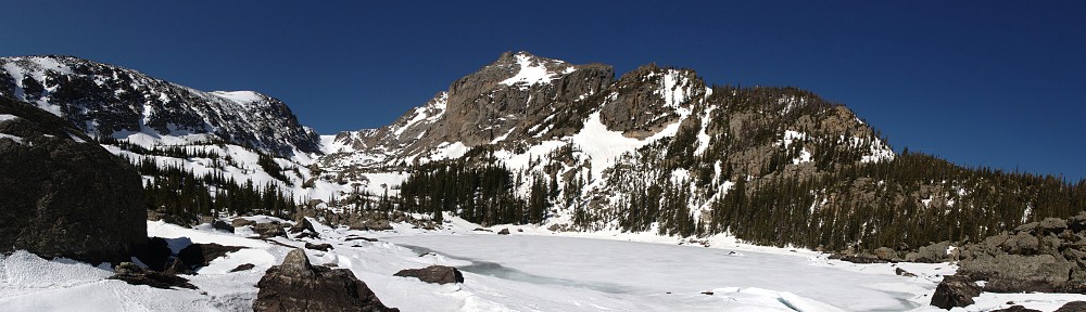
Passing the junction with CO 14, we start to climb the eastern side of Rabbit Ears Pass. Typically, the top of a pass is a crest. Here it’s a plateau. The road runs nearly level at about 9,400′ for about four and a half miles. Drop down the west side of Rabbit Ears to Steamboat Springs, and onto the Colorado Plateau, which we’ll cross for most of the rest of the day.
Life Elevated
We follow US 40 west until Heber City, Utah. Traffic was about as light as I expected until I got to Vernal, where I had lunch. I was not terribly happy with the traffic from Vernal to Heber City. The road is nice enough: a good surface, with just about every significant climb having a passing lane. But the traffic west of Vernal was not to my liking. Lots of trucks running in both directions. I don’t know what they’re carrying, but they’re the ones that look like inverted cones, running in tandem, 38-wheelers.
Between Starvation State Park and Strawberry Reservoir, I just missed a rain squall. I’d have rather driven through the squall than missed it: the road was wet and the big trucks kicked up huge clouds of spray. So much for having a clean car.
At Heber City, Google wants me to go to I-80, but I’d rather not. Instead, I find a route through Wasatch Mountain State Park. I enjoyed this little trek: Pine Canyon Drive, S Guardsman Pass Road, and Big Cottonwood Canyon Road. Those first two were narrow, steep, and windy with no center stripe and a 15mph speed limit. Which is about right: I encountered a deer and a Bighorn Sheep ewe standing on the road.
I pulled into the hotel parking lot at 4:20 and was directed where to park: drive under the limbo pole, past the Evoras and Elans and Europas, into the upper part of the lot with the Exiges and finally my Elise brethren. I wasn’t the last to arrive, but nearly so. As usual, I have the dirtiest car in the group. Everybody who needed it washed their cars at the hotel. I barely had time to check into LOG and into the hotel before it was time for the Gathering of Lotus Owners.
Out in a tent on the back lawn, we had some food and a cash bar. Soft taco fixins, chips and various dips. A local brewery made a Lotus Lager available. I think it was more like an amber ale. I like amber ales, so I had two Lotus Lagers. Somehow, I managed to gather with other LOCOs, which I don’t have to drive 600 miles to do. I resolved to mingle as much as possible with people who haven’t already heard all my stories.
Our last sojourn with the club was spring of last year. If I’m counting correctly, that means we missed two trips since then. So we’re due for a weekend outing. This time we’re sticking closer to home and shortening the trip to two days/one night.
Mike has now put so many of these trips together that he’s probably driven every paved mile of every state and US route west of I-25 at least twice, and certainly many miles of county road as well. His routes are well designed and documented, and thoroughly scouted. Thanks Mike!
Saturday, September 28
Our rally point was an Alta station in Woodland Park. A quick drivers meeting at 9:45 for a 10:00 departure. We left the house at 7:30 and would grab breakfast and stop at a Subway to make our picnic lunch on the way. We hit the superslab and went through the Springs. This may have been our first suboptimal decision. I think the route through Deckers is as fast, but I figured food would be easier the other way.
I’m not a big fan of Interstates to start with. But the stretch between Denver and Colorado Springs is at the top of the list of Interstates I particularly dislike. There’s been too much traffic for twenty-five years and it only gets worse. A bunch of people go too fast, and another bunch never gets out of the left lane. Now the level of difficulty has been bumped up with a twenty-one mile stretch of construction: narrow lanes, lane diversions, concrete barriers, reduced speed limits.
But today is a beautiful, clear Saturday morning in early fall and perhaps a lower than average number of inattentive drivers are out and about. The worst offenders today are the ones who you catch up to at a steady rate but speed up when you go to pass them. If that’s the worst behavior we encounter all weekend, that would be great.
We had a fast food breakfast, got our picnic lunches, and made it to the rendezvous with time to spare.
This trip is not only 2/3 of the normal duration, but about 2/3 of the normal number of cars. The Lotus contingent is a Europa, four Elises (one each of red, yellow, green and blue), and a Westfield 7. In theory, we could have had two more Elises, both orange, but the passenger count required larger vehicles so two M series BMW’s were substituted (an M4 and an X3). Also on the substitution list were two Esprits. One went down with an electrical problem a few days ago, so it is replaced by a Range Rover. The other is an X180R and is not as well-suited to these trips as the Jaguar XK-R. And, finally, a sharp, sporty Cadillac piloted by a former Elise owner.
Our first stop was the Florissant Fossil Beds National Monument. It might be natural to try to compare Dinosaur National Monument to this place, but they’re not at all the same. Florissant is six thousand acres of sub-alpine forest, while Dinosaur is high desert with deep canyons and is thirty-five times bigger. Forissant’s treasures are 34 million years old, a world dominated by mammals, while Dinosaur’s are, well, dinosaurs.
Only photo I have that shows the scale of these stumps
Thirty four million years ago, the Florissant area was prime lakeside land in a forest of giant redwood trees. Then a nearby volcano erupted and filled the place with lahar and ash, preserving the stumps of the giant trees. In addition to the giant stumps, there are layers of “paper shale” that hold fine specimens of plant and insect fossils.
The place has a smallish visitor center. There are displays that describe the geology and have examples of the fossils and interactive dioramas. There’s also the usual gift shop. Outside, there is a set of large stumps with roofs over them, and several trails that go out into the fields. We took the one mile loop and saw a number of the stumps in various conditions.
The fossil beds were notorious a century ago and people came from all around to take home pieces of the stumps. The place was comprehensively looted. As late as 1956 it was still going on. Walt Disney visited Florissant and arranged to buy one of the stumps. I understand it’s still on display at Frontierland.
After a bit more than an hour at Florissant we hit the road for Victor and Cripple Creek. These were flourishing towns in the gold rush days. In those days, most of the fortunes were made by the people who supplied and supported the miners, rather than the miners themselves. A story I find amusing is that of the guy, building his hotel in Victor, who struck gold digging the foundations.
Cripple Creek has lived on tourism and gambling for decades, but gold mining made a bit of a comeback. The road from Victor to Cripple Creek passes around the Cripple Creek and Victor Gold Mine, operated by Newmont Goldcorp. Newmont is the second largest producer of gold in the world, but this is not one of their larger operations. It is large enough, though, that I expect the mine to completely level a mountain.
We had our picnic lunches at a park in Cripple Creek. They had a festival going on, with the main drag downtown closed to traffic. A stage was a the top of the road with a live band playing sixties radio fare. Lots of the usual sorts of vendors, and a few food trucks. We’d heard that there was a car show, but we missed it. We did see another group pass through: a few Corvettes and a Ford GT.
“Acclaimed all over the world”
Our third leg of the day takes us to the Royal Gorge over a series of Teller County roads. Much of this leg was on roads I’d never been over before. There wasn’t much traffic. We weren’t going particularly fast, but it’s always nicer to pick our own pace.
At one time, the Royal Gorge was the highest suspension bridge in the world at nearly a thousand feet above the river. There are now a couple higher bridges in China. Those probably are used to get from one place to another. The Royal Gorge, though, is a bridge to nowhere. When I was a kid, you could still drive across it. Even then there wasn’t anyplace to go on the other side: you had to cross back over the bridge.
Today, of course, it’s pedestrian traffic only. I haven’t been here since I was a kid, and nothing was familiar except the bridge. A forest fire burned through the area a few years ago. It burned some of the facilities but not the bridge. So the place is mostly brand new, with a large visitor center and a number of thrill rides on the other side. We didn’t stop for very long: get some photos, walk around, take a comfort break.
From the Royal Gorge we headed west on US 50 to Salida and our lodgings for the night. We’ve been seeing a surprisingly large number of RVs so I expected to get held up in the canyon. But there are several passing lanes and the only RV we came across pulled over after two of us passed it.
Approaching Salida we ran into a construction zone that had several sections of unpaved road. We also started to smell smoke. The Decker fire is burning nearby. It’s not a particularly big fire, having burned about 1,500 acres (so far). It was started by lightning and is burning an area with lots of beetle-kill. We saw fire fighter trucks from various places; the fire is only about 5% contained but the forecast is for strong winds, so that won’t help.
We had dinner at the Boathouse Cantina. They made room for our large group near the front door. The room was dark enough to make reading the menu difficult, but we managed to decide what we wanted. Genae had the scallops while I had the tacos al pastor (pork and pineapple with jalapeno and cilantro, with a slice of lime).
Sunday, September 29
We’d spend the morning driving: over Monarch pass to Gunnison, then north through Almont, past Taylor Park Reservoir, and over the newly-paved Cottonwood pass to Buena Vista. While I enjoyed our visits to the fossil beds and the bridge, I most anticipated the drive over Cottonwood pass and it ended up being the highlight of the trip for me.
Decker fire
Genae jokingly (I think) suggested we hit the pancake house down the street. Somebody else did go there; said it’s a crowded place and you have to get there early. I wasn’t going anywhere early. Breakfast in the hotel was underwhelming. Their bagels were miniature, too small to put in the toaster. Almost everything else on offer was sugary. So I had toast.
Down to ten cars with the departure of the Cadillac, we were were a relatively easy group to wrangle. Everybody was ready to go. We left promptly at 8:30. We’ve done the drive from Salida to Gunnison a number of times. We had very little traffic this time, which is nice, but Monarch Pass is a fairly run-of-the-mill road.
Part of the fun of the trip is to see the aspen. Yesterday, I’d say the aspen looked a lot like my car: mostly green with some yellow. Today there was more yellow, so much more scenic. The western side of Monarch is grassy, with cottonwood near the water. The cottonwoods had turned, a bit more gold compared to the yellow of the aspen.
To get to Cottonwood Pass, head north out of Gunnison to the confluence of the East River and Taylor River. This confluence forms the Gunnison River. From here it’s county roads to all the way until it turns into Main Street in Buena Vista.
Taylor canyon is quite pretty. The river is still flowing nicely, and the road is often close to it. It is open range, so there are quite a few cattle guards. I’ve driven many miles through open range and rarely see cattle. Today there were some, right on the side of the road when we resumed after a short rest stop.
At Taylor Park Reservoir
Cottonwood Pass doesn’t have a storied history. No notable expeditions of exploration crossed here, no railroad conquered it. And only this year did it finally get paved. It is now the highest paved through road in the state. Only the roads to the summits of Mt. Evans and Pikes Peak are higher. The road was built in spring of 1880. Nearby Tincup Pass got a road at about the same time, but although Cottonwood is higher, it was used more than Tincup because of the gentler grade.
Cottonwood Pass has some character. Almost all the passes in Colorado on US highways have been widened and straightened to handle high traffic loads. Wolf Creek used to be so treacherous they wrote songs about it. Today it’s three or four lanes all the way over the pass. Cottonwood still has a healthy number of hairpin turns, even if it lacks precipitous drops. It’s twisty and turny: a nice Lotus road.
East side of Cottonwood Pass
The road crosses the Continental Divide Trail at the summit and the Colorado Trail a few miles down the west side. I was expecting to see another crossing on the east side as well. The CT splits: hikers can use either the Collegiate East option or Collegiate West. Each is 80 miles, and we’re passing between Mt. Yale and Mt. Princeton. It doesn’t get much more collegiate than that.
At the summit we parked next to a small SUV with writing all over the back windows: “Triple Crown AP 2017 PCT 2018 CT 2019”. Seems to me they’re running a bit late. Certainly, if they’re only this far on their way north they won’t finish.
Roadside colors
We arrived in Buena Vista about noon. We split from the group here. The itinerary called for a lunch stop here for an hour and a half or so, followed by everybody going their respective ways: the Springs folks down US 24, the Denver people down US 285. This is where we made our second suboptimal decision. We left early and went north to I-70.
This takes us through Leadville and over Fremont Pass and by the Climax mine. We stopped in Silverthorne for lunch. The electronic signs near the Dillon exit indicated “Up to 90 minutes to Denver”. That’s not bad. With no traffic it takes an hour. So thirty minutes of delays on a Sunday afternoon doesn’t sound too bad. And “up to” means it could be less, right?
Only that’s not how it turned out. It took us half an hour just to get to the tunnel. Then it was stop-and-go off and on to US 6. We’d have been much better off going 285. So it goes.
It was a really nice weekend. Big thanks to Mike for all the effort he puts in.
Slightly late start to the day. On weekends the hotel starts breakfast at 7 instead of 6. My plan was to have the car loaded before 7 so I could be out as early as possible without skipping breakfast but my route planning took a bit longer than expected.
First leg of the trip was to Clinton, Iowa, where I wanted to take a short break at a park by the Mississippi River. I took two lane roads almost the entire way; very easy driving. The park in Clinton was a hive of activity with some softball games going on. I walked maybe a half mile down the river, then back. US 30 crosses the river on a suspension bridge and the rail bridge is almost at the water line. It’s one of those bridges that has a center-pivot to let river traffic go by. I didn’t see this one in operation, but later when I crossed the Missouri I saw a rail bridge pivoted and open to river traffic.
Riverview Park, Clinton, IA
From the satellite photos, this little lighthouse is generally 70 or 80 feet from the water and there are four or five more light posts that are submerged. Clearly, the levees here are high enough to handle a lot more water. But if this were to be breached, the major part of this little town would be submerged.
US 30 bridge, railroad bridge, at Clinton
The next leg of my trip was from Clinton to West Branch for a quick visit to the Herbert Hoover Presidential Library and Museum. Again, two lane roads, this time almost all state routes rather than US highways. I don’t think I had to pass anybody the whole way from Naperville, other than in the towns. I’m sure I’m sounding like a broken record when I say how much more I prefer the small roads to the interstates.
I didn’t spend a lot of time at the library. I watched the film that they show hourly and toured the exhibits in the museum. And, of course, the gift shop. For some reason, they have a bunch of trinkets related to ancient Egypt. I don’t recall Hoover having any connections, but I could be forgetting. In the museum was a hunk of the Berlin wall. Again, I’m pretty sure he had no specific connection to the Berlin wall, but it was cool to see it. In general, I don’t go around touching museum exhibits, but I couldn’t resist this time.
Most of the building is off-limits to the public, so I had to ask: If I were to be writing a book about, say, Belgian relief, could I get access to the library? The answer was that all I’d need to do is get a research license, which is about as hard to obtain as a library card. In the mean time, I was free to ask any of the staff researchers questions and they’d do their best to respond. Interesting. Not that I’m planning on writing about Hoover. Or anybody else, for that matter.
Hoover grave site
The Hoover library is only a few hundred yards from I-80. I’ve driven by here many times and never bothered to stop. Or even notice how close it was. Add this to the long list of places I ignored because I was in too big of a hurry on the Interstate. The more I avoid those roads, the happier I am.
Third leg of the day was from West Branch southwest to join US 36 somewhere in Missouri, then as far west as I could get. I had the endpoint tentatively at Bethany, Missouri. I reached Bethany before 6:00pm; clearly too early to stop. In my first iteration of the plan, weeks ago, I was looking at St. Joseph. As it turns out, I made it to Hiawatha, Kansas, about forty miles farther.
One of the reasons I don’t drive after dark is the danger of animals. This was illustrated perfectly just a few miles before Hiawatha. I came upon what I thought was debris in my lane. It wasn’t obvious to me at first what it was. Then I saw it was moving. Slowly. It was a good sized turtle, moving from left to right and about where my drivers side tires belonged. I avoided it, and the smaller turtle a few yards past it, which had almost reached the shoulder. I sure hope they both made it. Frankly, I’m a bit amazed they didn’t get clobbered by the clump of traffic about a quarter mile ahead of me: two semis, two tour buses, a motorhome, and two cars. I have no idea how they all managed to miss both turtles.
My minor irritations with technology continued. As soon as I pulled up to the hotel, my phone decided it didn’t want to talk to anybody. I had no cell service and no GPS. At first I thought it was just the cell service that was lacking. But I saw other people yakking on their phones and spotted a cell tower a short distance away. All was good after rebooting the phone. I guess the day wouldn’t have been complete without some sort of technical glitch.
One of the key events of Herbert Hoover’s tenure as Secretary of
Commerce was his relief work in the aftermath of the Great
Mississippi Flood of 1927. This was the most destructive river flood
in the history of the United States. Twenty seven thousand square
miles of land was inundated and 630,000 people were displaced from
their homes. To try to prevent future floods, the federal government
created the world’s longest system of levees and floodways.
Yesterday, one of these levees failed in the West Quincy area, and
other levees were breached along the Arkansas river as well. Luckily,
I was in neither of those places and saw nothing so dramatic.
However, I did drive by a huge amount of acreage that was under
water. Not being from the area, I can’t look at a river and tell if
it’s high compared to other severe flooding years, but every river
I saw looked very high. At Clinton, all the access stairs leading
down to the river were closed, and lampposts on the river side of the
levee were under water.
In Missouri, just east of the Mississippi, there’s the Platte River. This is not the same one that flows through Denver an on through Nebraska. I didn’t know there was another one. This one is sometimes called the Little Platte River. This Platte was well out of its banks, flooding perhaps a half mile on each side of the river. Most of Iowa and Missouri that I traversed through the day was rolling terrain, so there wasn’t much flooding to see. But quite a bit of land on the Kansas side of the Missouri is flooded as well as large areas of Illinois that I drove through. Of course, I also mentioned flooding last weekend through the section of Illinois that I went through farther south.
We aren’t in need of someone to do what Hoover did 90 years ago (feed and house more than half a million people), although there are still quite a few people affected by the high water. But I think I can say that the levee system did what it was intended to do (regardless of other good or bad side-effects). In 2011, the Mississippi rose a foot higher than back in 1927. And the flooding along the Missouri this year is worse than it was in 2011. But the damage and displacement of people is far, far less than back then.
Today’s miles: 525 road Total miles: 2,254 road, 407 track
Day 9 – Sunday, June 2
A fairly straight-forward and uneventful drive through Kansas and eastern Colorado. I well remember last year’s range anxiety on this same road. Today I filled up in Smith Center, Kansas, three hundred miles to Byers. I’d been getting a bit over 33mpg and figured I could make it easily. Just the same, I topped off the tank at my lunch stop in St. Francis, at the last working gas pump before HPR.
Today’s miles: 524 road Total miles: 2,778 road, 407 track
I was awakened during the night by a brief thundershower, but
wasn’t curious enough about the time to actually check. A lazy
morning, sleeping in and taking my time to get going. A nice
breakfast, as far as these things go (eggs, sausage, fruit, bagel).
I visited with Joan, Junior, and Susie before leaving Toledo at noon. Because I wanted to take a break at Indiana Dunes National Park it seemed expeditious to violate Rule #1 and utilize the interstate. In this case, it’s not just interstate, but turnpike. In retrospect, I’m not sure it was worth it. I had to pay $11.25 in tolls between Ohio and Indiana. There were several construction zones that slowed things down, the road surface was some of the worst of the trip, and truck traffic was so heavy they were running nose to tail in groups of six to eight the whole way. On top of that it’s monotonous; I really fought to stay awake. Back roads might have taken me thirty or forty minutes longer, but I’m sure would have been better.
I took a lunch break at one of the service plazas there. I always try to get a seat with a view of my car. Not because I want to watch the car but because I want to watch people looking at it. People go out of their way to check it out. Highlight this time was when a father took a picture of his 6 or 8 year old son standing next to it. (And another one, a few miles from my destination: in a car next to me at a light, the father asking the son if he sees my car. “It’s a green race car just like the one you have. Can you see it?” Then he turns to me and says “Nice car!”)
I’ve been fighting technology the whole trip. Navigation by phone has not let me down on the cross-country drive. (I nearly credited that to having brought an atlas with me, but that can’t be the reason because I managed to leave it in the motel in Mansfield.) But things have not been all roses. At Ruth’s I tried to bring up a map of nearby motels. It kept showing me motels in Mansfield. But I’m not in Mansfield! “Maps is off-line”. Tried to connect to her WiFi but my phone didn’t see it. Managed to find a hotel almost at random. In the hotel I couldn’t connect to the internet. But if that’s my biggest complaint on this trip, I can live with it.
On the plus side, getting through Chicago, I imagine, is much
better with the navigational aid. Had I had to do this the
old-fashioned way, I’d have picked a route before hand and had to
stick with it regardless of delays. It would have had to have been a
simple route with minimal turns. Anything complicated would require a
passenger to keep me on route. But with satnav, when there was a
delay it rerouted me, and the final route was actually quite
pleasant: along a section of the Little Calumet River and through the
Waterfall Glen Forest Reserve (passing by the Argonne National
Laboratory).
On I-94 I saw a red car stopped on the side of the road. Too late I identified it as a Ferrari. Had I seen what it was quickly enough I’d have pulled over and stopped. I’m pretty sure I’d have been totally unable to provide any assistance unless the guy’s cell phone was dead.
Today’s miles: 288 road Total miles: 1,657 road, 281 track
Diversion: Indiana Dunes National Park
This was a very brief visit, so I’m sure I’m not seeing the whole picture.
It’s an interesting little park. It lies along about fifteen miles of Lake Michigan shoreline. It’s not a big park, but it’s one of the most botanically diverse of the National Parks. It’s also one of the newest. I was wondering how I had never heard of it until I looked it up: it became a National Park in February of this year.
Great Marsh, south of the dunes
I intended to take a very short hike, about three quarters of a
mile on the Dune Ridge trail. From the map it’s pretty
straight-forward. A lollipop: hike south from the parking lot to a
junction, go to the right, make a loop, return to the junction and
take another right turn to return to the parking lot. But it wasn’t
that simple. Somehow I never made it back to the trail junction.
Instead, I found myself north of the parking lot, overlooking the
shores of Lake Michigan.
Well, that saved me the trouble of getting in the car and finding my way to the beach. And it was probably twice the distance I intended on hiking, so that’s good. I made my way down to the beach and walked west a bit. There I met a man who was clearly searching for something. I asked him what he was looking for. “Rocks. I collect interesting ones for my garden. My wife sent me out today to get more red ones!” While we chatted, he found one that looked to have some fossils in it and one that was a piece of beach glass, along with a few others of a variety of colors.
I never did see anything resembling the sort of sand dunes I had
imagined. I was thinking along the lines of actual piles of sand.
Like the Great Sand Dunes in Colorado, or the Imperial Sand Dunes in
California. These dunes are considerably different. They’re covered
with vegetation. It’s only obvious they’re sand where they’re
eroding. They have signs up saying not to walk on the dunes. The
trails I walked were sandy only in a few places. Not at all what I
expected.
Keep Off Dunes
To the south is some wetlands. I’m not sure if there’s more water there now than usual, given all the flooding I’ve seen elsewhere. The vegetation on the dunes isn’t exactly sparse; it’s like walking through a forest with lots of ferns as ground cover. Also appears to be something like blackberry brambles, although I don’t know what for sure. And they regularly do controlled burns there, so there’s lots of charred wood on the ground. I saw only a very few wildflower types and no animals. I did hear quite a few different bird songs, but never saw the birds. I understand it’s a popular place with the Chicago bird watching crowd.
I was out the door by 6:30. I grabbed a spot in the paddock and went looking for where the meeting would be. I was early and watched some of the late check-ins, including a fellow who drove his McLaren from Ontario. He didn’t have a tech sheet with him, so they gave him one. He signed it and handed it back. “You need to check the boxes”.
McLaren 600LT
Meeting was at 7:15, all the usual stuff.
In the paddock, I ran into Ken, the only other Lotus in attendance. There were several others registered, all Exiges, but all but Ken canceled. That was a little disappointing. I’m used to seeing a bigger Lotus turn out.
My paddock neighbors were Mark and Don. Mark trailered in his Corvette, Don trailered in his S2000. Both very nice gentlemen. Don had a couple of 5-gallon gas cans and before we went to lunch we used one to fill my tank, then when we went for food we refilled it so he was back to his full allotment. I was a bit surprised that I took the whole 5 gallons. From the gauge it looked like I only needed 4. After running the two afternoon sessions, I was about to pull onto the track for “happy hour” and noticed that I was reading empty and the light was on. So I didn’t run. Later, when leaving the facility, the gauge read about a third of a tank. When I fueled up, I had four gallons left in the tank. Oh well.
Our first session was under full course caution, and everybody ran. I was immediately concerned as I thought it was extremely slippery. The consensus is that it’s a low-grip track. It got better as it warmed up, and by the time my group was out conditions were about as good as they’d get. It was pretty slick, but not any worse than, say, Portland was. By the time I’d run a couple of sessions at speed I was comfortable with the grip level.
Ken on the start/finish straight
For the two morning sessions I didn’t bother running the cameras. I was still trying to figure the place out. The organizers said they’d try to find an instructor for me, but I told them part of the fun for me was figuring it out on my own. This struck them as out of the ordinary. Why not get the advice of an experienced driver and get up to speed quicker? Different strokes.
After lunch, after Don and I got back to the track from our Subway/BP run, the novice group had a second classroom session. I had skipped the first one. This second one included a turn-by-turn analysis of the track. I figured it would be good for me. It was helpful. The best thing, in my mind, was that I’d figured out most of what he told us. One thing that I hadn’t started doing but knew I needed to, was using the curbs more. Most of them are quite flat. He told us to get a good time here you’ve got to treat the curbs as part of the track. For the rest of the day I took that advice. The only other helpful tip I hadn’t already figured out was gear selection for turn 11. I was taking it much too slow. He said that’s the most “under driven” turn on the track (everybody tends to take it too slow).
I was running in the Green group with the novices. We had forty cars in each group, I believe. That’s a busy group. I may have gotten a clean lap in my third session, I’ll have to look at the video. I didn’t get a clean one in the fourth. In spite of that, I managed my best time of the day in that session: 1:53.33. My goal is to lap in the 1:52’s, so if I get a few clean laps I should be able to reach it.
I have to spend a lot of time in my mirrors because there are so many fast cars in the novice group. I think the only car in my group with less hp is a Miata. There’s a Mini (I met the owner at the restaurant last night), he’s turbocharged and has more hp but is heavier. Then it’s Porsches, Mustangs, and Corvettes. Oh, and the McLaren. There was a WRX and a couple of BRZ’s (or variants). Some of the Mustangs and Corvettes were slower, but I think they were all more capable cars. One of these Vettes pointed me by then dragged me down the straight so I couldn’t pass him. (Yes, I specifically brought this up during the meeting.)
The weather couldn’t have been better. It was a bit warm, but
not hot. It was dry, although the consensus is that we’ll see rain
tomorrow. I talked to a couple of Porsche guys who will swap today’s
slicks for something with tread for tomorrow. I’ll happily run in
the rain. (Easy to say that now, never having done it.) It will send
a lot of people home, that’s for sure.
A good, fun day.
For dinner, pulled into a Mexican place across the street from the motel. It was closed. Plan B was Arby’s, two doors down. It was also closed. I ended up at Bob Evans and had breakfast for dinner.
For the most part, today was much like yesterday. Only muggier.
Uncomfortably warm. The same temperature at HPR would be comfortable
but the humidity made it not so much fun for me. It wasn’t bad,
just not like yesterday.
KTM X-Bow GT4
One item at the drivers meeting was an instructor saying he saw some drivers waving “thanks” for a point-by. Here with Chin this is a no-no. Drivers need to keep both hands on the wheel. I was one of those drivers. Near the end of the day I mentioned this to a couple of the other guys and they said they thought it’s not a big deal. These things happen on the straights and not in the turns. I noticed that nobody gave me a “thank you” wave yesterday, so I realized it was different in this group. But even after it was mentioned this morning, late in the somebody did give me a “thanks”. So I wasn’t the only one.
Yesterday I don’t think I got a clear lap the whole day. I
probably got a few, but it was a very busy day passing and being
passed. Had you asked me yesterday if there was a way to improve
things, I’d have said “fewer cars”. We started with forty cars
in each group. That’s more cars per length of track than I’m used
to.
Ferrari
I purposely didn’t make any attempt to move up to the blue
group. Two reasons: I was comfortable with this group and by now was
accustomed to their behavior and if a few drivers did move up, that
would be more guys running blue and fewer running green. And that
showed up today. I had several long sequences of clean laps. Maybe
not fully unencumbered, but I did feel I had lots of “clean air”.
Today my best lap was 1:50.30, which exceeded my goal by quite a bit. This was in the fourth session. I’m quite happy with these results. Unfortunately, neither camera was running as the batteries died in both of them. I’d moved the old camera to the nose and the new one to the rear mount hoping to get a greater sensation of speed, but got nothing instead. I’ve had one camera poop out on me, but never both. I’d even swapped out the spare battery for the old camera and had the new one plugged in and charging. So it goes.
Incidents of note. In the second morning session, I was reeling in Don. I caught him early but there was quite a bit of traffic, some we caught, some caught us. By the time we’d cleared it, I thought he’d worked quite a way ahead but I found myself right up with him. He’d been having minor clutch problems and was ending his runs a lap or two before the sessions ended. When he pointed me by, instead of ending his run he decided to stay out for another lap so he’d get some good footage of me. He was right with me from the start/finish to the chicane, but when I got on the back straight he was nowhere to be seen. Next time around I saw him parked on the infield.
I was concerned something bad happened, as he never moved again. Turns out he just ran it out of gas.
By the end of the day, most folks had cleared out. So the last
session was great and I was looking forward to “happy hour” when
everybody can run (and we use green group passing rules). Don donated
a couple of gallons to me so I didn’t have to worry about suffering
his fate. For those laps, I ditched the hot fire suit and went out in
shorts and t-shirt (but still with gloves). I was much more
comfortable. That comfort ended when it started raining. In reality,
I’d be better saying that it started sprinkling. I was getting
raindrops on the windshield, but I’d had this much rain at HPR and
it was really no big deal.
Everybody who’d run here in the rain said it was really slick. I
figured they were exaggerating. The first drops hit my windshield
about turn 1. Coming out of the keyhole I half spun the car, coming
to a rest in the middle of the track, facing 90 degrees to the right.
I got going quickly and continued at a somewhat reduced speed, only
to nearly do it again in the next turn. I thought I was going to go
off sideways (which I never want to do) but managed to somehow keep
it on track. That was enough for me, and I made my way, slowly, back
to the paddock. I think everybody else did the same.
The rain looked quite threatening and as I started packing up it really began to come down. So I packed up in a bit of a rush. Just as I was finishing up it quit raining, at least here at the track.
I headed to Toledo. Leaving the track I had short journeys along state routes, then followed a combination of US 30 and US 23 through some heavy weather. Big lightning strikes were hitting in the near distance, but somehow the highway turned slightly each time to avoid the worst of the rain. I did encounter a short cloudburst that had traffic down from 75mph to more like 40, but never hydroplaned. Finally, a short Rule #1 violation up I-75. Had a nice visit with Ruth and Loral. Found a motel and checked in.
Porsche
Chin Motorsports
This event was put on by Chin Motorsports. They do these a a long list of tracks east of the Mississippi. They run a well-organized event. As is usual, it’s a bit on the expensive side compared to home, but that’s mostly because I’m spoiled here. It’s more everywhere than here. This one was more than either of the Hooked On Driving events, and like them you need to buy an annual membership. This two day event plus the membership would get me three full days plus half a day of open lapping at HPR.
There were a lot of high dollar cars here, probably the most expensive crowd I’ve run with. Not a LeMons car to be seen. Quite a few of the cars were fully prepped race cars. I saw a Miata with a hammer and sickle on the hood and wanted to talk to the driver. He left not feeling well. When I saw it back out on the track I thought he’d returned. But no, the guy driving the car was his coach, working on some setup changes. So it’s a bit of a different crowd than I’m accustomed to.
They had plenty of instructors on hand and at least three classroom sessions for the novice drivers. Everyone followed the rules and there were no incidents that I’m aware of. Certainly no contact, either car vs car or car vs wall. The only yellow flag during any of my sessions was for when Don ran out of gas. In the meetings we were told to expect blue flags but I never once saw one, so I’m guessing they use them at some of their other tracks.
They had a photographer there. I glanced through his shots of me but passed. His prices were a bit lower than the other guys doing this, but I’ve already blown my budget for this trip. I tried to talk him into giving me five or six shots for twenty bucks. His counter offer was one for twenty. As long as it was cash.
Before heading out I was feeling a bit of … trepidation isn’t the right word. More like low-grade anxiety. A good chunk of the center of the country has been getting hit with nasty weather the last several days. Tornadoes, some fatal, have hit Missouri, and that’s where I’m spending the night. I didn’t make hotel reservations because I didn’t know how far I’d get. My goal was Monroe City, and as it turned out I easily made it another 30 miles or so to Hannibal, right on the Mississippi River. Not that I’ve seen it yet; my motel is ten or twelve miles away. So far the weather has been good. My phone tells me no precipitation is expected in the next two hours. We’ll see.
I picked what I thought was a fairly cheap motel, at least according to Google. All I’m after is a bed and shower. When I got here, there were only four rooms left, all smoking. I’m surprised anybody still offers smoking rooms. I’m not happy, but it’s a room, and I’ve been in worse. It turned out to be on the more expensive end, about what I’d expect to pay in these parts for a Marriott property.
I can’t get internet here in the room. It never challenges me for a password. I managed to connect down in the lobby, but shortly after returning to the room I lose it. At least I managed to plan my route for tomorrow.
Today’s route was US 36 the entire way. Here in Missouri it’s four lane divided highway the whole way. Not exactly like an Interstate, as it’s not limited access. And although there were trucks, there weren’t many. Through Colorado and most of Kansas I couldn’t have asked for much better conditions. It’s not hot yet, so the clear blue skies and bright sunshine weren’t a problem. And there was almost no traffic at all. There’s an event going on at HPR, so I followed a Porsche with a giant rear wing from the gas station in Byers to the track, but after the track I didn’t see another vehicle going my direction until I got into the small towns of western Kansas.
Before reaching Kansas, I saw a fox crossing the highway in front of me. Close enough to easily identify it as a fox, but not close enough to worry about hitting it. Shortly after that, I saw a couple of pheasant standing on the shoulder of the road. At first I thought they were turkeys, but they weren’t that big, and were slender. I was a bit surprised they didn’t take off as I passed them.
Nearing the Missouri River there was quite a bit of standing water on the fields. Sometimes just large puddles, other times it was acres of field under water. I didn’t get much of a look at the Missouri and I don’t really know what it normally looks like, but it seemed it was running high. A few of the other smaller rivers I crossed, again just glimpses, looked like the trees along the banks were in the water. Tomorrow I’ll start my day with a short visit to Riverview Park here in Hannibal and get a good look at the Mississippi.
When I do my trip planning, I typically check the box to avoid highways. What I really want is “avoid Interstates”. I didn’t give it much thought, and was under the impression they were the same thing. But the other day when scouting routes for the return trip, I noticed that it was keeping me off US 36 here in Missouri. It’s not an Interstate, but it is a four lane divided highway. I’m not sure they’re consistent on this. I drove quite a few miles on US 20 through Iowa last year on my Road America trip, and that’s more Interstate-like than US 36 is here.
For tomorrow, I could easily take Interstate most of the way. But I find it so much more pleasant to take the smaller roads; I’ll gladly trade some time for the near elimination of traffic. I find it much less stressful to take the scenic route than the super-slab.
I hit another bird today. What is it about this car that causes me to hit so many birds?
Today’s miles: 660
Day 2 – Sunday, May 26
I was awakened by a peal of thunder at 4:15. I didn’t hear any
tornado sirens, so that was good. But I wasn’t exactly sure I’d
hear any if they were sounding. I glanced out the window and things
didn’t look too bad so I went back to bed.
Breakfast wasn’t scheduled to be available until 6:30, so I loaded up the car first. It was raining pretty good. I was in the breakfast area by 6:25 and people were already eating. So I loaded up a plate with sausage gravy and biscuits, some sort of cheesy scrambled eggs, and potatoes. Then back up to the room to brush my teeth and I was on the road by 6:54.
By now the rain had slackened somewhat. But I quickly fogged up
the interior of all the cockpit glass. Cracking the windows didn’t
help much, and neither did the defroster. Good thing I carry a towel
with me. Usually it’s in the boot, but I had anticipated just such
a situation and had it in the cab with me.
I found my way to Riverview Park easily enough. It’s a dark
forest early in the morning in the rain. I found a place with a view
of the river (not as obvious as you might think, given the park’s
name) and took a look around. It was still raining, so I didn’t
hang around. Had it been nicer, I’d have explored the park a bit
more. I was hoping to see some barges on the river. I did see some
when I was back on the highway, crossing the bridge, but they weren’t
visible from the overlook I visited.
Mississippi River, Riverview Park, Hannibal, MO
The first section of the drive was on the Interstate. My biggest
issue with interstate highways is the truck traffic. There was none
this morning, so I was unbothered.
My planned route had me heading north on I-172, but Navigator
decided to send me farther east on I-72 instead. This turned out to
be an interesting route. My first intermediate destination was
Havana, IL, on the Illinois River. The route I ended up following was
IL 100, along the western shore of the river from Beardstown to
Havana. The river was well outside its banks through here, but it
looks to me like they’re prepared for this and perhaps it’s a
regular occurrence. One house on the river side of the road was built
on stilts, and many of the trees along here were standing in water.
As it was, I crossed the Illinois River three times. Once on the interstate and twice on US routes. These two bridges are older, steel girder bridges. Beauty is in the eye of the beholder, so I won’t say these old bridges are more beautiful. It could be argued that the newer bridges have a simplistic beauty to them. But I find these steel girder bridges more interesting.
Writing up these notes and referring to the map, I see that I narrowly missed visiting Lotus, Illinois. I passed within a few miles of it, but it’s so small it never appeared on any signs. Had I been on the correct road I’d have had to make a short detour. I doubt it is big enough to merit a post office; from the satellite photo it looks to be a grain elevator and about six houses, about a thousand feet from the highway. Presumably, there’d have been at least a sign of some sort. Oh, well, I’ll never know.
My third intermediate navigation point was Logansport. (The second
wasn’t interesting enough to get a comment.) I generally edit my
route for these navigation points so that I stay on the highway
rather than detouring through town. I’m glad for this one that I
didn’t. Logansport sits beside the Wabash river and my route was on
a side street on the south bank of the river. It, too, is running
high, submerging one of the islands in the middle of the river.
The rest of the trip was fairly boring. US 24 and US 30, with a short shot on I-469. Both 24 and 30 may as well have been interstates, being four-lane divided highway, often limited access. In Ohio the speed limit was 70.
I made good time. Rather than having the motel as my destination, I had the track. Chin Motorsports does registration and tech the night before, but I figured I’d miss that, arriving after 6. But today’s event there (either NASA or PCA, I heard both) went late due to some weather and when I arrived I found myself at the end of a long line waiting to get in. So rather than just taking a picture of the sign and heading to the motel, I waited around, got registered and teched. Tech inspection amounted to me giving them my completed form and them checking that the number on the car matches the number on the form.
After checking in at the hotel, I found a gas station and a restaurant. So I’m all ready to go in the morning. It’s about a 20 minute drive to the track, and the drivers meeting is scheduled for 7:10, so I’ll try to be out the door by 6:30. That should give me time to find a spot in the paddock.
Long delayed, here’s the final post about my trip to Snowmass for the RMVR race there. At first it was delayed because I was busy, then it was just a matter of inertia.
Tuesday, September 18
Having determined that a trip to Hanging Lake was not going to happen, I was back to my original plan of returning home over Independence Pass and Loveland Pass. I don’t entirely avoid I-70 this way, but it is arguably the most interesting route from Aspen to Denver.
I was out of the hotel fairly early and found myself in Aspen’s weekday morning rush hour traffic. I hadn’t considered that such a thing existed, but so it goes. I had several minutes of stop-and-go traffic that broke up by the time I made it to the center of town.
The drive from Aspen to the foot of Independence Pass climbs slowly through the upper valley of the Roaring Fork River. This is a particularly scenic valley at this time of year, with the turning of the Aspen. The town of Aspen was originally called Ute City. It’s easy to see why the name was changed.
I stopped the car well before the official start of the pass so I could mount the camera. Unfortunately, it was a bit too early to get good footage of this part of the drive. I was hoping that much of the road would still be in shadow, but the sun was peeking over the mountains still low enough to be directly into the lens of the camera, so much of the footage is blown out. In any event, the road snakes along the bottom of the valley, through alternating aspen and pine forest with plenty of clearings giving nice views.
Independence Pass is only open a few months of the year. It’s the highest paved crossing of the Continental Divide in the U.S. Most highway passes in Colorado have, over the years, been improved to the point where they’re no longer particularly interesting. This is not true of Independence Pass. Not only is it open only during the summer, no vehicle over 35′ in length is allowed. I don’t think it’s because of the switchbacks – Red Mountain Pass has more and tighter switchbacks – but there are a few short sections on the west side that are too narrow even to stripe as two-lane road.
It was originally called Hunter’s Pass and crossed below – but not much below – the top of Mount Elbert (Colorado’s highest peak). Hunter’s Pass was “a revolting thing to get over, summer or winter, with cliffs to climb on both sides, and a rock-bound top so mournful that even the ravens stayed away.” When silver was found near present-day Aspen, the Independence Pass trail was improved so that horses could use it. At this point, some men in Leadville formed the Twin Lakes and Roaring Fork Toll Company and started collecting tolls for traveling over the pass.
Adventurous motorists began driving their Model-T’s across Independence Pass as early as 1913 and by 1916, Colorado maps showed it as an auto road. After World War I there was a period of frantic road building in the Rocky Mountains. For the most part, a six percent grade was used so that “no motorist should suffer the indignity of shifting gears.” I don’t know… some of us enjoy shifting gears.
I made a short stop at the summit to get out and walk around a bit. It’s not the mournful place it once was. The Continental Divide Trail goes through here, and there are bathrooms and a short walking loop that motorists can use to take in the views in a leisurely manner.
As I said earlier, my video from Aspen to the summit of the pass didn’t turn out. Also, I spent a fair amount of the time stuck behind slower traffic. The rear end of a Nissan doesn’t make for the most interesting video. I did manage to get something a bit better going downhill on the east side, so I put together a bit over eight minutes.
I stopped across the street from the little general store in Twin Lakes. This store serves as a reprovisioning spot for the hikers on the Colorado Trail. This is the third time I’ve been through here in the last five years. There’s been a county sheriff’s car parked here the whole time with a mannequin behind the wheel. I guess it fools the tourists.
The clever observer will note that Twin Lakes is on the east side of the Continental Divide. The same observer will also note that I intend to cross Loveland Pass from west to east, and that Loveland Pass is also on the Divide. That means I’ll need to cross the Divide between here and there. The obvious choices are to go to South Park and cross Hoosier Pass into Breckenridge or to go through Leadville and cross Fremont Pass. I chose the latter.
The highway from Twin Lakes to the foot of Fremont Pass more or less follows the Arkansas River. The Arkansas is the sixth longest river in the US and is a major tributary of the Mississippi. Before it drains onto the plains, its mighty waters carved the Royal Gorge and upstream of that it features some nice white-water rafting opportunities. Here, above Leadville, it’s not so much a mighty river as a minor stream that one could easily wade across.
Fremont Pass is named for John Charles Frémont. He was a noted explorer of the West and the first Republican candidate for president. He didn’t get elected president, and he never crossed Fremont Pass. As a lieutenant, he was in the neighborhood in 1844, near present-day Dillon, and was more or less chased out of the area and across what is now Hoosier Pass by a band of Arapahoes, thus finding South Park. About 1880, William Palmer, a founder of the Denver and Rio Grande Western railroad came to Leadville with a construction crew larger than the US Army and put a narrow gauge railroad over Fremont Pass.
It is now the site of the Climax Mine, which at one time supplied three quarters of the world’s molybdenum. Although the pass clocks in at 11,318′ above sea level, it’s not a very dramatic road. The southern end is a gentle climb from Leadville and much of the road is multi-lane for the uphill traffic. The most striking features of the pass are the mine itself and the giant tailing ponds on the eastern side of the Divide (actually to the north of the pass).
After a few miles of I-70, between Copper Mountain and Frisco, I worked over to Swan Mountain Road to join US 6 for the trip over Loveland Pass. This used to be a very busy road but it sees much less traffic since the Eisenhower Tunnel was built in I-70. Now it’s just a relative few tourists and the hazardous cargo that’s not permitted to go through the tunnel. Because of this, there hasn’t been the need to add passing lanes to the road and it’s pretty much unmolested for the last forty or fifty years.
Loveland Pass is named for William A. H. Loveland. He was another railroad magnate, owner of the Colorado Central Railroad. Although no rail line was ever built over Loveland Pass, the “High Line Wagon Road” was hastily put over it during the winter of 1878-9. About a hundred men with teams, dynamite, scoops, and chuck wagons did the work. They were fortunate to have little snow impede their progress over the winter and on June 4 fifty wagons made the crossing.
It’s a lot easier now. This video is the ascent from the west, reaching the summit, and the first views of the eastern side. In spite of appearances, I didn’t exceed the legal speed limit by that much.
All in all, it was a pleasant late summer drive. After crossing Independence Pass I had the top off and took in the sunny day and the hillsides dotted with golden aspen.
It has been my habit for these road trips to give some details of my route and the sights and points of interest along the way in a more or less chronological fashion. We’ll go about it a slightly different way this time.
I spent two days driving, each way, for my day of driving in circles in rural Wisconsin. The terrain between Denver and Elkhart Lake is not the least interesting that can be crossed in these United States (the caprock of west Texas is both boring and desolate, while Nebraska and Iowa are just boring), but it’s close. So we won’t go into excruciating detail of the trip.
I laid out my route a few weeks in advance, keeping in mind my two rules: no Interstates and no night driving. I’m splitting the trip almost exactly in half by staying with Frank in the suburbs of Omaha, so avoiding night driving is trivial. But I did do some pondering as to whether I should break Rule #1. In the end, I stuck to it, and I’m happy I did.
I’m not always able to entirely eliminate Interstate travel, but I do try to minimize it. On this trip, I began with about an hour on I-76 and had another hour or so navigating around Des Moines. But that was it. That first hour was not a problem; it was a holiday and traffic was light. However, both passes through the Des Moines area were no fun.
On Thursday I found myself two cars behind a truck. The truck was periodically dropping clods of dirt which broke up when bouncing down the road. These clods could have rocks in them for all I know, and even if they’re just hard dirt I didn’t want to run into any of it. I managed to avoid him, for a while at least. I’d almost forgotten about him until about thirty miles later. I was in the left lane and in heavy traffic. People started moving out of the left lane, which became increasingly covered by tire debris. My clod dropping friend was half off the left side of the road with a blown left front tire.
In contrast to the traffic and peril of the Interstate, on the first two hundred miles of US 34 starting in Ft. Morgan, I was passed by a motorcycle and passed one truck. I encountered no other traffic going my direction. And passing through those first few small towns I got to see men in pickup trucks putting up flags along the main streets in preparation for the celebration of Independence Day. I may not go quite as fast on the back roads, but there’s a lot less tension and traffic and I see a lot more real life.
Both Nebraska and Iowa are wall-to-wall corn. People call it “America’s bread basket”, but that connotes wheat to me and I saw none. Two sections of road in Iowa stand out, though. First is the Covered Bridges Scenic Byway which goes through Madison county. I didn’t make any of the side trips as I was feeling short of time and besides, all these bridges were three or four miles down dirt roads.
The other interesting stretch of Iowa is the Iowa River Bluffs Scenic Byway. For the most part, everything east and north of Des Moines is flat. I always remember Iowa as rolling hills, but not this part. It’s the tyranny of straight, flat roads. Except for the Bluffs, where grids of corn farms are replaced by forested bluffs with rolling, curvy roads. A nice interlude.
I entered Wisconsin at Prairie du Chien. This looks like a place that deserves more exploration. Effigy Mounds National Monument sounds interesting. I also noticed a sign for Pikes Peak State Park. I can’t help but be curious about that, given that it’s along the banks of the Mississippi River at an elevation of roughly 650′ above sea level.
On these trips I prefer to do a loop rather than retrace my steps. On this one, though, Saturday was the reverse of Thursday with only a few miles variance. Part of that variance was through Amish country where I passed a few horse-drawn buggies on the roads and even saw one tied to a hitching post in front of a general store.
On Sunday, though, I managed to improvise a variation in route. Rather than returning the way I came (along US 34 and US 6), I decided to head south into Kansas and follow US 36. It provided a bit more variety than I was expecting. As I said, Nebraska is unbroken cornfields. Kansas at least has a variety of crops. The road was straight as an arrow for the most part, but it offered something other than corn to look at.
My only real excitement on my four days travel was once I got back to Colorado. US 36 passes through a number of small towns. It turns out that none of them has a gas station. And the highway department didn’t see fit to warn travelers that they would be unable to refuel until they reached Byers. I was about forty miles east of HPR when the low fuel indicator illuminated. I was thinking it was touch-and-go making it to the track. Being a weekend, I figured it was near certainty that the track would be open and I could grab a half gallon of race fuel to get me to Byers. I made it without incident, but I was pretty tense and nervous for half an hour.
So I put seven tenths of a gallon in the tank (for seven dollars) and when I filled up in Byers I was able to pump only 8.9 gallons of gas. I have a ten gallon tank, so that means I had plenty of sufficient fuel to get me there without the splash of 98 octane. But it was probably worth the seven bucks saving my nerves.
Frank and Mary kindly put me up both Wednesday night and Saturday night. Frank is an old family friend who is also passionate about cars. He has quite the collection of old English cars and used to do quite a bit of SCCA club racing. He doesn’t have any Lotus, but does have a variety of Triumphs, Minis, MGs, and Jaguars. He has an interesting TVR, a couple of Alfas, and the occasional American car thrown in for good measure. It was a pleasure visiting with them.
Now, on to the reason for all this driving across America’s heartland…