Bluebird Lake

Before I started this blog I had been posting trip reports to a forum for lovers of Rocky Mountain National Park. This is one of those reports, with only minor edits for clarity.

Hike date: 23 June 2012 — Originally posted: 26 June 2012 – 09:54 AM

Much of this trail passes through the Ouzel fire burn area and thus has no shade, so it’s not clear to me that Bluebird Lake was the best place to hike on one of the hottest days of the year. I’ve decided to avoid the construction on Bear Lake road for a while longer, and my last hike was from Lawn Lake so I figured Wild Basin was the place to be. I could just as easily have selected Lion Lake but I’ve been there a couple of times and never made it to Bluebird Lake.

Last spring I attempted Bluebird but stopped at the avalanche debris field. I probably could have wandered around and found the trail, but there was still quite a bit of snow and I thought it the debris field was quite interesting so I sat there and had my picnic, listening to the melt water cascade down the slope under the snow and seeing things settle while I sat there.

I hit the trail at 8am, the parking lot about half full. It was a pleasant morning and I only encountered a few people on the crowded part of the trail from the parking lot to Ouzel Falls. While passing through the burned areas below the falls I was thinking that in perhaps another 20 years you wouldn’t know there was a fire there. I made pretty good time, reaching the falls in just over an hour. I stopped there for a few minutes to slather on some SPF 3000 before navigating the next section of trail where there’s no shade.

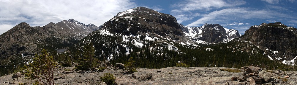
I arrived at the spur trail to Ouzel Lake at 10am. My earlier thought that 20 more years would erase much of the fire damage may be true lower down, but here it will likely be another century. It may be my feeble memory, but I’m thinking the aspen on the top of the ridge here have grown noticeably in the last year, but on the slopes above the trail there’s still nothing but grass and dead tree trunks after 34 years.

A few minutes later I passed through last year’s avalanche debris. If I hadn’t known it was there I wouldn’t have noticed it. There was “fresh” sawdust where a couple of tree trunks were cut to clear the trail, but that’s about it.

There was almost no snow left on the trail, only about a hundred yards of it to cross just below the outlet of the lake. From Ouzel Falls to the lake, I only met four other people on the trail, not bad for a weekend. Two guys passed me going up, headed to summit either Copeland or Isolation (they hadn’t decided) and two solo women on their way down from Bluebird. Both noted that it was quite windy at the lake.

I reached Bluebird Lake at 11:30 and stayed nearly an hour. I set up the GoPro for a time lapse. There wasn’t a cloud in the sky in any direction. I heard the occasional jetliner pass overhead but even those left no contrails. (So there’s nothing to see in the resulting time lapse video.) It was quite breezy, but that’s more or less to be expected. There was also a rich insect life in evidence – swarms of gnats and mosquitoes. I had the choice of sitting out of the wind in a swarm of insects or out of the insects in the wind. I chose the wind.
On the way out the trail was much busier. Between the lake and the Ouzel trail spur I passed maybe 20 people, and obviously the lower sections of the trail were quite busy with folks wearing flip flops and carrying little or no water.

I never saw any smoke from either the fire in Estes (which I didn’t learn about until later) or the High Park fire. And not a cloud in the sky all day.

I was to meet my brother for a beer at Oskar Blues in Lyons but my wife had called him to tell him about the fire on High Drive. Neither of them knew exactly where the fire was, but they’d heard the south entrance to the park was closed so he headed up there to look for me. I always tell my wife where I’m hiking, but I’ve never thought to tell her where I’m driving. So I had to sit and drink beer for a while before my brother arrived.

Ypsilon Lake

Before I started this blog I had been posting trip reports to a forum for lovers of Rocky Mountain National Park. This is one of those reports, with only minor edits for clarity.

Hike date: 30 May 2012 — Originally posted: 01 June 2012 – 01:00 PM

Looks like I won’t have a chance for any more weekday hikes for a few months, so I had to get one more in. I didn’t want to deal with Bear Lake road so I decided Ypsilon Lake was a good choice. I wasn’t sure how far I wanted to go – perhaps I’d head up to Chiquita Lake or scout the route to Spectacle Lakes.

There was no snow on the trail until about Chipmunk Lake. From there on, there wasn’t a lot of snow but what was there was rotten. Many times I stepped where it looked like it had supported many hikers before me only to posthole to mid-thigh. Not a big deal, but it made for a few surprises. The weather was pretty good, mostly sunny and not too cool or too warm but the wind was fairly annoying. Once to Ypsilon I sat for a while to do a time lapse. After that I headed to the inlet. Quite a bit more snow there so I decided not to go any further. Back at Chipmunk I did another time lapse.

Every time I try one of these I learn a little bit more. My last few hikes I’ve carried a small tripod. It gives a bit more flexibility on camera placement and keeps the camera from moving. As long as I make sure to anchor the tripod properly in the wind. The camera is automatic everything so I’m a bit stuck. I’ve noticed issues with the exposure before, but nothing too extreme. This time there are definitely some overexposed frames. I’m wondering it will work better if the camera is in the shade. In any event, I really don’t want to manually edit the exposure on dozens of pictures.

Anyway, here’s the end result:

Castle Lake

Before I started this blog I had been posting trip reports to a forum for lovers of Rocky Mountain National Park. This is one of those reports, with only minor edits for clarity.

Hike date: 15 October 2011 — Originally posted: 16 October 2011 – 09:18 PM

My latest hike was to Castle Lake. I went Saturday (10/15) and the weather was fabulous. To get to Castle Lake, the Foster guide says to go to Lion Lake #1 and contour around a prominent bench. I was thinking it should be pretty easy to get to Castle Lake by striking northeast from the trail, rather than going all the way to Lion Lake #1. Without GPS it’s not that simple. Although the lake is only 500-600 feet from the trail, there’s just no way to know where to leave the trail unless you’ve been there before. This is another lake I could easily imagine hasn’t been visited before. No trail, no cairns.

Castle Lake has no inlet streams and no outlet stream. At this time of year, the water level is quite low. It has also begun to ice over, even though it hasn’t been particularly cold yet. There is some snow on the ground – I first came across it on the trail at perhaps 10,000 feet. Seldom more than a few inches deep it didn’t cause any navigational issues. At the lake, I found a few “drifts” that were perhaps a foot deep. I didn’t see any large wildlife, but I did follow some deer tracks through the snow on my way back to the trail.

This time I carried a small GoPro HD video camera with me. Turns out it’s not a particularly good tool for landscape photography, as it has a very wide angle lens. The only useable footage was when I played with the time lapse feature while I was eating my lunch. Here’s 22 minutes compressed to 22 seconds:

This was only my second time up the Lion Lake trail. I really like this trail, at least the part from the Thunder Lake trail to Lion Lake. The forest isn’t dense, so you sometimes get glimpses of the surrounding mountains. Very pretty.

Chiquita Lake

Before I started this blog I had been posting trip reports to a forum for lovers of Rocky Mountain National Park. This is one of those reports, with only minor edits for clarity.

Hike date: 30 September 2011 — Originally posted: 01 October 2011 – 07:23 PM

Yesterday I hiked to Chiquita Lake. The weather was glorious – clear blue skies, not even a hint of afternoon showers. It was a bit breezy in the morning but mellowed out nicely before I got out of the trees. It was my first hike to Chiquita and my navigation was a bit off. After enjoying the falls just above Ypsilon’s inlet I managed to find a rock outcropping with the only view I got of Ypsilon Lake. I found a couple of log bridges over the stream but I stayed on the left side, or at least I thought I did. Before long I reached a pretty falls on the right side of the valley. In retrospect, I think this must be the stream from Spectacle Lakes, but at the time I thought I was well beyond where that stream should have been. By now I had climbed a fair bit from the valley floor, so I traversed the slope toward the top of the valley.

Only near Ypsilon did I find anything remotely resembling a trail. I didn’t see any cairns the whole way. But it was fairly easy hiking at this time of year. The ground cover had been knocked down (don’t know what kind of plants – I’m not a plant guy, but they’d probably have been waist deep had they not all been bent over).

I hit the trail a few minutes before 8am, was at Ypsilon by 10:30, and at Chiquita by 12:15. That last 8/10’s of a mile was a bit slow, but very enjoyable. It only took me an hour to get back to Ypsilon as I went a more direct route. The outlet of Chiquita was interesting – I couldn’t see the stream at all. It flows under a jumble of rocks for a few hundred yards. I could hear the water the whole time, but it wasn’t a visible stream until back in the trees.

Chiquita Lake

When I got back to Roaring River, I couldn’t help but notice the freakishly tall aspen trees there. These things must be 50′ tall, with no limbs until 30′ above ground. Here’s a vertical panorama (is that an oxymoron?) that doesn’t do them justice:

Tall Aspen

Bench Lake

Before I started this blog I had been posting trip reports to a forum for lovers of Rocky Mountain National Park. This is one of those reports, with only minor edits for clarity.

Hike date: 24 September 2011 — Originally posted: 28 September 2011 – 11:57 AM

Saturday I hiked the North Inlet Trail to Ptarmigan Creek, then off the trail to Bench Lake. Shortly after starting up the trail, I had a bit of discomfort on my right ankle. I have a couple of seasons of hiking in these boots and was a bit surprised that I’d be getting a hot spot there. Not a big deal, though, so I continued. It’s something like six and a half miles to Ptarmigan Creek, and the trail climbs very gently. In spite of my ankle I was making good time, something like 3 miles per hour. By the time I reached the creek I had only encountered 7 other hikers, 3 of whom started at Bear Lake.

I went up and down the trail a few yards either side of the creek looking for anything resembling a trail but didn’t see anything so I just headed up the hill. In the macro sense, navigation is trivial – just stay on the east side of the creek as you climb. It’s a fairly steep climb (for me at least), and I was more concerned with encountering terrain I would be unwilling to descend. I’m a bit of a fraidy-cat when it comes to steep descents, particularly when I’m hiking alone. My general rule is to never go up anything I need to use my hands on because I know I’ll get the heebie jeebies on the way down. Saturday, though, I broke my rule because I have hiked three times this summer where I didn’t make it to my destination and I was so close I didn’t want to turn around.

War Dance Falls are somewhere near the top of the climb. It’s a bit hard to tell where they are exactly, as the creek between the trail and the lake is basically a falls the whole way. I was unable to get a view I liked for a photo.

Bench Lake

I sat for about a half hour and had my picnic lunch before making my descent. I managed to go down pretty much the same way I went up. I was a bit surprised, as in the best places there is just a faint suggestion of a trail. When I got to the steepest bit, where on the way up I recognized I’d have problems, it’s steep enough that my fanny pack was in contact with the ground. I carry two water bottles, one on each side of my pack. At this point, one of the bottles got nudged out of its holder and bounced down the mountain towards the creek. I thought I saw it get lodged between a rock and a tree, but when I got closer I could see that I was mistaken. I lost my bottle. Murphy’s law applies here – I didn’t lose the half empty bottle but the full one. I’d have to ration my water a bit for the 7 mile hike back to the car.

When I got back on the trail my ankle really started bothering me. At one point, I thought I felt moisture there – I thought my blister had popped or torn open. Nothing for it but to continue as best I could. It was painful enough for me to alter my gait a bit. I tried taking longer strides or shorter strides, I tried walking slower and walking faster, but nothing helped. In the end, it really affected how fast I could hike and the same trail I was managing 3mph on the way up I was now doing less than 2mph down.

I made it back to the car with a few sips of water left. When I changed from my boots to my shoes, I expected to see a bit of a mess on my ankle. Much to my surprise, there was no blister. There was a bit of swelling but no redness. I’m guessing now that I got some sort of insect bite. It got red later in the day, and was puffy for another day or so. Now the swelling and redness are gone but I still have a bit of pain. Why couldn’t the damn insect have bitten me a couple inches higher?

Bench Lake is the 44th lake I’ve visited in the park. There are still a few more I can get to on my own, but they’re getting to be longer hikes and farther off the trails. I think I can probably do Nokoni and Nanita on this trail even though they’re quite long for day hikes. But the first seven miles of trail is so flat I think I’m willing to give it a try. Maybe next year.

Bench Lake verdict: It was nice to get there once, but probably not worth the effort a second time.


Igloo and Ice Tour

Sunday, March 18

It’s Stomp time again. This year, we had a choice: The Loch on Saturday or Lake Haiyaha on Sunday. I wavered back and forth for a while. I always enjoy a winter trip to Haiyaha but I’m generally up for a change of pace. But events conspired to ensure that I’d be doing Haiyaha again this year.

Ed wanted us to assemble at Bear Lake parking lot at 8:00am. So I set the alarm for 5:30, had the car packed and hit the road shortly after six. Entering Boulder I realized I forgot to bring my scarf. When I got to Lyons I realized I forgot to bring my hiking socks. I generally only manage to forget one item, so I was off my game already, and the sun hadn’t even come up yet.

I pulled into the parking lot on time. The car’s outside thermometer read 19°, but it was quite calm for a change. The weather forecast for Denver said we’d have rain turning to snow in the afternoon, but there’s always a potential for interesting weather along the divide so I wasn’t too concerned.

Ed was already there, with Brooke and Tony. We made our introductions, got kitted up, and hit the trail. It really was a beautiful morning. The sun was shining brightly, the skies were a clear blue, and there was no wind at all. It doesn’t get much better than this.

Brooke, Ed, and Tony

Our first stop was an igloo Ed built for a fundraiser. It was quite a bit closer to the trailhead than he usually builds. The door was quite small; there wasn’t a lot of depth to the snow here. He did the best he could given the conditions. Ed is always a wealth of interesting information. Today one of the topics had to do with some of the details of igloo building at the microscopic level. Specifically: sintering. I was familiar with the term, but not in this context. My brake pads are sintered metal. In igloos, when the snow is compressed, the crystal arms are broken and then the rounded grains fuse into larger crystals.

This is the third or fourth time Ed has guided me to Haiyaha in the winter. Each time, he’s attempted to give me enough information that I could follow the route myself. I’m pretty sure I still can’t get there on my own. I’ve always considered myself pretty good with route finding and paying attention to my surroundings, so I don’t know why I have so much trouble. Oh well.

Haiyaha panorama

I brought the SLR with me this trip and left the GoPro at home. I’d concentrate on trying to get pictures of the always interesting ice at Haiyaha. But the first thing I did was sit down to eat my picnic lunch and by the time I was done, the sunshine was gone as the storm clouds coalesced overhead. Ed said he sometimes has better luck without sunshine . I don’t think it matters much for me. The ice always fascinates me here, but I can never get a photo that is anything like a true representation.

Blue ice slab

Lake Haiyaha has a leak. It lies in a big pile of boulders at the foot of Chaos Canyon. Most lakes in the area are a foot or a foot and a half lower in winter than in summer. Last time I was here, I speculated that for Haiyaha it’s more like six or eight feet. Ed suggested it could be fourteen feet. It may not be that much, but I’d guess that today the top of the ice is at least ten feet below the high water mark on the rocks.

Ice detail

Around the edges, the ice is suspended by the rocks. Walking on it, you can hear that there’s a chamber beneath your feet. There are places where slabs of ice a foot and a half thick are exposed and you can see underneath them. The ice has a light blue color and there are columns of bubbles frozen inside. In other places, the surface of the ice isn’t flat as you’d expect, but looks the lake was frozen in an instant, all the ripples and waves preserved.

Rippled ice

Ed knew of another igloo up on the ridge between Dream Lake and Haiyaha so we headed up to check it out. Before we got off Haiyaha’s ice, we met the two guys who spent last night there. Ed knew them, of course. Ed doesn’t just know every tree and rock in this area of the park, he seems to know all the people, too.

Ridgetop panorama – Haiyaha

This igloo was pretty much right on the top of the ridge, a low arm of Hallett Peak. Below us to the north was Dream Lake. Just a few yards away there was a nice view of Haiyaha to the south. It really is a spectacular place to spend some time. My pictures don’t do it justice.

Ridgetop panorama – Dream Lake (bottom left)

From here we descended to Dream Lake. “Whoa, Ed, where are you taking us? You know I don’t like steep descents!” I had mentioned this to Ed on a previous hike, but he hikes with so many people it’s a bit much for me to expect he’d remember my reluctance. But I felt I was in good hands and didn’t complain too much (I hope!) about being pushed a bit out of my comfort zone. I don’t think I slowed the group down too much and before long we were done with the steep bits. I went down a few places on my keister, only getting a bunch of snow down my backside once.

From there, we followed the summer route back to Nymph so we’d be on the north side of the lake. That’s where the winter shortcut to Bear Lake is. I’d been up that way from Bear once before but never went back this way. It’s a bit shorter, a bit steeper, and a lot less crowded.

We were back to the parking lot by about 1:30. We reckon we covered only about four miles. A light snow started to fall by the time we hit Nymph, and back at the parking lot it was starting to get heavy. But by the time we exited the park the snow was behind us.

All in all, a quite enjoyable hike: an interesting route and good company.

Junco Lake

Sunday, September 3

Leading up to this hike, I was telling myself that I only need to visit two more lakes in Wild Basin and I’ll have been to them all. I was thinking I only needed to go to Junco Lake and Isolation Lake and I’d “have the set.” I was a bit off. In addition to those two, I also have yet to hike to Frigid Lake and Indigo Pond. In any event, my goal for this next hike was to get to Junco Lake.

Originally, Chad was going to go with me but his plans changed. We were going to meet Bob at the trailhead. Bob wouldn’t go with us, but would accompany us the first few miles. But I didn’t properly communicate where Bob was to us me and we didn’t connect. I waited a few minutes past our appointed rendezvous for him then hit the trail. I discovered later that he was there, just at the wrong trailhead. Entirely my fault.

Anyway, to get to Junco Lake we will essentially start with Bluebird Lake. The hike to Bluebird Lake has a lot to offer. It has three notable water features: Copeland Falls, Calypso Cascades, and Ouzel Falls. Then there are the open views where the trail goes along the top of a ridge that was burned by the Ouzel fire back in ’78. And the last three times I’ve hiked to Bluebird, other hikers have said they’ve spotted moose. I never can find them, but that’s just my luck.

Just above Ouzel Lake the trail passes through some talus and with no trees there, it’s an ideal place for raspberries. There are a number of stretches where raspberries grow in abundance. I couldn’t resist tasting a few. The berries may have been small, but they were delicious. The leaves were starting to turn dark, and there were no immature berries. The plants are much smaller than the ones in my back yard. But the weight of fruit as a percentage of the total weight of the plant is much higher. These little plants were densely covered with the sweet little tasty morsels.

A little farther up the trail I came across a couple who had passed me on the trail a bit earlier. Looked like they were picking berries, but there were no raspberries here. “We found huckleberries!” I’m sure I’ve had a slice of huckleberry pie, but I could certainly never identify them in the wild. These were growing on very small plants, close to the ground. Most of the berries were red, about as red as a not-quite-ripe raspberry. “You want the purple ones.” They were quite tiny, not much bigger than a BB but quite tasty.

The steepest part of the trail below Bluebird Lake is also quite lovely. The hillside is covered with an avalanche of wildflowers. I was thinking it might be a bit late in the season, but here the flowers were still quite vibrant.

I was pleased with my progress thus far, reaching Bluebird in a few minutes over three hours. It’s less than a mile from Bluebird to Junco, but there’s no trail and about a 750′ climb.

The Foster guide says to go around the base of the ridge and follow the stream. The last few times I went to Bluebird I spent some time studying the terrain and was never happy that that was the way to go. So I asked around. Kristin sent me a couple of pictures with two suggested routes. Each looked to be better than Foster’s suggestion.

So, without taking a break here, I headed up the ridge to Junco. It was easy enough to start, there are all sorts of grassy ramps and shallow gullies. But before long I managed to get to a spot that I didn’t like and backtracked a little. Then I ran into the couple I shared huckleberries with. I followed them for a bit, until they went down a section that made me uncomfortable. I let them go their way; I headed to the top of the ridge. Kristin told me it would be easier up top and I think she was correct.

I made it to Junco pretty much at the same time as the Huckleberries. I made my way to a comfy spot near the outlet and tucked in to my picnic. The wasn’t a cloud in the sky, but there was a faint haze from wildfires half a continent away. I brought the GoPro with me but didn’t bother setting it up as, without clouds, there’s no point in trying to do a time lapse video. Meanwhile, the Huckleberries had changed into their swim suits. She did a bit of sunbathing but he took a dip in the lake. I put my soda can in the water for a few minutes so I’d have a cold drink.

Ouzel Peak and Junco Lake

I headed back down after a half hour break. Having told myself that I’d be better off staying on the top of the ridge, I found myself heading down one of the many grassy ramps. It started off well enough but soon had me in a spot I didn’t like at all. I backtracked and chose another ramp. Again, no joy. As I was backtracking the second time, I ran into the Huckleberries again. I followed them for a good while, but they were moving faster than me and soon were out of sight. But by then I was pretty sure we were retracing the route we used on the way up.

Mahana Peak, Bluebird Lake. Longs and Meeker in background.

I took another break at Bluebird – snacked on my peach and slathered on another coat of SPF. At the Upper Ouzel campsite the trail crosses the outlet from Bluebird. I refilled my water here. By the time I was back to the car, I’d used up all the water. That’s the flip side of the open views in the burn area – there’s no shade and I feel a little broiled in the afternoon sun. I drank as much water in the last five and a half miles as I did in the first nine.

It was a full day, and by the time I made it back to the car I was exhausted. The Foster guide tells me it’s 7.2 miles from the trailhead to Junco Lake, with a 3,210′ net elevation gain. I’m guessing that with my backtracking I didn’t add much distance but did add a non-trivial amount of elevation. The hike was not only physically challenging, but I’ll admit to more than the usual difficulty route finding.

Timetable

Out In
Trailhead 07:30 AM 05:04 PM
Calypso Cascades 08:12 AM 04:19 PM
Ouzel Falls 08:31 AM 03:56 PM
Thunder/Ouzel junction 08:41 AM 03:45 PM
Ouzel/Bluebird junction 09:20 AM 03:08 AM
Bluebird Lake 10:42 AM 02:00 PM
Junco Lake 11:55 AM 12:30 PM

Snow Lake

I’ve been wanting to do this hike for a few weeks. Although the hike neither starts nor ends inside the park, it’s in Foster’s guide. And we did make a short side trip to walk a few paces inside the park, so it goes on my list of RMNP lakes.

Saturday, July 15

The trailhead for this hike is up a dirt road a few miles on the west side of Cameron Pass. Google tells me it’s two and three-quarter hours from my house. It’s a fairly short hike, 3.9 miles to Snow Lake, so we didn’t have to leave too early. Not knowing what condition that dirt road is in, I arranged with Genae to take her car. But when Chad got here, he volunteered to drive. We hit the road in his Pilot at 6:30.

The hike is in the Colorado State Forest State Park. Yes, two “states”. It’s a fee area. There’s a box after we turned off the highway with a place for envelopes and a drop slot. You put your money in the envelope, take the carbon copy and deposit the envelope in the slot. But there were no envelopes, other than one that wouldn’t fit through the slot because it was full of quarters. So I Just chucked the money in the slot.

When we got to the parking lot we find another box, this one with a good supply of envelopes. I put the carbon in the window, scribbled “put cash in other box” on the envelope and put it in the slot.

The trail looks like it used to be an access road to the Michigan Ditch. It clearly hasn’t been used as such for quite a while, but it probably could still serve that need if required. I haven’t researched it, but I assume the Michigan Ditch is roughly the same vintage as the Grand Ditch a few miles south. The Michigan Ditch diverts water from the Agnes Lake drainage to the Cache le Poudre River.

We can assume the former access road the trail follows was built to provide access for the construction of the ditch. This would be roughly a century ago. I can’t help but wonder how big an operation it was. What sort of equipment did they have? How many men doing earthwork and how many more to support them in this remote area? How long did it take to build these ditches?

I’ve been to Grand Ditch twice. It was dry both times. Michigan Ditch was carrying quite a bit of water today; clear, clean, cold. Above the ditch, no longer an access road, the trail narrows and switches back a few times as it climbs. There are abundant open views of the surrounding mountains: all rounded and smooth, with no cliffs and very few rock outcroppings. The Rocky Mountains aren’t so rocky here.

There were a good number of vehicles at the trailhead, and a corresponding number of people on the trail. Being a state park, dogs are allowed, and the majority of hikers had dogs with them. When we arrived at lower Michigan lake, we met three hikers with a dog. They were sitting on the stone blocks that make the trail, stepping stones across the outlet instead of a bridge. They got up to let us pass, but the dog growled and barked at us, protecting the bridge from us.

Lower Michigan Lake

My map indicates the trail to Snow lake goes to the left, where it junctions with the trail to Thunder Pass and into the Park. So that’s where we went. We soon encountered a hiker who told us there is no junction, this trail goes over Thunder Pass. The map is old; today the trail to Snow Lake is on the other side of the lower lake.

Looking north from Thunder Pass

Knowing now that we’re on the trail to Thunder Pass, we make it a side trip. We cross a shallow trickle of a stream and about forty yards of snow. Signs at the top of the pass demarcate the Park boundary. The view to the south is quite nice, if unspectacular. With our backs to Michigan Lakes, all the mountains in sight are rounded tundra. The lower hairpins of Trail Ridge Road are visible in the middle distance. Longs Peak is not visible.

Rather than backtracking to the outlet of the lower lake for the trail to Snow Lake, we head cross country on a route that will take us gently up the slope to the top of the bench that holds the lake. I thought it was a pretty easy climb. I paused at one point to get my bearings and take in the view when I heard a noise at my feet. It’s typical to find marmots in these jumbles of rock. Usually they bark or chirp to sound the alarm then scamper under a rock. This guy came out onto the rock at my feet and posed for us.

We had to cross the outlet stream, but that wasn’t a problem. The water was mostly running underneath the rocks. Where it was on the surface, it was easily stepped across. There was no krummholz to deal with. The only willow in the area was only inches tall. Wildflowers were varied and abundant, but not particularly dense.

Just before cresting the bench we came across the trail from the lakes below. Here we found columbines covering the ground in front of us. There was a patch of white columbines. I’d heard of white ones, but had never seen any.

From there, it was just a few hundred feet to the lake. The lake sits in a rocky bowl, some snow still draping the rocks on the southern shore. The rocks on this side were two to six feet across, with many that might make nice picnic spots. We worked our way a short distance from the top of the trail where the other hikers tended to congregate.

We stayed at the lake for about an hour. Chad spotted a marmot maybe a hundred yards down the shore. The marmot soon started on his way toward us. He made pretty good time. He was on a mission. It wasn’t until he got fairly close before he worried about staying out of sight.

Two hikers arrived at the lake a minute before us and four or five came and left while we were there, the last leaving just a few minutes before us. We followed the trail down to the lower lake. Or, tried to, anyway. We lost the trail coming down the steep slope. This was pretty much straight up and down the slope; I much preferred the way we went up. I think we lost the trail after wading through waist deep willow. Approaching upper Michigan lake, we cross a talus field. Here, it turns out, the trail splits to a high road and a low road. We took the high road, not really noticing. We were on a trail that went along the top of a ridge line; the other path went beside the lake shore.

Below the lakes we came across three women standing on the trail. They’d spotted a cow moose. We paused briefly and when we continued slowly down the trail the moose was working her way parallel to us a ways off the trail. When we got a bit ahead of her she bolted the opposite way. The three women were behind us, one asking “Was that a moose?”

Back near the ditch we encountered some bicyclists. They had been riding the service road beside the ditch and evidently decided to take a little side trip. Their gear and clothing all looked brand new and they seemed out of place to me. I suspect they didn’t get far up the trail before turning around. I suspect they were much more comfortable along the ditch.

We were back to Ft. Collins by five, where we tracked down first some beers, then tacos. It was a most pleasant day.

Lake Haiyaha

Saturday, July 1

It has been a while since I visited Lake Haiyaha in the summer. I have been there many times, and the last three or four visits were in winter. For me, winter and summer trips to are so different that they may as well not have been the same place.

In winter, I follow a route that I’ve proven I’m unable to find on my own. I’ve successfully navigated to ninety lakes in the park, and I’ve spent a lot of time around Bear Lake. It doesn’t bother me that I haven’t been able to get there without a guide. On the contrary, it makes a common hike unusual. On these winter Haiyaha hikes we don’t encounter many other hikers, which is unusual for so close to Bear Lake.

And, of course, in winter the landscape is totally different. Some gullies get filled in, some drifts are twenty feet deep. You take different routes. In winter, at Haiyaha, the water level drops so much, massive shards of ice make volcano shapes around large no-longer-submerged boulders. So although I’ve been there four or five times in the last ten years, it’s been maybe ten years since I’ve been there in summer. It is time to face the crowds and go in summer.

It’s a short hike, so I didn’t need to be early. I’d park at the park and ride and shuttle to Bear Lake. The line for the bus was the longest I’ve ever seen it, but the wait wasn’t too bad. I was on the trail by 9:15. The route I always take is Bear Lake to Nymph and Dream, then to Haiyaha. The return is down to the Loch Vale trail junction, then either the Fire Trail or by Alberta Falls to the Glacier Gorge bus stop.

Between Bear Lake and the trail junction at Dream Lake, a distance of 1.1 miles, I passed over a hundred people. This is people were standing or sitting trailside or hiking in my direction. Not many people going the other way. Conga-line hiking.

From Dream to the bridge over the outlet of Haiyaha it was much better. I could still hear the voices of people on the trail below. My original plan was to go above Haiyaha a little way up Chaos Canyon. Michael and I did that last time we came here. You get a nice view of the lake, but eastern views are not the most dramatic here. With that in mind, I came across a family sitting on a log, taking selfies. They were right next to a fairly obvious trail, which I followed.

The trail petered out after a while, but I easily traversed a small ridge and made my way to the northern shore of Lake Haiyaha. I’d never been on this side before. The trail dumps you into a large pile of boulders. There’s no shore. Here there are many places one could dip their feet into the water, and there is shade, if you want it. I worked my way a bit farther to the west and found a nice spot with a view of Long’s Peak, a much more interesting horizon than up the canyon above the lake. And, best of all, no neighbors.

Spiders construct substantial webs between the boulders. Sometimes they can be hard to spot. One day, traversing a large talus field, the light was just right. I could spot them from several feet away, and see the spider scramble from the center to safety on the rock as I approached. To say that Lake Haiyaha features a rich insect life might be to understate it. Here, today, the spider webs were easy to spot – they all had dozens of captured insects.

I found a nice spot to relax, a seat in the shade and three feet away a seat in the sun with the flank of Otis Peak front and center, the top of the canyon to the right, capped with heavy cornices of snow, and the erect nipple of Long’s Peak to the left. There was a cloud of gnats not far to my left, but they stayed where they were and didn’t annoy me. The occasional horse fly or curious bee made a visit, but no mosquitoes.

I brought both GoPros with me and the cell phone but not the SLR. I tried to get a picture of the laden spider webs but the cell phone isn’t up to it. I was game to get some nice time lapse footage but there wasn’t a cloud in the sky. Pretty blue skies, but just a shade on the hazy side due to wildfires in Utah. But it was clearly particulate matter and not water – passing jetliners’ contrails spanned fingers only a few inches apart, held at arms length.

I reached my spot at 10:10. I didn’t have any other plans for the day, so in theory I could sit here for something like four hours and still get home by 5:00. Surely in the next hour or hour and a half, some clouds would start bubbling up along the divide.

There was nobody on my side of the lake, but twenty or thirty at any given time on the other side. When the wind was calm, or a light breeze blew across the lake to me, I could hear snippets of their conversations. They were a chatty bunch.

At 11:30 I saw a tiny wisp of cloud above Half Mountain so I started up one of the cameras. This little wisp struggled only a short while, lived only a few minutes. I let the camera run, in case it might make a comeback. Alas, it was the only cloud I saw until I was off the trail at 1:45.

Shortly after noon I decided it was time to pack up. Nothing was happening in the sky. Normally, I sit at a lake for thirty minutes to an hour. I’d been here two hours and enjoyed every minute of it. But now I was hearing voices on my side of the lake, somewhere to my east.

On the way to the trail I found the people I’d heard a few minutes before. I surprised them when I greeted them on my way out. As usual, I headed out the back way toward the Loch Vale trail junction. I wasn’t sure yet whether I’d go by Alberta Falls or take the shortcut. I had this section of trail, from the lake to the junction, all to myself. My solitude ended as soon as I hit the main trail again. Any doubt I had as to my way back evaporated like that tiny wisp of cloud. I’d take the shortcut and avoid the hundreds of people on the trail.

I’m happy that I can hike to a place I’ve been to many times before and still get some pleasure out of it. I’m reluctant to take these shorter hikes in summer because of the crowds. Today was probably one of the busiest days of the year. On my way out of the park, the line of cars at the entrance station stretched to just a few yards short of the Beaver Meadows visitor center. Cars were parked illegally along long stretches of Bear Lake Road, and all the parking lots and pullouts were full. And yet, I was able to find a few yards of quiet trail in the busiest part of the park.

Just another beautiful day in the park.

Bluebird Lake, Almost

Sometime last year my Eagle/Box trip got a few dozen hits in just a couple of days from a MeetUp group, the Grey Wolves. So I joined. I figured if there was a group that went to Eagle Lake, they’d likely go somewhere new for me.

Sunday, June 18

The original plan was that Chad and I would head to American/Michigan Lakes near Cameron Pass. His plans changed. Then I saw an invite from the Grey Wolves for a Bluebird Lake hike. Bluebird Lake isn’t new for me, but could make for a good test drive for joining the group. I’ve been there a couple of times, and will need to go again to collect my last two Wild Basin lakes: Junco and Isolation.

The first time I tried to get to Bluebird was in mid-June of a snowy year. I didn’t make it much past Ouzel. I walked into an avalanche debris field. The avalanche could have happened two days before or two weeks before, I had no idea. The snow was like a giant pine sno-cone. Trees were reduced to their elements – tree trunks, snapped like toothpicks, with no limbs and all the bark stripped off. Branches and twigs of all sizes. All mixed up. The entire forest smelled like a lumber mill. Water coursed down the slope, everywhere, audible under the mass of snow and rubble. It was almost alive. Over the course of eating my picnic, the debris pile visibly settled.

A once in a lifetime experience, no doubt.

Prior to the debris field hike, I attempted Ouzel in mid-June. That time, the section from the Thunder Lake/Ouzel Lake trail junction to the top of the ridge was snow, and the entire meadow below Ouzel was a complex of drifts. So I had a pretty good idea we’d have to hike four or five miles of snow, given the heavy late spring snows this year. Anyway, Bluebird sounded like a nice hike for a June day.

We met at Lyons and carpooled to the trailhead. Got there just in time, as we got the last few parking spaces. We were on the trail at 8. We maintained a nice pace on the trail, although we stopped more than I generally stop. We went through the little bypass for Copeland Falls, which I normally skip. But that’s okay, it’s a pleasant day. The water was running very high. Not the highest I’ve ever seen it, but close.

The lower part of the hike follows the river closely. The sheer volume of water demands attention. It roars. The amount of water was truly remarkable. We leave the river for a while when we cross it at Ouzel Falls. This is the first time I’ve been here since the 2013 floods. The bridge was out for a long time. I’m not sure when it got reopened, but it’s open now. They moved it a few yards downstream. And based on how high the old bridge was, I tried to visualize how high the water had to be to carry it off.

The new bridge is obscured by trees. The old bridge was sited to the left of the tree stump and the trail ran on this side of the log on the right.

We didn’t get to snow until we arrived in the area of my avalanche debris field. Somehow I was in the lead after we all deployed our micro spikes. Shortly thereafter, we arrived at a large rock outcropping. Water was cascading off it. Waterfalls everywhere. The sound of water was ubiquitous, torrents flowing beneath the banks of snow. Watch where you step in the low spots – snow melts from the bottom, often making delicate bridges.

In a few short weeks this area will be a riot of blue and yellow and red and white wildflowers. There are only yellow ones now, though, in bloom inches away from the snowbanks.

Leaving the outcropping we climb a gully to a large talus field. I’d forgotten about it and was thinking we were already approaching the lake. We had one more gully to climb. This final one is narrower and steeper. There is snow in it even into August. Today it’s a wall of snow maybe sixty feet high. I’ve been to the lake before, so I didn’t feel compelled to climb up it.

A few went up, but most of us had our picnics here. The narrow, steep gully on the right leads to Bluebird. The broader, shallow gully to the left leads to Junco. It’s still not clear to me the best route to Junco and this view of the terrain wasn’t terribly helpful, as it all looks so different with the snow.

After lunch we split up. Larry stayed at our picnic spot to wait for those who went all the way. I was in the early group to head back. Around Ouzel I kept my eyes peeled for moose. On the way up, hikers coming the other way reported moose nearby, but I don’t think any of us saw them. I was thinking there’s be a good chance they were still in the neighborhood. I didn’t spot them, but some of the others did.

I had both GoPros with me, but didn’t bother setting them up. There wasn’t a cloud in the sky until after 3pm. There weren’t even any jetliner contrails. The sun was brilliant but even on the exposed ridge wasn’t harsh, as it was still a cool, spring day.

I thoroughly enjoyed the day. I don’t normally do the same trail twice in a season, but I’m thinking I should try to get to Junco this summer. I’m thinking that the talus field below Bluebird Lake might be a good place to leave the trail and look for a route to Junco.