Dawn Patrol

Friday, August 2

My alarm went off at 2:45am this morning. Crazy, yes?

Kristin and Coop are in the neighborhood with plans to do a week’s worth of back country hiking. I’ve known them online for about a decade, and met them a year or two back. They’re nice people and we share a common passion so I reached out to them to see if we could get together to break bread or something. They suggested a few alternatives. Two of them don’t fit my schedule, and the third was to meet at the Bear Lake parking lot at 5am for a hike up to Dream Lake to watch the sunrise.

To get to Bear Lake at 5am, I need to leave the house not long after 3. This sounds like a stupid thing do, so of course I said “yes”.

The reason behind this is that Coop is a much better photographer than I am. My photos tend to be more like documentary evidence that I’ve been somewhere, while his you could call “art”. There’s a fundamental difference in how we go about it. That’s probably not correct: there are perhaps several fundamental differences in how we go about it. One of those is that he wants to take pictures during the “golden hour”. That means being somewhere at sunrise or sunset.

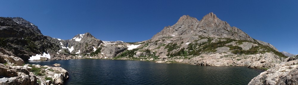
Which, today, means getting my butt out of bed before 3 and driving a couple of hours, then hiking a mile in the dark, all so we could be at Dream Lake for sunrise; to see Dream Lake and Hallett Peak bathed in the colors of the rising sun.

It seems I’m always saying I got out of the house a few minutes later than I’d wanted, and that I arrived at the trailhead late. But today I managed to leave by my desired time, and as might be expected, I hit no traffic once out of the city. So instead of being late I was at the Bear Lake parking lot early. I could have slept another fifteen minutes!

We hit the trail at 5. First decision was whether to take the shortcut to Nymph Lake or not. We went for the shortcut, but none of us could find it in the dark, so the long/usual way it was. Once at Dream, Coop picked a spot near the outlet. Another photographer was already set up there, and space was at a premium, so rather than get a poorer quality shot of the same thing as the others, I went for a slightly different angle and found a spot on a rock outcropping that wasn’t in their view.

The GoPro is fully automatic but I set it running anyway. I figured it would have a hard time with the lighting conditions, but you never know how things will turn out.

I’m really not a very astute photographer, and I still haven’t figured out all the ins and outs of the new camera. (I figured since it was another Canon it would be fairly similar to my old one. It is, but it isn’t. Most of the features that are in common work the same way, but not all. And there are loads of new features.) So I made some guesses and tried a few different things hoping that maybe I’d get a result I like. In the end, I think I did okay.

After watching the sunrise and taking in Dream Lake and Hallett Peak in all their glory we headed up to Emerald Lake. Kristin wanted to go there because it’s been a long time since she was there in summer. Hiking up there, it became obvious to me that I haven’t been there in summer in a long, long time myself. There are some wood bridges we crossed that I don’t recall ever crossing. I’m pretty sure every time I’ve been there in the last thirty years involved hiking across snow most of the way between Dream and Emerald.

We were up there early enough that it wasn’t crowded yet. We weren’t alone, but there were far fewer than the fifty or so (minimum, even in winter) that I’m accustomed to. I set up the GoPro again and we hung out there for quite a while. Hikers came and went the whole time, but the biggest group we saw was a mama duck with her eight ducklings. They swam around and stumbled over some deadwood floating on the edge of the lake before getting onto the trail like they were going to hike back to Dream Lake.

When we got back to the Bear Lake parking lot we discussed where we should go for breakfast and headed back to Estes Park. We ate at Molly B’s, sitting at the tables outside. It was quite pleasant (another beautiful day in the neighborhood), in spite of the heavy truck traffic rumbling up and down Moraine Avenue.

They explained where they were going to be hiking. It sounds like a nice time. I don’t know that I’m up to spending a week in the back country, but four years ago I’d have said I wasn’t up to any backpacking at all, so perhaps my attitude will change.

I like to think that I know my way around the Park. I may not know the names of all the mountains, even the ones I’ve hiked beneath many times, but I’d like to think if you mention a lake I’ll know where it is. So when Kristin talked about Ten Lake Park, I nodded as if I knew exactly what she was talking about. I had no clue. So after getting home, I had to look it up in the Foster guide. This will certainly go on the to-do list, most easily accomplished by staying a couple of nights near Verna Lake and getting there by bushwhacking up and over the flank of Mount Craig. It’s certainly too much effort for me to do as a day hike.

So it was a short day: too early of a start for me to make a habit of watching the sunrise, but a pleasant walk in beautiful surroundings, with friendly people. If they want to put up with me again, I’d be happy to meet up with them again on their next trip.

40° 18′ 25″ N, 109° 39′ 37″ W, or Thereabouts

Things have been a bit on the slow side at work lately. With summer hiking season winding down, I figured I could pick a day with a favorable weather forecast to take some PTO and hit the trails. The weather wonks in the Denver area have been missing their forecasts lately, predicting warmer weather than we’ve actually been getting, so this added a bit of variability. They told me Wednesday would be the warmest day for the foreseeable future so Tuesday afternoon I asked for Wednesday off.

Wednesday, October 3

I planned on a rather short hike, which meant I didn’t need to leave the house before sunrise. But a later start also meant I’d be facing morning rush hour traffic. As I work from home I almost never have to deal with traffic, so getting out in it once in a while is a good reminder as to how spoiled I am.

The Chrysler is getting old, and it sitting outside isn’t helping much. She’s getting senile. I can’t use the automatic headlights because every now and then they start flashing randomly. And the intermittent wiper often gives two or three wipes at a time. And so, when I saw the outside temperature reading at 73° on the approach to Estes I figured that was wrong, but the thermometer doesn’t yet seem to be demented. It did cool back down dramatically as I got closer to the Park.

On the way through town I spotted what I thought of as a clear-sky rainbow. I know that you don’t get rainbows without rain, but this one looked to be situated well away from any clouds. It was clear above, and the only clouds in sight were draped across the Continental Divide. Well, “socked in” more adequately describes it. Nothing above about 11,000′ was visible.

I was a bit surprised by how many people were in the park, given that it’s a weekday. The Bear Lake parking lot wasn’t yet full (but it was full when I left a bit after 1:00pm). This time of year I expect mostly locals, but there were still quite a few cars with Illinois, Minnesota, Texas, and California plates.

When I got out of the car it wasn’t particularly chilly, but it was (surprise, surprise!) fairly windy. By now I treat “windy” as the default state of things along the Divide, unless it’s mid-Summer, and sometimes even then. I wasn’t going very far, and I wasn’t exactly going to visit a lake; my intention was to spend my time surrounded by trees, so I didn’t let the wind bother me. But I didn’t put too much thought into exactly where those trees would be. My destination was the ridge that separates Dream Lake from Lake Haiyaha.

I took the shortcut from Bear Lake to Nymph Lake not so much to shorten the walk as to avoid the crowds. Rather than hustle up the Haiyaha trail, I followed the trail the few yards to the shore of Dream Lake. The clouds were impenetrable over the divide but the fierce winds that carried them east also tore them apart. To the east the skies were clear, and in the zone in between, the sun was able to play “now you see me, now you don’t” with the lakes. A few minutes patience allowed me a view of a sunny Dream Lake with clouds above.

After another quick pause to take in the views to the east, I left the trail before crossing Haiyaha’s outlet stream. There’s a bit of a trail here that gets used by the rock climbers that lasts until you reach talus. Once in the rocks I started heading uphill. It’s not too steep and there isn’t much to hinder progress – little deadfall and no rock outcroppings – and found myself at the top of the ridge in no time.

I sat up there for about an hour, letting the cameras run. I tried to stay out of the wind, but here at 10,472′ (according to GPS) it was a challenge. I found a place that wasn’t too bad. I kept an eye on the lake. For the last year or a bit more it has a distinctly glacial color to it. There was a slide a while back up the canyon and the snowmelt that passes over and through the slide has carried some sediment to the lake that gives it a turquoise color when viewed from above in sunlight. But every time the sun illuminated the lake it was over before I could capture that nice color. That just gives me an excuse to revisit this spot next summer, even though the color is already fading.

I made it back to the car pretty early so I decided to make a stop at Sprague Lake. I can’t help but notice that it hasn’t been on my list of lakes I’ve visited. Thinking about that oversight it occurs to me that I certainly haven’t been there in at least thirty years. That makes me wonder if I’ve ever actually been there. I’ve got to believe we were there as a family when I was a kid. Right? How can I have spent so much time in the Park, driven by the place hundreds of times, and never been there?

I took my time at Sprague. I let the camera run again for another half hour or so. The wind was not any less here than on the ridge above Haiyaha, particularly on the windward side. I was surprised the wind didn’t jostle my camera, as it was enough to kick up spray from the lake’s surface and unbalance the unwary pedestrian. The clouds were no longer obscuring the peaks but it wasn’t clearing up. If anything, they looked more threatening. Until you turned around and faced east, where it remained sunny.

The weather forecast turned out to be spot on. At roughly 3:30 I was mired in Boulder’s afternoon rush hour in balmy 83° sunshine.

I was hoping for better results on the time lapse. The Sprague Lake portion came out fine, with the possible exception of some spray hitting the lens. But the ridgetop sections don’t show any of the details of the clouds. The GoPro is just too wide-angle, and with the auto exposure it doesn’t handle changing light well at all. I haven’t been using the SLR since the cheap little tripod I was using broke. I guess I need to find a new tripod.

Igloo and Ice Tour

Sunday, March 18

It’s Stomp time again. This year, we had a choice: The Loch on Saturday or Lake Haiyaha on Sunday. I wavered back and forth for a while. I always enjoy a winter trip to Haiyaha but I’m generally up for a change of pace. But events conspired to ensure that I’d be doing Haiyaha again this year.

Ed wanted us to assemble at Bear Lake parking lot at 8:00am. So I set the alarm for 5:30, had the car packed and hit the road shortly after six. Entering Boulder I realized I forgot to bring my scarf. When I got to Lyons I realized I forgot to bring my hiking socks. I generally only manage to forget one item, so I was off my game already, and the sun hadn’t even come up yet.

I pulled into the parking lot on time. The car’s outside thermometer read 19°, but it was quite calm for a change. The weather forecast for Denver said we’d have rain turning to snow in the afternoon, but there’s always a potential for interesting weather along the divide so I wasn’t too concerned.

Ed was already there, with Brooke and Tony. We made our introductions, got kitted up, and hit the trail. It really was a beautiful morning. The sun was shining brightly, the skies were a clear blue, and there was no wind at all. It doesn’t get much better than this.

Brooke, Ed, and Tony

Our first stop was an igloo Ed built for a fundraiser. It was quite a bit closer to the trailhead than he usually builds. The door was quite small; there wasn’t a lot of depth to the snow here. He did the best he could given the conditions. Ed is always a wealth of interesting information. Today one of the topics had to do with some of the details of igloo building at the microscopic level. Specifically: sintering. I was familiar with the term, but not in this context. My brake pads are sintered metal. In igloos, when the snow is compressed, the crystal arms are broken and then the rounded grains fuse into larger crystals.

This is the third or fourth time Ed has guided me to Haiyaha in the winter. Each time, he’s attempted to give me enough information that I could follow the route myself. I’m pretty sure I still can’t get there on my own. I’ve always considered myself pretty good with route finding and paying attention to my surroundings, so I don’t know why I have so much trouble. Oh well.

Haiyaha panorama

I brought the SLR with me this trip and left the GoPro at home. I’d concentrate on trying to get pictures of the always interesting ice at Haiyaha. But the first thing I did was sit down to eat my picnic lunch and by the time I was done, the sunshine was gone as the storm clouds coalesced overhead. Ed said he sometimes has better luck without sunshine . I don’t think it matters much for me. The ice always fascinates me here, but I can never get a photo that is anything like a true representation.

Blue ice slab

Lake Haiyaha has a leak. It lies in a big pile of boulders at the foot of Chaos Canyon. Most lakes in the area are a foot or a foot and a half lower in winter than in summer. Last time I was here, I speculated that for Haiyaha it’s more like six or eight feet. Ed suggested it could be fourteen feet. It may not be that much, but I’d guess that today the top of the ice is at least ten feet below the high water mark on the rocks.

Ice detail

Around the edges, the ice is suspended by the rocks. Walking on it, you can hear that there’s a chamber beneath your feet. There are places where slabs of ice a foot and a half thick are exposed and you can see underneath them. The ice has a light blue color and there are columns of bubbles frozen inside. In other places, the surface of the ice isn’t flat as you’d expect, but looks the lake was frozen in an instant, all the ripples and waves preserved.

Rippled ice

Ed knew of another igloo up on the ridge between Dream Lake and Haiyaha so we headed up to check it out. Before we got off Haiyaha’s ice, we met the two guys who spent last night there. Ed knew them, of course. Ed doesn’t just know every tree and rock in this area of the park, he seems to know all the people, too.

Ridgetop panorama – Haiyaha

This igloo was pretty much right on the top of the ridge, a low arm of Hallett Peak. Below us to the north was Dream Lake. Just a few yards away there was a nice view of Haiyaha to the south. It really is a spectacular place to spend some time. My pictures don’t do it justice.

Ridgetop panorama – Dream Lake (bottom left)

From here we descended to Dream Lake. “Whoa, Ed, where are you taking us? You know I don’t like steep descents!” I had mentioned this to Ed on a previous hike, but he hikes with so many people it’s a bit much for me to expect he’d remember my reluctance. But I felt I was in good hands and didn’t complain too much (I hope!) about being pushed a bit out of my comfort zone. I don’t think I slowed the group down too much and before long we were done with the steep bits. I went down a few places on my keister, only getting a bunch of snow down my backside once.

From there, we followed the summer route back to Nymph so we’d be on the north side of the lake. That’s where the winter shortcut to Bear Lake is. I’d been up that way from Bear once before but never went back this way. It’s a bit shorter, a bit steeper, and a lot less crowded.

We were back to the parking lot by about 1:30. We reckon we covered only about four miles. A light snow started to fall by the time we hit Nymph, and back at the parking lot it was starting to get heavy. But by the time we exited the park the snow was behind us.

All in all, a quite enjoyable hike: an interesting route and good company.

Dream Lake

It has been ages since my last hike. So, last Saturday, with a favorable weather forecast, I headed up to the park for a walk in the snow. When I set out this morning, I figured I’d head to the Loch. It’s a short hike, so I was in no hurry to hit the road. I left a bit before 9, figuring I’d be at the trailhead by 10:30.

Last time I headed to Estes Park, US 36 was open and Colorado 7 was closed. Today it was the other way around due to blasting operations near mile marker 12. This was my first trip on 7 between Lyons and the junction with 72, where the canyon is quite narrow. I’m surprised how much of the road didn’t get washed out in some parts. The river channel was simply scoured out. Looked to me like most of the debris has been removed and long sections of river bank have been sculpted.

The section of road from Allens Park to Estes Park is getting pretty beat up. While 36 was closed in the immediate aftermath of the flooding, all logistical support for Estes went on this road resulting in long sections of fairly rough pavement with lots of potholes. Traffic was moving about the speed limit, which was in places faster than I wanted to go because the road is so beat up.

So, with the late start and the longer route to the trailhead, I arrived at Glacier Gorge parking lot later than I’d hoped. All the spots were taken except the parallel spots. An important rule driving the Elise is to never parallel park. I did stop there for a few minutes, though. The wind was fierce, I really didn’t want to hike in this. Snow was blowing in huge clouds from all the peaks. I didn’t want to hike to the Loch from Bear Lake, and didn’t want to hike very far, so I parked at Bear Lake and hiked to Dream.

I arrived at Dream at a quarter to noon. In winter, I take the winter route, up the drainage, from Nymph to Dream. A lot of folks follow the summer route. The two meet up again just below Dream. Here, the beaten path is six or eight feet wide, and goes onto the ice along the north shore. I looked for a spot on the south bank where I could set up the GoPro and have my picnic in the trees, out of the wind.

I went about half way across the lake where I found a small tree on a tuft of grass. I put the camera here, using the tree for support and as low to the ground as I could. I headed to the trees and looked for a picnic spot. The wind was fierce. When I stood with no trees in front of me, gusts occasionally knocked me off balance. I found I could get three or four trees deep from the lake and still find a window with a view.

After I ate, I stood watching the snow blow off the mountains, but after only a few minutes of this I was getting cold. I retreated into the trees, which helped. In the summer I have no problem finding a comfortable spot to watch the world go by for an hour. But in winter the winds are just relentless. I needed to do something, to move around and generate some warmth. I took the SLR out on the ice to see if there was anything interesting.

IMG_0509sThe ice looks like the top of a choppy lake. Little white caps of snow are on the ice. And the ice isn’t flat. The snow forms these odd little ice lattices; these lattices look like little dunes on the ice. I took several photos in an attempt to show what these things look like, but none show them very well. The jumble of white lines are not in the ice, or part of the surface of the ice. Like ripples of sand under moving water, these little walls of ice make many-celled miniature dunes on the thick ice.IMG_0516sI head back to my stuff and am quickly met by hikers coming through the trees. I thought it was pretty odd that they’d come that way. They even asked where most people hike, so I pointed to the other bank. I decided that I’d wait for them to enter the trees on the west side of the lake before I shut the camera off. When they got half way there they stopped for a conference. Then more hikers pop out of the trees along the same path as the first two. My little picnic area off the beaten path somehow became the beaten path. More hikers kept coming through the trees. Could non of these people follow a six foot wide road of footprints and ski tracks?

The hike back to the car was quite crowded. Just about everybody going up to Nymph was wearing snow shoes. There were a few skiers, and a few people in sneakers. I didn’t see anybody else using micro spikes. There’s really no need for snow shoes unless you’re going off the beaten path.