Snow Lake

I’ve been wanting to do this hike for a few weeks. Although the hike neither starts nor ends inside the park, it’s in Foster’s guide. And we did make a short side trip to walk a few paces inside the park, so it goes on my list of RMNP lakes.

Saturday, July 15

The trailhead for this hike is up a dirt road a few miles on the west side of Cameron Pass. Google tells me it’s two and three-quarter hours from my house. It’s a fairly short hike, 3.9 miles to Snow Lake, so we didn’t have to leave too early. Not knowing what condition that dirt road is in, I arranged with Genae to take her car. But when Chad got here, he volunteered to drive. We hit the road in his Pilot at 6:30.

The hike is in the Colorado State Forest State Park. Yes, two “states”. It’s a fee area. There’s a box after we turned off the highway with a place for envelopes and a drop slot. You put your money in the envelope, take the carbon copy and deposit the envelope in the slot. But there were no envelopes, other than one that wouldn’t fit through the slot because it was full of quarters. So I Just chucked the money in the slot.

When we got to the parking lot we find another box, this one with a good supply of envelopes. I put the carbon in the window, scribbled “put cash in other box” on the envelope and put it in the slot.

The trail looks like it used to be an access road to the Michigan Ditch. It clearly hasn’t been used as such for quite a while, but it probably could still serve that need if required. I haven’t researched it, but I assume the Michigan Ditch is roughly the same vintage as the Grand Ditch a few miles south. The Michigan Ditch diverts water from the Agnes Lake drainage to the Cache le Poudre River.

We can assume the former access road the trail follows was built to provide access for the construction of the ditch. This would be roughly a century ago. I can’t help but wonder how big an operation it was. What sort of equipment did they have? How many men doing earthwork and how many more to support them in this remote area? How long did it take to build these ditches?

I’ve been to Grand Ditch twice. It was dry both times. Michigan Ditch was carrying quite a bit of water today; clear, clean, cold. Above the ditch, no longer an access road, the trail narrows and switches back a few times as it climbs. There are abundant open views of the surrounding mountains: all rounded and smooth, with no cliffs and very few rock outcroppings. The Rocky Mountains aren’t so rocky here.

There were a good number of vehicles at the trailhead, and a corresponding number of people on the trail. Being a state park, dogs are allowed, and the majority of hikers had dogs with them. When we arrived at lower Michigan lake, we met three hikers with a dog. They were sitting on the stone blocks that make the trail, stepping stones across the outlet instead of a bridge. They got up to let us pass, but the dog growled and barked at us, protecting the bridge from us.

Lower Michigan Lake

My map indicates the trail to Snow lake goes to the left, where it junctions with the trail to Thunder Pass and into the Park. So that’s where we went. We soon encountered a hiker who told us there is no junction, this trail goes over Thunder Pass. The map is old; today the trail to Snow Lake is on the other side of the lower lake.

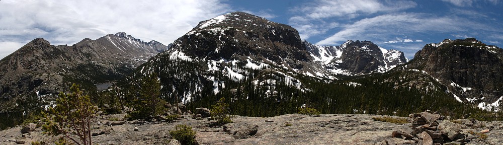
Looking north from Thunder Pass

Knowing now that we’re on the trail to Thunder Pass, we make it a side trip. We cross a shallow trickle of a stream and about forty yards of snow. Signs at the top of the pass demarcate the Park boundary. The view to the south is quite nice, if unspectacular. With our backs to Michigan Lakes, all the mountains in sight are rounded tundra. The lower hairpins of Trail Ridge Road are visible in the middle distance. Longs Peak is not visible.

Rather than backtracking to the outlet of the lower lake for the trail to Snow Lake, we head cross country on a route that will take us gently up the slope to the top of the bench that holds the lake. I thought it was a pretty easy climb. I paused at one point to get my bearings and take in the view when I heard a noise at my feet. It’s typical to find marmots in these jumbles of rock. Usually they bark or chirp to sound the alarm then scamper under a rock. This guy came out onto the rock at my feet and posed for us.

We had to cross the outlet stream, but that wasn’t a problem. The water was mostly running underneath the rocks. Where it was on the surface, it was easily stepped across. There was no krummholz to deal with. The only willow in the area was only inches tall. Wildflowers were varied and abundant, but not particularly dense.

Just before cresting the bench we came across the trail from the lakes below. Here we found columbines covering the ground in front of us. There was a patch of white columbines. I’d heard of white ones, but had never seen any.

From there, it was just a few hundred feet to the lake. The lake sits in a rocky bowl, some snow still draping the rocks on the southern shore. The rocks on this side were two to six feet across, with many that might make nice picnic spots. We worked our way a short distance from the top of the trail where the other hikers tended to congregate.

We stayed at the lake for about an hour. Chad spotted a marmot maybe a hundred yards down the shore. The marmot soon started on his way toward us. He made pretty good time. He was on a mission. It wasn’t until he got fairly close before he worried about staying out of sight.

Two hikers arrived at the lake a minute before us and four or five came and left while we were there, the last leaving just a few minutes before us. We followed the trail down to the lower lake. Or, tried to, anyway. We lost the trail coming down the steep slope. This was pretty much straight up and down the slope; I much preferred the way we went up. I think we lost the trail after wading through waist deep willow. Approaching upper Michigan lake, we cross a talus field. Here, it turns out, the trail splits to a high road and a low road. We took the high road, not really noticing. We were on a trail that went along the top of a ridge line; the other path went beside the lake shore.

Below the lakes we came across three women standing on the trail. They’d spotted a cow moose. We paused briefly and when we continued slowly down the trail the moose was working her way parallel to us a ways off the trail. When we got a bit ahead of her she bolted the opposite way. The three women were behind us, one asking “Was that a moose?”

Back near the ditch we encountered some bicyclists. They had been riding the service road beside the ditch and evidently decided to take a little side trip. Their gear and clothing all looked brand new and they seemed out of place to me. I suspect they didn’t get far up the trail before turning around. I suspect they were much more comfortable along the ditch.

We were back to Ft. Collins by five, where we tracked down first some beers, then tacos. It was a most pleasant day.

Lake Haiyaha

Saturday, July 1

It has been a while since I visited Lake Haiyaha in the summer. I have been there many times, and the last three or four visits were in winter. For me, winter and summer trips to are so different that they may as well not have been the same place.

In winter, I follow a route that I’ve proven I’m unable to find on my own. I’ve successfully navigated to ninety lakes in the park, and I’ve spent a lot of time around Bear Lake. It doesn’t bother me that I haven’t been able to get there without a guide. On the contrary, it makes a common hike unusual. On these winter Haiyaha hikes we don’t encounter many other hikers, which is unusual for so close to Bear Lake.

And, of course, in winter the landscape is totally different. Some gullies get filled in, some drifts are twenty feet deep. You take different routes. In winter, at Haiyaha, the water level drops so much, massive shards of ice make volcano shapes around large no-longer-submerged boulders. So although I’ve been there four or five times in the last ten years, it’s been maybe ten years since I’ve been there in summer. It is time to face the crowds and go in summer.

It’s a short hike, so I didn’t need to be early. I’d park at the park and ride and shuttle to Bear Lake. The line for the bus was the longest I’ve ever seen it, but the wait wasn’t too bad. I was on the trail by 9:15. The route I always take is Bear Lake to Nymph and Dream, then to Haiyaha. The return is down to the Loch Vale trail junction, then either the Fire Trail or by Alberta Falls to the Glacier Gorge bus stop.

Between Bear Lake and the trail junction at Dream Lake, a distance of 1.1 miles, I passed over a hundred people. This is people were standing or sitting trailside or hiking in my direction. Not many people going the other way. Conga-line hiking.

From Dream to the bridge over the outlet of Haiyaha it was much better. I could still hear the voices of people on the trail below. My original plan was to go above Haiyaha a little way up Chaos Canyon. Michael and I did that last time we came here. You get a nice view of the lake, but eastern views are not the most dramatic here. With that in mind, I came across a family sitting on a log, taking selfies. They were right next to a fairly obvious trail, which I followed.

The trail petered out after a while, but I easily traversed a small ridge and made my way to the northern shore of Lake Haiyaha. I’d never been on this side before. The trail dumps you into a large pile of boulders. There’s no shore. Here there are many places one could dip their feet into the water, and there is shade, if you want it. I worked my way a bit farther to the west and found a nice spot with a view of Long’s Peak, a much more interesting horizon than up the canyon above the lake. And, best of all, no neighbors.

Spiders construct substantial webs between the boulders. Sometimes they can be hard to spot. One day, traversing a large talus field, the light was just right. I could spot them from several feet away, and see the spider scramble from the center to safety on the rock as I approached. To say that Lake Haiyaha features a rich insect life might be to understate it. Here, today, the spider webs were easy to spot – they all had dozens of captured insects.

I found a nice spot to relax, a seat in the shade and three feet away a seat in the sun with the flank of Otis Peak front and center, the top of the canyon to the right, capped with heavy cornices of snow, and the erect nipple of Long’s Peak to the left. There was a cloud of gnats not far to my left, but they stayed where they were and didn’t annoy me. The occasional horse fly or curious bee made a visit, but no mosquitoes.

I brought both GoPros with me and the cell phone but not the SLR. I tried to get a picture of the laden spider webs but the cell phone isn’t up to it. I was game to get some nice time lapse footage but there wasn’t a cloud in the sky. Pretty blue skies, but just a shade on the hazy side due to wildfires in Utah. But it was clearly particulate matter and not water – passing jetliners’ contrails spanned fingers only a few inches apart, held at arms length.

I reached my spot at 10:10. I didn’t have any other plans for the day, so in theory I could sit here for something like four hours and still get home by 5:00. Surely in the next hour or hour and a half, some clouds would start bubbling up along the divide.

There was nobody on my side of the lake, but twenty or thirty at any given time on the other side. When the wind was calm, or a light breeze blew across the lake to me, I could hear snippets of their conversations. They were a chatty bunch.

At 11:30 I saw a tiny wisp of cloud above Half Mountain so I started up one of the cameras. This little wisp struggled only a short while, lived only a few minutes. I let the camera run, in case it might make a comeback. Alas, it was the only cloud I saw until I was off the trail at 1:45.

Shortly after noon I decided it was time to pack up. Nothing was happening in the sky. Normally, I sit at a lake for thirty minutes to an hour. I’d been here two hours and enjoyed every minute of it. But now I was hearing voices on my side of the lake, somewhere to my east.

On the way to the trail I found the people I’d heard a few minutes before. I surprised them when I greeted them on my way out. As usual, I headed out the back way toward the Loch Vale trail junction. I wasn’t sure yet whether I’d go by Alberta Falls or take the shortcut. I had this section of trail, from the lake to the junction, all to myself. My solitude ended as soon as I hit the main trail again. Any doubt I had as to my way back evaporated like that tiny wisp of cloud. I’d take the shortcut and avoid the hundreds of people on the trail.

I’m happy that I can hike to a place I’ve been to many times before and still get some pleasure out of it. I’m reluctant to take these shorter hikes in summer because of the crowds. Today was probably one of the busiest days of the year. On my way out of the park, the line of cars at the entrance station stretched to just a few yards short of the Beaver Meadows visitor center. Cars were parked illegally along long stretches of Bear Lake Road, and all the parking lots and pullouts were full. And yet, I was able to find a few yards of quiet trail in the busiest part of the park.

Just another beautiful day in the park.

Bluebird Lake, Almost

Sometime last year my Eagle/Box trip got a few dozen hits in just a couple of days from a MeetUp group, the Grey Wolves. So I joined. I figured if there was a group that went to Eagle Lake, they’d likely go somewhere new for me.

Sunday, June 18

The original plan was that Chad and I would head to American/Michigan Lakes near Cameron Pass. His plans changed. Then I saw an invite from the Grey Wolves for a Bluebird Lake hike. Bluebird Lake isn’t new for me, but could make for a good test drive for joining the group. I’ve been there a couple of times, and will need to go again to collect my last two Wild Basin lakes: Junco and Isolation.

The first time I tried to get to Bluebird was in mid-June of a snowy year. I didn’t make it much past Ouzel. I walked into an avalanche debris field. The avalanche could have happened two days before or two weeks before, I had no idea. The snow was like a giant pine sno-cone. Trees were reduced to their elements – tree trunks, snapped like toothpicks, with no limbs and all the bark stripped off. Branches and twigs of all sizes. All mixed up. The entire forest smelled like a lumber mill. Water coursed down the slope, everywhere, audible under the mass of snow and rubble. It was almost alive. Over the course of eating my picnic, the debris pile visibly settled.

A once in a lifetime experience, no doubt.

Prior to the debris field hike, I attempted Ouzel in mid-June. That time, the section from the Thunder Lake/Ouzel Lake trail junction to the top of the ridge was snow, and the entire meadow below Ouzel was a complex of drifts. So I had a pretty good idea we’d have to hike four or five miles of snow, given the heavy late spring snows this year. Anyway, Bluebird sounded like a nice hike for a June day.

We met at Lyons and carpooled to the trailhead. Got there just in time, as we got the last few parking spaces. We were on the trail at 8. We maintained a nice pace on the trail, although we stopped more than I generally stop. We went through the little bypass for Copeland Falls, which I normally skip. But that’s okay, it’s a pleasant day. The water was running very high. Not the highest I’ve ever seen it, but close.

The lower part of the hike follows the river closely. The sheer volume of water demands attention. It roars. The amount of water was truly remarkable. We leave the river for a while when we cross it at Ouzel Falls. This is the first time I’ve been here since the 2013 floods. The bridge was out for a long time. I’m not sure when it got reopened, but it’s open now. They moved it a few yards downstream. And based on how high the old bridge was, I tried to visualize how high the water had to be to carry it off.

The new bridge is obscured by trees. The old bridge was sited to the left of the tree stump and the trail ran on this side of the log on the right.

We didn’t get to snow until we arrived in the area of my avalanche debris field. Somehow I was in the lead after we all deployed our micro spikes. Shortly thereafter, we arrived at a large rock outcropping. Water was cascading off it. Waterfalls everywhere. The sound of water was ubiquitous, torrents flowing beneath the banks of snow. Watch where you step in the low spots – snow melts from the bottom, often making delicate bridges.

In a few short weeks this area will be a riot of blue and yellow and red and white wildflowers. There are only yellow ones now, though, in bloom inches away from the snowbanks.

Leaving the outcropping we climb a gully to a large talus field. I’d forgotten about it and was thinking we were already approaching the lake. We had one more gully to climb. This final one is narrower and steeper. There is snow in it even into August. Today it’s a wall of snow maybe sixty feet high. I’ve been to the lake before, so I didn’t feel compelled to climb up it.

A few went up, but most of us had our picnics here. The narrow, steep gully on the right leads to Bluebird. The broader, shallow gully to the left leads to Junco. It’s still not clear to me the best route to Junco and this view of the terrain wasn’t terribly helpful, as it all looks so different with the snow.

After lunch we split up. Larry stayed at our picnic spot to wait for those who went all the way. I was in the early group to head back. Around Ouzel I kept my eyes peeled for moose. On the way up, hikers coming the other way reported moose nearby, but I don’t think any of us saw them. I was thinking there’s be a good chance they were still in the neighborhood. I didn’t spot them, but some of the others did.

I had both GoPros with me, but didn’t bother setting them up. There wasn’t a cloud in the sky until after 3pm. There weren’t even any jetliner contrails. The sun was brilliant but even on the exposed ridge wasn’t harsh, as it was still a cool, spring day.

I thoroughly enjoyed the day. I don’t normally do the same trail twice in a season, but I’m thinking I should try to get to Junco this summer. I’m thinking that the talus field below Bluebird Lake might be a good place to leave the trail and look for a route to Junco.


Lake Haiyaha

April 8, 2017

I don’t hike to very many places during the winter. Lake Haiyaha is one I’d like to visit more, but I can’t seem to figure out the route on my own. I used the summer route once, but I didn’t like it and won’t go that way again. So, until I get it figured out, I need navigational assistance. Thus far, that means I have Ed show me the way. This time, it was with a group of internet friends who get together once a year for just this purpose.

I went with the group a couple of years ago. It wasn’t the same group, really, but a different subset of the group. This time I got to meet for the first time a few of the folks I’ve known for a while online.

I find Haiyaha to be one of the more interesting lakes in the area during winter. The water level for all the lakes is reduced compared to summer, but the difference between summer and winter is greater here than any of the other lakes I visit, measured in feet rather than inches.

It was windy at the lake, as is expected this time of year, so we didn’t spend much time there. I set up the camera and we retreated back down the trail a bit for a sheltered picnic spot. When done eating, everybody started back down the trail. I went back to get the camera and caught up to them. I had to backtrack again. I wanted a sip of water and found that I had dropped my water bottle somewhere along the way, so I had to go back up the hill a way to find it.

The route isn’t well-traveled like most of the other places I go in winter. I don’t really care for snow shoes and on my other winter hikes I can get along just fine with microspikes instead. I asked Ed beforehand if spikes would be sufficient but he recommended the snow shoes. I was thinking it was bad advice until we were on the way back. In the morning, spikes would have worked just fine but with the sun beating down on the snow all day conditions got a bit different and I was glad I listened to Ed’s sage advice.

After the hike, Brent and I chatted over beers at the brew pub. The rest of the gang, plus others, got together for pizza later. Unfortunately, I felt the better use of my time was to go home and finish my taxes. Sometimes, adulting is hard.


Two Rivers Lake

Sunday, March 19

I talked Chad into hiking with me. Somehow, two weeks in a row. Last week we took the short hike to Emerald Lake. It snowed the whole time. I don’t know if it technically qualifies as a blizzard, but it was snowing and the wind was blowing. I told him it was some of the most dramatic scenery around. But we couldn’t see any of it.

After many months without hiking, followed by an unsatisfactory hike, I felt I had to do it again. So I asked Chad if he wanted to do another hike, a little longer this time, and hopefully better weather. He didn’t accept right away. Perhaps he finally agreed in spite of his better judgement.

It was a beautiful day, with a forecast high in Denver of over 80. One of the great things about hiking in the Park is that you can get away from the summer heat. It’s only March and it’s a bit distressing that I’m already looking to escape the heat. A March hike along the divide is one way to do it.

Before we hit the trail I warned Chad to be careful whose footsteps he follows. We’d be crossing a couple of open spaces where the footprints get blown away and the “beaten path” might be hard to find. And we need to stay on the beaten path because we’re wearing micro spikes rather than snowshoes. If we get off the path we could be postholing.

When we got to the first of these open areas we met a group of four hikers heading back to Bear Lake. They’d built an igloo and camped nearby. We didn’t find it until we were on the way back; must have walked right by it somehow. It was a big one – sleeps four!

We found ourselves on a fairly well-traveled path, but as we got closer to the lake I began to dislike it. We were following tracks that seemed to take a more difficult route than was necessary. We were climbing too far up Joe Mills Mountain for my taste. Before long we met another couple of hikers on their way back. These two said they visit Lake Helene quite often in the summer, even climbing up the canyon above it to a small unnamed pond beneath Notchtop.

Last year when I hiked here, everybody I ran into thought Two Rivers Lake was Odessa Lake. These two, who have visited here often in summer, told us that Helene was real close and that we’d already passed Two Rivers. They were wrong. What they thought was Helene was actually Two Rivers. It’s funny how a little snow can change the terrain.

Once at the lake, we found a spot out of the wind and settled down for a picnic. Actually, it was more standing around than settling down as all the snow-free rocks that would make nice seats were in the teeth of the strong wind. We opted for shelter in the trees, where there were no good places to sit. We stayed nearly an hour.

We followed a different set of footprints on the way back. On one of the steeper open slopes we spotted below us the route we followed in the morning. Then we managed to get off the tracks we were now following. I decided we were too high up the hillside and the tracks we really wanted to follow were below us. So I headed off into virgin snow.

I knew our morning route was below us but we were descending a bit more than I wanted to, so I decided to contour along the slope. With these warm, bright days and cold nights the snow was pretty crusty. Had to tread carefully, though, as I was often on the verge of breaking that crust and stepping crotch deep into the snow. A few minutes later we came across the beaten path again.

This morning when I told Chad he’d have to be careful whose footsteps he followed, I’m pretty sure he didn’t think I was warning him about me.

Shadow Mountain Tower

Sunday, October 16

Over beers last week I asked Chad if he wanted to go hiking. He agreed, and picked me up Sunday morning at seven.

The trail to the lookout tower starts at the East Shore Trailhead. This is my first hike from here. The trailhead is sited on the isthmus between Grand Lake and Shadow Mountain Lake. There is parking there for fifteen or twenty cars, bear-proof trash cans but no facilities.

We put boots on the trail at 9:30. I should say I put boots on the trail. Chad was wearing trainers. He was concerned they wouldn’t be adequate. I summitted Quandary in sneakers once and my feet were sore the next day. The trails on the west side of the park tend to have fewer rocks and roots than the east side, particularly at lower elevations. I figured he’d be okay.

The weather was pretty good. Denver’s forecast was for 80, sunny, and breezy so I figured 65 and windy at Grand Lake, so maybe 60 and windy at the tower. We passed through a cold inversion layer near Winter Park, upper thirties, but it was closer to fifty when we started. Skies clear but for some small, high, thin ones to the west. And it was windy. I wouldn’t say winds were fierce, but they were high and sustained. I was happy we’d be in the forest all day.

The first mile and a half of the hike is along the north-eastern shore of Shadow Mountain Lake. In a couple of places the trail is inches from the water. These spots were washed by breaking whitecaps today. The forest is mature – almost exclusively lodge pole pine, heavily beetle-killed. The tops of the trees were swaying through arcs of twelve or fifteen feet. We could hear them collide, making a sound like clapping two bowling balls together.

We made pretty good time to the trail junction, covering the 1.4 miles in half an hour. To get to the tower we take a left. The trail climbs to the top of a ridge. The forest on the eastern slope is younger. Mature trees are widely spaced and there is an abundance of smaller trees. I’m guessing a fire went through here half a century ago or so.

2016-10-16-12-01-54sThe tower isn’t on the summit of Shadow Mountain; it’s about a half mile to the west. It’s a stone tower with wooden stairs that wrap around it, leading to an observation deck. The building was built in 1932 and is in the National Register of Historic Places. The Foster guide says the observation deck “provides panoramic views of Shadow Mountain Lake, Grand Lake, and Lake Granby.” This is no longer true. Signs prohibit climbing the stairs due to structural concerns – rotted wood. A plastic ribbon hangs from the banister, no longer barring the way. I really wanted to go up to the deck but I was a good boy. Didn’t make it past the second step.

After our picnic break, we started back shortly after noon. The hike back was unremarkable, for the most part. Until we got back to the section along the lake shore. Dead trees cover forest floors everywhere, to some degree or another. On the Ypsilon Lake trail there’s a section where deadfall is like pick-up sticks. Not quite that bad here, but there are a lot of downed trees. And a lot of the standing trees are dead. I’m generally not concerned about falling trees. Certainly they fall all the time, but it’s a fairly infrequent event.

Of course, the trees don’t so much fall as get pushed over. We heard a lot of creaking wood as we walked down the trail. One dead tree right on the trail was leaning on a neighbor, splitting open at the base of the trunk. You could hear the wood complain as the wind worked on it. A bit later on we heard a crack and a short crash. I didn’t see it, but evidently one tree snapped and fell into the limbs of a neighbor. The crash would have had to be a few seconds longer had it fallen to the ground.

2016-10-16-13-28-49_stitch_resizeWe made it back to the car at two. Some sources say the hike is 4.8 miles each way. Foster has this at 5.4. My Fitbit recorded 22,761 steps for the round trip, so the Foster numbers look correct. With only a fifteen hundred foot net elevation gain it’s a fairly easy hike.

Chad survived without too much difficulty, although he said he wouldn’t have wanted to hike any farther in those shoes.

All in all, just another beautiful walk in the park.

Pettingell Lake fail

Sunday, September 4

Last year, crossing back over the ridge that separates Lake Nokoni from Lake Nanita, I saw what looked to be a fairly well-defined trail crossing the ridge between Lake Nokoni and Pettingell Lake. Having successfully done the 22.2 mile round trip to Nanita and knowing that Pettingell is the same distance, it seemed like I should be able to bag Pettingell.

The weather forecast for Denver predicted a high of 91 with mostly sunny skies and only a slight chance of rain. I probably should have checked the forecast for Grand Lake. Between Granby and Grand Lake the road was wet. I might have thought it had rained in the pre-dawn hours but there was so much standing water it would probably be more accurate to say the rain had just stopped falling. But the rain had stopped, and that’s what counts.

I planned for a 7:30 start, which means leaving the house at 5:30. I was pretty much on schedule, putting boots on the trail at 7:37. Two guys started hiking while I was changing my shoes and I caught them shortly before the first campsite at Summerland. They looked to be traveling oddly light, carrying only a plastic bag containing a couple of rolls of toilet paper. I chatted briefly with them. They spent the night in camp there but managed to forget one important item, thus their early morning trip. They were visiting from Mississippi and had just spent the first of several nights in the park. I expected to see them later in the day as they said they’d be heading to Nanita.

Not long after leaving them at their camp I saw some moose tracks on the trail. I always expect to see moose in these parts but tracks are all I saw. There were these fresh tracks on the trail, still very distinct so I guessed they were put down after the rain stopped. Just moments after seeing these tracks it started raining. Just sprinkles at first, but before long I had to don my rain jacket.

It rained for two hours. It wasn’t a hard rain but enough to cause rivulets of water to run down the trail. Rain drops would hang on the brim of my hat, dance back and forth with my gait for a few steps, then fall to my feet. The rain pattered softly on my hoodie while occasional larger drops falling from the trees made louder plops.

As the morning wore on, I passed several groups of backpackers making their way out. The weather wasn’t exactly conducive to stopping and talking, so we just exchanged greetings. I did ask most of them where they were hiking from; all were in camps along the North Inlet.

It stopped raining after I passed Ptarmigan Creek. About here the trail finally starts gaining some elevation. The first six or seven miles are pretty flat, passing through some wider sections of U-shaped valley where the river meanders in big loops and the occasional pond lies near the trail. After Ptarmigan Creek the trail starts working its way up the side of the valley.

I arrived at the trail junction as quickly as I made it last year. I make a right turn to head to Nokoni whereas most traffic goes on the trail to the left, towards Flattop and Bear Lake. One of these days I’ll have to arrange logistics such that I can hike from Bear Lake to Grand Lake. It’s well over twenty miles, but I no longer have any doubt I’m capable of it.

The roughly two and a half miles of trail from North Inlet Falls to Lake Nokoni is quite the feat of trail making. Last year I didn’t pay particular attention to the trail itself. I took in the views and was always concerned with my progress. More relaxed this time, I couldn’t help but notice how the trail facilitates quick travel.

This is a pack trail, so it is constructed according to whatever codes apply – minimum width, maximum grade, and so on. But the thing that stands out on this section is the absolute absence roots, rocks, and stairs that interfere with your gait. And although I’ve seen many pack trails that have sections that climb four hundred feet in a kilometer, this trail has no steep parts.

But what amazes me about this trail is that it does all this while traversing some incredibly steep terrain. In the mile below Lake Nokoni there are several sections where the trail is literally carved out of the rock. Words and pictures don’t do it justice. These two and a half miles are perhaps the easiest two and a half miles of hiking in the entire park. That, in conjunction with the relative lack of incline on the first six or seven miles make this ten miles of trail easier than many trails half the distance.

I had no sooner stood on the rock shelf along the east side of Lake Nokoni than I heard somebody coming up the trail behind me. It was a solo hiker, a trail runner, and the only person I encountered all day who was older than me. He started where I did, at about eight. His pace was only a couple of minutes per mile faster than mine which was quite the ego boost for me: I’d covered the ten miles in 3:47, or about 2.6 miles per hour.

Now I confess that I forgot to bring a map. I wasn’t concerned, though, because as I said, I saw the trail last year. All I needed to do was find the trail and I’d be on my way. I figured I couldn’t miss it if I just started working my way up the slope. So that’s what I did. The slop turned out to be a bit steeper than I anticipated. I did eventually find a trail of sorts. But it’s loose gravel and I wasn’t happy using it. My footing was much better without the trail. And it’s not really a trail – it fades into nothingness on both ends.

Without a map I was expecting to be able to see the lake when I topped the ridge. So I was a bit disappointed that my target wasn’t in sight. I decided that it must be farther to my left and that I’d need to cross a talus slope. By now it was noon, which is my “bingo” time. I want to be at my destination, or in sight of my destination, by noon. No lake in sight, so I pondered my options.

I could continue, expecting to arrive at the lake within another half hour. That’s not so bad, but it puts my return to the car an hour behind schedule. The rain had stopped, but the sky was still threatening. The only blue sky I could see was a thin ribbon along the divide. The “mostly sunny” forecast looked to be true, if you were east of the divide. Here, it looked like it might rain again. Finally, I’d managed to keep my feet mostly dry until I headed off trail. Once I was walking through grass my pants were wet below the knee and my feet were thoroughly wet. And today I wore my hiking shoes, not the boots. With the boots my feet probably would have stayed dry. And I’d certainly be happier in boots when crossing this talus field. (New rule: wear the boots if the hike goes off trail.)

So I decided to turn around.

No big deal. I can get to Pettingell if I decide I like camping. Or, if I hit the trail at 7:00 instead of 7:40. And wearing boots and carrying a map. (It looks like I didn’t need to cross the talus field after all. That would have been the hard way.)

I cautiously worked my way down the slope back to Nokoni, where I selected a large flat boulder to sit on and eat my lunch. By now the clouds had broken up a little bit, providing alternating sunshine and shadow. I took off my shoes and socks, wrung out the socks, and set them on the rock to dry. But the sunshine was fleeting and a breeze kicked up and my socks never had a chance to dry out. I wasn’t looking forward to hiking ten miles with wet feet.

The weather did clear up quite a bit. Back in the valley, once I got below the lake, I was in sunshine again. The clouds were just hanging around the peaks. About half way back to North Inlet Falls I was finally able to take off my rain jacket for the first time in five hours.

Upper North Inlet valley

Upper North Inlet valley

On the way out I took a couple of short breaks. The Upper North Inlet valley is one of the remotest areas in the park and the steep terrain below Nokoni means the view is often unobstructed by trees. I paused several times to take in this view. I also took a short break at Big Pool to eat some fruit. I was back to the car shortly after five. I was happy to put on dry shoes and socks and surprised that the wet-footed hike out wasn’t the least bit uncomfortable.

Timetable

Up Down
Trailhead 07:37 AM 05:11 PM
Cascade Falls 08:40 AM 04:02 PM
Big Pool 09:09 AM 02:41 PM
Ptarmigan Creek 09:51 AM 02:20 PM
Lake Nokoni 11:24 AM 01:01 PM

Shelf Lake, Solitude Lake

Saturday, July 27

I killed Victor.

We hiked to Shelf Lake and Solitude Lake. I don’t know why I have so much trouble finding where we leave the Black Lake trail. When I hiked to Blue Lake this spring I looked for the spot and missed it. I missed it again this time. We went a bit too far up the trail. We headed across a marshy meadow and made an easy crossing of Glacier Creek and headed upslope.

I heard water to our right and knew we needed to be on the other side of the stream so we worked our way over, passing through some nasty deadfall at one point. When I saw the stream, I also saw the trail and knew we were finally in the right place. I don’t think Victor was much of a fan of our little bushwhacking expedition.

We had just started a kilometer section of trail that climbs eight hundred feet. And it’s not really a trail and there are a few places where you need to use your hands. Earlier in the day Victor had joked about not wanting to do the Bataan Death March and here I am leading him off-trail and then up just about the most grueling kilometer of hiking I could have picked.

Here we ran into some other hikers. Two young guys came up behind us and passed us like we were standing still. We may have been standing still. Closer to the top we chatted with a couple coming down. They’d been up there since Thursday, said they’d had a couple cold nights.

2016-08-27 12.08.36_stitch_crop_scale

Shelf Lake

Above the trees it was quite blustery. The sun was shining brightly but it was cool, and the wind was cold. We had lunch at Solitude, trying to take shelter on the lee side of a boulder along the water’s edge. We needed a bigger boulder.

Even though I didn’t expect we’d want to sit there very long, I attempted to set up the GoPro for a time lapse. There wasn’t much cloud action but you never know how things will turn out. In this case, not at all. I couldn’t get the camera to work in multi-shot mode. It kept emitting a series of beeps, showing a message that said “camera busy.” So no time lapse.

2016-08-27 12.39.23_stitch_crop_scaled

Solitude Lake

By the time we got back to the trailhead, Victor could hardly walk. He may never want to hike with me again, but at least he had a memorable day 🙂

Cony Lake

Sunday, August 14

Cony Lake sits on a bench 11,512′ above sea level, surrounded by Mount Copeland, Ogalalla Peak, and Elk Tooth. It also sits on the southern boundary of RMNP. To get there, you must first get to Pear Lake, which is six or seven miles from the trailhead (depending on where you start). At Pear Lake, follow the trail by the hitchrack. This trail passes a small pond where it crosses the park boundary.

Lower and Middle Hutcheson Lakes are in Roosevelt National Forest. The faint trail leads to the lower lake before heading uphill on the northern bank of Cony Creek. The trail gets fainter and eventually disappears. Route finding from here to Upper Hutcheson can be difficult over terrain of rock benches, grassy ramps, and bands of dense willow and krummholz.

This is the fourth year in a row I’ve set off for Cony Lake. It doesn’t bother me to fall short when hiking in the Park. I’ve almost never had a bad day hiking. Each of the other times I tried Cony were memorable. The first time I had to stop at Pear Lake but got to watch clouds roll in just feet off the surface of the water. The second time I saw a bear sitting on the trail in front of me. Last year I watched an eagle catch a fish.

I started from the Allenspark trailhead rather than the Finch Lake trailhead. It saves a little distance and elevation. I wanted to drive the Chrysler because the parking lot is not Lotus friendly but it was in the shop. It was drive the Lotus or stay home, and I wasn’t about to stay home. There are two entrances to the parking lot at the trailhead. The first one features several large craters but the second is not so bad. I was able to get in and out without scraping.

The weather was ideal. Clear, cloudless sky, a brilliant blue all morning and only a slight breeze, even above treeline.

Over the last few days I’ve spent some time visualizing the hike, mainly the approach to Upper Hutcheson. I saw myself working my way uphill without getting into the willows. I could see the ramp you descend to cross the creek right below the lake. Last year I made it as far as the inlet to Upper Hutcheson and was stymied there. I had stayed along the shore and intended to ascend alongside the creek. It’s not a good route. This time I’d start climbing almost as soon as I got on the other side of the lake, traverse the slope to above the obstructions.

Just as I saw it in my mind, I made my way up without getting stuck in the willows. I crossed the stream right at the outlet of Upper Hutcheson. This is easy to do this time of year when the water level is down somewhat. It’s probably not a good route in July. There’s a nice grassy ramp right down to the water, a few stepping stones and you’re across. I made it the rest of the way without hitting any willow. Instead, it was a lot of rock hopping. Perhaps an excessive amount of rock hopping; I was certainly tired of it by the time I was done with it.

IMG_9704route

My approximate route (drawn on a 2015 photo)

I spent an hour at the lake. I was happy with my pace all the way up. I put boots on the trail at 7:30 and dropped my pack on a rock at the lake at 12:15. It took me fifteen minutes longer going back down, but that includes a stop to refill the water bottle. I didn’t get back to the car until after six, the latest finish I can recall.

The lake is bigger than I was expecting. I sat on a giant rectangular boulder the size of a bedroom, got the GoPro running and tucked into my lunch. There were no squirrels in this boulder field, and there were no birds. A few mosquitoes buzzed me and a few flies were somehow attracted to the camera. It was quite calm, which is unusual along the divide. Some clouds were attempting to cross but were never more than incipient. They got more energetic shortly after I left Cony, some white puffs drifted over Elk Tooth, diffusing the shadows and taking the edge of the bright sunshine.

Coming down from below Upper Hutcheson I ended up in a maze of krummholz and willow. I found myself in a few of the same spots I was in last year, or the year before. I went one way, back tracked, tried another. And another, and another. Eventually I dove through a particularly nasty clump of krummholz and from then on was in the clear, but I’m disappointed I wasn’t able to retrace my steps.

I’m wearing my hiking shoes, not the boots. On the way up I hit my right ankle on a rock, tore a flap of skin. This was situated right above the shoe and when I little toe was uphill of my big toe, that flap rubbed on the shoe. About half my steps when rock hopping had my foot situated that way. By the time I was back on the trail my ankle had gone from irritating to annoyingly painful.

I was surprised at how few people I encountered. On the way up, I exchanged hellos with a group of three and a group of five. I had a brief chat with a fellow from Luxembourg. He hiked Mt. Idea a couple weeks ago, then camped in the Grand Tetons. Then it was the Badlands and a stop in Nebraska before returning to RMNP. His plan today was to lunch in Estes, then drive to the Great Sand Dunes. A pretty cool trip. I met him just below Pear a few minutes before ten.

I didn’t see another person until I was nearly back to Finch, almost six and a half hours later. I’m usually the one asking people where they’re headed, or where they’ve been. Today, though, I was the one being surveyed. After passing Finch Lake, I saw only six people. One young guy coming the other way asked “Finch or Pear?” I told him “Cony.” He hadn’t even slowed down to ask the question, but my answer stopped him in his tracks. “Way to go, buddy!” It was deja vu just after the big trail junction. A guy passing me asked “Finch or Pear?” “Cony.” “Wow”.

It’s been my habit to say something along the lines of “I felt great when I got back to the car.” That would be a fib today. I was pretty fatigued and the ankle didn’t help. It’s not the longest hike I’ve done, or the biggest climb. But I’d say it’s one of the most difficult. It’s a long hike to Pear, then miles of no trail and challenging route finding.

Timetable

Up Down
Trailhead 07:30 AM 06:10 PM
Trail Jct 08:10 AM 05:26 PM
Finch Lake 09:05 AM 04:26 PM
Pear Lake 10:05 AM 03:20 PM
Lower Hutcheson 10:40 AM 02:50 PM
Middle Hutcheson 11:00 AM 02:35 PM
Upper Hutcheson 11:25 AM 02:10 PM
Cony Lake 12:15 PM 01:10 PM

Laguna Seca Trip: Day 5 – Lassen Volcanic National Park

Wednesday, July 13

I awoke about 5:30 but didn’t want to get out of the warm bag. By 6:15, rising was mandatory. The campground was quite still, no one was moving, no one was making any noise. My breakfast is in the bear box, and I was never able to open it without quite a clang so I was an early noisemaker. I had my usual camp breakfast, an apple and protein bar. Then off to hike.

I started with Kings Creek Falls. The guys I talked to last night said I could get there from the South part of our camp or I could take the easy way from the Kings Creek Falls trailhead. I elected for the easy way. It’s marked as 1.4 miles each way. Before starting, I was going to take a picture of the map at the trailhead. Figures, the SLR isn’t working today.

The trail descends from the road. Early on there are signs of recent trail maintenance. Then we get to a broad meadow. There’s a nice view of Lassen Peak from here, when you’re on the return trip. After a half mile there’s junction. Proceed down the cascade section of the trail or take the longer, less steep horse route. But there’s no choice – the cascade section is closed for trail maintenance. Two tenths of a mile from the falls there’s another junction, this one to Bench Lake.

At the falls they’ve built a viewing platform. I poked around a bit, looked at it from the platform and from creekside, but there wasn’t much there to hold my attention. I headed back to the last junction and took the trail to Bench Lake. It was a nice walk, but the lake is more of a puddle, snow fed, with no inlet or outlet stream. It’s surrounded by trees and lacks a view. It also lacks an comfy place to sit and relax, so it was back to the car. Nearly back to the trailhead the work crew, five guys, passed me heading to work. When I first arrived at the trailhead, there was only one other car parked here. Now it’s starting to get crowded – several cars there, with corresponding groups of people heading down to the falls. I reckon this hike to be 4.8 miles total.

Next was Cold Boiling Lake. The guys last night said I shouldn’t bother. I went anyway. First, it’s not like I had a full day of hiking planned. Second, the Bumpass Hell trail is closed. That was definitely on the list but has to be scrubbed. There’s a trail from Cold Boiling Lake to Bumpass Hell. I wondered how far up that trail you can get. So I went to find out.

Cold Boiling Lake is as the guys said, not really worth the bother. And the Bumpass Hell trail from this end is closed a hundred yards above the lake. But the trickle of gasses bubbling out of Cold Boiling Lake is the first sign I see of active volcanic processes. This hike amounted to 1.4 miles round trip.

2016-07-13 10.49.22s

How big is it?

As expected, there is a rich insect life in the area. The bug spray was definitely a sound investment. Here at this rather drab little lake there was an abundance of dragon flies. Walking along the shore the hiker generates a cloud of dragon flies, like Pigpen from Peanuts. All around you for a short radius is a riot of dragon flies. I’m used to seeing maybe a handful of dragonflies in one spot at home. Here they were countless.

I continued south on the Lassen Volcanic National Park Highway, stopped at the Lassen Peak trailhead and again at Lake Helen and Emerald Lake. I briefly considered hiking to the summit. It’s 2.5 miles and about 2000 vertical feet. Difficult, but doable. I made up two reasons not to do it. There’s a lot of snow on the mountain and I didn’t have any spikes. Plus, I could do it tomorrow morning if I want to change my mind.

Just below the peak trailhead are Helen and Emerald lakes. Helen is still half frozen, deep blue water. Emerald is, well, emerald colored. I stopped at the Bumpass Hell trailhead hoping the overlook actually overlooked the place but it doesn’t. You have to hike down the canyon and around a bend to actually get to the place.

Next stop is Sulphur Works. There used to be a spa and sulfur mine here. The road goes a sidewalk’s width away from a fumerole. You park in the lot and take the sidewalk up a few yards to view it. It’s not just a view – you get a lungful of steam and sulfur. The parking lot is also the trailhead for Ridge Lakes.

After finding a shady spot to snack on my trail mix, I put my hiking shoes back on and headed up the trail. Not far from the trailhead I ran into a couple from Denmark. I asked if the trail is this steep all the way. They had only gone a short distance farther to view another bubbler. We discussed where there were hikes that yielded views. I told him that so far, the best views seem to be from the road. The answer to my question, “does it stay this steep” is “No, it gets steeper.”

2016-07-13 13.20.05_stitch_crop_resize

Ridge Lakes

It seemed to take a long time. I stopped quite often. Even so, I was maintaining a two mile per hour pace and caught up to a family very near the lake. At first I saw just the two boys, the older, bigger one chasing the younger with a stick. As I entered the shade they were resting in they were getting ready to continue. “Do you think it’s much farther?” Mom asks. I tell them I think it’s just over this next rise. She’s skeptical; they thought that two rises ago.

I was right, the lake was just over the rise. It was a quite gratifying hike, 2.2 miles round trip, climbing 1,045 vertical feet. Quite steep, but short and surprisingly free of people. I’m accustomed to hiking ten miles to see only six people over a three hour span. The family didn’t stop at the outlet but went in search of a nice place to sit. They took perhaps the prime spot. That’s okay, I wandered around a little.

The lake was quite scenic. Clear water, fed from melting snow. By now I was wishing I had more water. I considered getting water (and using the Steri-Pen) at the lake’s outlet. I was thinking this water would be some of the best water you could get. But I was concerned about it. The Steri-Pen will handle the biological problems, but are there chemical problems? Frankly, it troubled me how clear the water was. A few tufts of healthy looking grass grew with an inch or two of water over them, but I saw nothing growing or swimming in the water. I’d hate to ingest a bunch of arsenic or something. If I was going to fill the bottle, though, it would certainly be here, before it flows through the sulfur canyon below.

2016-07-13 13.32.24sI sat at the lake nearly an hour. A few interesting things: I saw some dirt tubes. I’ll call one a negative, one a positive. The positive are like small speed bumps, solid mounds of loose dirt. The negatives, I think, may have been tunnels but are now trenches. Are they the paths of melt water running underneath the snowbanks? Or did some creature have a network of tunnels under the snow?

I could stay as long as I wanted, thirty minutes or until dusk. Sitting, watching the world go by, sometimes the mind wanders. I pondered the emergency of an eruption. Here at the lake, I could be back at the car in thirty minutes. Quickest way off the mountain is to continue south. I’d have to abandon everything at the campsite, leaving with only the car, the electronics, and the clothes on my back.

In a gross sense, the trees and ground cover are similar to what I see at home, a mountainous pine forest with networks of streams and lakes. The trail is much smoother, though, with far fewer roots and rocks. Much of the ground cover is different. I saw no ferns and lots of Mule’s Ear, a broad leaf flower.

The family outlasted me; I headed down the trail after an hour, more or less my usual visit to an alpine lake. From Sulphur Works I continue downhill to the visitor center at the southern entrance. I got water there, washed my face and hands. I took a quick look at their terrain model of the park but didn’t browse the gift shop.

Heading back to the car I see that a guy is unloading a pallet of freight eight or ten spots downhill from where I parked. No big deal to walk the slope, but not so fun to pull a pallet jack up. I had a pull through spot, saved me the trouble of backing in to a spot. If I’d parked somewhere else, this guy would have had an easier time of it. “Don’t they let you use the loading dock?” The truck entrance is a few yards north of the parking lot entrance. “There’s already another truck there, and besides, my trailer is too long.”

One thing I wanted to do was see if I could get cell service. I almost forgot. I was about to start the car when I remembered. No cell service, but somehow I was able to receive and send text messages. Done with what communication I could perform I retraced my steps back to the campground, getting there just after three.

A lazy evening in camp, being off the trail so early. I relaxed for a while, read some of my book. For dinner I had one of the freeze-dried meals I brought: Chana Masala. The package says it serves two, but the guy at REI said it’s a decent meal after hiking all day. Whereas the rice and tuna was just short of a meal, this was more generous.

Last night we had a few bats chasing flying insects through the campground at dusk. No bats tonight. The only notable guest I had in my spot was a pretty little bird – red head, black and yellow body. Didn’t sit still long enough for a picture.

While looking for bats, a car pulled into the spot across the lane from me. A Mitsubishi Eclipse, a sporty coupe. She was the driver, blonde, skinny. He was the passenger, tall, lanky, with long dirty hair, scraggly Van Dyke beard. Not your stereotypical campers.

They got about eight big grocery sacks of stuff out of their car and spent some time trying to figure out the bear box. Their neighbor seemed to be giving them advice. I kept thinking I’d be putting the tent up if I were in their shoes. Turns out they didn’t have a tent, slept in the car. They built the biggest fire in the park. At one point, they had flames standing eight feet tall. I wondered what the heck they were going to do with all that food.

What with all the light and smoke from campers fires and the growing moon, it didn’t look to be a good night for stargazing. No matter, what else do I have to do? I wanted to listen to Holst’s The Planets but I don’t have a version of that loaded on the iPod. I do have Manfred Mann’s Solar Fire, which is partly based on Holst, so I listened to that. To cap the evening’s program off, it was Astronomy Domine by Pink Floyd.