Today will be our last day of the tour. We will separate from the group at Great Sand Dunes National Park, heading home. The rest will proceed on to Trinidad for another day of scenic byways.
Many times we’ve made the trip from Durango to Alamosa, so I’ll keep the notes short. In keeping with the motif of misinformation about bathrooms, we noted that where there used to be facilities at both the western and eastern feet of Wolf Creek Pass, there is now nothing. Also, we were expecting we’d stop at the scenic overlook on the west side, but that is temporarily closed, being used as a staging area for construction equipment.
Our route bypassed Alamosa, saving some miles. Just east of South Fork we abandoned US 285 in favor of County Road 5, a direct shot toward the park. Well, not exactly direct. At CO 17 we head north a few yards to County Road 6. These roads are no doubt sufficient for their usual purpose: low speed farm traffic. They’re a bit less than ideal for stiffly sprung sports cars. The ride wasn’t exactly quiet and comfortable. Last time I went to the Sand Dunes I was with Michael in the Chrysler. We went between CO 17 and the Dunes at well over 100mph, slowing only for the cattle guards. In the Elise, 65 was plenty fast.
The last few miles into Great Sand Dunes National Park are on CO 150. On that previous trip with Michael both sides of the road were lined with sunflowers. I’m guessing those weren’t there naturally, as they’re no longer there. It was a nice touch, adding a bit of color.
After a short stop in the visitor center, we headed to a picnic area close to the dunes. Mike found us a place with two large sets of tables and plenty of parking. We were the third car there, and right behind us a minivan arrived and started setting up at the other tables. We warned them that we’d have a big group here which seemed to scare them away. As our crew trickled in, they kept coming to the first table and just when it was about full a large family walked in and snagged the other table. No worries, as we early arrivals finished, we gave our seats to the latecomers.
Atop the first dune
The stream that usually flows off the mountain isn’t running right now. I’m not sure when it typically dries up, but I was expecting to have to wade across it to get onto the dunes. Some kids were playing with their toy construction equipment, digging holes, and we could see the sand was wet under the surface. But definitely no stream in sight.
Intrepid explorers Terry and Peter
We walked to the top of the first small dune and people watched for a while. Gordon struck off for the top of the largest dunes. I was thinking it would take a couple of hours, but he made really good progress to the point where I could no longer spot him. I learned later that he was successful. I suspect that made him the last to leave by a large margin.
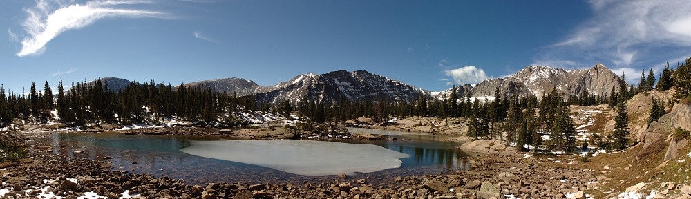
Storm and sand panorama; south on the left side, northeast on the right.
While we were standing around on the sand, a rather nasty looking thunder storm was working its way toward us across the valley. We said our goodbyes and started our trek home. It looked like the group would miss the rain as there was a gap in the clouds above CO 150. But to the west it looked like we’d be running the gauntlet. Almost immediately after turning onto the country road we started getting rained on. But our timing was pretty good. A few miles down the road, the tarmac was covered with the remnants of a significant hail storm. Judging by the few tracks through the hail, it must have just finished a couple of minutes before we got there.
These thunder showers are typically pretty localized. Hailstones lined the road for less than a half mile. And we were out of the rain well before we regained CO 17. Showers were spread out across the valley, their drafts kicking up the dust before them as they scooted toward the Sangre de Cristos. We missed most of them, but it looked like we had another chance to get wet as we crossed Poncha Pass.
We missed the heaviest of the rain until just after the junction with US 50. We were in a little knot of traffic when the clouds burst. I had the wipers going as fast as they’d go, but it wasn’t much help. The windows started fogging up almost immediately. Genae worked the defrost controls, and we had the windows cracked. My left arm was getting soaked. The car in front of us gave up and pulled off the road. We continued at about 20mph. Genae got some napkins out and worked on wiping the inside of the windshield. Then it ended, almost as quickly as it began. Driving the straight lines of San Luis Valley I was complaining that I was falling asleep. This sure woke me up!
From there on home the trip was uneventful. We got back to town just in time for evening rush hour and exchanged the wide-open roads and mountain vistas for bumper-to-bumper traffic and suburban Denver.
Another great Colorado Good! A hearty “thanks” to all who participated, particularly to Mike who put it all together.
Today’s drive was from Montrose to Durango with an extended visit to Mesa Verde. The route was over Lizard Head pass and through Dolores and Cortez. As with most of the rest of this trip, it was a route we’ve taken before. It’s a beautiful route. Our only concern was the timing of potty stops. John has people in Ridgway and told us that there are bathrooms at the park there, so as we passed through town we dropped out of line and into the park. Sadly, John’s info was bad and there were no bathrooms to be found. So we were tail-end Charlie again.
We caught the group before long at a wide spot on the road just before Telluride. We weren’t going to Telluride, but making a right turn near there. This wide spot was an opportunity for a group photo. John’s next piece of info was that there were no bathrooms at the summit of Lizard Head pass, so we figured we needed to stop before then.
Obligatory group photo
At the right turn there’s a gas station, so we again dropped out of the queue. Just as we approached the summit of Lizard Head we caught up to a motor home. I was looking for a way around it when I caught a glimpse of orange in the parking lot. We weren’t expecting a stop here. It was the original target for the group photo, but as that was already taken care of we thought we’d be skipping it. Turns out John’s second piece of intel was incorrect, too. There are, in fact, bathrooms at the summit of Lizard Head pass. It was our error to doubt Mike.
The drive from Montrose to here at the summit of Lizard Head Pass is gorgeous. Mile after mile of fantastic views – snow-capped peaks and aspen groves – connected by roads that curve and swoop, rise and fall. There are many scenic drives in Colorado but this one certainly goes near the top of the list.
The Galloping Goose
Our next pit stop was in Dolores. Our chosen gas station here was next door to the an old train station that now houses the Galloping Goose Historical Society. In the 1930’s the Rio Grande Southern Railroad was facing financial difficulties. They came up with an interesting solution: the Galloping Goose. It’s a railcar operated by motor rather than steam, much lighter (and therefore reduced impact on the railroad), and has a front-end that looks like a bus. Seven of these were produced, and the one here in Dolores operates as a tourist attraction.
From Dolores we headed to Mesa Verde National Park. We weren’t sure if the restaurant in Mesa Verde was open yet, being early in the season. So we made a detour in Cortez to stop at the Subway for sandwiches. We left Dolores before the rest of the pack but still ended up at the visitor center after everyone else.
Genae, having lived a while in Durango, has visited Mesa Verde many times. I have been here a few times, last being in 2013 when I hiked to Petroglyph Point. I never really explored much of the park, having each time had a specific goal in mind. A few days prior to this trip, Genae had intended to go online and book some tour tickets. That never happened, and when we went to the ticket counter in the visitor center we found that (surprise, surprise), the day’s tours were already sold out.
Cliff House
So we were free to explore at will and see what there was to see. First task was to stop at the restaurant at the Far View area (which was, indeed, open) for beverages to go with our Subway sandwiches. We ran into Peter and Rebecca there. They said they’d never been to Wetherill Mesa before so that’s where they were headed. I’d never been there, either, so that sounded like a good place to go. Unfortunately, I immediately made a navigational error and we ended up on Chapin Mesa, which is where most people find themselves.
So we worked our way to the loop that takes us to Cliff House and Balcony House. Cliff House is closed for the season for reclamation work. There’s an overlook that gives a nice view of it, but we couldn’t visit it. And Balcony House is reachable by guided tour only, and sits in an alcove pretty much underneath the parking lot, so it’s invisible as well as unreachable. So that whole loop was disappointing.
Spruce Tree House
Next we headed to Spruce Tree House. This one is a self-guided tour, but the path to it is having some structural issues, so it’s closed as well. At least it’s visible. I was thinking the trail to Petroglyph Point takes hikers right in front of the ruins, but signs indicated we wouldn’t get a better view than where we stood, so we didn’t go any farther.
Yucca in bloom
So we got back in the car and headed to Wetherill Mesa. This turned out to be a nice little Lotus road. We encountered very little traffic, which added to the pleasure. The road is a bit on the rough side, but not terribly bad. It’s quite a drive to the end of the road where the ruins are. For future reference, count on the Long House tour taking half a day. The tour itself takes two hours, and if you drive the speed limit you can count on another forty minutes or so driving each way.
Not having tickets for the tour, our only activity was the self-guided tour of Step House. So, after spending a few hours wandering the park, we finally got to tour one of the ruins. In a way, this one is more like two ruins. One side of the alcove features the pit houses of the “Basketmakers” who occupied the place circa A.D. 600. The other side is a small multi-story pueblo built about six centuries later. It is estimated that about thirty people lived in each settlement.
Step House
Driving between the sites one can’t help but notice the frequency with which the area is subject to wildfires. The dead trees still standing in the 2002 burn area are still black. Signs along the roadside indicate other fires. Between 1989 and 2003, five fires burned over half the acreage in the park. Thunderstorms range over the area all summer long, and about 95% of fires here are started by lightning.
Overall, Mesa Verde was a bit disappointing due to our lack of proper planning (no reflection on Mike, of course, I’m talking of our own preparation) and that so many of the ruins are closed this year. That means, on the flip side, that there are still plenty of sights to see the next time we visit the place.
Durango & Silverton Narrow Gauge Railroad
Back in Durango, the group went out to dinner. We elected to go our own way and instead dined with Grace. We requested a brew pub and she recommended we go to Brew Pub and Kitchen. (Break the usual cadence when you say it, though: it’s not “Brew Pub” and “Kitchen”, it’s “Brew” “Pub and Kitchen”.) It’s right next to the narrow gauge line. While waiting for our meals a train pulled into the station. It’s quite the conversation stopper.
They have an unusual naming convention for their beers. They have “Darlene”, a Belgian ale; “Kelley”, a stout; and “Jesus”, their “righteous yarrow double IPA”. I passed on those and instead had a couple pints of “Greg”, which their menu says is “an easy drinking Kolsch to inhibit your social graces”. Naturally, Grace had to call Greg to pass on this little tidbit.
The Colorado Grand is an annual charity tour over the highways and byways of Colorado. The Colorado Good is a Lotus Colorado tour that has almost nothing in common with it. They drive 1960 and older sports cars and cars of distinction. Our cars are almost never that old, but are often distinctly colored. They attract entrants from around the world, ours come mostly from the Front Range. They get help from the State Patrol, we generally try to avoid the State Patrol. They have a storied history of charitable giving, we tell a lot of uncharitable stories.
As has been the case for the last several years, Mike was again the organizer. He did another great job, with this edition taking us through some of Colorado’s finest scenery with overnight stays in Montrose, Durango, and Trinidad, and visits to three outstanding National Parks. I think this is the club’s twelfth Colorado Good, but I may have lost count. It is the seventh that Genae and I have taken part of. This one was a big trip – a bit too big for us so we cut it short, skipping the final day. But I jump ahead. Please allow me to begin at the beginning.
Saturday May 19
As I said, most of the participants come from the Front Range. We can break the Front Range folks into two groups: those from Denver or thereabouts and those from Colorado Springs and environs. But that’s not particularly important. The drive officially begins at a Shell gas station in Johnson Village, a wide spot in the road a few miles south of Buena Vista. Typically, those of us from Denver make a token effort to gather together for the drive down US 285. Mike left us to our own devices to arrange a caravan, and those devices weren’t working. That is, we all made our own ways to the assembly point.
Had the group met at our usual jump-off spot, the parking lot at The Fort restaurant, we’d have done little more than wave hello as we passed. Our intention was to stop at the Wendy’s in Conifer for breakfast and bathroom. Genae checked their website and learned they open at 7am. Unfortunately, this turned out not to be the case and would prove to be a foreshadowing of a minor motif of the trip for us: misinformation regarding potty stops.
We were thinking we were likely ahead of many of the Denver folks and thus under the delusion that we’d be one of the first cars at the rally point. We’re typically one of the last cars to arrive. We remained true to form and found ourselves to be one of the last cars there.
Two of the cars on this trip started on the Western Slope: an Elise from Gunnison and a Europa from Dolores. John made the drive here from Gunnison but we wouldn’t be meeting Barry and Anne and their Europa until later. Nevertheless, I’ll provide the full census of cars here: we were six Elises, three Europas, an Evora, an Elan +2, an M100 Elan, a Westfield 7, a Mini, a Jaguar XKR, a Porsche Boxster, and a BMW.
In the final moments before we departed, Gordon asked me for a little mechanical assistance. I told him a little was about all I was qualified to give. All he needed to do was reattach the panel under his engine, the one you remove to change the oil. It wasn’t on quite right and it needed to be adjusted. We made the adjustment and tightened down the large bolts. All he needed to do was attach the thirteen or so small bolts and he’d be ready to go. I’m not sure how long it takes to do this, but I am sure we were all out of the gas station before he had any chance of completing the task. So we essentially pulled a “Top Gear” on Gordon, leaving him to deal with his stricken car all by himself.
I felt pretty bad about this so I assumed the position of “tail-end Charlie”. I lagged a little, checking the mirrors and hoping to see him catching up. But I knew he was quite a bit behind us. I asked Genae if we should wait at the navigation point in Saguache for him to catch up, but she said he’d be okay. I’m guessing that the Top Gear guys have plenty of time to catch up to their associates, as everybody is probably spending as much time making a film as they are actually going anywhere. We, on the other hand, don’t lollygag around, and are lucky if we can keep to within single digits above the posted speed limit. We may not see Gordon for some time.
In my reports of these drives I’ve been known to spend a lot of time describing our route. But because we’ve done quite a few of these it’s a challenge to come up with roads we haven’t been on before. That is very much the case today. So while Gordon is pedaling furiously to catch up to the group I will go off on a bit of a tangent, now having the opportunity to describe a new road.
Heading south on US 285 in the northern end of the San Luis Valley we find ourselves in the little town of Saguache. It is perhaps one of the most mispronounced place names in the state. The proper pronunciation, or at least the way the locals pronounce it, is along the lines of “sa-watch”. It’s a Ute word that refers to the range of colors that includes both green and blue. Some modern Ute speakers say it refers to green vegetation while others maintain it refers to some bluish stones. In any event, Saguache is where we leave US 285 and head north on CO 114 and begin a 67 mile stretch of road I’ve never been on before.
The literal high point of this stretch of road is Cochetopa Pass. Actually the road goes over what the sign says is North Cochetopa Pass. But no matter. “Cochetopa” is another Ute word, this one for buffalo. (And when I say “buffalo”, I of course mean bison.) This pass was the original ancient all-weather Ute and buffalo trail linking the San Luis Valley to Gunnison country. It also figured in the first penetration of the Rocky Mountains by Europeans. Governor Juan Bautista de Anza crossed it in late summer of 1779 when he was chasing a group of Comanches led by chief Cuerno Verde. I don’t know of any places in Colorado named for de Anza, but just east of the Sangre de Cristo mountains you’ll find Greenhorn Mountain. Cuerno Verde means “green horn”.
The Rio Grande River flows through the southern part of the San Luis Valley, so it would be natural to think that the streams that flow from the mountains on the northern end of the valley are Rio Grande tributaries. De Anza learned that this isn’t true. These streams, like the ones that pour off the western flanks of the Sangre de Cristo mountains above the Sand Dunes, just disappear.
We had a much easier passage to the Gunnison drainage than de Anza had 239 years ago, as the northern end of CO 114 is a nice Lotus road. Our greatest difficulty was finding places to pass the cattle trucks and lumber trucks we came upon. It was while attempting to dispatch one of these cattle trucks that I noticed a green Elise coming up behind me on the double. Gordon had caught up to us. (“How did you catch us so quickly?” I later asked. “I spent a lot of time over [redacted]. It was fun!”)
After we ate lunch at Legion Park in Gunnison we headed to Black Canyon of the Gunnison National Park. Here you’ll find some of the steepest cliffs and oldest rocks in North America. Over a period of about two million years, the Gunnison river cut a deep gorge through 1.7 billion year old gneiss and schist. The river drops an average of 96 feet per mile in the park, falling more in 48 miles than the Mississippi River does in 1500 miles.
Painted Wall – at 2,250′ it is the tallest sheer cliff in Colorado. Can you spot Gordon?
Arriving at the park’s entrance station we asked for an interagency pass as we’d be visiting three parks on the trip. The ranger, though, was all out of them. So he let us in for free. “Make sure you buy your pass at the next park you visit.” We will do exactly that.
After a brief stop in the visitor center, the group broke up. Our next group activity was dinner in Montrose and we had a few hours to spend in the park so we headed to the western end of South Rim Road. There are a number of vantage points along the road with names like Dragon Point, Pulpit Rock, and Cross Fissures View. It seemed to me to be a good idea to start at that end and work our way back, but it turns out all the parking spots are on the rim side of the road. So our retrograde path meant we’d be parallel parking facing the wrong way every time. You can’t take me anywhere.
Chasm View
This is fairly arid country, made somewhat worse by the extreme drought we find ourselves in at the moment. One of the rangers there told us that the river is flowing at only about fifty percent of it’s normal for this time of year. In spite of that, most of the shrubs along the rim are in abundant bloom and this is perhaps the prettiest time of year to visit.
Pulpit Rock and another episode of “Can you spot Gordon?”
Having stopped at almost every vista along the road we exhausted our allotted time. We made our way out of the park and into Montrose a few miles down the road. We got checked in to the hotel, then headed to dinner at a restaurant called Camp Robber. They sat us outside. It was a bit cool, with a breeze and we got sprinkled on once or twice. We didn’t know we were going to sit outside, so we weren’t prepared. I had my jacket in the car and gave it to Genae. I was pretty cold by the end of the meal.
I had a salad – Parmesan encrusted chicken on spinach, with strawberries and pineapples, tomatoes, onion, and strawberry vinaigrette dressing. The soup was hatch green chili potato soup, tasty with a bit of heat. I enjoyed the meal in spite of the chilly conditions.
It’s time for the spring running of Emich’s track day at HPR. I signed up for the afternoon sessions only. It’s a good bargain – four half hour runs for $85. It’s always a crowded day because I’m not the only bargain hunter. This year it sold out. But I figure many of the folks who sign up for the entire day leave early so the last couple sessions will feature a lot less traffic.
Today it seemed like the mix of cars was a bit more upscale than in the past – the vast majority of the cars were new Mustangs, Porsches, Corvettes, and Camaros and not so many older cars. In fact, I don’t think there were more than a handful of cars older than mine.
Scott and I drove out together and got there just in time for the drivers meeting. When we pulled in, I figured we’d park close to the pavilion so we wouldn’t be late for sign-in and the meeting but as we went by the carports Ryan flagged me down. There were two slots that morning entrants had paid for, so we snagged them.
The runners
So the Lotus contingent for the day was Ryan, Scott, and me. Unfortunately, Ryan again had injector issues. Not the same injector as last week, but evidently the same root cause. He thinks he has the solution and expects to be ready to go for next time. I hope he’s correct.
Ryan already in the trailer
Not much else to report.
I checked the settings on the lap timer and found where to connect it to the OBD II dongle, so I collected a limited amount of engine data. And I finally bought the unlimited version of Race Render 3 for making my videos.
I’m quite happy with it so far. It greatly simplifies the process. Before, I had to use my video editing software to do the picture in picture. It takes it about two and a half hours to complete that process. One thing that bugged me about it was that the rear-view camera isn’t a mirror image. That is, when I get passed by a car on driver’s right, the car goes to camera left. I couldn’t find any option that let me flip the image.
Race Render 3 does the horizontal flip of the rear view camera automatically. And it does the rendering in a few minutes. It also makes it fairly easy to sync everything up. I advance the main video to the first time I cross the start/finish line, adjust the rear camera to the same point (it will be off by several seconds – the time between starting the cameras). Then, for the data, tell it to find the start of lap 1. Bingo – all synced up.
The lap timer handles the GPS, so that’s the source of position and speed. The OBD supplies RPM and throttle position. I can also get coolant temperature and intake temperature. I may play around with this data next time. Throttle position percent comes through in the range of 14.9 at the low end and 77.6 at the high end, rather than 0 and 100. I edit the gauge display to adjust for that and it comes out okay. The ODB also records speed, so I may play with using that rather than the phone data. I haven’t checked yet if they match.
I’m open to suggestions for the display, so feel free to leave comments.
The first CECA event of the year is at Pueblo Motorsports Park. I’ve only been there twice, and I think the last time was back in 2012. So it’s long past due for a visit. The day after I popped my check in the mail I received an email saying that the event would be cancelled if they didn’t receive eight more entries. Turns out they got twenty.
The hitch in the plan is variable spring weather along the Front Range. A week ago, the forecast was for a high in the upper fifties with snow and rain in the morning. Well, I figured, if it was going to get near sixty, any snow would melt as soon as it hit the ground. And although I’ve never run laps in proper rain, I’m up for it. Wet conditions would mean my street tires might be an advantage rather than a detriment.
CECA fees are a bit higher than a typical open lapping day, but there is one big advantage: entries are by the car rather than the driver. That means we can have Michael drive a session or two at no additional cost. So I put his name on the entry form as second driver and told him to plan on spending the entire day with me.
The fly in that ointment is that he went to a concert last night and didn’t get home until 2:30. It’s a two hour drive to the track, and we needed to be there before the start of the 8:00 drivers meeting, so I told him we’d leave no later than 5:30. He said he’d set his alarm for 4:45 and be ready to go. There were no signs of life downstairs so I woke him up with a question: “Are you coming with me?”
I had the car all packed up last night, so even with him getting a few extra minutes of sleep we were on the road by our desired time. At 5:30 we backed out of the garage and into a snow storm. I don’t normally drive the car in the rain, unless it’s unavoidable. Snow is out of the question. I’m not running track tires, but they’re summer tires and not made for snow. But we’ve had warm weather for a while, and the snow will melt as soon as it hits the ground, right? Right? That’s what I kept telling myself.
The Elise is neither quiet nor comfortable, but as Michael had only a couple of hours of sleep he was unconscious almost immediately. It was probably just as well. It was a bit of a white-knuckle drive much of the way. I’m not a big fan of driving the Elise in the dark, as it sits so low. Add the snow (even if it was melting right away) and visibility was bad – very difficult to see the lane markings, and the spray from other cars didn’t help. Add to that, there was a fair amount of standing water on the road; I hydroplaned occasionally.
Visibility improved once I got out of the city, and traffic thinned out a bit. At speed, the snow doesn’t really hit the windshield, so the snow didn’t look to be too heavy. Until I passed the occasional street lamp, when it looked far too much like blizzard conditions for my taste. The test of the weather would be at Monument Hill, which is notorious for bad weather. On the approach, it looked like the snow was starting to stick to the shoulders of the road. Because the snow flew over the car, I didn’t often need to use the windshield wipers. By now a line of slushy snow had accumulated underneath the wiper.
The weather seemed to be clearing as we went farther south. Just as snow had been stacking up under the wiper, it has been accreting on the nose of the car. Near Fountain, a big slab of it came loose and splattered on the windshield. But the worst of it was over, and the snow had turned to light rain. Even so, I couldn’t help but wonder if the conditions had caused enough people to bail out that we would cancel.
When we arrived at the track it looked like a fairly sparse crowd, but at least we weren’t the only ones who braved the conditions. We gathered in the “VIP” room. I use the term loosely. It’s air-conditioned, which I’m sure is welcome in summer. But there’s no heat. At least it was dry, and out of the wind.
When we first pulled into the facility, I saw an orange car on a trailer. From a distance, it might have been Ryan’s Exige, but he doesn’t trailer his car. Turns out it was a Viper, not a Lotus. In fact, it was a Viper TA, which doesn’t stand for “Trans Am” but for “Time Attack”. It’s an 8.4 liter V10 that pumps out 640bhp. I understand they were available in two colors: orange or black.
Viper TA
And it turns out Ryan recently bought a trailer, so he now trailers his car. We parked side-by-side and rather than lay out our things on a tarp on the wet ground, we stashed our stuff in his trailer.
He mentioned that he recently had a problem with one of his fuel injectors and hoped he had it fixed. This proved to be a bit of foreshadowing.
After our tech inspection, we went back to the VIP room for the drivers meeting. We still had some waiting to do, so spent the time visiting. I took a look at the entry list and saw 28 cars listed. Turns out it was somewhat less, as some people didn’t brave the weather after all.
1969 Shelby GT 350
As this was Michael’s first time, he had to take the ground school session for the novices. The red group was out first, which included me. While we were waiting for the drivers meeting to start, we watched them trying to dry the track, or at least the drag strip portion of it. They had the brushes out, and a blower. It had stopped raining, but our first red session would be under yellow flags because of the wet. For that first session, I didn’t bother setting up the cameras.
Michael’s first session was a “lead-follow” session. The idea is, all the novices line up behind the instructor car. After the first lap, the car immediately behind the instructor lets all the other cars pass then gets back in at the end of the queue. The process is repeated each lap until everybody has had a chance to follow right behind the instructor.
The Lotus contingent
Because I was in the red group, Michael didn’t get to line up with the other green group cars on the grid. So he would be released after everybody did their first lap and he’d be at the end of the line. Unfortunately, three cars in the group were unable to keep up to the line, and because we enter the track down the pit lane, by the time we got on the track even this last group of three cars was well ahead of us. So I had to put my instructor hat on and try to tell him the line.
Eventually we caught the pack. But for some reason, a few of these drivers seemed unable or unwilling to follow the rules. Instead of just the lead novice letting the others pass, two or three cars did this each time. As a result, we made our way up to the instructor pretty quickly. After our one lap, we tried to go to the back, but a couple cars stayed behind us and after three more laps we were back to the front. That was good for Michael, as he got a couple of nice looks at where to put the car.
The weather seemed to be improving a bit, so for my next red session I took the top off the car and mounted the cameras in their usual places. The track was nice and dry now, and we could finally give it a proper go. In my previous visits to PMP, my personal best lap time was 2:01. By my fourth lap of this session I’d matched that and before the session ended, I’d broken the two minute barrier three times, logging a 1:57.67. I was happy with that, particularly given that I had a passenger.
About half way through the session, though, we saw Ryan parked on the side of the track. When we got back to the paddock we learned that he’d had a recurrence of his fuel injector problem. Sadly, his day was done.
It was now lunch time, so we returned to the VIP room. Michael and I got burgers and fries. Sitting there eating, I couldn’t help but notice that the rain had started up again. It wasn’t particularly heavy, but I’d left the top off the car. I was more interested in having a hot lunch than running out in the rain to put the top on the car. Luckily it didn’t rain hard or long, so neither the car interior nor the track got very wet.
Michael was pretty cold. Neither of us was properly dressed. We were expecting temperatures in the high fifties, but I don’t think it managed much more than fifty, and with the breeze it was fairly chilly. I couldn’t wear my sweater under my driving suit, so I wore my jacket over it. I was happy to put the top back on the car, and even ran the heater. So for the next red session, I went out solo while Michael tried to keep warm in the VIP room.
That third session was much fun. I managed seven laps in a row under two minutes. There was very little traffic by now, many people having given up. I only caught up to two cars, and those on the first two laps. If there were any faster cars on the track, we were separated by quite a bit as nobody passed me the whole time. In the end, I logged a new personal best lap of 1:54.56.
By now I was getting low on fuel. Because the paddock is inside the track, nobody can leave while a session is in progress. So, rather than pack up our stuff and wait in line to exit, we decided we’d run two or three more laps to pass the time. I called it a day at the end of three laps when I had a big moment. I didn’t spin it, but got quite a bit sideways.
Once we were packed up, the track was closed for a break and we were able to exit without having to wait.
Michael did a great job behind the wheel. There’s a lot to take in the first time you’re on the track. It’s easy to get focused on the road in front of you but you need to be check out the corner stations and have to be aware of your mirrors. He did watch his mirrors very well, but I’m not sure he was looking for the corner workers. That’s easy for me to do as passenger, so I wasn’t terribly concerned. If I thought he’d have missed something, I’d have let him know. I had the lap timer running, but not where he could see it. It’s natural to want to know how you’re doing, but I didn’t want another distraction for him.
Due to the blustery conditions, I ran all but one session with the top on. So the video is from the harness bar mount rather than my preferred location on top of the car. And I still haven’t figured out what I’m doing wrong with the lap timer – I seem to be disconnected from the OBD dongle, so no data. Hopefully I’ll get that issue wrestled to the ground soon.
Before I started this blog I had been posting trip reports to a forum for lovers of Rocky Mountain National Park. This is one of those reports, with only minor edits for clarity.
Hike date: 12 August 2012 — Originally posted: 13 August 2012 – 11:25 PM
Sunday I hiked to Mirror Lake.
I don’t normally say anything about the drive to the trailhead, but I’ll make an exception this time. The Corral Creek trailhead is 8.5 miles up Long Draw Road from CO 14, which passes through Poudre canyon. The Poudre river and CO 14 were the battle lines on the north side of the recent High Park fire. I nearly wrote that this was my first time through the canyon since the fire, but that overstates it. I’ve lived in Colorado for something like 33 years and this was my first trip up this road. I’ve been on a number of other roads in the area, once with the Lotus club through Rist Canyon this spring. (I have video of that drive and intend to go there again soon. I’ll see if I can put together a before/after video of the fire damage) There are a number of “Thank You Fire Fighters!” signs still posted. Some mountains are completely burned but most places in the canyon are burned in a mosaic pattern. Burned areas are black – black tree trunks and black ground – and are surrounded by brown borders; trees that are clearly dead, baked by the fire. Undamaged forest is outside these brown borders.
Long Draw road is near mile marker 69, well west of the burn area. This is a dirt road, well maintained but a sign at the junction indicates it’s a “Level 6” road. That has something to do with how often it’s plowed in winter, but the sign is quite verbose and I didn’t bother to read it. I also missed the first sign that says the road will be closed indefinitely beginning August 14 due to logging operations. If you want to hike in this area, better find out if the road is open. For anybody in the Denver area planning to hike here, note that it’s a three hour drive from the northern suburbs. I can make it to trailheads on the west side of the park in about two hours, so this one is probably the longest drive from here. I’d hate do drive 3 hours only to find the road is closed.
The hike is about six miles from trailhead to lake, but only about a thousand feet of net elevation gain. I figured I’d be able to make pretty good time, being it’s a pretty level trail and guessed I could make the lake in three hours. Working back, that meant arriving at the trailhead by 8:30 or so, which meant a 5:30 departure from the house. Again, assuming a two mile per hour pace, I should be able to spend an hour at the lake and make it back to the car by 3:30 and home by 6:30. For once, I managed to keep pretty close to the plan.
The first mile of the trail is outside the park. From the trailhead, it descends about 300 feet to a spot near the confluence of the Poudre and Hague’s Creek. The area is comprised of wide, U-shaped valleys with large meadows with the trail running along the edge of the forest. The park boundary is right at the Cache la Poudre and the park boundary sign is nailed to the first tree on the park side of the bridge.
After a couple of miles and another bridge (crossing Hague’s Creek), the trail leaves the valley floor and climbs the side of a ridge. This middle third of the hike is where all the elevation gain is made. There are a couple of short sections which each climb about 400 feet. The final third of the hike is again more or less level. After the climb the trail meets the stream coming from Mirror Lake as it passes through its own series of meadows. Here the trail gets a little vague, I even lost it once or twice by the campgrounds. Shortly after the third Mirror Lake campground, you climb up some rocks and are deposited on the shore of the lake beside the outlet. The lake is bigger than I was anticipating. It lies beneath some unnamed mountains and if you look along the outlet stream you get a nice view of the Mummy range in the distance. The hike doesn’t really have any great views as it forested the whole way. The forest is fairly thin, with lots of green ground cover.
I encountered a park ranger and seven other hikers all day. And I ran into all of them on the short spur trail between the Mummy Pass trail and the lake; nobody at all the rest of the way. I was expecting to see moose but they were all elsewhere. The only wildlife I saw was a grouse that crossed the trail in front of me early in the morning. At least I think it was a grouse – he (she?) blew up some sacs in his throat and made a sort of bullfrog noise. Even though the forest here is fairly thin, there were still several trees that had fallen and blocked the trail. On the hike out, I was doing some calculations, trying to come up with the odds of having a tree fall on me. “If tree X is going to randomly fall over this month, what are the chances I’m walking by when it happens?” I’m figuring most dead trees fall over during storms, or when it’s windy and working through an estimation of the number of dead trees on any given mile of trail. As I’m working through this, on this nice calm day, I’m approaching a dead tree. There’s an odd noise and I look up to see a branch falling off! I easily jumped out of the way, but I have to say it was a bit freaky to have this happen given my train of thought.
All in all, a wonderful day. The weather was excellent and the hike quite pleasant.
Before I started this blog I had been posting trip reports to a forum for lovers of Rocky Mountain National Park. This is one of those reports, with only minor edits for clarity.
Hike date: 04 August 2012 — Originally posted: 05 August 2012 – 12:22 PM
Lewis W. Keplinger was a student of John Wesley Powell at Illinois State Normal University. Keplinger was a member of Powell’s expedition that first successfully climbed Long’s Peak in late August of 1868. The group first attempted the summit by starting near what is now Lake Powell. They climbed the sharp ridge that connects McHenry’s Peak with Chiefs Head and Pagoda Mtn. They found themselves cut off from their destination by “impassable chasms.” They retreated and made camp near Sandbeach Lake. The next day, Keplinger set off on his own to reconnoiter. He found a couloir winding up the south flank and managed to reach within several hundred feet of the summit before returning to camp after dark. On August 23, the group set off on Keplinger’s route at 7am. In a couple of hours they had attained his highest point where another member of the party remarked that no man could scale the point and live. By 10am, the party made the summit, led by Keplinger.
The hike to Keplinger Lake has been on my list for a couple of years, but I’ve been a bit afraid to attempt it. It’s something like 4 miles of hiking off-trail, and as none of my friends wants to hike with me, I’ve been thinking it’s too much off-trail for me to go solo. But I finally talked myself into it.
I hit the Sandbeach Lake trailhead at 7:30, about a half hour later than I had intended. The forecast was for cool weather, perhaps some rain, and the sky was overcast on the drive up from Denver. There was one little bit of clear, blue sky visible to the west and as I hiked the clouds evaporated leaving a pleasant sunny day with scattered fluffy clouds. The hike to Hunter’s Creek (about 3.2 miles) is pretty basic. The first section reminds me of the first part of the Lawn Lake trail – a fairly quick climb of about four hundred feet, then leveling out somewhat. I reached Hunter’s Creek at 9am.
A hiking report I found on another website said you head up the “faint” trail at Hunter’s Creek. This trail is quite easy to follow, except for the occasional spot where it is interrupted by recent deadfall. I’m guessing this trail is used mostly by folks climbing Long’s using Keplinger’s route, as to continue up Hunter’s Creek you must leave it where another stream meets the creek. From here on, there really isn’t any trail and the bushwhacking begins in earnest.
The forest thins out about this point and soon the hiker is presented with a nice view of Pagoda Mtn. The creek climbs steadily but not very steeply. I found it was often easier hiking to stay ten or twenty yards away from the creek. Before long a large snow bank becomes visible on the flank of Mt. Orton. The creek bends a bit to the right (north) and leads you into… not krummholz exactly, but the same sort of stuff – waist deep shrubbery. I found my way to an outcropping of rocks which put me on the southern shore of the unnamed lake lying about 11,200′. The view was incredible. By now it was 11:30. After a quick look around, I decided the best way to continue to Keplinger would be to back track a bit and cross Hunter’s Creek. I also decided it would take me another hour to reach my destination. Faced with another hour of hiking, or sitting here enjoying the view and eating my picnic lunch, I decided to save Keplinger Lake for another day.
Here’s a time lapse. It’s becoming clear to me that the GoPro isn’t up to the task. The automatic exposure control wreaks havoc on the results; whenever clouds shadowed the camera, it overexposed the view of Pagoda and Long’s. Oh well.
After about an hour I headed back down. I felt great all day, never particularly fatigued, and was making better time than normal at the end of the day. That ended when I got to that steep part just above the trail head. Dang big steps played havoc with my knees.
I didn’t make it to my intended destination, but I learned a few things. I know the route and know that it’s not as difficult as I had feared. The trip report I had read said it would take 8 hours at a fast pace. Clearly, it will take me a bit longer (I was on the trail 8.5 hours and fell a mile or so short) so maybe it’s more like 10 hours. If I can put boots on the trail by 7, I should be able to hit the lake by noon.
Before I started this blog I had been posting trip reports to a forum for lovers of Rocky Mountain National Park. This is one of those reports, with only minor edits for clarity.
Hike date: 14 July 2012 — Originally posted: 16 July 2012 – 09:40 AM
Blown down area [1]
Ed and I hiked to Frozen Lake on Saturday. The weather in the morning was quite nice but by the time we arrived at the lake storm clouds were promising a damp afternoon. We got sprinkled on a bit at the lake, then off and on until we got back down to Black Lake, where sprinkles turned into about an hour of rain.
Getting to Frozen Lake means I’ve now visited all 8 lakes in Glacier Gorge. Not a rare accomplishment, by any means, but satisfying nonetheless.
[An area between Black Lake and Mills Lake was hit by a micro-burst in late autumn of 2011. I first hiked through there in March of 2012.] The blown down area is much larger than I remember from when I
Blown down area [2]
hiked to Black Lake back on St. Patrick’s day.
I’m guessing it’s perhaps a mile long. A bit hard to tell the full extent of the damage as the dead trees are still fairly green. Many of the downed trees still have sizable chunks of earth attached to the roots. I’d say “root ball” but that overstates the amount of soil. More like “root disk” as many of these are only a few inches thick. In some cases, a six or eight foot section of the trail is now standing vertical next to bare rock.
Clearly, many hours were spent cutting trees from the trail. Also, clearly, trees are still falling over. as there are a couple of places where trees are blocking the trail. The downed trees aren’t uniformly
Blown down area [3]
pointing the same direction; many trees survived the initial winds but have been knocked over subsequently.
There was quite a bit of traffic to and from Frozen Lake. We took a short break when we arrived at Black Lake and within a few minutes there were more than a dozen people with us. Later, we chatted with several groups of climbers who summited the Spearpoint. And one couple recognized Ed. They had run into him on an earlier hike.
When we got to the top of the climb above Black Lake, we ran into a hiker coming down from Frozen. He went up closer to the Spearhead but descended
Frozen Lake panorama
Blue Lake in the distance
farther to the west and recommended this route as somewhat easier. We followed his suggestion. I have no basis for comparison, so I can’t say for sure it was an easier way, but on the way down we did get down quite a bit faster than two pairs of climbers who went the other way.
Here’s the time lapse. Cloud motion here is subtle compared to most of the others I’ve done. It starts to sprinkle half way through and you can see the raindrops hit the lens, then dry out.
Before I started this blog I had been posting trip reports to a forum for lovers of Rocky Mountain National Park. This is one of those reports, with only minor edits for clarity.
Hike date: 23 June 2012 — Originally posted: 26 June 2012 – 09:54 AM
Much of this trail passes through the Ouzel fire burn area and thus has no shade, so it’s not clear to me that Bluebird Lake was the best place to hike on one of the hottest days of the year. I’ve decided to avoid the construction on Bear Lake road for a while longer, and my last hike was from Lawn Lake so I figured Wild Basin was the place to be. I could just as easily have selected Lion Lake but I’ve been there a couple of times and never made it to Bluebird Lake.
Last spring I attempted Bluebird but stopped at the avalanche debris field. I probably could have wandered around and found the trail, but there was still quite a bit of snow and I thought it the debris field was quite interesting so I sat there and had my picnic, listening to the melt water cascade down the slope under the snow and seeing things settle while I sat there.
I hit the trail at 8am, the parking lot about half full. It was a pleasant morning and I only encountered a few people on the crowded part of the trail from the parking lot to Ouzel Falls. While passing through the burned areas below the falls I was thinking that in perhaps another 20 years you wouldn’t know there was a fire there. I made pretty good time, reaching the falls in just over an hour. I stopped there for a few minutes to slather on some SPF 3000 before navigating the next section of trail where there’s no shade.
I arrived at the spur trail to Ouzel Lake at 10am. My earlier thought that 20 more years would erase much of the fire damage may be true lower down, but here it will likely be another century. It may be my feeble memory, but I’m thinking the aspen on the top of the ridge here have grown noticeably in the last year, but on the slopes above the trail there’s still nothing but grass and dead tree trunks after 34 years.
A few minutes later I passed through last year’s avalanche debris. If I hadn’t known it was there I wouldn’t have noticed it. There was “fresh” sawdust where a couple of tree trunks were cut to clear the trail, but that’s about it.
There was almost no snow left on the trail, only about a hundred yards of it to cross just below the outlet of the lake. From Ouzel Falls to the lake, I only met four other people on the trail, not bad for a weekend. Two guys passed me going up, headed to summit either Copeland or Isolation (they hadn’t decided) and two solo women on their way down from Bluebird. Both noted that it was quite windy at the lake.
I reached Bluebird Lake at 11:30 and stayed nearly an hour. I set up the GoPro for a time lapse. There wasn’t a cloud in the sky in any direction. I heard the occasional jetliner pass overhead but even those left no contrails. (So there’s nothing to see in the resulting time lapse video.) It was quite breezy, but that’s more or less to be expected. There was also a rich insect life in evidence – swarms of gnats and mosquitoes. I had the choice of sitting out of the wind in a swarm of insects or out of the insects in the wind. I chose the wind. On the way out the trail was much busier. Between the lake and the Ouzel trail spur I passed maybe 20 people, and obviously the lower sections of the trail were quite busy with folks wearing flip flops and carrying little or no water.
I never saw any smoke from either the fire in Estes (which I didn’t learn about until later) or the High Park fire. And not a cloud in the sky all day.
I was to meet my brother for a beer at Oskar Blues in Lyons but my wife had called him to tell him about the fire on High Drive. Neither of them knew exactly where the fire was, but they’d heard the south entrance to the park was closed so he headed up there to look for me. I always tell my wife where I’m hiking, but I’ve never thought to tell her where I’m driving. So I had to sit and drink beer for a while before my brother arrived.
Before I started this blog I had been posting trip reports to a forum for lovers of Rocky Mountain National Park. This is one of those reports, with only minor edits for clarity.
Hike date: 30 May 2012 — Originally posted: 01 June 2012 – 01:00 PM
Looks like I won’t have a chance for any more weekday hikes for a few months, so I had to get one more in. I didn’t want to deal with Bear Lake road so I decided Ypsilon Lake was a good choice. I wasn’t sure how far I wanted to go – perhaps I’d head up to Chiquita Lake or scout the route to Spectacle Lakes.
There was no snow on the trail until about Chipmunk Lake. From there on, there wasn’t a lot of snow but what was there was rotten. Many times I stepped where it looked like it had supported many hikers before me only to posthole to mid-thigh. Not a big deal, but it made for a few surprises. The weather was pretty good, mostly sunny and not too cool or too warm but the wind was fairly annoying. Once to Ypsilon I sat for a while to do a time lapse. After that I headed to the inlet. Quite a bit more snow there so I decided not to go any further. Back at Chipmunk I did another time lapse.
Every time I try one of these I learn a little bit more. My last few hikes I’ve carried a small tripod. It gives a bit more flexibility on camera placement and keeps the camera from moving. As long as I make sure to anchor the tripod properly in the wind. The camera is automatic everything so I’m a bit stuck. I’ve noticed issues with the exposure before, but nothing too extreme. This time there are definitely some overexposed frames. I’m wondering it will work better if the camera is in the shade. In any event, I really don’t want to manually edit the exposure on dozens of pictures.