Friday, July 3
Last week when musing on the difficulties of bagging new lakes, I broke the challenges down into longer hikes, more bushwhacking, and more remote trailheads. This week I pulled Watanga Lake out of the Foster guide. It is reached from the Roaring Fork trailhead which is situated on Arapaho Bay, the southwestern extreme of Lake Granby. I would put it in the “remote trailhead” category. It’s not any farther than the other jumping off points on the west side of the park but it’s at the end of a ten mile dirt road. The road supports quite a bit of RV traffic and is quite smooth, but it is covered with stones. The speed limit is 25, but I probably never topped 15.
Watanga Lake is in the Indian Peaks Wilderness Area, about two tenths of a mile south of the RMNP boundary. There’s a self service permit kiosk just off US 34, at the end of the pavement. Day use is $5. About ten miles up the road, make a left turn towards the Roaring Fork campground. The trailhead is on the right.
The first couple hundred yards of trail are forested and flat. There’s a sign here announcing your entrance to the IPWA. Immediately the trail starts climbing steeply. It looks to me like a fire burned through here a few decades ago; many dead trees are standing, but there are aspen and some young pine with a smattering of mature pine. The trail is sunny, but the views of Lake Granby are still somewhat obscured.
The trail just keeps going up and up. When the trail bends to the northwest it looks to me like the trees have gone from dead by fire to dead by beetle. The ascent moderates a bit, but continues to climb. About a mile in we’ve climbed nine hundred feet and reach the first river crossing.
I would call this an unimproved trail. It is just a path, well traveled, but a path. No bars to

The first bridge is in the best condition…
divert flowing water, no rocks line the trail, nothing resembling a stair step. There are sawn log bridges, but no milled lumber anywhere. The Roaring Fork river is too wide here to be crossed with a log. Here is the only structure that could be called an improvement. In the middle of the river is a triangular log pier that supports two spans of logs. It’s a unique bridge in my experience. It was the first of what turned out to be nine water crossings, where each bridge was sketchier than the last, until the stream was small enough for me to leap across.
After this first crossing, the trail mellows out quite a bit. The next two miles only climb another seven hundred feet with the Roaring Fork river audible much of the time. Just before the confluence of Watanga Creek and the Roaring Fork there’s a trail junction. Watanga Lake is to the left. I passed a couple of hikers on the climb who were going to more distant lakes on the Roaring Fork trail.
Shortly after the trail junction, we make our sixth or seventh river crossing. We went from a double span to a long single span, two logs wide, to a single log, to a single broken log (still quite serviceable) and finally to a broken log replaced with a skinny limb. I arrived there at the same time a group of four hikers and a dog arrived on the other side.
 I waited patiently and watched their crossing operation. They had a short length of white cord. They tied it onto a tree and the first guy kept it under tension to aid the crossing. I don’t think he stood a chance of making it without the cord. He was in full-cowboy attire: cowboy hat, blue jeans (with a circle worn in one back pocket), and cowboy boots, missing only the shirt with snaps. Using the cord, he crossed without incident, as did the next guy.
The third guy, wearing trail running shoes, lost his balance and went in the drink getting soaked nearly up to his knees. The last guy on the other side tied the cord to the dog’s harness and the second guy pulled the dog across. The dog looked terrified during the act and quite happy afterwards. Then they tied the cord to a tree on this side and tossed the free end to the last hiker, who then crossed without incident.
In the middle of this operation they asked if I wanted to use the cord, but I figured I wouldn’t do any better than the guy who soaked both his feet so I declined. I had decided to take boots and socks off and ford the stream as that’s what I’d need to do when returning.
The water was almost knee deep, moving quickly, and quite cold. The rocks were slippery but I had no problem making my way across. I did it a lot quicker than they did, and one of them had wet feet for the rest of his hike.
Before we parted, I asked, “How far to the lake? Two miles or so?” They said that was about right, but one of them also said they’d left the lake a half hour ago so I thought it was probably less. But they also said it felt like it took them three hours to get there from this point. I didn’t take that seriously.
A short distance past the ford the trail crosses the river again then begins to climb steeply. The last mile or so climbs another seven hundred feet. I generally don’t sit down before reaching my destination. I’ll often pause for a breather; take a sip of water or snap a photo, chat with other hikers. But I don’t sit down. This final climb took me off my feet. Part of the climb is on a hillside in full sunshine. After several switchbacks I sat in a little patch of shade and ate some fruit.
Somewhat refreshed, I pushed on, vanquished the final climb and arrived at Watanga Lake. The hike in took me three hours. This was a bit longer than I expected. Of course, there was the delay at the ford. But more annoying was that the trail was much steeper than I expected. Last week I said that the trail to Timber Lake climbed a bit more than the typical five mile hike. This trail is shorter but climbs five hundred feet more. I clearly didn’t pay any attention to that statistic when planning the hike.
Dogs were common hiking companions on this trail. Only myself and one couple lacked a canine. At the lake was a guy with three dogs. He fished, they ranged over a wide area. The dogs were small, smaller, and smallest.
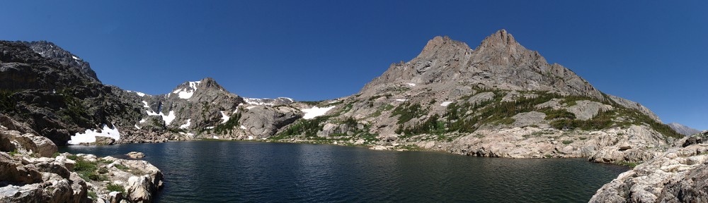
 The lake is scenic, but not dramatic. It’s small and shallow, with a large marshy area to the west. On my way out I ventured that way looking for another picture but there was no better view than where I sat and ate. Found a few nice flat rocks next to a handy snowbank to chill my beverage. It never ceases to amaze me how much better food tastes when enjoyed in a beautiful setting after three hours of hiking.
On the way down realized how fast the trail climbed. The guy at the lake complained about it, but I think he was complaining more about the sixty pound pack and herding the dogs. Hefting an extra sixty pounds, yeesh. That’s why I ‘m a day tripper. It took me three hours to get to the lake, but that includes probably twenty minutes watching those four guys cross the stream.
As I approached the ford, I was thinking how much more efficiently I crossed than they did. It took them quite a while and one went in the drink. But on my second crossing, I tossed one boot short and bounced into a puddle. Dang. It was standing upright, but it landed on its side. Maybe it didn’t get wet inside. Alas, it was pretty well soaked.
I sopped as much as I could with a paper towel, but it still felt pretty wet. I opened the tongue wide and set it down with as much sun shining in as I could. I took a short break and ate my cherries. Resigned to a wet foot for the remainder of the day I packed up and put the boots back on. For about thirty seconds my foot felt wet but after that it felt normal.
I made it back to the car shortly before four. No shade at the car, toasty, a bit dusty. Between the hot sun and the slow dusty drive to the highway I elected to keep the top on. I almost always return over Trail Ridge but figured the traffic there would be very bad so I drove back the way I came.
I stopped for a cold soda in Granby. There was a couple in a Polaris. Technically, they rode their Polaris; legally it’s a motorcycle and of course they get wet when it rains. Everybody was so busy asking them questions they didn’t notice me. It’s not often my car isn’t the center of attention.
Traffic moved pretty well, pretty much the speed limit all the way to Winter Park. I dispatched some slower cars going up the pass. People moved at a reasonable speed on the down side and before long we’re to I-70. The westbound traffic was horrendous. It only appeared to be stop-and-go in short blips, but it never moved fast, all the way to the bottom of Floyd Hill. And I’m sure it was that way all the way to the Eisenhower tunnel. Quite the contrast from what it was in the morning.
Fitbit app (GPS) says 4.51 miles, wristband recorded 5.97 miles with only 80 more paces on the way out. Foster says 4.8. Just a tad short of 25,000 paces for the round trip. Depending on how often the app queries the satellite, the GPS may read short on all the switchbacks. But I wouldn’t expect three tenths short, so I’ll assume the lower number is the most accurate.